Special Features

Image Libraries

Blog

click to enlarge
Downtown DC.

The National Capital Planning Commission (NCPC) study considering whether or not to raise DC’s height limit is unlikely to recommend major skyline-altering changes. But it will suggest tweaking the rules to add more flexibility, and leaves open the possibility of taller buildings outside downtown.

In his report to NCPC, executive director Marcel Acosta will recommend against raising the height limit significantly downtown, but will suggest changing the rules regarding rooftop penthouses.

The rules currently allow unoccupied mechanical-only penthouses to breach the height limit by a few feet in certain situations. Acosta will propose allowing active human use of those spaces.

Acosta will also recommend that NCPC further consider raising the height limit for areas outside downtown, where the impact on the monumental core would be negligible. That might allow places like Anacostia or Tenleytown to develop along more similar lines to Arlington and Bethesda.

The NCPC will vote on an official recommendation in November, after hearing Acosta’s report and gathering public feedback. Following that, Congress will have the power to either pass a bill making changes, or retain the status quo.

 Cross-posted at Greater Greater Washington.


Average Rating: 4.5 out of 5 based on 180 user reviews.

September 11th, 2013 | Permalink
Tags: master planning, urbandesign


The Bethesda Purple Line station is currently planned to squeeze into an existing tunnel below Bethesda’s Apex Building. But planners are now considering an alternate plan to tear down the Apex Building and redevelop the entire site.


Existing plan (top) and alternate proposal (bottom). Images by Maryland MTA.

Between Silver Spring and Bethesda the Purple Line will run on land from a former railroad line. Years ago the railroad sold the development rights above the tracks in downtown Bethesda. Now there are two buildings atop the rail corridor, the Apex Building and the Air Rights Building.

The Purple Line will pass easily under the Air Rights Building, but the Apex Building needs to accommodate a station. And while the tunnel there was designed to carry tracks, it wasn’t originally built to hold a station. The structural columns supporting the building come down into the rail tunnel, severely constraining the space.

Planners can squeeze a station in the existing space, but the result is a narrow platform crowded with building columns.


Apex Building column layout. Image by Maryland MTA.

Meanwhile, there are other problems with the existing arrangement. There’s not enough room in the tunnel for both a light rail station and a bike trail, so the trail is planned to be moved to the surface.

Also, building a subway station under the Apex Building would complicate any potential future redevelopment prospects. Since the Apex Building is only 5 stories tall, it’s already shorter than most other buildings nearby, and it will become a prime redevelopment candidate after Bethesda becomes a key Purple Line / Red Line transfer point.

Redeveloping now could solve the problem

The new proposal suggests tearing down the Apex Building, building the Purple Line station in a new custom-built trench, adding a 2nd tunnel for the trail, and then allowing the owners of the Apex Building to replace it with a bigger building.

Montgomery County is currently in talks with the owner of the building, and is working through a minor master plan amendment to determine the density and height.

If the new plan is approved, all the pieces will work together better. The Purple Line station will be simpler and more spacious, bike riders will have an uninterrupted dedicated trail, and one of the most transit-accessible properties in Montgomery County can be redeveloped at a more appropriate density.

It would be win/win/win.

As long as this doesn’t delay the rest of the Purple Line, I say let’s do it.

 Cross-posted at Greater Greater Washington.


Average Rating: 4.8 out of 5 based on 179 user reviews.

September 10th, 2013 | Permalink
Tags: development, lightrail, master planning, transportation, urbandesign


click to enlarge
NoMa station.

According to WMATA’s latest performance review, overall Metrorail ridership is dropping, and weekend ridership is plummeting.

Overall there were 4.2% fewer Metrorail riders in FY13 compared to FY12, and weekend ridership in June 2013 was fully 12% lower than weekends in June 2012.

Although Metro’s report claims the drop is due to Hurricane Sandy and the federal government’s unanticipated extra Christmas Eve holiday, the obvious explanation is terrible weekend service. Neither the hurricane nor a one-day holiday in December had any effect on that June 2013 number, after all.

Obviously Metro needs to perform a lot of maintenance on weekends. That’s necessary and appropriate. But WMATA could do (and used to do) more to make the system usable on weekends.

It’s not necessary to run 24-minute headways on an entire line in order to single track one short segment. For example, if Metro needs to single track between Foggy Bottom and Smithsonian, they should still be able to run regular service between Vienna and Foggy Bottom.

The location of track crossovers does limit where Metro can turn trains around, but crossovers are never more than 2 or 3 stations apart, so it is always possible to turn trains around somewhere.

WMATA’s heavy maintenance schedule hurts, but it’s a temporary problem. In a few years, presumably, maintenance work will catch up and weekend shutdowns and single tracking won’t be as common. On the other hand, WMATA’s denial to admit terrible service turns riders away is a potentially bigger problem. And if they’re not putting out the best service possible, that’s a huge problem.

 Cross-posted at Greater Greater Washington.


Average Rating: 5 out of 5 based on 207 user reviews.

September 9th, 2013 | Permalink
Tags: metrorail, transportation


Monroe Street Market, the large multiblock development adjacent to Brookland Metro station, is making rapid progress. The first buildings are occupied, and shops are beginning to open.


The landmark Brookland sign at Monroe Street Market.

The new town center will stitch together the residential neighborhood, Catholic University, and the Metro station like never before. Although it’s a smaller scale than what’s gone in at Columbia Heights, and will always be more of a local node than regional shopping mecca, it will be no less transformative to the livability of the neighborhood.

One of the first shops to open for business is Analog, a boutique and on-site crafting workshop selling, among other things, DC- and geography-themed paper goods. My wife is co-owner of Analog, and I couldn’t be more proud of her.

More small shops and artist studios will open through September, with the larger retailers coming in spring 2014. The largest will be a new Barnes and Noble bookstore, which will include a section for Catholic University textbooks.

Here are a few more pictures of Monroe Street Market and Analog.

Monroe Street Market’s Arts Walk (top), 2nd building (bottom left), and Analog (bottom center & right).

 Cross-posted at Greater Greater Washington.


Average Rating: 4.5 out of 5 based on 167 user reviews.

September 6th, 2013 | Permalink
Tags: development


DC and the National Park Service are partnering to redesign Franklin Square, the largest of the parks lining K Street in downtown DC. As they draw up plans, here are 4 ideas that will help transform Franklin from one of DC’s most underused parks into one of America’s best public spaces.


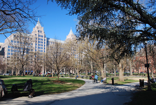
Franklin Square today.

Work with the city’s edges

Most of downtown DC’s existing squares pay little attention to what’s around them. They’re laid out symmetrically, with paths emanating outward from a central statue through grass and trees to the street. Each side is close to identical, regardless of what’s across the street. That works well for small spaces like Dupont Circle or McPherson Square, but not for larger ones like Franklin Square.

Larger squares need multiple sub-areas, each with distinct attributes that reflect what’s around them. Franklin Square is big enough that it shouldn’t be symmetrical. The more active 14th Street side should be more welcoming to large numbers of people, and should have more hardscaping and mixed-use. Conversely, the less active 13th Street side should be quieter and more park like.

Embrace transit

One big reason the 14th Street side is more active is the entrance to McPherson Square Metro station at 14th and I Streets. That’s a big opportunity. Rather than treating that as just another corner, no different from the other 3, the new design for Franklin Square should focus acutely on the Metro station. That corner should be the most intense part of the park, and should function as its unofficial center.

New York’s Union Square is a great example of what that might look like, with its hardscaped plaza surrounding a subway entrance, and quieter park area behind.

But the Metro station isn’t the only big transit component to Franklin Square. It’s also a major transfer point for several of DC’s busiest bus routes. The southern edge of Franklin Square, along I Street, is essentially one long transit station, serving hundreds if not thousands of passengers per day.

But Franklin Square’s current layout treats I Street the same as all the others. Landscaping curves away from the sidewalk, and benches face inwards towards the center of the park. As a result, every day tons of bus passengers stand in the grass facing I Street, while most of the benches sit empty, facing the wrong way. Except the grass is actually dirt, because too many people stand in it for grass to grow.

By ignoring bus passengers, Franklin Square’s current layout makes it a worse park, and a worse transit stop. Embracing I Street with better transit amenities would make the whole park better for everyone.

And don’t forget that the northern edge, along K Street, will eventually have streetcar service.

More stuff is better, but make it visible

Franklin Square’s existing layout should teach us one thing, at least: That it’s not always enough to simply plop some green space in the center of the city and hope for the best. If designers phone it in and just build a big grass lawn, the result won’t be any better than what’s there now.

The best parks are surrounded by extremely busy sidewalks, from which pedestrians naturally spill over and hang out. Except for the corner with the Metro station, Franklin Square is surrounded by moderately busy sidewalks, but not extremely busy ones. That means the park needs amenities to draw people.

Interactive features like movable seating, splash fountains, and vendor kiosks are all great ways to add vitality to parks, and should be considered in Franklin Square.

The existing fountain at Franklin Square fails to draw many users because it’s nothing but a squat ledge set in a sunken plaza. It’s impossible to see until you’re right on top of it. If designers want people along the park’s edges to enter and move towards the middle, there need to be highly-visible, interesting-looking things in the middle. That means they need to be taller than 2 feet.

Finally, the park does need a large central landmark. It may make sense to put such a thing at the southwest corner near McPherson Metro rather than the center, but regardless of its location within Franklin Square, there should be some single defining icon, to act as gathering place and landmark. A more grand fountain, or an archway, or a clock tower, or something.

Consider what’s missing from downtown

Since Franklin Square is so much larger than McPherson or Farragut, it can fit things the others can’t. It’s worth asking what amenities are missing from downtown DC that
Franklin Square might accommodate. Downtown doesn’t have any ponds, like Boston’s Public Garden. Nor does downtown DC have a concert shell. Surely there are others.

Franklin Square won’t be able to fit every possible idea, and some that it can fit may not be the best uses for Franklin’s particular needs anyway. But redesigning such an important square isn’t an opportunity that comes along every day, so while we have this chance it’s worth exploring all the options.

The National Park Service will hold a public meeting to discuss the redesign on the evening of October 2, at the Sheraton at 1201 K Street, NW. Come with ideas!

 Cross-posted at Greater Greater Washington.


Average Rating: 4.4 out of 5 based on 203 user reviews.

September 5th, 2013 | Permalink
Tags: parks, urbandesign


click to enlarge
A portion of Arlington’s existing bike map.

Arlington’s bike planners are designing a new bike map that will highlight the most comfortable routes, instead of focusing strictly on infrastructure. They want your help, to figure out the most important things to show on the map.

Most bike maps focus on infrastructure, with separate symbols for things like bike lanes, cycletracks, and trails. But another school of thought suggests they should focus on rider comfort, putting more emphasis on mixed-traffic roads with slow-speed car traffic, and doing more to call out things like hills.

To help strike the right map balance and illustrate the right things, planners are asking bike riders in the region to take a short survey. The survey has 13 questions and should take less than 5 minutes to complete.

 Cross-posted at Greater Greater Washington.


Average Rating: 5 out of 5 based on 221 user reviews.

September 4th, 2013 | Permalink
Tags: bike, maps, transportation


Media


Site
About BeyondDC
Archive 2003-06
Contact

Search:

GoogleBeyondDC
Category Tags:

Partners
 
  Greater Greater Washington
 
  Washington Post All Opinions Are Local Blog
 
  Denver Urbanism
 
  Streetsblog Network


BeyondDC v. 2013d | Email | Archive of posts from 2003-2006