|
Special Features


Image Libraries


|
|
Blog
|
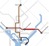
The 22-mile priority streetcar network. Image from DDOT. |
DDOT thinks they may be able to build a 22-mile streetcar system in just 5 years. Is that really possible?
Although DC has planned a 37-mile streetcar network, planners are currently focusing strongly on the first 22 miles. The H Street line is under construction and in the home stretch, while planning has started for the crosstown line and the north-south line.
Project spokesman Dara Ward says DDOT hopes to build the 22-mile system in 5 years. That’s optimistic, but possible.
Streetcars are relatively easy to build. Actual construction can take anywhere from a few months to a couple of years, depending on the specifics. Planning and engineering take a couple of years as well. But if funding is ready, there’s no controversy, and everything moves along on schedule, 5 years is about how long it should take.
If that seems impossible based on how long it’s taken H Street, remember that H Street is atypical. DDOT installed streetcar tracks there in 2009, years before the planning was really done, because they were rebuilding the street anyway and didn’t want to go to the expense of tearing it up twice.
So really H Street planning and construction came in two separate phases. Each phase took a couple of years. If it had all been done at once, it wouldn’t have started until more recently, and likely could have been done within about 5 years.
It does often take longer. But usually the big holdups are politics or funding. Those issues can tie any project up for decades. And the first line is always the hardest.
But after discussing streetcars for years, DC seems to have the money and politics pretty well worked out. If they stay the course and focus strongly on moving forward, 5 years is doable.
Difficult and optimistic, yes. But not a complete fantasy.
Update: DDOT spokesperson Dara Ward clarifies that the 5 year estimate is for construction only, and doesn’t begin until planning is complete. – 10.1.2013
 Cross-posted at Greater Greater Washington. Cross-posted at Greater Greater Washington.
Average Rating: 4.5 out of 5 based on 223 user reviews.
September 30th, 2013 | Permalink
Tags: streetcar, transportation

At 10:30 this morning, the first bikesharing stations opened in Maryland. 14 of 50 planned stations in Montgomery County are now available for cyclists. The rest will come online gradually over the coming weeks and months.

Capital Bikeshare map, zoomed to the new stations in Montgomery County.
Average Rating: 4.6 out of 5 based on 207 user reviews.
September 27th, 2013 | Permalink
Tags: bike, transportation
Reston’s Lake Anne Village Center could soon expand with a larger main street and more housing.

Lake Anne Village Center, with proposed additions.
Rendering from Republic Land Development.
Reston Town Center is one of the most well-known suburban downtowns in the DC region, but it’s not the only town center in Reston. In addition to the big one, Reston has several smaller village centers spread around the surrounding neighborhoods.
The largest of those is Lake Anne Village Center, which has a pleasant waterfront and a 15-story apartment tower that was Reston’s tallest building for decades. Before the big town center came along, Lake Anne was the heart of Reston.
Now it’s set for a revival. Developers working with Fairfax County propose to expand the village center, with a larger main street, nearly 1, 000 new residential units, and a second high rise.
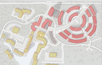
Lake Anne revitalization plan, with proposed new buildings in red.
Image from Republic Land Development.
While it makes great sense to add infill to Reston’s village centers, especially Lake Anne, it is too bad this plan is still so car oriented. The main street extension is nice, but the circle-shaped residential area to the north is unnecessarily suburban. If the purpose of dense mixed-use areas is to promote walkability, why not actually make them walkable?
In a location like Reston, it’s true that most residents will have cars. That’s fine. But why so many landscaped setbacks? Why are the parking lots between the buildings rather than behind them? And why is all the car traffic funneled onto a single street with only one connection to the arterial highway, instead of having a grid?
The topography of the site looks challenging, and there may be pedestrian paths that aren’t immediately obviously in the plan. Still, Fairfax should consider these questions as this development moves through the approval process.
Cross-posted at Greater Greater Washington.
Average Rating: 4.7 out of 5 based on 161 user reviews.
September 26th, 2013 | Permalink
Tags: development
The DC Office of Planning (OP) suggests replacing the blunt citywide height limit with more targeted rules that would slightly increase heights downtown, and give DC the option to allow taller buildings elsewhere.
Under the proposal, the existing federal height limit would only apply to the L’Enfant City, and would change to allow modestly taller buildings. Elsewhere, DC would set its own limits using the local zoning process, which already requires federal and public input.
DC’s skyline today. Photo by the DC Office of Planning.
In many parts of DC, the zoning code already restricts height more than federal law, so this would result in no change for those areas. But for other peripheral neighborhoods, especially near Metro stations, it could potentially allow taller buildings.
Even so, it would take long public processes to rezone any land for taller buildings. To do so, the change would first have to be part of the District’s Comprehensive Plan. After that, the Zoning Commission has to approve specific new zoning. At each stage there are opportunities for public feedback, and 2 of 5 members on the Zoning Commission are federal appointees.
Within the L’Enfant city, the report recommends modifying the height limit to allow slightly taller buildings. The current height limit restricts buildings to the width of the street plus 20 feet. OP recommends changing that to be simply 125% the width of the street.
In practice that’s a very modest increase. Pennsylvania Avenue is 160 feet wide, so its height limit is currently 180 feet. Under OP’s 125% proposal, it would rise to 200 feet.
OP’s report follows a National Capital Area Planning Commission (NCPC) study of the issue. NCPC’s own recommendations earlier this month called for similar but more modest changes.
For downtown DC, NCPC recommended allowing humans to use mechanical penthouses, which would effectively raise the height limit by one floor, as long as there are setbacks. Outside downtown, NCPC suggested further study but not yet any action.
OP argues that ensuring the economic stability and vitality of the capital city is a compelling federal interest, and reason to modify the height limit.
The ultimate decision will rest with Congress, which passed the original height limit law and is the only body which can change it.
Cross-posted at Greater Greater Washington.
Average Rating: 4.6 out of 5 based on 229 user reviews.
September 25th, 2013 | Permalink
Tags: urbandesign
WMATA’s Metro Forward Facebook page has a fun set of Metrorail construction pictures, dating from the mid-1970s. They’re a fascinating look back at a wholly different Washington.
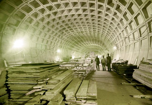
Archives in 1975. Photo from WMATA.
The most interesting may be a 1974 picture of Gallery Place under construction. What’s now the Verizon Center is a dirt patch and a collection of holes.
But my favorite is probably the one of Archives station in June, 1975, pictured above. In the picture, workers have yet to add the tracks, platforms, or mezzanines, so the vaulted ceiling runs uninterrupted for the entire length of the station. It looks so much more voluminous!
Cross-posted at Greater Greater Washington.
Average Rating: 5 out of 5 based on 244 user reviews.
September 24th, 2013 | Permalink
Tags: history, metrorail, transportation
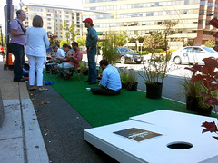
Today is Park(ing) Day, and all across the US city-dwellers are claiming car parking spaces and temporarily converting them to parks for people.
Instead of using all our street space to store cars, why not use some of it to make our cities nicer places to live? On Park(ing) Day, groups find an on-street parking space, pay the meter to claim it legally, and instead of parking a car, they park seats, tables, plants, or whatever.
Groups are sponsoring parklets all over the DC region today. I visited two near my Arlington office alone.
 |
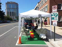 |
| Parklets on Clarendon Boulevard (left) and 14th Street North (right). |
Cross-posted at Greater Greater Washington.
Average Rating: 4.5 out of 5 based on 282 user reviews.
September 20th, 2013 | Permalink
Tags: parks, roads/cars, transportation, urbandesign
Graphic designer Peter Dovak has created a geographically accurate version of the new Metro map that WMATA released last week.
Peter’s map matches WMATA’s style as closely as possible, except it’s to scale. It looks stunningly like it could be an actual WMATA-produced map.
While this map is wonderful and fun, it also strongly illustrates why Metro opts for a more abstract official design. There’s so much empty white space in the suburbs, and the core is so cluttered, that a less accurate diagram is easier for riders to read.
See more at Peter’s website.
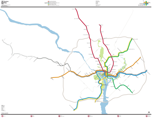
Map by Peter Dovak.
Cross-posted at Greater Greater Washington.
Average Rating: 5 out of 5 based on 249 user reviews.
September 18th, 2013 | Permalink
Tags: maps, metrorail, transportation
Interesting fact of the day: Jericho, in the Palastinian-administered West Bank of Israel, is generally considered to be the oldest city in the world. It was founded sometime around 9000 bce, making it upwards of 11, 000 years old.
It’s more than 6, 000 years older than the oldest Egyptian pyramids. It predates Sumer, the first of the world’s great civilizations, by 4, 500 years. It was more ancient to the Romans than the Romans are to us, by far.
It’s been sacked, conquered, and abandoned at various times throughout history, but people always come back.
Suddenly, DC’s Victorian rowhouses seem a little less impressive.

Jericho. Photo by gashwin on flickr.
Average Rating: 4.4 out of 5 based on 158 user reviews.
September 17th, 2013 | Permalink
Tags: History of cities
Fun things hide in city planning office storage rooms. I recently stumbled upon this fascinating Washington Post special from the 1982 day I-66 opened.
My favorite part: “I-66 means that the days of the great highway wars are ending.” LOL.
The full story is online.
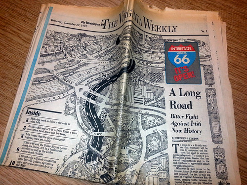
From December 22, 1982.
Average Rating: 5 out of 5 based on 199 user reviews.
September 13th, 2013 | Permalink
Tags: fun, roads/cars, transportation
WMATA has released its next Metrorail map, proposed to go into trains and stations in time for the Silver Line to open.
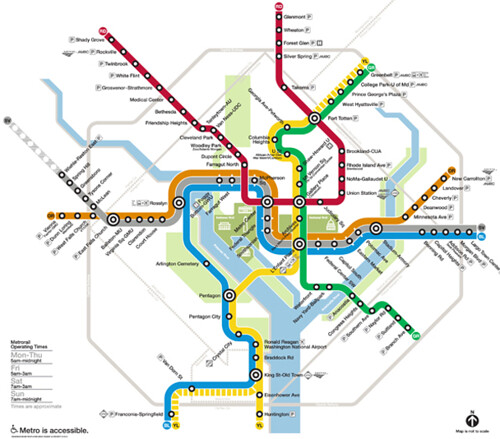
Proposed new map. Image by Lance Wyman for WMATA.
A new map is necessary to fit the complete Silver Line, which will run all the way through downtown DC and into Prince George’s County. The existing Metrorail map just shows the portion of the Silver Line that’s currently under construction, but the route will actually join with the Orange Line and run through DC.
The new map will also show Phase 2 of the Silver Line, extending all the way to Dulles Airport and Loudoun County. Phase 2 won’t open for several more years, but work on it recently started, and showing it on the map will help riders to become familiar with it sooner rather than later.
The new map incorporates several of the elements proposed in designer Lance Wyman’s draft from March, which was then refined in May. The new map is Wyman’s most graceful and streamlined yet.
Wyman narrowed the line thickness, lightened the station symbols, and changed the placement of the Silver Line in central DC, to be between the Blue and Orange Lines rather that atop them both.
The “whiskers” at stations where the 3 lines all share track are now white instead of solid black. The “pill” option for those shared stations, from the May draft, has been abandoned.
Overall, these changes make the map lighter and airier-looking, compared the March draft which was clunky and cluttered, especially in the DC core.
One thing missing from this map is DC’s H Street streetcar, which should open for service about the same time as the Silver Line. Although the streetcar won’t be operated by WMATA, it will certainly be an important rail service in the District.
As streetcar and BRT plans throughout the region move forward, WMATA may want to follow Boston’s lead, and show surface transit on its map as well.
But that’s a problem for another day.
Cross-posted at Greater Greater Washington.
Average Rating: 4.7 out of 5 based on 221 user reviews.
September 12th, 2013 | Permalink
Tags: maps, metrorail, streetcar, transportation
|
Media


Site
About BeyondDC
Archive 2003-06
Contact
Category Tags:
Partners
|


