|
Special Features


Image Libraries


|
|
Blog
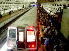
WMATA may shut down entire rail lines for months in order to catch up on maintenance more quickly (though, officials noted, no decisions have been made yet). If a shutdown does happen, Metro must thoroughly prepare, communicate, and provide riders who rely on Metro with reasonable alternatives.

Special event bus shuttles. Photo by DDOT DC on Flickr.
A months-long shutdown may make sense
For years, WMATA has been struggling to perform maintenance at nights and on weekends. There’s so much work to do that they can’t complete it all.
Meanwhile, many riders who’ve endured year after year of worsening service are abandoning Metro, especially on the weekends when trains can be 30 minutes apart.
A months-long shutdown would theoretically put an end to that, or at least significantly reduce the need for weekend track work. It would let WMATA catch up on all its maintenance needs for a line in one fell swoop. We’d be trading a few months of pain for years of happiness.
WMATA GM Paul Wiedefeld says he is indeed considering the idea. He adds, “In the last few years, we’ve been trying to do this [maintenance] in a sort of piecemeal way, and basically we’ve alienated everyone.”
He’s right. Working at night and on weekends is fine when you’re just doing preventative maintenance. But after years of increasingly terrible weekend service, it’s become clear that model won’t work with WMATA’s need for major rebuilding. With no end to the rebuilding in sight, it’s time to try something new.

This is getting old. Photo by the author.
Closing an entire line end to end may not prove necessary. You can rebuild the Virginia section of a line without closing the Maryland section, for example. And closing the core is much harder than closing outer sections. But closing long segments of a line, say four or five stations long, may well make a lot of sense. On the other hand, if a whole line needs work, maybe shutting it down completely is the way to go.
Whether or not WMATA has the equipment and work crew capacity to do such a big job is an open question. But if so, or if it can expand as needed to do so, it may not be a terrible idea.
Leaving riders without options wouldn’t be acceptable
So yes, it’s very possible that closing major segments of Metro lines for months would be the best way to get this painful decade of rebuilding behind us.
But we absolutely cannot simply shut down Metro and hope for the best. Metrorail is not an optional service for the Washington region. Hundreds of thousands of people rely on it every day, including many who don’t have access to cars. Telecommuting saved us for one day, but can’t work for months on end.
We’ve literally built our region around Metro. Without it, 166 blocks of downtown DC would have to be bulldozed and converted to parking garages.
Simply closing Metro without providing alternatives isn’t an option. Too many people wouldn’t be able to reach their jobs. It would be a calamity, economically and for thousands, personally:
We’d need bus shuttles, bus lanes, and more
If this is really going to happen, WMATA and the affected jurisdictions would have to work together to provide transit alternatives. We’d need special bus shuttles to replace the shuttered Metro line, temporary bus lanes to make longer-distance bus travel fast enough to be practical, greatly expanded transportation demand management, and more. We’d need a comprehensive transportation management plan.
Such a plan might look something like what Matt Johnson suggested in 2013, when WMATA considered closing part of the Red Line for six weeks. That shutdown hasn’t happened, but many of the same ideas would be necessary anywhere.
Luckily, these are not impossible ideas. Other cities have made long term closures work. We could too.
It wouldn’t be easy, and it would require sacrifice from everyone, including drivers who don’t use Metro. It’s impossible to stop running a transit line that carries a hundred thousand passengers without making life hard. Substitute buses absolutely would not be as good as Metrorail, not for transit riders and not for car drivers who have to share road space.
But the current situation is hard too.
WMATA will need to study this concept in detail. Then they’ll need to share their detailed findings with the public. What are the real options, what are the trade-offs, how much time and money would this save, and what will the Metro system look like when it’s over? If Metro expects the public to buy this idea, they’ll need to be forthright.
But it’s possible. WMATA could do this and it might be successful, if and only if they take the time and money to plan, prepare, and do it correctly.
 Comment on this at the version cross-posted to Greater Greater Washington. Comment on this at the version cross-posted to Greater Greater Washington.
Average Rating: 5 out of 5 based on 188 user reviews.
March 31st, 2016 | Permalink
Tags: metrorail, transportation

|
Farragut West. |
WMATA’s PlanItMetro blog has released a trove of data on Metro station use. Here’s one snippet: All 91 stations, ranked by the average number of riders who entered the faregates each weekday in February, 2016.
- Union Station 29, 371
- Gallery Place 25, 537
- Farragut North 24, 597
- Metro Center 24, 330
- Farragut West 20, 917
- Foggy Bottom 20, 121
- L’Enfant Plaza 19, 343
- Dupont Circle 18, 653
- Pentagon 14, 584
- McPherson Square 14, 340
- Rosslyn 13, 666
- Pentagon City 12, 558
- Silver Spring 12, 269
- Columbia Heights 11, 840
- Shady Grove 11, 732
- Crystal City 11, 480
- Ballston 10, 759
- Vienna 10, 005
- Bethesda 9, 883
- NoMa 9, 038
- Judiciary Square 8, 722
- Friendship Heights 8, 503
- Archives 7, 829
- Fort Totten 7, 543
- Federal Triangle 7, 381
- Wiehle 7, 306
- King Street 7, 238
- New Carrollton 7, 209
- Smithsonian 7, 149
- Court House 7, 074
- Huntington 7, 002
- Capitol South 6, 957
- Navy Yard 6, 834
- Franconia-Springfield 6, 821
- Anacostia 6, 799
- U Street-Cardozo 6, 671
- Tenleytown 6, 587
- Brookland 6, 324
- Van Ness 6, 158
- Georgia Avenue-Petworth 6, 151
- Glenmont 5, 881
- Woodley Park 5, 861
- Greenbelt 5, 738
- Rhode Island Avenue 5, 727
- Federal Center SW 5, 697
- Reagan National Airport 5, 631
- Medical Center 5, 591
- Eastern Market 5, 500
- Branch Avenue 5, 449
- Takoma 5, 329
- Grosvenor 5, 206
- Shaw 4, 989
- Suitland 4, 918
- Southern Avenue 4, 751
- Braddock Road 4, 543
- Largo Town Center 4, 435
- Clarendon 4, 423
- Prince George’s Plaza 4, 385
- Rockville 4, 245
- Mt. Vernon Square 4, 243
- Twinbrook 4, 163
- Dunn Loring 4, 081
- College Park 4, 068
- Waterfront 4, 008
- Cleveland Park 3, 961
- East Falls Church 3, 913
- Virginia Square 3, 898
- Wheaton 3, 864
- White Flint 3, 641
- Potomac Avenue 3, 635
- West Hyattsville 3, 402
- Addison Road 2, 971
- Van Dorn Street 2, 970
- Tysons Corner 2, 857
- Benning Road 2, 823
- West Falls Church 2, 715
- Naylor Road 2, 471
- Congress Heights 2, 431
- Stadium-Armory 2, 430
- Minnesota Avenue 2, 387
- Forest Glen 2, 230
- Capitol Heights 1, 893
- Morgan Blvd. 1, 849
- Landover 1, 667
- McLean 1, 562
- Eisenhower Avenue 1, 486
- Deanwood 1, 347
- Cheverly 1, 153
- Greensboro 1, 079
- Spring Hill 1, 042
- Arlington Cemetery 363
Comment on this at the version cross-posted to Greater Greater Washington.
Average Rating: 4.4 out of 5 based on 202 user reviews.
March 30th, 2016 | Permalink
Tags: metrorail, transportation
Rockville Pike could one day become a 252-foot-wide mega boulevard with 12 car lanes, 4 bike lanes, 2 bus lanes, and over 50 feet of landscaping. But in designing a street with more than ample room for cars, bikes, and buses, planners abandon any hope the street will be walkable.

The plan for Rockville Pike. Image from Rockville.
Everybody gets a lane!
Rockville Pike is one the most important retail strip highways in the Washington region. Like most 20th Century retail roads, it’s designed for cars, and it carries a lot of them.
Rockville wants to make it a more urban main street, so planners there are drawing up a redevelopment plan. It’s a laudable goal, and it’s not easy on a high-traffic state highway like Rockville Pike.
At first glance, this plan has all the components of a good complete street design: Tree-lined sidwalks, protected bikeways, a center-running dedicated busway. Every mode gets all the street width it could possibly want.
And why not? Why go through the political headache of forcing the community to make the difficult choice between fewer car lanes versus bikes or BRT if you can fit everything in? With a mega boulevard like this, everybody gets what they want, and nobody loses. Right?
Wrong.
Walkability loses, and it’s the most important factor
At 252 feet wide, the new Rockville Pike will be practically impossible for pedestrians to cross. It will take multiple traffic light cycles and multiple minutes for anyone to cross.
Instead of a main street, Rockville will have a barrier. And that is a big problem for the rest of the plan.
Transit oriented development doesn’t work unless it’s walkable. If Rockville Pike is too wide, development on one side of the street will be effectively cut-off from development on the other side. Riders won’t be able to easily access the BRT stations. People will drive for even short trips. The concept of a community where people don’t need to drive everywhere will break down.
If you can’t walk, other multimodal options don’t work. Pedestrians are the linchpin to the whole thing.
To be sure, some level of compromise is always needed. If walkability were the only factor that mattered, all streets would be pedestrian-only. We add in car lanes, bike lanes, and transit because we have to make longer trips possible, and that’s a good thing.
But there’s a balance, and 252 feet veers so far to accommodate long distance travel that it seriously sacrifices short distance walking. In so doing, Rockville undermines the very foundation on which its redevelopment plans rest.

Make pedestrians a priority
The Pike needs to be narrower. Assuming the sidewalks, busway, and three general car lanes each direction are sacrosanct, that still leaves a lot of potential fat to trim.
Are the service roads really necessary if the plan also includes new parallel local streets? Do we really need redundant bi-direction bikeways next to both sidewalks? Could we possibly reduce the 74 feet of various landscaping, buffer, and turn lanes?
These would be difficult trade-offs, to be sure. But there are massive negative consequences to an uncrossable mega boulevard.
If Rockville wants the new Pike to work as multimodal urban place, pedestrians need to become a priority.
Comment on this at the version cross-posted to Greater Greater Washington.
Average Rating: 4.4 out of 5 based on 298 user reviews.
March 24th, 2016 | Permalink
Tags: bike, BRT, master planning, roads/cars, transportation, urbandesign
Traffic wasn’t nearly as bad as it could have been during Wednesday’s Metro shutdown. Telecommuters were a big reason why. That’s fine for a one-time event, but it won’t work every day.

Photo by Elvert Barnes on Flickr.
We don’t know exactly how many people telecommuted during the Metro shutdown, but the number was surely gigantic. Anecdotal evidence suggests there could have been hundreds of thousands of normal commuters who simply didn’t travel into their offices.
Obviously when you remove tens or hundreds of thousands of commuters from the daily rush, that helps a lot with traffic.
But it’s one thing for so many people to telecommute all at once because of a freak one-time event. It would be quite another to see those levels of telecommuting over and over, work day after work day.
When it’s just one day, you can reschedule your meetings, live without your physical files, and put off working with specialized equipment. For just one day it’s easy to focus on email and other things you can do from home.
But at some point, office workers have to go in to their offices. As technology improves, the day-to-day telecommuting rate may well increase, but at least for now it’s not going to be possible for so many people to make telecommuting an everyday option.
Workers can avoid rush hour travel in large numbers for a freak event, but not everyday. If our city didn’t have Metro, the daily commute would rapidly become much worse than what happened on Wednesday.
Comment on this at the version cross-posted to Greater Greater Washington.
Average Rating: 4.9 out of 5 based on 223 user reviews.
March 18th, 2016 | Permalink
Tags: metrorail, roads/cars, transportation
This amazing map from 1861 shows a federal government proposal to redraw the borders of Maryland, Virginia, Delaware, and DC. The reason: To spite Virginia for the Civil War and better-protect the capital from attack.

1861 proposal to redraw the borders of Maryland, Virginia, Delaware, and DC. Image by Harper’s Weekly.
The map is from an 1861 edition of Harper’s Weekly, and is based on an idea from federal Secretary of War Simon Cameron. Here’s how Harper’s Weekly described the idea:
This arrangement would reduce the size of the State of Virginia at least one-half, leaving the name of Virginia to that part only which is now mainly loyal.
The disloyal section, comprising all the great cities of Virginia—Richmond, Norfolk, Fredericksburg, Lynchburg, etc.—and all the sea-coast, would be annexed to Maryland, while Delaware would rise, by spreading over the whole peninsula between the Chesapeake and the ocean, to be a State of considerable magnitude.
Under this reconstruction Maryland would become one of the three great States of the Union. We need hardly direct attention to the clause in the Secretary’s report which hints that emancipation in Maryland must be the price paid for this acquisition of territory.
Alexandria and Arlington would have returned to DC, which would have remained independent of any state.
When Cameron came up with his idea, the Civil War was less than a year old. The western more rural portions of Virginia had hoped to remain in the Union, while the more urban eastern portions had voted overwhelmingly to secede. In theory, this proposal therefore would have accomplished several goals. It would have:
1. Separated off the loyalist western parts of Virginia, allowing them to be reintroduced to the Union as a northern state.
2. Punished eastern Virginia, the intellectual and economic heart of the Confederacy, by taking away its independence as a state.
3. Rewarded Maryland and Delaware for remaining in the Union.
4. Protected Washington from having a hostile territory directly across the Potomac.
It’s not as crazy as it seems
In 1861, as Cameron was making this proposal, West Virginia was already in the process of splitting off from Virginia to become its own state. How exactly to draw its borders and what to call it was a perfectly reasonable question.
The most doubtful part of this idea is the notion that new-and-bigger Maryland would be a safe northern state. Although Maryland never seceded, it was a slave state and its loyalty to the Union during the Civil War was tenuous at best.
Adding the wealthy and populous parts of Virginia to Maryland seems more likely to have drawn Maryland towards the south than vice versa. Presumably that’s why the deal would have required Maryland to free its slaves.
Of course as we all know, this proposal didn’t work out. West Virginia’s boundaries and name became official in 1863 when it was admitted to the Union as its own state, and Virginia was itself readmitted in 1870 following four brutal years of Civil War.
But it’s interesting to look back and see what could have happened, had history turned out just a little bit differently.
Comment on this at the version cross-posted to Greater Greater Washington.
Average Rating: 4.7 out of 5 based on 191 user reviews.
March 3rd, 2016 | Permalink
Tags: government, history
In 1912 Baltimore’s city leaders hoped to annex this large chunk of Baltimore County. Had that happened, the city limits would have extended from just shy of downtown Towson to just shy of Ellicott City.

Image from the State of Maryland.
Baltimore annexed big chunks of land in three successive waves: One in 1817 that took the city as far as North Avenue, a second in 1888 up to about 40th Street, and a third in the early years of the 20th Century.
Like other US cities, Baltimore was expanding rapidly in the early 20th Century amidst a wave of streetcar-induced sprawl. Suburban areas lacked city services like sewers, parks, and police, so central cities often annexed surrounding land.
By about 1910, Baltimore was ready for another round of annexation. Exactly how much land the city should annex became a major hot-button issue of the day, with proposals ranging from no expansion to the aggressive, far-ranging one pictured above.
In 1918 a compromise plan eventually won out, settling Baltimore’s boundaries at their current extents.
By the time America’s post-World War II suburbanization boom happened, the national mood had shifted against central cities. A 1948 amendment to Maryland’s state constitution outlawed any further expansion of Baltimore city, and thus the borders haven’t changed since.
Comment on this at the version cross-posted to Greater Greater Washington.
Average Rating: 4.4 out of 5 based on 259 user reviews.
March 3rd, 2016 | Permalink
Tags: government, history, maps
|
Media


Site
About BeyondDC
Archive 2003-06
Contact
Category Tags:
Partners
|


