|

Close up of Bixi bikes in Montreal |
Regular readers may recall that in late summer I visited Montreal, promising pictures of the city and its expansive bike-sharing system, Bixi.
Oh right.
You can view all 238 photos via flickr, or see the highlights in a series of three narrated threads on the SkyscraperPage urban photography forum:
Overall I was extremely impressed with both cities, and in particular with Montreal’s transportation. Bixi was convenient, well-located, easy to use, and inexpensive. Cycling in the city was a breeze, thanks to ubiquitous cycle tracks and large numbers of fellow cyclists. We would do well in Washington to copy what we can.
Average Rating: 4.5 out of 5 based on 281 user reviews.
February 25th, 2010 | Permalink
Tags: bike, galleries, metrorail, transportation
Washingtonian Magazine is looking for stories related to the housing boom and bust, and asked BeyondDC to put out a call for help. Here is their ad:
Did you buy a home during the frantic years of bidding wars and packed open houses? Or did you sell your house for more than you’d ever imagined possible? Did you see your neighborhood transformed? If so, we’d love to hear from you. If you have a story to share, please email Washingtonian features editor Denise Kersten Wills at dwills@washingtonian.com.
Average Rating: 4.7 out of 5 based on 204 user reviews.
February 24th, 2010 | Permalink
Tags: events, in general
WMATA Board member Chris Zimmerman, in regards to a December, 2009 suggestion that Metro GM John Catoe be fired: (source)
“There is every reason to believe we currently have one of the very best transit managers in the country, and it is not clear that we would ever attract someone as good or better by firing him.”
WTOP, today: (source)
“Metro is finding it hard to corral a temporary replacement for the top position at the transit agency… so far, those that have been offered the job of interim general manager have turned it down. A Metro source tells WTOP that at least two internal candidates have been offered the top spot at Metro, but they have declined. External candidates are said to have been offered the position and they have declined.”
This is what scapegoating gets us. The WMATA GM job was always going to be a hard one, but with a public more interested in pointing fingers than finding solutions, it becomes impossible. As a result, nobody good wants the job.
If transit advocates want to be helpful, we ought to spend our time informing readers what Metro’s real problems are, rather than blissfully casting blame on easy targets. Metro’s problems are not the fault of any one person, or any one group of people. Metro’s problems boil down to inappropriately taking the system for granted. Workers take safety for granted without being careful, the public takes it for granted that the system will continue to function despite maintenance being chronically under-funded, and regional leaders take it for granted that riders would rather protect their pocket books than pay for what needs to be paid for.
Metro will be fixed when those issues are adequately addressed. In the mean time, let’s stop doing what doesn’t work. No more scapegoating.
Average Rating: 4.6 out of 5 based on 293 user reviews.
February 22nd, 2010 | Permalink
Tags: metrorail, people, transportation
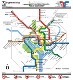
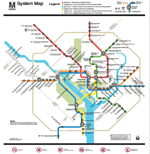
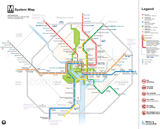
In 2007 graphic design firm KICK famously proposed redrawing the New York subway map. The new map they produced was more straightforward and intuitive than the official subway map, but also more diagrammatic. MTA eventually dismissed the proposal, but not before considerable internet buzz. Graphic designers and transit nerds still talk about it to this day.
And now graphic designer Cameron Booth has done the same for Washington. WMATA’s existing map is one of the world’s more iconic, but it has its faults, and as Booth notes, once the Silver Line is up and running there simply won’t be room on the page to continue the current scheme. His proposal is worth discussing.
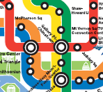
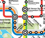
Three versions of the DC Metro map
Click each to enlarge.
| |
Existing WMATA map |
Future WMATA map
with narrower lines |
Booth map |
Full map |
 |
 |
 |
| Downtown |
 |
 |
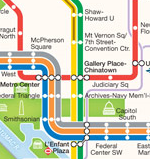 |
The Booth map has some real advantages. Instead of relying on clumsy call-out boxes for special notes, it graphically integrates all levels of peak and non-peak service. It shows MARC routes. Labels are more well-placed. It looks more up-to-date and professional.
On the other hand, Booth’s map has some real disadvantages too. First and foremost, it suffers from that most cardinal sin of transit maps: it’s too spaced out on the periphery and too crowded downtown. The whole point of using diagrams for transit maps instead of real geography is to avoid this problem, and Booth’s map is inferior to both WMATA entries in this regard. Lesser disadvantages are that the Beltway is too prominent, and that the smaller text and lines are harder to read at small scale.
Booth claims his map is more geographically accurate with regard to jurisdiction boundaries, but at best accuracy is a wash, as the lines themselves are more distorted. Shady Grove looks awfully close to the Beltway, there’s no curve at Tysons Corner, and Ballston is way too far west.
Overall, I think the Booth map is a great exercise, and offers some lessons that Metro definitely ought to adopt with its next redesign. I don’t, however, think the map is better overall, and would not suggest wholesale replacement.
What do you think?
Cross-posted at Greater Greater Washington.
Average Rating: 4.8 out of 5 based on 217 user reviews.
February 18th, 2010 | Permalink
Tags: metrorail, proposal, transportation
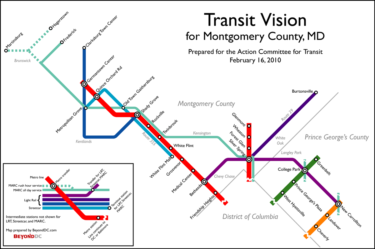
Last July, Montgomery County’s Action Committee for Transit worked with Greater Greater Washington to produce a transit vision for the I-270 corridor. Rather than spending billions of dollars on widening I-270 as the State of Maryland proposes, ACT and GGW argued that it would be better and more affordable to invest in a vigorous integrated transit network.
That was all well and good. BeyondDC agrees. But why stop with the I-270 corridor? There’s more to Montgomery County than Gaithersburg.
That in mind, ACT asked me to produce for them the following map, which expands their original 270 vision to encompass the entirety of Montgomery County.

ACT vision for Montgomery County. Click the map to enlarge.
The proposal includes:
- Extension of the Metrorail Red Line from Shady Grove north along I-370 and I-270 to MD Route 118, where it would end at Germantown Town Center. There would be one intermediate station at Quince Orchard Road, where the line crosses the CSX rail tracks.
- MARC improvements resulting in more frequent, all-day, bi-directional service to Frederick.
- A new spur of the MARC Martinsburg branch to reach Hagerstown.
- The completed Corridor Cities Transitway as light rail, with slight modifications to the route at Crown Farm and Kentlands, and a one-station extension to Clarksburg Town Center.
- The completed Purple Line, using the adopted Locally Preferred Alternative alignment.
- A new light rail line beginning at Silver Spring Metro and extending north along US-29 to Burtonsville.
- A new streetcar line beginning at White Flint Mall and running north along MD Route 355 through Rockville and Gaithersburg, ending at an expanded multi-modal Metropolitan Grove station.
- (Not shown on the map) Various bus priority and/or BRT improvements throughout the county, such as on Veirs Mill Road.
For more about their vision for Montgomery County, visit ACTfortransit.org.
Cross-posted at Greater Greater Washington.
Average Rating: 5 out of 5 based on 277 user reviews.
February 16th, 2010 | Permalink
Tags: commuterrail, lightrail, metrorail, proposal, roads/cars, streetcar, transportation

Graffiti in Georgetown, appropriate to the occasion.
Average Rating: 4.6 out of 5 based on 207 user reviews.
February 14th, 2010 | Permalink
Tags: fun
|
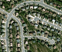
The storm was harder on people who live in places like this. |
I’ve had a lot of fun this weekend. The snow has been a novelty, has resulted in a day off work, and my ability to go about daily business has not been particularly impacted. On Friday evening I walked out my front door, went less than a block around the corner, and ate a lovely dinner at a neighborhood restaurant. On Saturday I walked four blocks to take part in a giant community snowball fight. On Sunday I went out to lunch and ran errands to CVS and the grocery store while out. I haven’t had need to use the Metro, but since I live where it runs underground, using it for longer-distance transportation was an option. I didn’t lose my power, but had it gone out I would have been able to kill time at any number of nearby cafes or bookstores.
Contrast that with the experience of my family, living out in the suburban wilds of Fairfax County. They’ve been trapped in their house since Friday, literally unable to leave. Their subdivision is two miles from the closest store and accessible only by car. Their 45-foot-wide “local” two-lane street wasn’t plowed until Sunday morning, and once it came the plow just made things worse, since it only got one lane and left a giant snowdrift between the driving lane and my family’s parked cars. Of course there have been no snowball fight-esque community events within walking distance because there is no community to speak of; population density is too low to support such a thing. Their next-door neighbors are friendly, sure, but there aren’t enough people within walking distance to support any kind of neighborhood event. Luckily, they weren’t among those who lost power. Stuck at home without TV, internet or heat would have been really miserable.
Of course, one shouldn’t base life decisions on the possibility of a freak event. A once-a-century storm isn’t necessarily a good basis from which to determine how we shape communities. Nevertheless, it’s worth noting that because of how our respective communities are shaped, a storm that has had nothing but positive effects for me has completely put my family’s lives on hold.
Average Rating: 4.8 out of 5 based on 252 user reviews.
February 8th, 2010 | Permalink
Tags: urbandesign
Two flickr photo galleries of this weekend’s blizzard. The first is simply a collection of photos from around my neighborhood. The second is from the giant snowball fight in Dupont Circle, attended by thousands and internationally famous. The individual photo descriptions within the snowball fight gallery form a narrative of the event.
Gallery: The City
Gallery: The Snowball Fight

Dupont Circle, during the snowball fight.
Update: If you prefer viewing pictures in message-board format, I combined the two galleries and posted them as a thread on SkyscraperPage, with commentary.
Average Rating: 4.8 out of 5 based on 228 user reviews.
February 7th, 2010 | Permalink
Tags: events, fun, galleries
Last year Arlington County bicycle/pedestrian planners requested volunteers to help collect counts of users on Arlington’s bike/ped facilities. They are asking for help once more. Volunteers will be asked to camp out at a specific location for two hours on February 18th or 20th, counting bikes and peds that pass by. If you are interested in participating, contact bikepedcounts@arlingtonva.us. More information is below.
Arlington County transportation programs BikeArlington and WalkArlington are looking for volunteers to help collect bicycle and pedestrian counts in Arlington County on February 18th and 20th. This regular data collection is part of a national project to document walking and cycling as modes of transportation. Collecting better data on usage and demand is essential to building long-term support for walking and cycling. More information about the national effort can be found at http://bikepeddocumentation.org
Count locations in Arlington include shared use paths, urban sidewalks and intersections, and on-road bike lanes. Many of the sites are easily accessible by Metro. Arlington transportation staff will provide training and materials. Shifts are two hours long in the morning and evening on Thursday, February 18th and Noon to 2:00 PM on Saturday, February 20th. At some locations, volunteers may be asked to observe directional information, helmet usage, and other demographic data in addition to the number of cyclists and pedestrians.
If you’d be interested in helping with this effort, email: bikepedcounts@arlingtonva.us. Arlington County’s staff coordinator will help you choose a count location and time. We’ve had up to 50 volunteers help with previous counts — let’s see if we can provide even better coverage this time.
Average Rating: 4.4 out of 5 based on 223 user reviews.
February 4th, 2010 | Permalink
Tags: bike, events, transportation