VRE carried 19, 322 passengers on Wednesday, setting a new single day ridership record for the agency. The previous record was set in February, and all 10 of the highest days have been in 2010.
Yay! Good work, VRE.
Average Rating: 5 out of 5 based on 188 user reviews.
As GGW noted, the Washington region performs very well relative to the rest of the US in terms of the overall percentage of commuters who do not drive to work alone, and the percentage who take transit to work. We are in third place in both categories behind New York (1) and San Francisco (2). However, San Francisco’s numbers do not include San Jose/Silicon Valley due to an irregularity in the way the Census defines metro areas. This is a little bit like not including anyone who works in Fairfax County in Washington’s number, and since San Jose is overwhelmingly suburban it is highly likely that if San Jose were added to San Francisco, Washington would jump up to #2 in both categories.
For biking, Washington is a dismal 14th. While the District of Columbia specifically has a very good bike share compared to most other cities, from a metropolitan standpoint all that sprawl is hurting us a lot. More people bike in metropolitan Phoenix. Ouch.
We’re 7th for walking and 8th for carpooling, which is respectable if not top tier. Interestingly, the top three carpooling cities are overwhelmingly suburban, transit-light places, while New York and other transit-heavy regions are generally near the bottom in that category. It’s actually a little odd that we rank so highly, given our high transit share.
Overall it is clear that we in the Washington region are doing a whole lot better than most American cities. Our lowest ranking is still in the top half. It’s also clear that we have a long way to go.
Average Rating: 4.5 out of 5 based on 295 user reviews.
“The Washington region is notorious for congested traffic. Is one intersection worse than all the rest? If you know of one, tell us in two sentences, where it is and what makes it the worst. Send your reply to: transportation@washpost.com”
The biggest problem intersections I experience are those where it is difficult or unsafe to cross as a pedestrian, not with the most “congested traffic.”
After all, pedestrians are the ones who’ve been getting hit in alarming numbers recently, though Halsey described the incidents as pedestrians “wandering into the path” of vehicles.
Let’s do something to erase Halsey’s windshield perspective and submit emails identifying the worst intersections for pedestrians and cyclists.
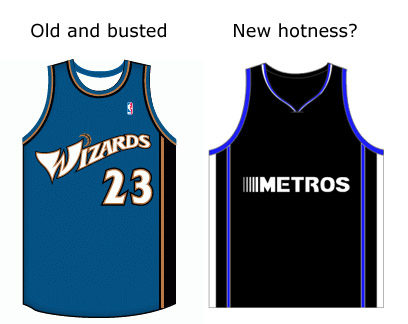
Rumor has it that the owner of the Washington Wizards is considering changing the name of the team back to the Bullets. As long as we’re thinking about new names anyway, how about this:
I’m only sort of serious. “Metros” (or should it be “Metroes”?) uniform created using JerseyRack.com.
Average Rating: 4.6 out of 5 based on 240 user reviews.
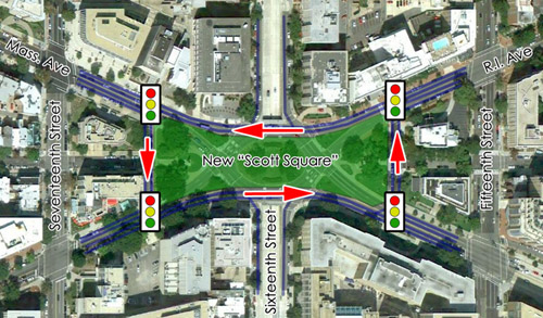
Scott Circle is the worst of downtown’s five main roundabouts. The roads are a hostile mess that pedestrians avoid at all costs, and the green spaces are chopped into such small and disconnected fragments that there’s not a useful park among them. There isn’t even a single marked crosswalk leading in to the circle itself.
In it’s current form Scott Circle is essentially a piece of highway infrastructure plopped in the middle of a walking city. It’s got to go. Luckily, there’s a workable model for what to do with it just a short way down the street.
Mount Vernon Square Lincoln Park in Capitol Hill offers a potential solution. Rather than allowing all the converging streets to cut through the park, auto traffic is routed around the square, as if the whole thing were a rectangular-shaped roundabout.
Theoretically, the same could be accomplished at Scott Circle like so:
Arrows indicate direction of traffic.
DDOT would need to introduce new stop lights, and yes, auto traffic might be slowed somewhat. But in return the city would receive a new park space that could potentially be larger than any of the circles. At the very least, Scott Circle should not be so dangerous and inhospitable for pedestrians. At best, with the right programming and a little luck, we might construct a space as elegant and loved as Dupont Circle.
Over the next few weeks I’ll be taking advantage of the reasonable temperatures, blue skies, and low humidity of autumn to prepare a series of photo essays on some of Washington’s more famous or interesting streets. Each weekend, or whenever I have the opportunity, I will prepare a photo tour of one street. I’ll pick start and end points and simply walk straight down that one corridor, without major deviation.
16th Street from Mount Pleasant to the White House is the first installment.
Last weekend I stopped by Meridian Hill Park and took some pictures. If you don’t know, Meridian Hill is so named because the United State’s Prime Meridian used to run along 16th Street, until the International Meridian Conference declared the Greenwich meridian as the world standard.
Enjoy the pictures either via the embedded flickr slide show below, or with narration in a thread at SkyscraperPage.
Average Rating: 4.6 out of 5 based on 215 user reviews.
A recent survey finds that 60% of east coast residential developers are shifting away from the suburban detached house model and towards the mixed-use urban model. Essentially, they are building less auto-oriented sprawl and more walkable infill.
This is great, and in some ways shocking news. It wasn’t very long ago that nobody was interested in building anything but 20th Century suburbia, and those few who were interested couldn’t get zoning approval or bank financing to do it. The fact that a majority of developers are both interested in and capable of building urban products really speaks to how far we have come in the field of city building since the early experiments in New Urbanism during the 1980s.
Good work, America. Maybe there’s hope for us yet.
Average Rating: 4.4 out of 5 based on 164 user reviews.
Train stations are the perfect nexus of transit and architecture geekdom. Obviously, I love them. Since I also like to make lists, and since the DC area is fortunate enough to have several excellent examples of historic depots, here is a list of what I think are the best ones:
Number 10: Manassas I’m a sucker for turrets and covered platforms, which help this otherwise unextraordinary station squeak in at number 10. Used by VRE and Amtrak.
Number 9: Chesapeake Beach Click the link and look at the picture with the station all prettied up for Christmas. Isn’t that adorable? Too bad it’s no longer a functioning depot.
Number 7: Rockville B&O Railroad architect Francis Baldwin designed a ton of great Victorian stations in Maryland. More will appear further down. Rockville’s is no longer in use as a depot.
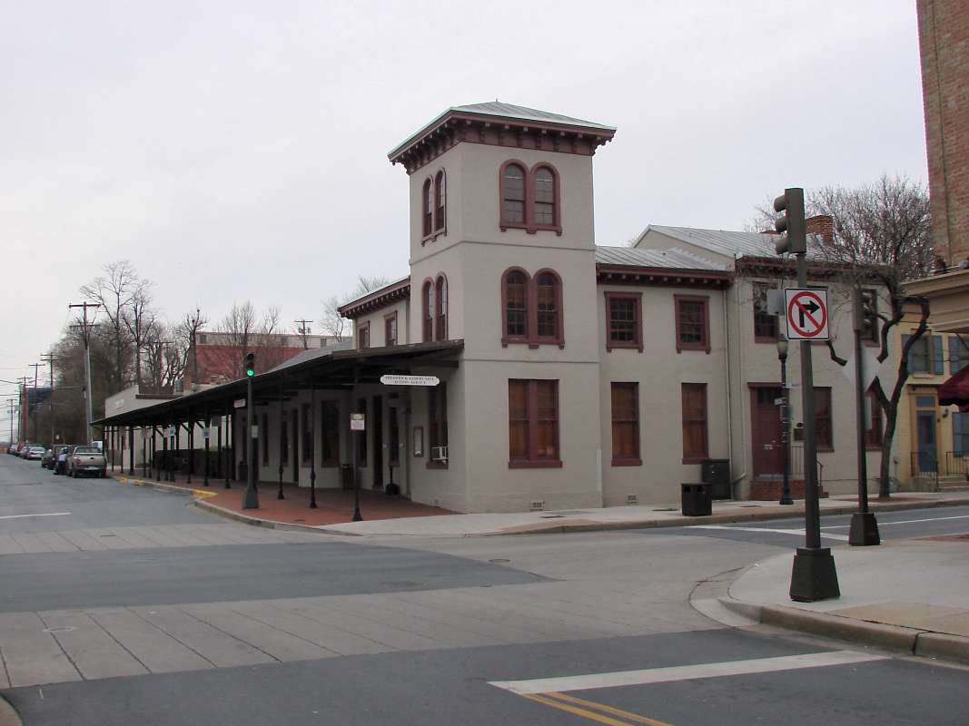
Number 6: Fredericksburg This big brick station is best remembered for its industrial looking covered platforms. We don’t have much of that steel look in DC, so it’s fun to find nearby. Used by Amtrak and VRE.
Number 5: Martinsburg It used to be common for hotels and train stations to co-locate (especially out west). This is the only local example I know of. Used by Amtrak and MARC.
Number 4: Gaithersburg Another of Francis Baldwin’s B&O depots, this one seems straight out of a fairy tale. Used by MARC.
Number 3: Frederick This vintage 1854 building is reminiscent of Washington, DC’s old B&O station, which was demolished when Union Station was built. No longer in use as a depot.
Number 2: Point of Rocks The best of Baldwin’s B&O stations, this one is just gorgeous. Used by MARC.
Honorable Mentions: Fairfax Station, Laurel, Kensington (the latter two are Baldwin stations). Also note that I excluded the Baltimore area, which has a ton of good stations as well.
Average Rating: 4.6 out of 5 based on 231 user reviews.


