|
Special Features


Image Libraries


|
|
Blog
Headed to Baltimore any time soon? If so, use this new frequent transit map, showing bus & rail routes that come at least every 15 minutes.
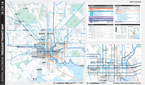
New Baltimore frequent transit map, by Marc Szarkowski for Envision Baltimore.
Compared to DC, Baltimore can be a difficult city to navigate via transit. But it’s getting easier thanks to the Charm City Circulator, weekend MARC, and the magic of frequent transit maps.
In 2011 Envision Baltimore produced an initial version of a frequent map, now they’ve updated it, and it’s better than ever.
The new map borrows heavily from WMATA’s 2012 bus maps that use a thick red line for more frequent routes. For Baltimore the thick lines are blue, but the effect and overall look is quite similar.
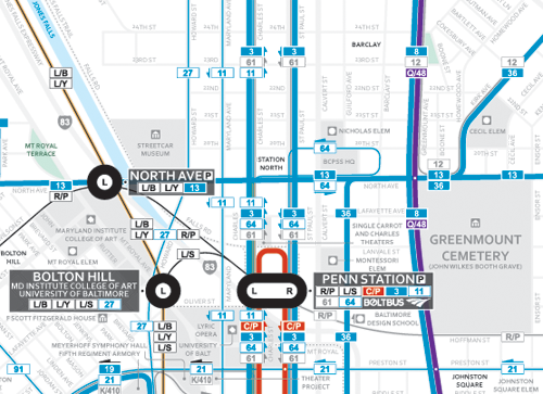
Close view of the area around Baltimore’s Penn Station. Map by Marc Szarkowski for Envision Baltimore.
I’ve added this new map to the list of all known US frequent transit maps on BeyondDC.
 Cross-posted at Greater Greater Washington. Cross-posted at Greater Greater Washington.
Average Rating: 5 out of 5 based on 172 user reviews.
October 15th, 2013 | Permalink
Tags: bus, maps, transportation

Take a look at this street scene from the recent Star Trek movie. It shows San Francisco in the year 2259.
Apparently in the universe of Star Trek, city streets will look pretty much the same 246 years in the future as they do today. Cars, a cable car, and a fancy articulated bus, all on a road with basically 20th Century lane markings. The pedestrian crossing and traffic signals are different, but it’s a wholly recognizable scene.
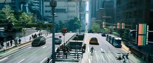
From Star Trek Into Darkness.
On the other hand, by the year 2372 things change quite a bit. These next 2 images are from the Star Trek: Voyager episode Non Sequitur, and show a street in San Francisco’s Mission District.
It’s a fully pedestrianized space, complete with a subway entrance to the fancy future Trans Francisco subway system. Very progressive overall.

From Star Trek Voyager.
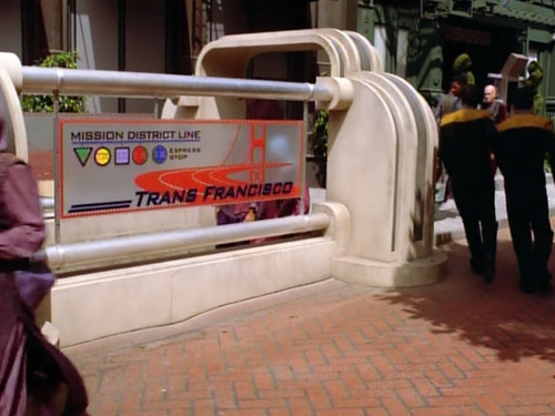
From Star Trek Voyager.
Average Rating: 4.5 out of 5 based on 296 user reviews.
October 11th, 2013 | Permalink
Tags: bus, fun, metrorail, transportation, urbandesign
The Google Maps transit layer now includes WMATA rail lines, but not bus lines.
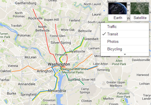
Google Maps with DC Metro. Image by Google.
Google has shown transit in many other cities around the world for years, but its data has never been complete. Some transit agencies provide detailed information, and some don’t. So while all buses and trains in San Francisco are visible, New York only shows subway lines, and Philadelphia shows nothing at all.
Google added some WMATA information back in 2011, but as far as I can tell, the rail lines didn’t show up as a visible layer until recently.
Clearly there are still some issues with the layer, though. Unless there’s a 2nd Orange Line I don’t know about.
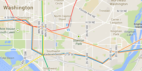
What’s that between Metro Center & Stadium-Armory? Image by Google.
Cross-posted at Greater Greater Washington.
Average Rating: 4.4 out of 5 based on 297 user reviews.
October 10th, 2013 | Permalink
Tags: metrorail, transportation
When the new Rosslyn Metro entrance opened earlier this week, it became the first in what will be an exciting string of big transit projects opening in the DC region. Still to come: Metro, MARC, streetcars, and BRT.
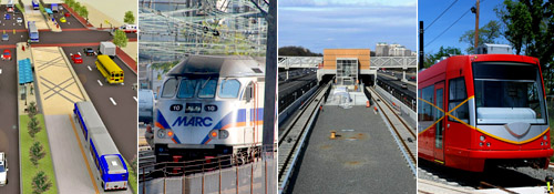
From left to right: Alexandria’s BRT, MARC, Silver Line, DC streetcar.
BRT and Metro photos from Alexandria and Fairfax County.
MARC and streetcar photos from BeyondDC.
The next big event will be on December 7, when MARC trains begin running on weekends between DC and Baltimore. MARC’s transition from a commuter railroad to a more general-purpose transit system will open up Baltimore and other parts of Maryland like never before.
After that come streetcars. Sometime in late December, or possibly January, DDOT expects to start running streetcars along H Street.
Then in February the Silver Line will open, and begin carrying passengers to Tysons Corner and Wiehle Avenue.
Finally, sometime in the spring of 2014 Alexandria will open its Route 1 transitway, marking the beginning of the first bona fide bus rapid transit line in the region.
All together, it’s the most exciting time for transit openings in the DC area since the early 1980s, when Metrorail was opening new segments every few months.
Cross-posted at Greater Greater Washington.
Average Rating: 5 out of 5 based on 180 user reviews.
October 9th, 2013 | Permalink
Tags: BRT, commuterrail, metrorail, streetcar, transportation
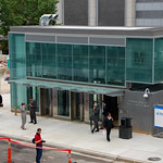
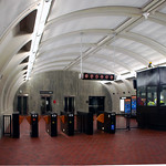
As of this morning, Metro riders can now access Rosslyn station via its new entrance on the east side of North Moore Street.
The new entrance combines 3 high-speed elevators with a new track-level mezzanine, complete with more fare gates and a manager kiosk. It expands the passenger capacity of the station, providing room for more passengers to enter and exit more quickly.
 |
 |
 |
 |
| Rosslyn’s new entrance and mezzanine. |
Cross-posted at Greater Greater Washington.
Average Rating: 5 out of 5 based on 184 user reviews.
October 7th, 2013 | Permalink
Tags: development, metrorail, transportation
The new uniform paint job taxicabs are starting to appear in DC. Twitter user @TPozen spotted one yesterday.
It’ll take years before most cabs look like this, but someday this look will be as familiar to Washingtonians as yellow-and-black cabs are to New Yorkers.
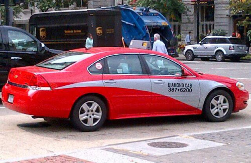
Photo by @TPozen.
Average Rating: 4.9 out of 5 based on 295 user reviews.
October 4th, 2013 | Permalink
Tags: roads/cars, transportation
The picture below is actually a bicycle. It’s a sit-down bike, with an electric-assist motor, and a car-like shell to add visibility and protection against the weather.
It’s called the ELF, and it costs about $5, 000.

Photo by Greg Raisman on flickr.
Average Rating: 4.5 out of 5 based on 279 user reviews.
October 3rd, 2013 | Permalink
Tags: bike, transportation
In 1966 when Metro planners were considering how to cross Rock Creek, one proposal suggested adding new tracks to the bottom of the Taft Bridge.
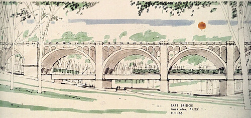
Metro Taft Bridge proposal. Image originally from WMATA, copied from Ghosts of DC.
Rock Creek presented a big problem to Metrorail. Or rather, not so much the creek itself as the deep canyon-like gulch it runs through. To cross the gulch, Metro’s subway tunnels must drop deep underground, much further than normal. Bridging over Rock Creek would’ve meant shallower tunnels on either end, and less expensive, easier to build stations at Dupont Circle and Woodley Park.
Obviously the bridge idea near happened. Metro stayed underground through the whole area, which is why Dupont and Woodley stations are as deep as they are.
For more on this interesting idea, including additional renderings of alternate designs, check out Ghosts of DC.
Average Rating: 4.6 out of 5 based on 281 user reviews.
October 2nd, 2013 | Permalink
Tags: metrorail, transportation
|
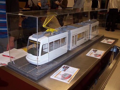
DDOT’s streetcar model. |
In response to yesterday’s story that DDOT may be able to build its 22-mile streetcar network in 5 years, spokesperson Dara Ward clarifies that timeline is only for construction, not planning.
“Given the steps still needed before construction will start, we are 2 to 3 years out before shovels hit the ground, ” says Ward. “Realistically, we’re looking at 2020-2021 for the 22-mile system to be built out.”
Such a rapid timeline is only possible because DDOT is looking to sign a private sector partner for the entire 22-mile system. Under that scenario, DDOT would pay a private company to take on responsibility to complete and run the system.
DDOT began exploring the possibility of a private partnership in 2012, and hopes to issue a Request For Proposals (RFP) sometime in 2014. Once a contractor is signed, they will proceed with detailed engineering, and then construction.
Without a private partner, Ward says it would take DDOT 17-20 years to complete the same work.
Cross-posted at Greater Greater Washington.
Average Rating: 4.8 out of 5 based on 255 user reviews.
October 1st, 2013 | Permalink
Tags: streetcar, transportation
|
Media


Site
About BeyondDC
Archive 2003-06
Contact
Category Tags:
Partners
|


