Special Features

Image Libraries

Blog

What do you get when you plot onto a single map every known light rail, streetcar, and BRT plan in the DC region? One heck of a huge transit network, is what.


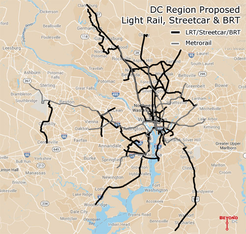
Every planned light rail, streetcar, and BRT line in the DC region. Click the map to open a zoom-able interactive version. Basemap from Google.

This map combines the DC streetcar and MoveDC bus lane plan with the Arlington streetcar plan, the Alexandria transitway plan, Montgomery’s BRT plan, and Fairfax’s transit network plan, plus the Purple Line, the Corridor Cities Transitway, the Long Bridge study, the Wilson Bridge transit corridor, and finally the Southern Maryland transit corridor.

Add the route mileage from all of them up and you get 267 miles of proposed awesomeness, not including the Silver Line or other possible Metrorail expansions.

To be sure, it will be decades before all of this is open to passengers, if ever.

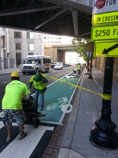
The H Street Streetcar will be the first to open this year, god willing, with others like the Purple Line and Columbia Pike Streetcar hopefully coming before the end of the decade. But many of these are barely glimpses in planners’ eyes, vague lines on maps, years or decades away from even serious engineering, much less actual operation.

For example, Maryland planners have been talking about light rail extending south into Charles County since at least the late 1990s, but it’s no higher than 4th down on the state’s priority list for new transit, after the Purple Line, Corridor Cities Transitway, and Baltimore Red Line. Never mind how Montgomery’s expansive BRT network fits in.

Meanwhile in Virginia, the Gallows Road route seems to be a brand new idea. There’s yet to be even a feasibility study for it.

Even if governments in the DC region spend the next few decades building this network, there are sure to be changes between now and the day it’s all in place. Metro’s original planners didn’t know Tysons would become the behemoth it is, and contemporary planners can’t predict the future with 100% accuracy either.

Last year the Coalition for Smarter Growth published a report documenting every known route at that time, and already a lot has changed. More is sure to change over time.

Holes in the network

With a handful of exceptions these plans mostly come from individual jurisdictions. DC plans its streetcars, Montgomery County plans its BRT, and so on.

That kind of bottom-up planning is a great way to make sure land use and transit work together, but the downside is insular plans that leave gaps in the overall network.

Ideally there ought to be at least one connection between Fairfax and Montgomery, and Prince George’s ought to be as dense with lines as its neighbors.

But still, 267 miles is an awfully impressive network. Now let’s build it.

 Cross-posted at Greater Greater Washington.


Average Rating: 4.6 out of 5 based on 186 user reviews.

May 6th, 2014 | Permalink
Tags: BRT, lightrail, maps, master planning, streetcar, transportation


1st Street cycletrack this morning.

DDOT crews are out this morning painting the new 1st Street cycletrack green.

Usually DDOT reserves green paint for spots where cars and bikes cross paths, as a reminder to drivers and cyclists to watch for each other. For 1st Street, however, the green paint is going down for long stretches of pavement, to make it totally clear to drivers that the bike lane isn’t for parking cars.

Arlington is also starting to use green paint to dissuade illegal parking. The bike lanes on South Hayes Street in Pentagon City are green for long stretches too.

In other cycletrack news, as of yesterday evening the M Street bike lanes are just about ready too. The striping looks done, but the bollards aren’t up yet.

Average Rating: 4.9 out of 5 based on 212 user reviews.

May 2nd, 2014 | Permalink
Tags: bike, transportation


This is what 16th Street looks like on a typical weekday morning. Good luck navigating it, as either a bus rider or car driver.

Streamlining this mess of buses with a transit lane could speed up traffic for everyone.


Bus bunching on 16th Street. Photo by Kishan Putta.

More than half of all people traveling on 16th Street at rush hour use the bus. It’s DC’s most successful bus corridor. But that success comes with a down side: There are so many buses that they bunch into bus traffic jams.

That’s a problem for both bus riders and car drivers. Instead of being able to catch a bus every two minutes, transit riders have to wait a long time for a clump of several buses to arrive all together, almost like a single long train. Most of the buses are full, but eventually one near the end of the “train” may have enough room for more passengers to board.

That’s inefficient, slows down the line, reduces overall capacity, and adds unnecessary operating expense.

And it’s just as bad for car drivers. Imagine being stuck behind that clump of buses in a car. That’s a traffic jam, no two ways about it.

And this is why a bus lane on 16th Street could potentially help everyone. If that bus traffic jam can be streamlined into a bus lane, buses will move faster and stay better organized, and cars won’t have to contend with roaming clumps of disorganized buses spilling into every lane.

Theoretically DDOT should be able to add a bus lane without sacrificing any car lanes. But even if sacrificing a car lane is necessary, that still may improve car traffic simply by virtue of eliminating bus jams.

It’s worth trying.

 Cross-posted at Greater Greater Washington.


Average Rating: 4.8 out of 5 based on 181 user reviews.

May 1st, 2014 | Permalink
Tags: BRT, bus, roads/cars, transportation


Media


Site
About BeyondDC
Archive 2003-06
Contact

Search:

GoogleBeyondDC
Category Tags:

Partners
 
  Greater Greater Washington
 
  Washington Post All Opinions Are Local Blog
 
  Denver Urbanism
 
  Streetsblog Network


BeyondDC v. 2013d | Email | Archive of posts from 2003-2006