|
Special Features


Image Libraries


|
|
Blog
|
Image from WMATA. |
Yesterday morning WMATA took control of the Silver Line from construction teams, declaring the line has reached “operational readiness.” Metro now begins a 90-day testing and training period, prior to opening service this summer.
The Metropolitan Washington Airports Authority (MWAA) owns the Silver Line and has been in charge of construction. Yesterday’s action officially transferred day-to-day control, management, and operations of the line to WMATA.
Following testing, opening day for passengers should come a little before or after the 90-day period runs out. The WMATA Board will set the exact date. If testing goes well, August seems the most likely bet.
The Silver Line was originally intended to open in December 2013, but construction delays and technical adjustments have pushed it out to this summer.
But now Metro officials think the delays are over. According to Metro Deputy General Manger Rob Troup, “We would not have reached this [point] if we were not confident of being able to do the testing within the time frame.’’
Average Rating: 4.6 out of 5 based on 293 user reviews.
May 28th, 2014 | Permalink
Tags: metrorail, transportation

Capping an underground parking garage with a public park is such a nice idea. It’s a shame DC’s most prominent example is such a terrible park.
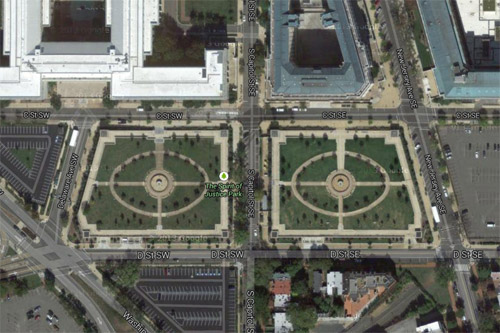
Spirit of Justice Park. Image from Google.
The South Capitol parking crater is undeniably one of DC’s most inappropriately underused plots of land. It’s 6 complete blocks of parking lots, all in a cluster mere steps from the US Capitol.
By all rights these blocks should be active and vital parts of downtown DC. Instead, they’re under the jurisdiction of the Architect of the Capitol, and thus off-limits to the normal rules of city building. In the vacuum of capitol complex land management, vast parking lots for Congresspeople and their staffs are a higher priority than housing, amenities, or attractive streetscapes.
So it’s nice that federal planners at least tried to spruce up this neighborhood-sized sea of asphalt with Spirit of Justice Park, a cap atop a two-block section of parking that’s covered with green space.
Unfortunately, it’s a lousy park.
The biggest problem is that rather than sink the parking below grade, the park is raised a level above the sidewalk. As a result, many people only see an imposing wall, and have no idea the park behind it even exists.

The sidewalk in front of the park. Image from Google.
People who actually want to enter and use the park must find one of only four entrances over the entire two-block area. Of the four entrances, two face the congressional office buildings and one faces the street between the two park blocks (though you can’t walk between them directly), leaving only a single entrance on the south side facing away from the capitol complex towards the public city.
Meanwhile, there are no visible entrances facing east nor west.
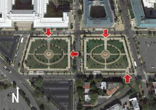
Entrances to Spirit of Justice Park. Image originally from Google.
That’s not the only problem. With a parking garage directly beneath the grass, the park’s soil is too shallow to support trees large enough to provide shade or protection against wind. The park is uncomfortably hot in the summer, and cold in winter.
Finally, management apparently only cares about capitol complex workers, because the fountains at the center of each block are switched off over the weekend.
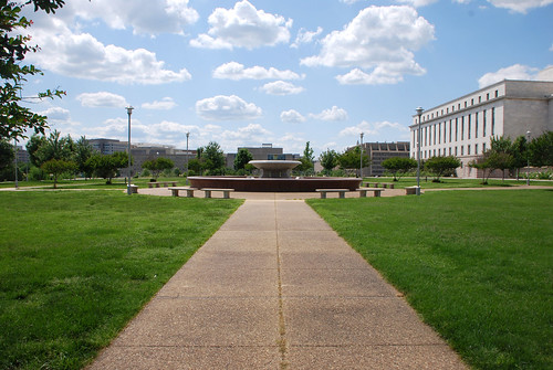
Small trees and a dry fountain hidden behind a wall. No people.
The overall message is that the public is barely tolerated in this park, not really welcome, and certainly not a priority. As a result, the public mostly stays away.
A park that’s not used is a useless park. We can do better.
 Cross-posted at Greater Greater Washington. Cross-posted at Greater Greater Washington.
Average Rating: 4.4 out of 5 based on 209 user reviews.
May 27th, 2014 | Permalink
Tags: government, parks, urbandesign
With DC’s M Street and 1st Street cycletracks on the ground, the central city network of protected bike lanes is starting to actually look like a network.
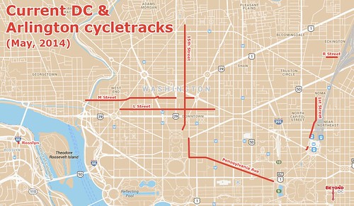
Base map from Google.
This map shows every cycletrack in town. In addition to M Street and 1st Street, there’s L Street, Pennsylvania Avenue, good old reliable 15th Street, and the diminutive R Street lane near the Metropolitan Branch Trail.
For the sake of completion the map also shows Rosslyn’s super tiny cycletrack, which exists mainly to access a popular Capital Bikeshare station.
Between DC’s proposed 70 mile cycltrack network and plans coming together in South Arlington, hopefully future iterations of this map will look even better.
Notice anything missing or wrong?
Average Rating: 4.7 out of 5 based on 212 user reviews.
May 21st, 2014 | Permalink
Tags: bike, maps, transportation, Uncategorized
|
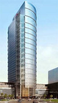
Proposed Capital One skyscraper. Image from Fairfax. |
Last Friday, Fairfax officially approved a new headquarters tower for Capital One in Tysons Corner. At 470 feet tall the new building will be the tallest in the DC region after the Washington Monument.
If that news sounds familiar, it’s because in May of 2013 developers proposed a 435 foot tall building, then the tallest in the region yet. And when Alexandria approved a 396 foot tall tower, that also would’ve been the tallest. Meanwhile, Arlington’s 384 foot tall 1812 North Moore tower recently finished construction, officially taking over the title of region’s tallest skyscraper (for now).
There may not be an explicit competition, but the fact is undeniable: Northern Virginia’s in a full-on skyscraper rivalry. And Tysons is pulling insurmountably ahead.
At 470 feet tall, this new Tysons building will be the first in the DC region to officially eclipse Richmond’s tallest, the 449 foot tall Monroe Building. Baltimore and Virginia Beach each have towers above 500 feet, often considered to be the breaking point for a true skyscraper.
Cross-posted at Greater Greater Washington.
Average Rating: 4.6 out of 5 based on 256 user reviews.
May 20th, 2014 | Permalink
Tags: architecture, development
Least controversial statement ever written on BeyondDC: Rock Creek Park is a nice amenity.
Average Rating: 4.5 out of 5 based on 294 user reviews.
May 19th, 2014 | Permalink
Tags: galleries, parks
|

Downtown DC. |
According to a US Census report, the District of Columbia’s daytime population, including commuters, swells to over 1, 000, 000. The difference between DC’s day and night populations is second greatest in the US.
The report dates from 2010 so the numbers are surely a bit different today. With DC’s (then) nighttime residential population of 584, 400, its 1, 046, 036 daytime population represents a 79% increase. Among US counties, only New York County (Manhattan) has a larger percentage increase.
Arlington looks much the same. Its 26% increase in daytime population is 13th largest nationally. That’s higher than San Francisco on the list.
At the other end of the spectrum, two DC suburbs top the list of places with decreased daytime population. Dale City and Centreville in Northern Virginia both drop by over 40%, making them America’s ultimate bedroom communities. Montgomery County’s Germantown is Maryland’s highest entrant, and clocks in at #20 with a decrease of 31%.
Part of the explanation for this is simply where boundaries are drawn. For example, even though Houston has a large downtown with many commuters, it doesn’t appear on the increased daytime population list because the City of Houston annexed so many of its suburbs that more of its commuters still technically live within the city limits. Likewise, Houston’s Harris County is gigantic and more or less envelopes the entire metropolis, so there’s little difference at the county level either.
Geographically smaller jurisdictions in large metropolitan areas are disproportionately more likely to show up in this data. So it’s not a great comparison of commuting patterns across different metropolitan regions. But it’s nonetheless interesting to know.
Cross-posted at Greater Greater Washington.
Average Rating: 4.9 out of 5 based on 228 user reviews.
May 16th, 2014 | Permalink
Tags: demographics
DC is adding green-painted bike lanes left and right, which is great news, but the District is way behind other cities in another type of painted pavement that’s beginning to sweep across America: red-painted bus lanes.
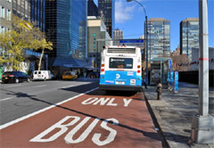 |
 |
Red-painted bus lanes in New York (left) and San Francisco (right).
Photos from NYDOT and Reddit user freedenizen. |
The idea behind red-painted bus lanes is exactly the same as green for bikes. It’s a clear signal for car drivers to stay out, so there’s no excuse for illegally driving in a non-car lane. San Francisco even uses dashed red paint to indicate where cars are allowed to cross bus lanes, exactly how DC uses green dashes for crossings.
In addition to New York and San Francisco, red-painted bus lanes will also soon pop in Seattle and Chicago.
Why not here? For one, obviously, DC doesn’t have many bus lanes. Plans for bus lanes on 16th Street and H & I Streets are stalled, and although the K Street Transitway is moving forward as part of the crosstown streetcar, there’s no opening date in sight.
But DC does have one bus lane on the ground right now that could benefit from red paint. 7th Street NW in Chinatown, directly in front of the Verizon Center. 7th Street has signs and pavement markings indicating it’s a bus lane, but it’s never enforced, and so many cars use the lane that you’d never know they’re not supposed to be there.
If DDOT is serious about keeping the 7th Street bus lane then red paint could be a way to make it work. If not, paint is still worth exploring on 16th, H & I, and K, if bus lanes there ever actually happen.
Average Rating: 4.7 out of 5 based on 267 user reviews.
May 15th, 2014 | Permalink
Tags: bike, BRT, bus, transportation
A global cycling heat map from the fitness app Strava shows where people are exercising by bike. It’s a useful tool to chart the most popular bike trails, but the data skew heavily towards wealthier recreational cyclists and away from transportation and less affluent areas.
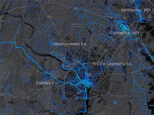
Stava cycling heat map for the DC region.
Strava is an exercise app for smartphones that uses GPS to track users’ cycling and jogging routes. Fitness enthusiasts use it to chart their running or cycling times, and measure performance over time. Since the company has billions of data points from users all over the world, it was easy to plot it all onto a map.
The resulting global heat map is a fascinating look at the most popular trails. For our region, it’s easy to see long-distance regional trails stand out, especially in Fairfax, Arlington, Montgomery, and Howard Counties.
But while this is interesting stuff, it’s unfortunately not very useful for urban transportation planning. Since 100% of Strava users care so much about speed that they’ve downloaded an app to measure it, and are wealthy enough to have a smartphone, the data skews seriously in favor of recreational cycling among affluent populations.
On the flip side, it seriously undercounts cyclists who bike as transportation simply to get from point A to point B. Likewise, it seriously undercounts lower income populations.
To prove the point, merely compare the trails on the west side of the DC region to those on the east side. Or compare the bright blue suburban trail network in Columbia, MD with the much more limited cycling apparent in central Baltimore. The places affluent people bike on the weekend stand out, while others sink to the background.
So this is neat info, beautifully presented, with practical applications to regional trail planning and parks planning. But for urban bike lanes, it’s no substitute for hard local data.
Cross-posted at Greater Greater Washington.
Average Rating: 4.5 out of 5 based on 175 user reviews.
May 12th, 2014 | Permalink
Tags: bike, maps, transportation
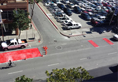
Arlington is deploying bike “fix-it” repair and maintenance stands at Metro stations around the county. The stands include all the tools cyclists need to change a flat tire, add air, or adjust brakes and derailleurs. Just hang your bike on the kiosk and go to work, free of charge.
So far there are stands at the bike parking stations in Clarendon and Ballston. Watch for one soon in Pentagon City.
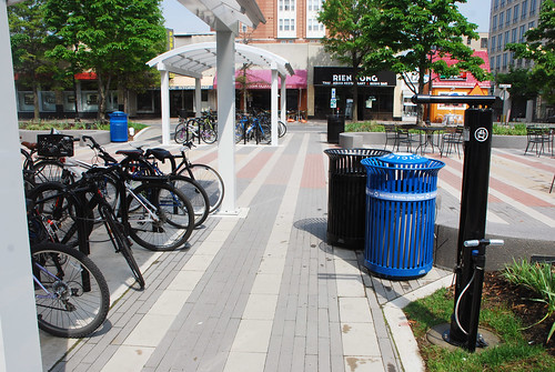
Clarendon bike fix-it stand, on the right.
Cross-posted at Greater Greater Washington.
Average Rating: 4.5 out of 5 based on 166 user reviews.
May 9th, 2014 | Permalink
Tags: bike, transportation
Take a look at this cycletrack in Boulder, CO. It includes parking stops along with the usual flexposts, thus providing strong protection against cars.
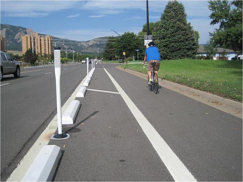
Baseline Road cycletrack, Boulder, CO. Photo from the City of Boulder.
This particular cycletrack is on Baseline Road, a busy suburban arterial with relatively high-speed car traffic. It’s easy to understand why cyclists would want more protection there than on a slower-speed urban street.
This design is a stark contrast from the more urban cycletrack in downtown Boulder, where a lush (and expensive) landscaped median provides the protection from cars.
Between the two designs, one can see the range of options.
13th Street cycletrack, Boulder, CO. Photo from BeyondDC.
Cross-posted at Greater Greater Washington.
Average Rating: 4.9 out of 5 based on 167 user reviews.
May 7th, 2014 | Permalink
Tags: bike, transportation
|
Media


Site
About BeyondDC
Archive 2003-06
Contact
Category Tags:
Partners
|