|
Special Features


Image Libraries


|
|
Blog
I’m with family near Albany, New York until December 30ish. With any luck, the next post you see here will be for the opening of the H Street streetcar.
With luck.
Yes, I’ll believe it when I see it too.
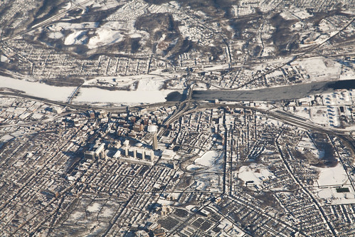
Albany. Photo by Doc Searls on Flickr.
Average Rating: 5 out of 5 based on 165 user reviews.
December 23rd, 2014 | Permalink
Tags: in general

As of last week, rubber parking stops called “Park-Its” now protect a half block segment of the Pennsylvania Avenue protected bikeway, between 9th and 10th Streets NW.
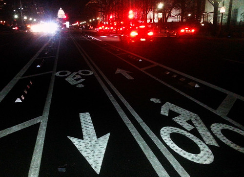
The Park-Its are intended to protect cyclists from drivers making illegal U-turns across Pennsylvania Avenue’s median bike lanes.
DDOT crews installed the first Park-Its yesterday around 11:00 am. Workers will add more in the coming days, until Park-Its line the bikeway for the two block stretch from 9th to 11th.
Full installation of Park-Its all along Pennsylvania Avenue could eventually happen, but for now DDOT hopes to determine if this initial installation works. According to DDOT’s Darren Buck, the Park-Its on 1st Street NE sometimes pull up out of the pavement.
Park-Its succeed the zebras that DDOT installed in 2013, but which proved only partially effective. For now, the zebras between 12th and 13th Streets will remain in place.
 Cross-posted at Greater Greater Washington. Cross-posted at Greater Greater Washington.
Average Rating: 5 out of 5 based on 255 user reviews.
December 22nd, 2014 | Permalink
Tags: bike, transportation
Remember #bikeinbloom, when Capital Bikeshare dressed one of its bikes up in cherry blossom regalia? Every Christmas, Amsterdam does the same thing with one of its famous streetcars.
Amsterdamers call it the “kersttram”, or “Christmas tram.”
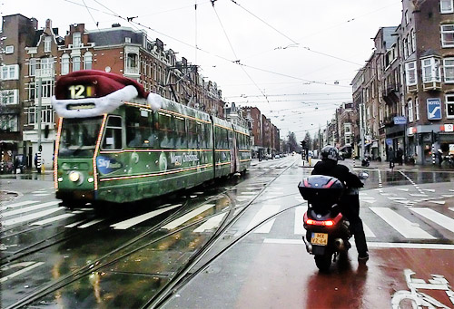
Photo from Alexander Meijer on Flickr.
Amsterdam isn’t alone. Other cities around the world partake in the same fun with their own trams. Among them: Budapest, Zurich, and San Francisco.
How about it, DDOT? Maybe next year, when H Street is finally up and running?
Cross-posted at Greater Greater Washington.
Average Rating: 4.8 out of 5 based on 188 user reviews.
December 18th, 2014 | Permalink
Tags: fun, streetcar, transportation
A public art installation on San Francisco’s Market Street will add animated lights following the movement of subway trains running directly below.
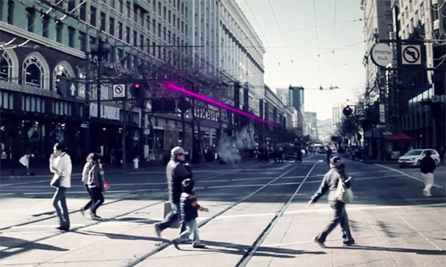
Image from Illuminate The Arts.
The project is called “LightRail, ” and according to its sponsors it will be the world’s first “subway-responsive light sculpture.”
Two LED strings will stretch above Market Street for two miles through downtown San Francisco. Using real-time arrival data, the strings will visualize movement of BART and Muni trains directly underneath the street.
Sponsors hope LightRail will open in 2015, and will remain in place until at least 2018. If it proves popular, officials may decide to keep it up longer.
Without a doubt, this is one of the coolest public art projects I’ve ever seen.
Cross-posted at Greater Greater Washington.
Average Rating: 4.5 out of 5 based on 289 user reviews.
December 17th, 2014 | Permalink
Tags: fun, lightrail, metrorail, transportation
The water main break that temporarily flooded parts of Metrorail this morning was painful for commuters. These photos from Metro’s Twitter account show just how serious the flood became.
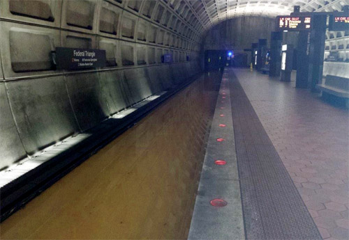
All photos from WMATA.
Metro’s third rail is eight inches high. It was fully covered by water.
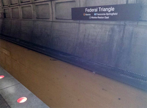
The flood drained after DC Water shut off water flow. As the water receded, the tracks slowly became visible once more.
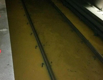
Hopefully that’s not an experience we’ll have to go through again any time soon.
Cross-posted at Greater Greater Washington.
Average Rating: 4.7 out of 5 based on 169 user reviews.
December 16th, 2014 | Permalink
Tags: metrorail, transportation
For most its history, Capital Bikeshare’s busiest individual station has been at Dupont Circle. Not anymore. As of this summer, the Lincoln Memorial station is the new king.
This animation shows trips coming and going to the Lincoln station.
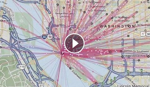
Video from Mobility Lab.
Capital Bikeshare’s most recent usage data is from its third quarter report, and covers the period from July 2014 through September.
During that period, the station at Massachusetts Avenue and Dupont Circle NW (historically the busiest) served 42, 237 total trips. That’s an average of 459 per day.
But the Lincoln Memorial station served 44, 177 total trips over the same period, averaging 480 per day.
Follow the tourists
Dupont Circle is usually the busiest station because it combines a nearly perfect storm of bikeshare ridership ingredients: Lots of nearby bike lanes, a Metro station feeding transfers, high job and population density, and a busy nightlife. It’s hopping at nearly all hours.
The Lincoln Memorial has virtually none of those things, but does have its own advantages. It’s one of the most popular parts of the National Mall, and is a far walk from convenient transit. For tourists who don’t want to drive and aren’t part of a group with a tour bus, bikeshare is an obvious way to access the Lincoln.
The animation shows how tourists drive most of the station’s usage. Blue lines show trips from regular members, while red lines are trips from short term users more likely to be tourists. Aside from a spike of blue around rush hour, the animation is a flood of red lines.
It probably won’t last
Will the new champion hold its spot, or will the Lincoln’s dynasty prove fleeting?
Tourists flock to Washington in the summer, but there are far fewer of them in the winter. When data for autumn comes out, it’s extremely unlikely the Lincoln will still be the busiest station. Odds are that honor will return to Dupont.
And next summer, bikeshare will face added competition from the new DC Circulator route scheduled to run along the National Mall beginning in 2015.
So this may well be the Lincoln’s only moment in the sun. It will be interesting to follow.
Cross-posted at Greater Greater Washington.
Average Rating: 4.4 out of 5 based on 240 user reviews.
December 12th, 2014 | Permalink
Tags: bike, transportation
In most of the United States, the maximum speed limit is somewhere between 65 and 75 miles per hour. What about the rest of the world? This map tells you.
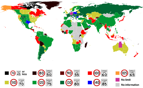
Maximum speed limits around the world. Map from Reddit user worldbeyondyourown.
In the eastern US, most states top out with maximum speed limits of 70 miles per hour. Out west, most states allow 75, and a handful go even higher than that.
Texas has the highest speed limit in the western hemisphere, at 85 miles per hour. On the other end of the spectrum, no road in Canada’s province Nunavut has a limit above 45 miles per hour.
Germany’s Autobahn famously has no maximum speed limit, but it’s not the only place in the world to hold that distinction. Australia’s Northern Territory is also speed limit free. But don’t try racing down roads in Bhutan, where the maximum limit is no higher than 45.
What else jumps out?
Cross-posted at Greater Greater Washington.
Average Rating: 4.4 out of 5 based on 187 user reviews.
December 11th, 2014 | Permalink
Tags: maps, roads/cars, transportation
Is there an urbanist in your life? Of course there is; you’re reading this blog. Here are a bunch of great gift ideas to satisfy your favorite urban geek, or maybe add to your own wish list.
 |
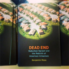 |
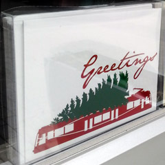
| DC streetcar holiday cards from Analog, and Ben Ross’ book Dead End. |
There are tons of great genre gifts available in stores and online. But special mention goes out to two that come from members of our own urbanist blogging community:
Ben Ross’ book Dead End
Ben Ross is a frequent GGW contributor and a prolific author. His book Dead End: Suburban Sprawl and the Rebirth of American Urbanism is perhaps the most cogent explanation ever written about the motivations of community activists. Dead End is $26 new from Amazon.
DC streetcar greeting cards
Get your correspondence on with DC streetcar themed Christmas cards, which my wife Melissa makes for her Brookland store Analog. A set of 8 cards is $14, available online, at the shop, or at upcoming pop-up markets in Rosslyn and Silver Spring.
More great options
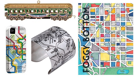
White house tree ornament, Metro map phone case and bracelet, DC neighborhood wall art.
This year’s White House Christmas tree ornament is an old style train ($24).
Local graphic designer Cherry Blossom Creative makes a series of colorful DC neighborhood wall prints ($20).
WMATA has an official DC Metro Store that sells a wide variety of Metro-themed products, including iPhone cases ($39), bracelets ($32), mugs ($12), model buses ($35), and more. Or if you’re looking for something more functional, how about a SmarTrip card loaded with fare money.
Still need more? Everything from last year’s gift guide would still work, Urbanful has an extensive marketplace, and Etsy is filled with DC-themed gifts.
COPY ONTO BDC
Cross-posted at Greater Greater Washington.
COPY ONTO GGW
 Cross-posted at BeyondDC. Cross-posted at BeyondDC.
Average Rating: 4.9 out of 5 based on 248 user reviews.
December 10th, 2014 | Permalink
Tags: events, in general
The most successful bikeshare systems in the world have dense networks with stations every few blocks, according to bikeshare guru Jon Orcutt. That suggests that as Capital Bikeshare expands, the agency should focus on adding small infill stations rather than adding more docks to make existing stations bigger.
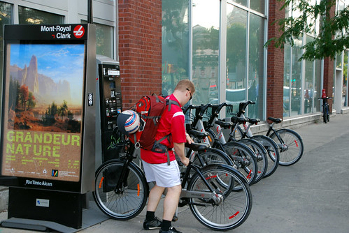
Bikeshare station in Montreal with only seven docks.
More stations are better
In a recent Streetsblog interview, Orcutt points out there’s a clear (and probably causal) correlation between bikeshare station density and bike usage. He cites the Institute for Transportation & Development Policy’s (ITDP) bikeshare planning guide, which bluntly states “increasing station density will yield increased market penetration.”
Simply put, systems with denser networks get more riders per bike per day.
That makes sense. Most bikeshare trips cover short distances, so the closer stations are to cyclists’ final destinations, the better. Conversely, it’s a major disincentive if riders have to walk more than a block or two to get to a station, and dockblocking is much more painful when the next closest station is many blocks away instead of right around the corner.
Since there are destinations on every block, the ideal bikeshare network would have stations on every block. That’s probably not practical even in the densest part of the city, but the best bikesharing networks seem to be those that come the closest. ITDP’s guide says to shoot for 10-16 stations per square kilometer.
And though Capital Bikeshare is one of America’s leading bikeshare systems, CaBi and nearly all its American peers lag world leaders in station density. That strongly suggests American bikeshare networks aren’t attracting as many riders as they could.
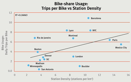
Image from the Institute for Transportation and Development Policy.
Politics matter, especially in the Washington region
With distinct clusters of stations in DC, Maryland, and Virginia, Capital Bikeshare is one of the most spread out systems in the world. But while that undeniably reduces the number of riders per bike, it clearly benefits CaBi politically, and therefore financially.
We’re lucky in this region to have a strong regional consensus on the benefits of bikesharing. It’s not just something that DC and Arlington do, which the suburbs grudgingly ignore. Alexandria and Montgomery take part. Fairfax and Prince George’s soon will. It’s a regional network that benefits everyone, and everyone has a stake in its success.
So it’s OK to spread stations out into distinct clusters in multiple jurisdictions, or even multiple wards of the same jurisdiction. But within each cluster, a large number of small stations is better than a handful of large ones.
There’s a catch
If smaller stations are better, why does Capital Bikeshare expand existing ones so often, rather than pour those resources into new station locations?
Simple: Because that would cost more.
Bikeshare stations are prefabricated. They come in basically three components: The kiosk section with the map and credit card terminal, snap-on docks, and the bikes themselves.
Each individual bikeshare station needs all three components, including the kiosk section. But expanding an existing station only takes more docks and more bikes, no kiosk. Thus, by expanding existing stations, CaBi reduces the need to buy expensive kiosk components. They can put out slightly more bikes and more docks with fewer, bigger stations.
Peak capacity versus peak access
Maximizing the number of bikes and docks is important too. The key question is whether it’s more important for a bikeshare agency to maximize peak capacity or peak access.
Putting out the most possible docks and bikes at a smaller number of stations makes the system more useful for rush hour commuters, but less useful for other trips. On the flip side, a system with slightly fewer docks but more stations would be less convenient for commuters, but would put more of the city within reach of a station.
Different bikeshare systems might rightly prioritize different expansion models at different times. But Capital Bikeshare is one of the more commute-oriented large systems in the world. It may be time to think about maximizing infill.
Cross-posted at Greater Greater Washington.
Average Rating: 5 out of 5 based on 224 user reviews.
December 4th, 2014 | Permalink
Tags: bike, proposal, transportation
These stills from the four minute film Wanderers beautifully show what human civilization might look like with colonies on Mars, in the asteroid belt, and on the moons of Jupiter, Saturn, and Uranus.
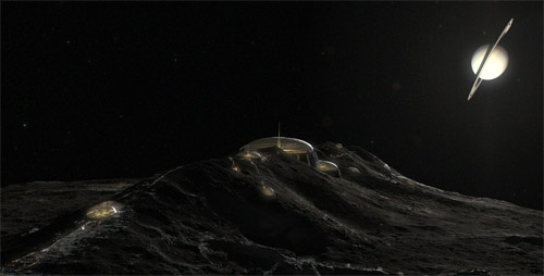
Cities on Saturn’s moon Iapetus. All images from Erik Wernquist’s Wanderers.
Though stunning, these images are not mere fantasies. They’re based on real scientific ideas about what a spacegoing civilization would likely look like, given foreseeable future technology.
The film is by Swedish artist Erik Wernquist, who draws inspiration from hard sci-fi author Kim Stanley Robinson’s Red Mars trilogy, as well as his novel 2312.
The first image, above, shows a series of domed settlements on Saturn’s icy moon Iapetus. Iapetus has a giant equatorial ridge that runs around the entire moon like an actual physical equator. The views of ringed Saturn from atop Iapetus’ ridge would be among the most dazzling in the solar system.
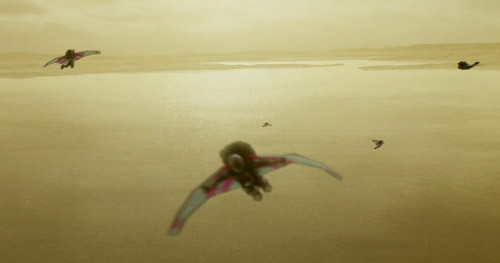
Bird suit fliers on Titan.
This second image shows another moon of Saturn, Titan, where the human-powered transportation equivalent to bicycling would be a bird suit.
Titan is larger than the planet Mercury, has rivers and oceans of liquid methane, and an atmosphere thicker than Earth’s. Its combination of thick atmosphere and low gravity would make it possible for humans to fly using nothing but strapped-on wings.

“Terraruim” colony, from a hollowed cylindrical asteroid.
This third image shows an O’Neill cylinder colony, or what Wernquist and Robinson call a “terrarium.” It’s a cylindrical hollowed out asteroid that astronauts have filled with an atmosphere and terraformed with a habitable landscape.
That may seem like a lot of effort, but for a spacegoing civilization asteroids offer many advantages, especially for transportation purposes. Their extremely low gravity makes launches and landings much easier than any planet or moon, while they still have enough raw materials to mine and export.

Martian space elevator.
This last image shows a space elevator ferrying people and goods between orbit and a brightly lit metropolis on the surface of Mars.
Space elevators would have to be tens of thousands of miles long, but would negate the need for expensive chemical rockets, making space vastly easier and cheaper to access.
They’re exactly the sort of revolutionary transportation system that could completely change how humanity organizes itself. Prosperous port cities would be sure to form at the base of any elevators ever built, like futuristic New Yorks at the mouth of a celestial Hudson River.
Amazingly, space elevators are not that far-fetched. Scientists understand elevators’ physics well enough that they may be buildable within the next century.
Be sure to watch the four-minute film, and check out Wernquist’s gallery for more of these beautiful images.
Cross-posted at Greater Greater Washington.
Average Rating: 4.4 out of 5 based on 261 user reviews.
December 2nd, 2014 | Permalink
Tags: fun, master planning, proposal, transportation
|
Media


Site
About BeyondDC
Archive 2003-06
Contact
Category Tags:
Partners
|


