Wide suburban highways lined with big boxes and strip malls aren’t usually places one finds protected bikeways. But Stringtown Road in Grove City, Ohio is such a place. Check it out:
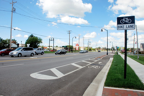
Stringtown Road.
Since a curb protects the bikeway from the road, it’s technically a sidepath, a sidewalk that’s for bikes instead of pedestrians.
And as you can see in photos from Google Street View, it’s nicer than riding in the street with fast-moving cars, but it’s still not exactly pleasant.
Huge curb cuts interrupt the bikeway, so cars don’t need to slow down much before pulling into the giant parking lots lining the road. There’s certainly a risk that careless drivers will turn without watching, and hit people on bikes.
But that’s a risk that will exist for any car-oriented highway. At least this one puts the bike lane front and center, just about as visible as it can be.
There are some sidepaths along large roads in the DC area, like Route 50 in Arlington or along Benning Road near RFK, but those aren’t commercial highways lined with shops, and their sidepaths aren’t right against the curb like Stringtown’s. This particular layout is pretty unusual.
As more and more suburban communities evolve to become more multimodal, experiments like this will help everyone around the country understand what works and what doesn’t. Grove City is near Columbus, where it’s not the only suburb experimenting with urban retrofits.
What do you think? Will this design work? Comment at Greater Greater Washington to talk about it.
 Cross-posted at Greater Greater Washington.
Average Rating: 5 out of 5 based on 231 user reviews.
March 27th, 2015 | Permalink
Tags: bike, transportation, urbandesign
An outside review of the H Street Streetcar found no fatal flaws in the project that would prevent it from opening.
The American Public Transportation Association’s (APTA) peer review of the streetcar on “whether there’s a pathway to passenger service” is in, and the answer is yes, the streetcar can open.
In its letter to DDOT, APTA recommends a list of additional training and new procedures for the streetcar, but none appear to be major problems. The list includes more training for maintenance staff, reviewing operations and maintenance procedures, and augmenting DDOT staff with more experienced personnel.
DDOT is now analyzing the results and establishing a schedule to complete the recommendations.
There is still no opening date for streetcar passenger service, but it appears likely that question is now one of “when” rather than “if.”
Cross-posted at Greater Greater Washington.
Average Rating: 4.7 out of 5 based on 199 user reviews.
March 20th, 2015 | Permalink
Tags: streetcar, transportation
The northern lights, aurora borealis, are usually only visible near the Arctic Circle. But every once in a while, when conditions are perfect, they make an appearance as far south as DC. I caught a glimpse early Wednesday morning.
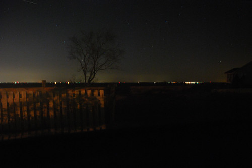
Aurora over Chesapeake Bay on Wednesday morning.
On Tuesday news spread that a heavy solar storm was hitting Earth, and producing some of the strongest aurora in years. Maybe strong enough to see from DC.
Since the sky was clear, the moon below the horizon, and conditions perfect, my wife and I booked a Zipcar to the clearest northerly view I could think of: The northern tip of Kent Island, across the Bay Bridge, in the middle of the Chesapeake.
And there was the aurora. Barely visible, but there. Dim green flashes floated low against the horizon, flowing in great fast waves from east to west. It was nothing like the huge curtains of light you see in the famous pictures (we’re too far south for that), but it was unmistakable nonetheless.
How you can see them next time
Aurora are sometimes visible from DC’s latitude. But they may never be visible from inside the District of Columbia, because this far south they appear very dim, and only close to the northern horizon. To see them, find an extremely dark north-facing vantage point, with a clear sight of the horizon.
If there are street lights turned on or trees blocking the horizon, you probably won’t see them even if conditions are otherwise right.
Since we live in Northeast, we decided Kent Island would be ideal. It’s about an hour drive east of DC, assuming no traffic—usually a safe assumption after midnight.
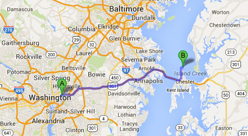
Route to Kent Island. Map from Google.
You will need a car to get there. And since news of likely aurora this far south typically only comes the day of the event, you won’t have much time to plan ahead. But in the age of car-sharing, even a car-free urbanite can get it done.
Cross-posted at Greater Greater Washington.
Average Rating: 4.4 out of 5 based on 231 user reviews.
March 19th, 2015 | Permalink
Tags: fun, galleries, in general
Washingtonians hoping to catch a bus in 1975 consulted this friendly-looking hand-drawn map. Charming as it may be, the map has no lines. Rather, designers wrote the name of each bus route over and over along its path through the city.
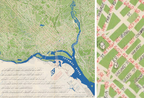
Image from DDOT.
Transit riders and cartography experts can’t fault the map designers too much. It was more challenging to illustrate detailed networks before the days of computers, and even in recent years some WMATA maps have been just as hard to follow.
Legibility aside, the map actually includes some very progressive elements considering its vintage. According to the legend, it only shows “all-day routes with frequent service, ” an incredibly useful idea that’s picked up a lot of steam in the past five years.
Other progressive elements shown on the map include bike paths, although the Mount Vernon and Rock Creek trails appear to be the only ones, and much of its text is translated into Spanish.
The map also includes a fun vignette of the Metrorail system, which had yet to open but was less than a year away.
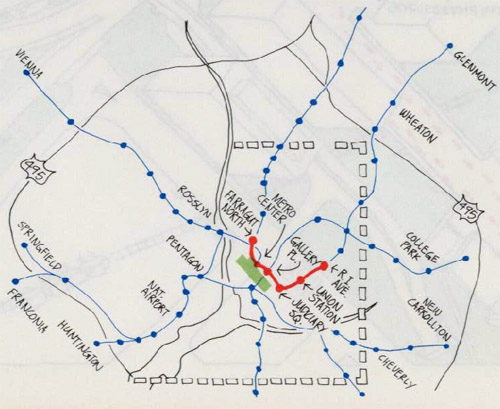
Image from DDOT.
On the other hand, some things never change. The legend for the Metrorail vignette notes Metro’s first phase was scheduled to open later in 1975. In actuality it didn’t open until 1976.
Finally, there are several other vignettes on the reverse side:
Image from DDOT.
Architecture firm John Wiebenson & Associates produced the map for the Bicentennial Commission of the District of Columbia.
Cross-posted at Greater Greater Washington.
Average Rating: 4.5 out of 5 based on 233 user reviews.
March 13th, 2015 | Permalink
Tags: bus, fun, history, maps, transportation


