|
Special Features


Image Libraries


|
|
Blog
This map shows the real-time location for every WMATA bus and train in the Washington region. It’s a cool way to see how much transit is out there, and where it’s running right this second.

Every WMATA bus and train. Image from TRAVIC.
The map is called TRAVIC and was produced by the University of Freiburg. The Washington map was made using using open data from WMATA.
Although the Washington map shows only WMATA transit, the same website includes maps for dozens of cities all over the world. You can compare what transit is like in diverse places, from Albuquerque to Paris.
 |
 |
| Left: Albuquerque. Right: Paris. Images from TRAVIC. |
I’ll be staring at this a long time.
 Comment on this at the version cross-posted to Greater Greater Washington. Comment on this at the version cross-posted to Greater Greater Washington.
Average Rating: 5 out of 5 based on 252 user reviews.
October 21st, 2015 | Permalink
Tags: bus, maps, metrorail, transportation

This is Main Street on Mackinac Island, in Lake Huron, Michigan. It’s a Michigan state highway, M-185, and it’s car-free year round.

Photo from Google.
M-185 encircles Mackinac Island, and forms the main street of the island’s town.
There’s no bridge to Mackinac Island. Visitors access it via airplane or ferry. With a lot of tourists but not many cars, M-185 has been car free since 1898.
I’ve never been there, but it looks pretty impressive in photos.
Have you been to Mackinac? Tell me what you think in comments at GGW.

The density of parked bikes looks like the Netherlands. Photo by Jasperdo on Flickr.

Photo by Jasperdo on Flickr.

Photo by Jasperdo on Flickr.

Bike for rent. Photo by ellenm1 on Flickr.
Comment on this at the version cross-posted to Greater Greater Washington.
Average Rating: 4.7 out of 5 based on 162 user reviews.
October 19th, 2015 | Permalink
Tags: bike, galleries, transportation
Mass-produced mobile homes are one of rural America’s most important forms of housing. One company wants to try the same concept with urban apartments. It’s a batty idea that may not work, but if it does, it could help to solve America’s urban affordability crisis.
The idea works like this: Rather than custom-designing every individual building, what if apartment buildings were mere frames, and apartments were mobile boxes that simply slipped into docks, the way cars park in a parking garage?
When people who live in mobile apartments move from one city to another, they could take their entire apartment with them. Slide out of your frame in Denver and slide into one in San Francisco, and keep on living without the disruption of emptying your home to a shell.
Perhaps most importantly, the company pushing this idea says they’d be drastically cheaper than a studio apartment.
The company, Kasita, is building a prototype in Austin next year, where they say they’ll rent units for around $600 a month. That’s half the cost of a downtown Austin studio.
Trade-offs abound
Obviously, there are trade-offs to this idea. At 200 square feet, these would be small apartments. Suitable for a single person, crowded for a couple, and hard to work with for a family.
Kasita’s version comes comes with high-tech bells and whistles like customizable wall panels, including speakers, shelves, a bike rack, even a fish tank and fireplace. But surely, if this concept takes off, competing companies would begin to offer more bare-bones versions.

Bells and whistles. Rendering from Kasita.
Kasita’s claim of $600 per month remains theoretical, and who knows how much it would actually cost to move one.
And aesthetically, a lot of people will think they’re ugly. Like shipping container apartments, mobile apartments will necessarily have an industrial look. A city full of these might quickly begin to feel oppressive.
The Japanese example
This is actually not a new idea. Japan has been home to some experiments in capsule architecture, most notably the 1972 Nakagin Capsule Tower. But Nakagin proved impractical and unpopular, and has slipped into disrepair. Fair from proving the concept works, it actually shows how failure is more likely than success.
These are real trade-offs, impossible to ignore. But given America’s growing affordability crisis, maybe they’re trade-offs that are worth experimenting with, sometimes, in some places, for some people.
Comment on this at the version cross-posted to Greater Greater Washington.
Average Rating: 4.8 out of 5 based on 165 user reviews.
October 16th, 2015 | Permalink
Tags: Uncategorized
Have you ever seen a traffic safety campaign that reprimands you for not wearing bright colors every time you cross the street? Of course you have. Here’s video proof that’s a load of bollocks.
In this viral video, a careless SUV driver rolls into a neon-clad police officer. There’s no ambiguity as to who’s at fault. The officer was stopped still, in broad daylight, and wearing the holy grail of bright clothes: a reflective vest. The SUV driver simply didn’t stop when he or she should have. Thankfully it all happens at slow speed, so it doesn’t appear the officer was hurt.
But this is a clear illustration of why it’s wrong to lecture pedestrians about wearing bright colors. It’s not reasonable to demand that everyone wear bright yellow every time they’re outside a car. But it is absolutely reasonable to demand that drivers not carelessly drive into people, no matter what anyone is wearing.
Comment on this at the version cross-posted to Greater Greater Washington.
Average Rating: 4.6 out of 5 based on 163 user reviews.
October 15th, 2015 | Permalink
Tags: bike, pedestrians, roads/cars, transportation
There will soon be a bona fide bike lane between downtown Fairfax and George Mason University, the first in Fairfax City.

Fairfax City’s first bike lane, location map and proposed design. Images from the City of Fairfax.
On September 29, the Fairfax City Council approved a one year pilot program to test a three block bike lane on University Drive, the street that connects downtown Fairfax to the largest university in Virginia.
The bike lane will begin just south of downtown Fairfax, and will run south as far as Armstrong Street. There, it will meet George Mason Boulevard, where Fairfax installed its first sharrows a few years ago.
Crews will restripe University Drive this autumn, to change its configuration from having two car lanes in each direction, to having one car lane each way, a central turn lane, and bike lanes next to each curb.
A baby step
This bike lane, and its associated road diet, is a nice baby step for a community that’s never given bikes much thought.
But a baby step it is. Not only did officials promise to reevaluate and possibly remove the bike lane after one year, but they significantly shortened it from the original proposal.
At one point, planners had hoped to stripe the bike lane north through downtown Fairfax, as far as Layton Hall Drive. Unfortunately, that was a no-go.

Map of the approved bike lane, canceled portion, and existing sharrows. Map by the author, using base map from Google.
A natural location
Fairfax City isn’t a big community. It’s located roughly between I-66 and George Mason University, and its historic downtown is one of the more walkable places in Northern Virginia outside the Beltway.
With a walkable downtown and a big university, it’s a natural for better bike infrastructure.
Unfortunately, decades of suburban road design have left most of Fairfax City just as car-dependent as surrounding Fairfax County. Now, that’s beginning to change. But ever so slowly.
Comment on this at the version cross-posted to Greater Greater Washington.
Average Rating: 4.7 out of 5 based on 203 user reviews.
October 13th, 2015 | Permalink
Tags: bike, transportation
A miniature Target is now open in Rosslyn, occupying the ground floor of an office tower. At less than a sixth the size of a typical suburban Target, it shows how retailers are adapting to America’s increasingly urban reality.

Inside Rosslyn’s Target.
The store had a soft opening last week, and an official opening Sunday. At 23, 000 square feet, it’s about the size of a large Trader Joe’s, or a small Safeway. It’s minuscule compared to normal Target stores, which often top 150, 000 square feet.
And yet, it’s got a little of everything, just like a normal Target.

Inside Rosslyn’s Target.
A few years ago, when I lived in a Ballston high rise, I’d have killed to have a Target on the Orange Line. The only department stores I had easy access to were the Macy’s in Ballston and downtown DC. And, for a recent college grad spending way too much on housing, Macy’s wasn’t in my budget for housewares.
Now urban department stores are sprouting everywhere.

Rosslyn’s Target, from Wilson Boulevard.
This is, by my count, at least the Washington region’s fourth fifth urban-format Target. The first opened in the 1990s in Gaithersburg. Then came Columbia Heights in 2008 and Merrifield in 2012, then our first mini Target earlier this year in College Park.
Walmart joined the game beginning in late 2013, with urban stores downtown and on Georgia Avenue.
Smaller stores may be the new normal
It’s not just Target and Walmart looking to get in on this game. Other chains are launching a new breed of mid-size stores, like this mini Target, in a race to fill the urban retail niche.
In 2013, Walgreens opened a new “flagship” store in Chinatown. At 23, 000 square feet, it’s almost exactly the same size as the new Rosslyn Target, and twice a normal Walgreens.

The flagship Walgreens. Photo from Google.
And although their merchandise selections are a little different (the Target has more clothes and housewares, while the Walgreens has more beauty & health products), the Rosslyn Target and the Chinatown Walgreens are clearly evolving towards becoming a similar category of store: The not-quite-department-store, or the 21st Century general store.
Whatever you call it, it’s a growing retail niche.
Comment on this at the version cross-posted to Greater Greater Washington.
Average Rating: 5 out of 5 based on 186 user reviews.
October 12th, 2015 | Permalink
Tags: development, economy, The New America
Metrorail’s six lines are so easy to remember that most Washingtonians have memorized them. Here are five convenient bus lines that everyone in town should know just as well.
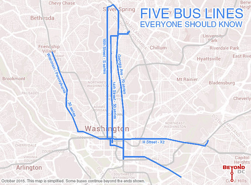
Simple map of 5 main DC bus lines. Original base map from Google.
These five lines are among Metro’s most convenient and popular. Buses on them come every few minutes, and follow easy-to-remember routes along major streets.
For the sort of Washingtonian who’s comfortable with Metrorail but hasn’t taken the leap to the bus, these five lines are a great place to start. Unlike some minor buses that only come once every half hour, you can treat these five lines the way you’d treat a rail line, or a DC Circulator: They’re always there, and it’s never a long wait before the next bus.
If you can memorize Metrorail’s Red and Orange Lines, you can memorize these streets:
Wisconsin / Pennsylvania (30 series): If you want a bus on Wisconsin or Pennsylvania, just remember to catch anything with a number in the 30s. Nine bus routes cover this line, each of them with slightly different details, but a similar overall path: The 30N, 30S, 31, 33, 32, 34, 36, and the express 37 and 39. Collectively they’re called the “30 series.”
The other four lines are similar. Each has multiple routes with slightly different details combining to form a family, or series. Within each series some individual routes may come at different times of day, or continue farther beyond the lines this map shows. But the key is to remember the series name.
16th Street (S series): Four routes, each beginning with the letter S: The S1, S2, S4, and the express S9.
14th Street (50 series): Three routes, each in the 50s: The 52, 53, and 54.
Georgia Avenue (70 series): Two routes, in the 70s: The local 70 and the express 79.
H Street (X series): Two routes, starting with X: The local X2 and the express X9. When it eventually opens (knock on wood), the DC Streetcar will beef up this same corridor.
For the Metrobus veterans among you, this is old news. About 80, 000 people per day ride these five lines, so they’re hardly secrets. But if you’re not a frequent bus rider, give these a try.
Comment on this at the version cross-posted to Greater Greater Washington.
Average Rating: 4.8 out of 5 based on 292 user reviews.
October 6th, 2015 | Permalink
Tags: bus, transportation
|
Media


Site
About BeyondDC
Archive 2003-06
Contact
Category Tags:
Partners
|


