|
Special Features


Image Libraries


|
|
Blog
Usually when it comes to dedicated street lanes for transit and bicycles, the more physical separation from car lanes there is, the better off you are. Better physical separation is why cycle tracks are better than regular bike lanes, and why busways are better than striped bus lanes.
Unfortunately, physical separation adds complexity and cost, so it’s not used as often as it might be.
That in mind, take a look at this picture from Guadalajara, Mexico, where a very affordable measure of physical separation has been added to a bus lane:

Photo by SoCalMetro on flickr.
This solution wouldn’t work in a lot of places for a lot of reasons, and even where it would work it isn’t as good as the expensive heavily-engineered options. But nevertheless it’s a cheap way to squeeze some separation into some bus lanes. It’s worth considering, wherever there isn’t a need for cars to cross over the bus lane, and where a more expensive solution isn’t practical.
The first cycle tracks in the US were heavily engineered and expensive, but we quickly learned that they needn’t be. Maybe it’s time to ask whether that same lesson can apply to busways.
Average Rating: 4.9 out of 5 based on 259 user reviews.
October 4th, 2012 | Permalink
Tags: BRT, bus, transportation, urbandesign

Planners often promote Bus Rapid Transit (BRT) as cheap to build and more flexible than rail transit. But that flexibility also makes it even cheaper to dismantle. A stroke of the pen can completely destroy a BRT line.
Even the highest quality BRT systems run in lanes that could just as easily serve regular drivers. All it takes is one government decision to allow private cars on a BRT busway, and then blam: what you have isn’t really BRT anymore.
That’s exactly what may happen in Delhi, India, where the country’s supreme court is considering forcing the city to open up bus lanes for automobile traffic, amid complaints from drivers that it’s “unfair” to dedicate lanes to other road users. Delhi has 16 million residents, and fewer than 20% of them use cars. Nevertheless, it’s a serious possibility that the court will open the busways, effectively outlawing BRT.
Here in Washington, we have our own local example of a BRT line that has been systematically downgraded by being opened to cars, reducing the quality of bus service.
The Shirley Highway Busway was the first exclusive bus facility on a US urban highway when it opened in 1969. It was so successful that in the early 1970s, over 50% of all the passenger traffic on the Shirley Highway, the portion of I-95/I-395 from Woodbridge to the Potomac, traveled via bus.
Despite this success, Virginia opened up the busway to car traffic after a few years, beginning with HOV-4 users in December 1974. Since then, the restrictions on cars have been periodically reduced, and soon even single-occupant vehicles will be able to use the road, thanks to Virginia’s HOT lanes project.
Wherever you build lanes that cars could use, car drivers will want to use them, and will exert political pressure to do so. Every BRT project that exists or is planned anywhere could be converted to a road for cars, without spending an additional dollar on construction.
This is not to say that BRT is useless. It certainly is not. BRT belongs in all our big cities, as one piece of a larger multimodal transit network. But the same flexibility and low cost that makes BRT attractive in many locations is simultaneously the reason it cannot be trusted to deliver on long-term promises in the same way as rail. It is easy to eliminate, and it has too great a history of being eliminated.
Average Rating: 4.8 out of 5 based on 201 user reviews.
July 11th, 2012 | Permalink
Tags: BRT, roads/cars, transportation
|
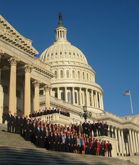
Image by Talk Radio News Service. |
Congress passed a major transportation bill last week, authorizing more than $100 billion in spending for highways, transit, and other modes over the next 2 years. The bill changes a number of rules and shifts the ways in which money is distributed, in an effort to preserve highway funding.
The bill generally maintains the status quo of federal transportation spending, but attempts to stretch the amount of money available for highways by eliminating or consolidating fringe programs, and shifting money from grants to loans.
$54.6 billion will be available per year, for the next 2 years. About 80% of funding will go to highways, and about 20% will go to transit. Both the overall funding level and the 80/20 split are comparable to existing allocations.
The gas tax will remain at 18.3¢ per gallon, as it has since 1993 when gas was $1.07. Since this won’t produce enough revenue to maintain current spending, almost $20 billion in federal general fund money will be infused in to the transportation fund.
Highways
As in every previous federal transportation authorization, the bulk of spending authority goes to highways. Most of the money will be automatically distributed to state Departments of Transportation, which will have the authority to determine spending on roads within their borders.
Little about this system will change, except that a little bit more money is available for highways due to cuts to other modes.
One thing that may change relating to highways is the make-up of the fleet of cars and trucks using them. This bill eliminates the so-called “gas guzzler tax, ” which raised a small amount of money but was a disincentive towards buying the least efficient cars and SUVs.
Another change is that more funding, up to $1 billion per year, is being directed to the TIFIA program, which offers loans to states and localities for major capital projects, instead of direct grants. TIFIA loan details are more favorable than private market deals, so this is a good option for large projects that don’t get grants. Meanwhile, by expanding a program that requires participants to pay it back, the feds stretch limited dollars further.
Transit
At one stage of negotiations, Republicans in Congress sought to eliminate transit funding altogether. That would have been a disaster. Thankfully it didn’t happen.
Much of the transit money flows to transit providers through automatic formulas, similarly to how highway money flows to state DOTs. The largest pot of non-automatic money is in the New Starts program, which is the major federal source for money to build new rapid transit routes.
New Starts is funded at $1.9 billion per year, which is $50 million per year less than the existing allocation.
For that money, the list of project types that are eligible to receive New Starts grants has been broadened, to include more BRT projects, as well as projects that expand the core capacity of existing transit lines. Also, a special category has been established for “demonstration projects” that are primarily funded with local or private money, and only need a little federal funding.
New Starts is extremely important. Virginia received $900 million from it to help build the Silver Line, and Maryland is counting on it to help fund the Purple Line, Corridor Cities Transitway, and Baltimore Red Line. Expanding the list of eligible uses is good, but it further spreads out an already diminished pot of money.
The competition for New Starts grants will be fierce, and the supply definitely won’t meet the demand.
Another change from previous law is that tax-exempt benefits for transit riders will continue to be capped at $125/month, while car drivers will continue to be eligible for corresponding parking benefits of up to $240/month. This is a blatant subsidy for driving over transit use, and is extremely unfortunate.
Some positive news is that there are two new transit programs established in the bill.
The first is a safety program that will institute nationwide safety standards for railcars, and require large transit agencies to establish safety plans. This is a direct outgrowth of WMATA’s problems in recent years, especially the June 2009 Metrorail crash.
The second new program will offer planning grants to help communities plan and build Transit Oriented Developments around transit stations, which is a nice win for smart growth.
Bike/ped
Bicycle and pedestrian funding was a major target for attack, and a major point of contention. Many rural and conservative congresspeople don’t understand the importance of these modes to urban transportation, and view them as unnecessary luxuries.
At several points throughout the negotiation process, it looked like dedicated bike/ped funding might be eliminated entirely. With the final adopted bill, it was reduced from about $1 billion annually to about $700 million annually. That’s too bad, but the fact that any survived at all is good news.
Of that $700 million, half will be distributed via automatic formula to Metropolitan Planning Organizations (MPOs) for use on bike/ped projects. Previously all of this money had been distributed to states, so sending it to metropolitan areas is an interesting change, and could be seen as an experiment in funneling money directly to metropolitan areas instead of through states.
Unfortunately, the other half of the $700 million in bike/ped money will go to state DOTs, who will have the option of either using it for bike/ped projects, or of flipping it in to their highway funds and using it for road projects. If all the states do this, it will decrease the total amount of federal bike/ped funding to just $350 million.
Although it is not strictly a dedicated bike/ped fund, another pot of money that is often used for bike/ped projects is the Congestion Mitigation and Air Quality program (CMAQ). Capital Bikeshare has largely been funded via CMAQ, so it is a significant program.
The good news is that CMAQ funding levels appear to be level. The bad news is that the list of eligible project types that can use CMAQ funds has been broadened to include a larger variety of road projects.
Environmental issues
Republicans in Congress had wanted to include in the bill funding for the Keystone Pipeline, which would have transported crude oil from Canada to refineries in the US. Democrats opposed it, and the fight was one of the most widely-reported sticking points in the negotiations.
Funding for the pipeline was not included, which was the major Republican concession agreed upon, in response to Democrat concessions regarding bike/ped and transit funding.
However, another aspect of the bill may have even more important and widespread effects.
A rarely-reported provision aimed at streamlining project delivery will eliminate the requirement for federal environmental review for a wide range of projects, including those within existing right-of-way, those that are below certain cost thresholds, and those that replace damaged infrastructure.
Excluding those projects will undoubtedly save millions of dollars, and months or even years of project planning. But it will also eliminate a key step in project review, and reduce the ability of localities to object to undesirable projects imposed on them by states. It is definitely a mixed blessing situation.
Summary
Just about everyone in the transportation policy world agrees that the current federal funding system isn’t working. Costs keep rising, and with the gas tax flat, spending power keeps dropping. Unfortunately, not everyone agrees about what to do.
Some want to find more sustainable revenue sources, and use them to build multimodal 21st Century infrastructure. Others want to eliminate multimodal programs and focus on spending limited money on what they see as the most important priority, highways.
This bill is a compromise. It puts off the larger questions of our country’s long term needs, and takes a slight regressive lean, in order to continue for 2 more years the overall status quo of an 18.3¢ tax going to an 80/20 highway/transit split.
 Cross-posted at Greater Greater Washington. Cross-posted at Greater Greater Washington.
Average Rating: 4.5 out of 5 based on 189 user reviews.
July 3rd, 2012 | Permalink
Tags: bike, BRT, bus, government, lightrail, metrorail, roads/cars, transportation
|
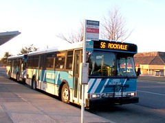
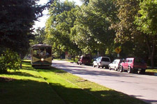
A Ride-On bus in Gaithersburg.
Not BRT. |
A report is making the rounds today that claims the Corridor Cities Transitway BRT line could be built for far less money if buses were routed in mixed traffic rather than on a transitway, if “temporary stops” were built instead of stations, and if park and rides were eliminated from the outer stations.
The report is wrong in one very fundamental way: It is impossible to build a bus rapid transit Corridor Cities Transitway for the amount of money they claim.
What *is* possible is to build something so entirely different from the Corridor Cities Transitway that you couldn’t call it the same thing.
It is totally possible to build a non-rapid, non-transitway bus route for a lot less money. And, in doing so, provide a vastly inferior product that would be vastly less convenient, and which would serve vastly fewer passengers.
The report’s authors claim that their redesign wouldn’t slow buses all that much, but they completely miss the point that ride quality also matters. Eliminating stations in favor of normal bus stops and taking away park and rides might not technically slow buses down, but it would certainly affect ridership.
If highway engineers eliminated the exits from an Interstate highway and replaced them with stop lights, the resulting road wouldn’t be an Interstate highway. That’s essentially what is being proposed here. The changes look small on paper, but they add up to big reductions in quality.
If highway engineers eliminated the exits from an Interstate highway and replaced them with stop lights, the resulting road wouldn’t be an Interstate highway.
|
|
Montgomery County currently operates about 100 Ride-On bus routes. They could easily add a new Route 101, have it run on existing streets along the Corridor Cities Transitway alignment, and call it a day. Doing that would save a lot of money, but it wouldn’t be providing bus rapid transit.
It’s a bit of a straw man to claim the authors of this report want to go that far, but only a bit. Their proposal would strip the CCT of so many of the amenities that separate it from a normal bus route that functionally, it may as well be one. We’d be left with something that looks a lot like MetroExtra; a little better than local buses, but not BRT.
The real kick to the knees here is that anyone who has followed transit development over the last decade could have predicted this. Stripping BRT projects of their amenities is called BRT creep (and here at GGW), and it happens so often that it’s probably inherent to BRT projects.
The good news is that the Montgomery County Council appears to recognize what a terrible idea this is. Councilwoman Nancy Floreen says “I don’t think we want to do the CCT on the cheap … We want to make this as close to a light rail experience as we can.” Councilman Phil Andrews says the proposal “subjects riders to the same traffic that we want to get them out of.”
But sticking to those guns is going to take a lot of political will, over a long and sustained time. It’s going to take years for the CCT to be built, and this is already the second time the news media has picked up on opponents’ proposal to redefine it as a non-BRT line. Presumably they will continue, and the threat of BRT creep will be with the CCT until the day it opens (and maybe after).
Average Rating: 4.5 out of 5 based on 157 user reviews.
June 21st, 2012 | Permalink
Tags: BRT, bus, transportation
|
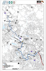
CCT’s adopted route map, showing two phases. |
Maryland has officially finalized its planning for the Corridor Cities Transitway (CCT). In so doing the state has finally answered a number of lingering questions about the Gaithersburg-to-Clarksburg route.
- The line will be BRT rather than light rail. With light rail being advanced for the Purple Line and Baltimore Red Line, the more suburban Corridor Cities Transitway would have been one rail line too many for the state to afford. Everyone would rather have light rail, but as I said in 2008 and again in 2009, doing BRT for the CCT is the right decision given the constraints.
- It will be built in two phases, with the first phase ending at Metropolitan Grove in northwest Gaitherburg, where there’s a MARC transfer available.
- The route will follow its long-planned alignment along King Farm Boulevard, despite objections from some neighbors.
- The Crown Farm station will be located to maximize the planned TOD at that location.
- There will be four stations in the Life Sciences Center office park, which will serve a lot of workers and help to redevelop that area, but which will also slow down buses considerably.
- The Kentlands station is sensibly placed on the west side of Great Seneca Highway, where it will be ideal for future infill.
- The final station is at Comsat office park in Clarksburg, which means the route unfortunately misses two potentially major nearby centers, Clarksburg Town Center and the Milestone shopping center.
Overall, the adopted plan addresses many of the problems I identified in 2006. It’s not perfect, but it’s workable, and it will have a hugely positive effect on how Gaithersburg operates.
Maryland can now move the project into the federal government’s New Starts process, where it will compete with other projects around the country for funding. Ideally they will move into more specific engineering in another year or so, with construction beginning in 2018 and service beginning on the first phase in 2020.
Average Rating: 4.9 out of 5 based on 156 user reviews.
May 14th, 2012 | Permalink
Tags: BRT, transportation
|
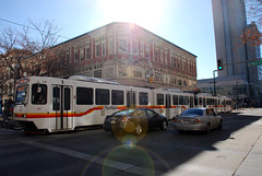
Is this light rail or streetcar? |
What’s the difference between a streetcar and light rail? What qualifies as BRT versus merely priority bus? One problem with contemporary transit planning is that there’s really no solidly defined answer for those questions.
Originally the term light rail was invented to describe streetcar systems that had express service characteristics. So light rail was really just rapid streetcar. But even the most express light rail systems often run slowly along on surface streets at the downtown end of their route, which muddies the waters.
Furthermore, transit agencies around the country name their lines whatever they want. For decades Philadelphia called one of its light rail lines a high speed trolley. Meanwhile, Tacoma, WA runs a short streetcar line that uses the exact same rail vehicles as Portland’s famous streetcar, but Tacoma calls it light rail.
The situation is even more muddy for buses, since terms like BRT and priority bus are relatively new. Indeed, communities buying off on the concept of BRT only to see it scaled back has become such a continuous problem that Congress is now considered adopting standards that bus lines must meet in order to be called BRT.
So this is a fairly big problem.
I do think there’s a fairly easy, practical, and common sense answer available, however. Does your line run in a dedicated transitway or not? If so, it’s rapid. If not, it’s local. Here’s a handy table describing this system, which is how I’ve personally been mentally sorting transit systems for years:

This does leave two problems unresolved.
First, how do you sort a striped transit lane? The bus lane on 7th Street in Gallery Place is obviously vastly inferior to a true busway, but surely it counts for something.
Second, what to do with transit lines that have different characteristics along different portions of their length? One of the main selling points of both LRT and BRT is that they’re very flexible, and can built to fit the needs of the community. Thus it’s pretty rare to find a line that operates in the same sort of running way for its entire length. Many use a dedicated transitway for part of their length, then mix with traffic elsewhere.
But at the very least, the above table can be useful as a way to generally describe many transit systems. So I think it’s useful.
Average Rating: 4.6 out of 5 based on 282 user reviews.
February 28th, 2012 | Permalink
Tags: BRT, bus, lightrail, proposal, streetcar, transportation
It wasn’t too many years ago that transit was an afterthought in the United States. For years at a time in the latter half of the 20th Century only a handful of US cities were actively building new transit lines at any given time.
But as this map from national transit blog The Transport Politic shows, the times, they’re a-changin’.
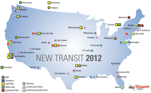
Major transit openings and construction starts planned for 2012.
Image by Yonah Freemark on The Transport Politic.
The map was published as part of an extensive post that lists every major transit line in the US that will either open or be under construction in 2012.
The list is impressive. Nearly every major metropolitan area in the country is represented, and even more would be if the list included projects in the planning stages but not yet slated to begin construction.
The listed projects range from the gargantuan to the mundane. From New York’s Second Avenue subway, to a BRT line in Fort Collins, Colorado.
The three map icons next to Washington indicate DC’s streetcar projects and the two phases of the Silver Line. Other local projects, such as the Purple Line, the Columbia Pike streetcar, and the Corridor Cities Transitway, aren’t shown because they are still in planning.
Our country still has a long way to go before the decades of automobile-focused planning are fully repaired. Even this list, impressive as it may be, is short compared to the highway construction list from most individual states. But still, we’re making progress as a country. We’re doing things now that we weren’t doing a few decades ago. Transit is reaching more people, in more places.
So let’s congratulate ourselves for a solid step forward. But let’s not be too happy; there’s still much work to be done.
Cross-posted at Greater Greater Washington.
Average Rating: 4.4 out of 5 based on 226 user reviews.
January 4th, 2012 | Permalink
Tags: BRT, commuterrail, lightrail, metrorail, streetcar, The New America, transportation
|
Proposed Baltimore Red Line subway station. |
With yesterday’s news that the Baltimore Red Line is being advanced to Preliminary Engineering, it seems a good time to check up on the various rail and BRT projects in the region and report on their status. I’ve ranked them below by planning category and anticipated completion, and have included Nofolk’s light rail line even though it’s outside the region.
For the purposes of this post, projects will be categorized into the following phases:
- Concept: The project is in early planning, including alternatives analysis and environmental clearance.
- Design: The project is in the engineering phase, including Preliminary Engineering (PE). Conceptual details have been finalized and detailed construction plans are being prepared.
- Construction: The project is under construction.
| Project |
Status |
Description |
Anticipated Opening |
| Norfolk ‘The Tide’ Light Rail |
Construction |
Construction is largely complete. Trains and tracks are in testing now. |
August 19, 2011 |
| H Street Streetcar |
Construction |
Streetcar running from Union Station to the Anacostia River via H Street. Under construction now. |
2012 |
| Silver Line Phase I |
Construction |
Metrorail extension from East Falls Church to Reston via Tysons Corner. Under construction now. |
2013 |
| Crystal City Potomac Yard Busway |
Design |
Exclusive busway from Crystal City Metro to Braddock Road Metro. Final design underway now. Some segments have already been constructed by private developers. |
2013 |
| Baltimore Red Line |
Design |
Light rail line running east-west through Baltimore. Recently advanced to PE from Concept. |
2016 |
| Silver Line Phase II |
Design |
Metrorail extension from Reston to Loudoun County via Dulles Airport. PE currently underway. |
2017 |
| K Street Transitway |
Design |
Exclusive transit lanes running east-west on K Street from Washington Circle to Mount Vernon Square. Environmental work completed in 2009, now awaiting funding before moving forward. |
Not published |
| Anacostia Streetcar |
Construction/Concept |
Streetcar from South Capitol Street to 11th Street bridge via Ancostia Metro. Construction of a short segment near South Capitol Street is mostly complete. The majority of the line is undergoing an alternatives analysis / environmental review that will be completed late in 2011. |
Not published |
| Benning Road Streetcar |
Concept |
Extension of the H Street Streetcar east across Anacostia River to Benning Road Metro. Alternatives analysis & environmental review to begin summer 2011. |
2015 |
| Columbia Pike Streetcar |
Concept |
Streetcar from Pentagon City to Bailey’s Crossroads via Columbia Pike. Environmental planning underway now. |
2016 |
| Potomac Yard Metro Station |
Concept |
Infill Metro station in Alexandria. Environmental planning underway now. |
2016 |
| K Street Streetcar |
Concept |
Extension of the H Street Streetcar west to Washington Circle through downtown Washington, potentially via the K Street Transitway. Alternatives analysis & environmental review to begin summer 2011. |
2018 |
| Crystal City Potomac Yard Streetcar |
Concept |
Potential conversion of CCPY busway to streetcar. Environmental planning underway. |
Not published |
| Maryland Purple Line |
Concept |
Light rail line running east-west through Maryland suburbs of DC. Concept stage largely complete. Expected to move to PE in summer or autumn 2011. |
2020 |
| Corridor Cities Transitway |
Concept |
Light rail or BRT line running north from Shady Grove Metro. Concept stage nearing completion. Mode will be determined this year. Expected to move to PE in late 2011 or 2012. |
2020 |
| DC Streetcar Other Segments |
Pre-Concept |
The rest of DC’s proposed 37 mile streetcar system. Planning has not yet begun. |
Not published |
Average Rating: 4.9 out of 5 based on 163 user reviews.
June 28th, 2011 | Permalink
Tags: BRT, featured post, lightrail, metrorail, streetcar, transportation
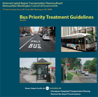
Want to build a busway? The Transportation Planning Board can teach you how. This Spring the TPB released an impressive set of Bus Priority Treatment Guidelines intended to illustrate how to implement priority bus treatments such as dedicated running ways, signal priority, and enhanced stations.
The idea is partially to provide regional transportation planners and engineers with the technical details necessary to actually build such improvements, but also to provide politicians and laypeople with a visual tool box of potential bus improvements, so they know what to ask for.
If you’re interested in how streets might be improved to provide better bus service, these guidelines are a must read.
Average Rating: 5 out of 5 based on 222 user reviews.
June 24th, 2011 | Permalink
Tags: BRT, transportation
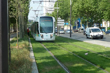
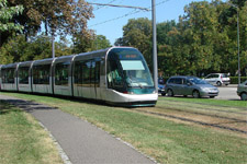
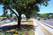
Transitways don’t have to be ugly. They don’t even have to be paved. There are many examples around the world of grass-track transitways for light rail or BRT, and a lot of local interest in using them here. Maryland is actively considering grass tracks for the Purple Line, and the idea could theoretically be applied to the Corridor Cities and Crystal City transitways as well.
Since apparently some of the opposition to transit in King Farm is based on the absolutely incorrect misconception that all transitways must consist of massive concrete barriers, here are examples of grass transitways from around the world.

New Orleans, LA – By tinydr |
Fort Collins, CO – By BeyondDC |

Kenosha, WI – By kschmidt626 |

Concept for Purple Line – By State of Maryland |
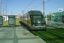
Porto, Portugal – By gradiate |
Paris, France – By collilnchurcher2003 |
Strasbourg, France – By GEO.Hellas |
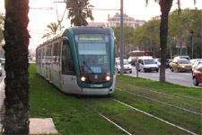
Barcelona, Spain – By Daniel Sparing |
Even BRT can be accommodated in a grass transitway, as Eugene, Oregon’s Emerald Express illustrates:
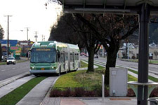
Eugene, OR BRT – By City of Alexandria, VA |
Eugene, OR BRT – By rob_wrenn |
Cross-posted at Greater Greater Washington.
Average Rating: 4.8 out of 5 based on 203 user reviews.
May 23rd, 2011 | Permalink
Tags: BRT, galleries, lightrail, transportation, urbandesign
|
Media


Site
About BeyondDC
Archive 2003-06
Contact
Category Tags:
Partners
|


