|
Special Features


Image Libraries


|
|
Blog
|
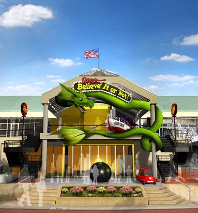
Proposed Ripley’s Believe It or Not at Baltimore Harborplace. |
When Baltimore’s Inner Harbor was redeveloped in the late 1970s and early 80s it was called an “urban miracle.” At the time, inner cities around the country were declining everywhere, and nobody expected a run down place like Baltimore to succeed. But it did, with a winning combination of cultural activities, shopping, and dining that made the Inner Harbor one of Maryland’s greatest tourist destinations.
Since 1980 the centerpiece of the Inner Harbor has been the Harborplace Mall, a pair of two-story shopping pavilions that frame the waterfront.
But the problem with malls is that after about 30 years they start to get pretty dated. At 32, Harborplace is surviving thanks to its central location, but it’s no longer pulling in the most desirable tenants. High-paying stores that once might have located in Harborplace are now going elsewhere, such as Lockwood Place and the Power Plant.
As a result, Harborplace is turning to less conventional tenants. If the mall can’t be a shopping mecca, maybe it can be a kitschy entertainment hub. Thus the proposal to make a Ripley’s Believe it or Not museum the mall’s newest anchor.
The proposal makes sense in the short term. Ripley’s kitschy museum in Ocean City is a landmark, and has been reasonably popular. It’s something that will continue to appeal to tourists in a way that a discount retailer would not.
But in the longer term, Ripley’s won’t save Harborplace from its real problems. Tourism and malls are both fickle businesses, and Harborplace offers little that newer competitors can’t do better. Eventually Ripley’s will move on as well. What then?
Odds are Harborplace has a couple of decades left, but eventually it’s going to make sense to start thinking about a replacement. And when that day comes, the answer probably won’t be to just build a newer mall.
Average Rating: 4.6 out of 5 based on 198 user reviews.
February 29th, 2012 | Permalink
Tags: development

|
Is this light rail or streetcar? |
What’s the difference between a streetcar and light rail? What qualifies as BRT versus merely priority bus? One problem with contemporary transit planning is that there’s really no solidly defined answer for those questions.
Originally the term light rail was invented to describe streetcar systems that had express service characteristics. So light rail was really just rapid streetcar. But even the most express light rail systems often run slowly along on surface streets at the downtown end of their route, which muddies the waters.
Furthermore, transit agencies around the country name their lines whatever they want. For decades Philadelphia called one of its light rail lines a high speed trolley. Meanwhile, Tacoma, WA runs a short streetcar line that uses the exact same rail vehicles as Portland’s famous streetcar, but Tacoma calls it light rail.
The situation is even more muddy for buses, since terms like BRT and priority bus are relatively new. Indeed, communities buying off on the concept of BRT only to see it scaled back has become such a continuous problem that Congress is now considered adopting standards that bus lines must meet in order to be called BRT.
So this is a fairly big problem.
I do think there’s a fairly easy, practical, and common sense answer available, however. Does your line run in a dedicated transitway or not? If so, it’s rapid. If not, it’s local. Here’s a handy table describing this system, which is how I’ve personally been mentally sorting transit systems for years:

This does leave two problems unresolved.
First, how do you sort a striped transit lane? The bus lane on 7th Street in Gallery Place is obviously vastly inferior to a true busway, but surely it counts for something.
Second, what to do with transit lines that have different characteristics along different portions of their length? One of the main selling points of both LRT and BRT is that they’re very flexible, and can built to fit the needs of the community. Thus it’s pretty rare to find a line that operates in the same sort of running way for its entire length. Many use a dedicated transitway for part of their length, then mix with traffic elsewhere.
But at the very least, the above table can be useful as a way to generally describe many transit systems. So I think it’s useful.
Average Rating: 4.8 out of 5 based on 180 user reviews.
February 28th, 2012 | Permalink
Tags: BRT, bus, lightrail, proposal, streetcar, transportation
This is a NASA picture of the US mid-Atlantic, taken from the International Space Station a couple of weeks ago.
I tweeted it over the weekend, but readership is much higher over the week and this is just too cool to miss.

Click to enlarge, as usual.
Average Rating: 4.7 out of 5 based on 268 user reviews.
February 27th, 2012 | Permalink
Tags: fun, galleries
|
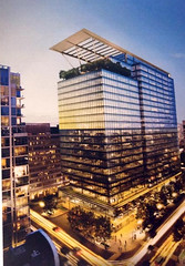
Proposed 24-story building in Crystal City. |
Crystal City is like a miniature downtown Washington, in the sense that most of the buildings are mid-rises of the same height. But it won’t be for much longer.
Crystal City’s height limit is the result of proximity to Reagan National Airport, and was imposed by the Federal Aviation Administration, not Arlington County. For decades the FAA was very strict about its height limit; exceptions were not allowed. However, in recent years they have reevaluated those rules, and are now willing to negotiate building heights on a case-by-case basis.
The first major exception to the height limit came in 2009, when 6 floors were added to 220 20th Street as part of an office-to-residential building renovation.
About that same time, Arlington adopted its new Crystal City Sector Plan, which calls for significantly taller buildings throughout the neighborhood.
And now, the first major new development has been proposed under that plan. Pictured at right, the proposal is for a soaring 24-story office tower at 1900 Crystal Drive. It will be Crystal City’s tallest building, at least until something even taller comes along.
In order to build the new tower developers will have tear down the existing 11-story office building at 1851 S. Bell Street. They’ll also need endorsements from Arlington County and the FAA, obviously.
ARLnow has more details.
Average Rating: 4.5 out of 5 based on 194 user reviews.
February 24th, 2012 | Permalink
Tags: development, urbandesign
As urban bicycling becomes more common, new types of infrastructure are being invented to help bikes safely mix with cars. The latest innovation is what’s called a “two-stage bike box.” Arlington is proposing one for this particularly confusing intersection:
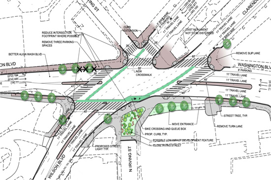
This intersection, of Wilson, Washington, and Clarendon Boulevards, is often referred to as “Clarendon Circle, ” because it used to be one. During the 20th Century the circle was removed and the intersection widened. Now Arlington wants to make it safer for pedestrians and bicyclists.
There are a lot of interesting things going on with this plan, but the most interesting is the bike queuing zone in the lower right corner of the intersection. The idea is that cyclists hoping to cross Washington Boulevard in order to move east along Clarendon Boulevard will have a dedicated and safe place to wait, separated from both cars and pedestrians.
The two-stage bike box is similar to regular bike boxes, except that it’s located in a reserved corner of the intersection rather than between the crosswalk and stopping stripe.
A normal bike box placed behind the crosswalk on either southbound Washington Boulevard or eastbound Wilson Boulevard would be less versatile, because it would only benefit cyclists on that one street. The two-stage box benefits people moving onto Clarendon Boulevard from both Wilson and Washington, which is why it’s a clever innovation at this location.
There are a few two-stage bike boxes in Portland and New York, but they use a somewhat different design. Clarendon Circle will be the first implementation of this idea in the DC area, and will also be the first-anywhere use of this particular design, which hugs the curb in an inverted nub.
 Cross-posted at Greater Greater Washington. Cross-posted at Greater Greater Washington.
Average Rating: 4.4 out of 5 based on 232 user reviews.
February 23rd, 2012 | Permalink
Tags: bike, transportation, urbandesign
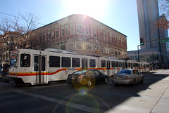
From flickr user Andrew C Mace:

Average Rating: 4.4 out of 5 based on 182 user reviews.
February 22nd, 2012 | Permalink
Tags: fun, galleries
Fairfax County has proposed truly awful names for its Metro stations on the soon-to-open Silver Line. They are indistinct, confusing, and would completely fail to establish any sort of identity for the neighborhoods they serve.
Luckily, the ultimate decision for what to name Metro stations falls to the WMATA Board, and they are interested in using some potentially superior names. They’ve created a public survey requesting feedback on the proposed names, including several alternate suggestions for each station.
In 2008 I suggested the following names for the four stations in Tysons Corner, some of which are being considered in Metro’s survey: Scott Run, Galleria Center, Westpark, Spring Hill.
Please, for the love of all that is good in the world, take the survey and tell Metro to use names that will help create a sense of place. At the very least, tell them to use names that aren’t so indistinguishable.
Take the survey now
Average Rating: 4.7 out of 5 based on 299 user reviews.
February 21st, 2012 | Permalink
Tags: metrorail, proposal, transportation
|
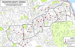
Bikesharing expansion plan for Rosslyn-Ballston. |
One by one, Capital Bikeshare is coming to Metro station neighborhoods along Arlington’s Rosslyn-Ballston corridor (Orangeington?). Bikesharing reached Rosslyn last April, was extended to Courthouse and Clarendon in November, and as of today reaches Virginia Square. Ballston is the last station in the corridor remaining without Cabi, but it won’t be for long.
The new station at Virginia Square Metro was installed early this morning and is already up and running. A second station will be installed today at Arlington’s Central Library, but as of this writing it hasn’t opened yet (Update: it’s in). A third station will go in next week in Clarendon at Washington Blvd and 10th Street.
The major roll-out of several new stations throughout Rosslyn-Ballston is expected in March or April, once the equipment arrives from the vendor.
Average Rating: 4.8 out of 5 based on 246 user reviews.
February 17th, 2012 | Permalink
Tags: bike, transportation
Actually it’s a trike.
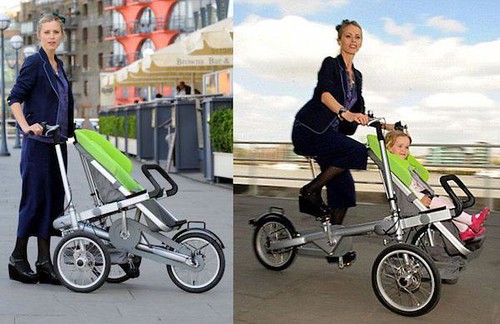
Source article from the UK Daily Mail.
Average Rating: 4.4 out of 5 based on 290 user reviews.
February 15th, 2012 | Permalink
Tags: bike, fun, transportation
Is DC’s proposed 37-mile streetcar network perfectly planned already, or could a few tweaks to the routes improve the plan?
The Streetcar Land Use Study released last month identified about a dozen potential route changes that might improve the system’s already impressive effects on development. The proposed changes adjust the details of streetcar routes to provide better transit service to locations that have a lot of potential riders or could see new development.
The study stopped short of actually recommending any changes to the adopted network, but did suggest that as DDOT drills down into the specific details of route planning, it analyze each of these segments further.
K Street at Union Station

Somewhere near Union Station, the H Street streetcar will shift north 2 blocks before continuing west along K Street into downtown. The adopted plan calls for the shift to take place on New Jersey Avenue, but it could be done on 1st Street NE instead.
The 1st Street alignment would provide more direct service through the heart of the emerging NoMa office district, and to the huge Greyhound bus station at the corner of K and 1st. The downside is this alignment would remove direct access to the New Jersey Avenue Walmart, which is sure to become a major destination.
Poplar Point and downtown Anacostia

Poplar Point could one day be the location of a large new mixed-use development. Unfortunately the location is isolated by I-295, and difficult to access by foot or transit. Meanwhile, the MLK Avenue alignment through downtown Anacostia is narrow, and proving difficult to work with. Adding tracks to Poplar Point would add a major new attraction and remove stress from a likely choke point.
Southwest Waterfront

Like Poplar Point, the Southwest Waterfront is primed for major redevelopment. The planned streetcar alignment follows Maine Avenue, but shifting it one block over to Water Street would put it closer to the action, for basically no additional cost. There is so much pavement in this area that it may be a location where a dedicated transit lane is possible. If that is the case, DDOT should put the streetcar wherever they can get the lane.
Buzzard Point

Diverting the M Street SW/SE streetcar to Potomac Avenue would more directly serve Nationals Park and much of the associated nearby development. Unfortunately, doing so would add a lot of travel time for other riders, since it would turn what is currently planned to be a direct 3-block trip along M Street into a lengthy 10-block crescent. Additionally, M Street is one of the few locations where a dedicated transit lane may be possible, so diverting from it would forfeit that possibility.
14th and 15th Streets

Shifting the streetcar from 14th to 15th through downtown DC would be easier to construct from an engineering perspective, and would put the streetcar on a busy tourist street close to the White House. The study does not discuss the implications of running a streetcar on the same street as a cycle track, but if they can both be accommodated it would certainly be an impressive sight.
7th/9th couplet

The adopted streetcar plan calls for both both north and southbound streetcars to use 7th Street south of Gallery Place. Shifting the southbound trains to 9th Street would mirror existing bus service, reduce impacts on congested 7th Street, and permit use of the 9th Street transit lane.
Washington Hospital Center

DDOT’s streetcar plan calls for half the streetcars on one line to take Irving Street and the other half to take Michigan Avenue. Eliminating this split around the hospital campus and instead routing the streetcar through the campus, or along its southern edge, would save tens of millions of dollars and have no serious negative effect on service to the hospital or any future development at the McMillan Sand Filtration site.
It would take away convenient service from the Armed Forces Retirement Home and development the home plans at the edge of its property, but that may not happen for some time and the size is still in question.
Columbia/Harvard couplet

The adopted plan calls for bi-directional streetcar travel along one-way Columbia Road. Adding tracks to Harvard Street and operating one-way couplets through Columbia Heights would be similar to the way existing bus service uses Irving and Columbia as couplets, and would improve operations. It would be worth exploring mirroring bus service exactly and using Irving instead of Harvard for eastbound tracks, but doing so would require more complicated engineering and may therefore be more difficult.
South Dakota Avenue and Fort Lincoln

Rerouting the eastern end of the Rhode Island Avenue streetcar to turn south on South Dakota Avenue and terminate at Fort Lincoln would bring service to potential redevelopment areas along South Dakota Avenue, as well as provide a convenient location for a maintenance facility. However, this would add significant new length and expense to the line, and would make it more difficult to ever extend rail service into Maryland.
Silver Spring

The Georgia Avenue line would end at Takoma Metro rather than Silver Spring in order to keep the entire line within the District of Columbia. However, Silver Spring is a tremendously more compelling destination, with very high density and one of the region’s most important transit transfer stations. Rerouting to Silver Spring would almost certainly be worth the cost, if Maryland is willing to participate as a partner.

Wisconsin AvenueWisconsin Avenue has repeatedly come up as a potentially strong streetcar corridor that was left out of the adopted plan. There is less opportunity along Wisconsin Avenue for substantial infill growth, which makes it a lower priority for streetcar service. However, if the system does expand significantly beyond its current scope, this would be a natural corridor.
Rosslyn
Curiously, the land use study does not consider the possibility of extending the Georgetown streetcar line across the Key Bridge into Rosslyn. Certainly such an extension would be compelling, for many of the same reasons as the Silver Spring extension. It could be that the cost or engineering challenges of extending rail to Rosslyn are prohibitive, but it seems odd to leave out any discussion of the possibility.
Cross-posted at Greater Greater Washington.
Average Rating: 4.8 out of 5 based on 240 user reviews.
February 10th, 2012 | Permalink
Tags: streetcar, transportation
|
Media


Site
About BeyondDC
Archive 2003-06
Contact
Category Tags:
Partners
|


