Special Features

Image Libraries

Blog

Based on feedback from this post, I’ve modified the map of Metrobus routes that use articulated buses.

Here is the updated route list.

  • Many peak period buses are articulated:
    • 70 and 71 – Georgia Ave in DC
    • Y series – Georgia Ave in MD
    • S1 – 16th St
    • X2 – H St
    • Z series – Colesville Rd (shown truncated on the map)
  • Occasionally articulated:
    • S2 – 16th St
    • J2 – East West Hwy / Old Georgetown Rd
    • C2 and C4 – University Blvd
    • K6 – New Hampshire Ave
    • R2 – Riggs Rd
  • Rarely articulated:
    • L2 – Connecticut Ave
    • 5A – Dulles Airport
    • B30 – BWI Airport

Feel free to post additional comments / corrections.

Average Rating: 4.9 out of 5 based on 228 user reviews.

July 30th, 2012 | Permalink
Tags: bus, development, transportation


click to enlarge
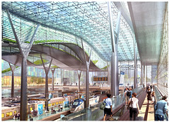
Proposed main level train room.

Amtrak released its long range plan for Union Station yesterday. If implemented, the proposed redesign will accommodate double the train service and triple the number of passengers as compared with the existing station.

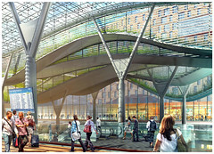
The plan looks pretty nice, and includes some beautiful features. Foremost among them is a new European-style train room that would be unprecedented in North America. Instead of boarding trains from a dim cavern below the parking garage, riders would board from a brightly-lit glass enclosure.

Despite that, I can’t help but feel a little bit nervous about the whole thing.

A hundred years ago almost every major American city had a beautiful train station. Unfortunately many were destroyed during the 20th Century. Of those that survived, the vast majority are mere shells of their former selves. Washington Union Station is one of the only exceptions. It’s an absolutely beautiful historic building that remains active, vital, and functioning as an extremely busy train station. In my opinion it’s the best intercity rail station in America.

And so when plans come forward to dramatically change it, I get a little bit worried. So many of the country’s train stations have been ruined by redevelopment, it’s clearly a dangerous business.

But Union Station does legitimately need to be expanded. It’s a bottleneck that limits all of its rail users: Amtrak, MARC, VRE, even Metro. More capacity is needed, if not today then surely by this plan’s ~2030 timeline. So more slots for more trains have to be accommodated somehow.

So Union Station must expand, but carefully. The key concern with any potential redesign must be the continued health and vitality of the historic building. Amtrak must not allow its greatest station to suffer the fate of so many of its one-time peers. Expansion is fine, but the old building must not be replaced, even in function. Supplement, but don’t take over.

Thanks to historic preservation there is no danger that Washington Union Station will be bulldozed and replaced by a modern version, as New York’s famous Penn Station was. But there might be a danger that Washington would follow the example of Denver, where that city’s Union Station will soon be converted to a hotel, and all of its rail functions moved to new buildings directly behind the old depot.

The key demand for any expansion of Union Station must be that the original building continue to function as an integral part of the depot. Most Amtrak, MARC, and VRE passengers should continue to pass through it, and the concourse facilities should be as close as possible.

It’s true that many of the rail-related functions moved out of the original building decades ago. Nevertheless, the expansions so far have resulted in a seamless whole. Casual users don’t notice where the old building ends and the new one begins. Just about everyone passes through the original depot, which still includes ticketing, and remains where most internal Union Station circulation takes place.

Any expansion must work the same way.

So how does this new plan perform?

The general premise of the plan is to basically do two things: 1) Double the number of stub-end tracks on the main level, and 2) dramatically expand the lower food court level, adding new tracks and 2 additional waiting areas further north than the current concourse.


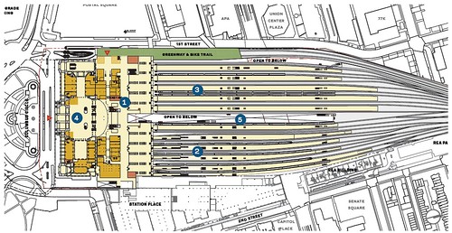
Proposed main level floor plan.

Proposed lower level floor plan, showing new concourses.

The main level concourse that was built in the 1980s will be renovated and enlarged. This is great news. It’s not a historic space, so renovating it is no loss (and will probably be a big improvement), and it is the most convenient location for a concourse to be accessed via the old building. These improvements should guarantee that the front of the building remains very important, and heavily used.

Behind the renovated front concourse, the existing train room will be replaced by a new European-style open version. This continues the existing layout, but with a vastly superior design. Thumbs up to that.

The two new lower level concourses will unfortunately serve to disperse users further away from the main building. Hopefully they will draw just enough people to remain busy themselves, but not so many that they become the new center of the station.

The middle concourse will be reserved for MARC and VRE. It does make sense to separate them from intercity traffic, so if there’s going to be a new concourse then this one makes sense.

The northernmost concourse will offer redundant access to all platforms. It’s there so users from NoMa don’t have to walk south to the main entrance and then backtrack north. As long as most of the station’s amenities remain in the front, this secondary access point will remain less convenient for most users, and therefore should not be a major problem.

The walkway connecting the two new northern concourses to the main building is called the center concourse. As the hub for two of the three boarding areas, this will surely become a busy area. It could threaten the old building’s vitality if too many rider amenities are moved from the front of the station to this walkway. The main ticket counter, for example, should remain in the old building. But as long as this walkway remains just a walkway, and does not take on the functions of a terminal, it should not be a problem.

All in all, there seems to be enough activity remaining in and near the old building to guarantee its continued use. There are lots of new things further north, but they appear to remain secondary to the front. These changes should make Union Station even better than it is now.

But I’m still a touch nervous. A lot will depend on the details of where rider amenities are located.

Here are more images from the report:


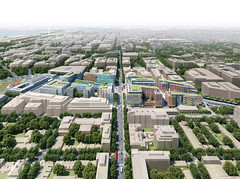
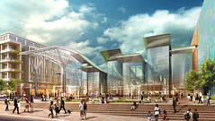
Overview of the entire development, including air-rights buildings.

Proposed new rear entrance, leading directly to the glass-enclosed train room.

Proposed new central concourse, as seen from approximately the current concourse-to-parking garage escalator.

Elevators leading from one of the lower concourses up into the train room.

Proposed new rear entrance.

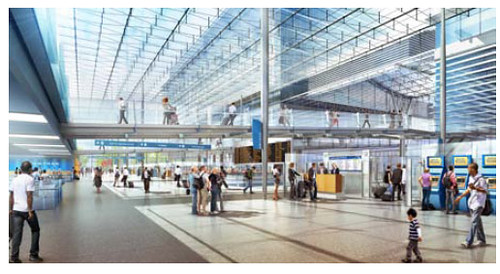
Proposed renovation to the existing stub-end concourse.

Average Rating: 4.9 out of 5 based on 289 user reviews.

July 26th, 2012 | Permalink
Tags: architecture, commuterrail, development, galleries, intercity, preservation, transportation


Articulated buses have been getting a lot of attention lately. WMATA has expanded their use, and prior to selecting a streetcar Arlington considered using them on Columbia Pike. But where do the long buses actually run?

Curious to answer that question, I set out to identify the routes where I’ve seen articulated buses. This map shows the effort so far, but it’s probably incomplete. I don’t have any actual data on this, only what I’ve noticed anecdotally, and what a few other people have told me.

Take a look, and use the comments to let me know what I’ve missed or gotten wrong.

List of routes shown as “most articulated”:

  • 70 – Georgia Ave in DC
  • Y series – Georgia Ave in MD
  • S1 – 16th St
  • X2 – H St
  • J2 – East West Hwy / Old Georgetown Rd
  • Z series – Colesville Rd (shown truncated on the map)

Routes shown as “occasionally articulated”:

  • L2 – Connecticut Ave
  • S2 – 16th St (S4 also shown on map, will be removed with next draft)
  • C2 and C4 – University Blvd
  • K6 – New Hampshire Ave

Average Rating: 4.9 out of 5 based on 160 user reviews.

July 25th, 2012 | Permalink
Tags: bus, question, transportation


click to enlarge
Portland’s streetcar.

Arlington officially adopted its streetcar plan for Columbia Pike last night, during a marathon County Board meeting that lasted until 1:30 am.

Technically, the County Board voted to approve streetcar as the “Locally Preferred Alternative” for the project’s alternatives analysis. That analysis is a study process required by the federal government for jurisdictions hoping to land federal funding for new rail or BRT lines. Now, with the “LPA” in hand, Arlington can begin to seek funding.

The final vote was 4-0, with one abstention.

Average Rating: 4.9 out of 5 based on 247 user reviews.

July 24th, 2012 | Permalink
Tags: streetcar, transportation


Take a look at this neat urban design feature, from Columbus, Ohio.

High Street is probably Columbus’ best urban street. It runs through most of the city’s best walkable neighborhoods, and has one of the only good bus lines in the region. But there’s a problem: It crosses over I-670, resulting in a block-long overpass that no one could describe as pedestrian friendly.

So the city built a cap above the highway, and topped it with a building lined with shops. The result seems like just another city block.


This is the view from the sidewalk.


If you walk behind the building, you can see the highway rolling underneath.

Average Rating: 4.5 out of 5 based on 179 user reviews.

July 23rd, 2012 | Permalink
Tags: roads/cars, transportation, urbandesign


VDOT has an awesome flickr photo set containing aerial pictures of construction projects in Northern Virginia. Foremost among the pictures are the Silver Line and Beltway HOT lanes, but there are also aerial photos of several other smaller projects.

Here is the full gallery. A teaser is below.


Silver Line under construction in Tysons Corner. Photo by VDOT.

Average Rating: 4.6 out of 5 based on 189 user reviews.

July 20th, 2012 | Permalink
Tags: galleries, metrorail, roads/cars, transportation


This is a village in the Faroe islands. The landscape is so alien. I think it’s fascinating.


Photo by Joannis.

Average Rating: 4.6 out of 5 based on 203 user reviews.

July 19th, 2012 | Permalink
Tags: galleries


Problem: Commuter buses that run on highways without HOV lanes are often stuck in the same congestion as cars, and there’s either no money, room, or political will to build a dedicated busway.

Solution: Let buses bypass highway congestion by running on existing highway shoulders.

Shoulders have limits; merging at exits would be complicated, bus speed would be limited for safety reasons, and buses would have to move in to the general lanes whenever someone needs the shoulder for a break down or police action. Still, shoulder running can improve transit travel times by a lot.

There are a handful of examples of this practice around the DC region today, most notably on the Dulles Access Road between the Beltway and I-66, but the idea could be easily implemented on a much wider scale.

Today at the Transportation Planning Board, members asked that a working group be convened to discuss further applicability of this idea in our region. The working group would consist of elected officials and staff members from the various jurisdictions and DOTs. Obviously their work has yet to start, but in a few years we might look back on today’s meeting as the beginning of a regional highway bus lanes network. Wouldn’t that be nice.


Dulles Access Road shoulder, with sign indicating bus use at peak periods.

Average Rating: 4.8 out of 5 based on 226 user reviews.

July 18th, 2012 | Permalink
Tags: bus, roads/cars, transportation


click to enlarge
A: Light rail doesn’t need as much separation as metrorail, and can fit in narrower spaces.

Question: Why do most cities that are building new rapid transit systems use light rail, instead of heavy metrorail?

Someone asked me that question over the weekend. Here is my answer:

It basically comes down to cost and flexibility. Light rail is cheaper and more flexible, so cities use it unless they absolutely need the higher capacity of metrorail.

Heavy metrorail is built to be 100% grade separated all the time. That means nothing ever crosses the tracks. If you want to cross the tracks (as a pedestrian or in a car), you need a bridge or tunnel on a different level so that you can do it while trains are using the tracks simultaneously. This makes metrorail very expensive, and limits where you can put rail lines. In very highly urbanized areas such as downtowns, your only options are basically in a subway or elevated above ground.

Light rail on the other hand works at-grade, which is to say you can allow streets, sidewalks, and pedestrians to cross the tracks. That makes it much cheaper, and much easier to locate/build. You can run light rail along any street you want, basically. This is especially beneficial in downtown areas, where instead of a massively expensive subway or el, you can simply run light rail on the surface. You might opt to give it a dedicated lane or you might opt to run it in a lane mixed with cars, but either way it’s easier and cheaper than a subway/el.

And of course, light rail can run fully grade-separated in a subway or an el if you want it to, it just isn’t required. So if you find that you need a metrorail-level of capacity for part of your line, but not for all of it, you can still use light rail. Metrorail doesn’t offer that kind of flexibility. It has to be grade-separated all the time.

So light rail is generally slower and has lower capacity, but is much easier to fit into cities and is much more affordable. So you would only go to the expense/trouble of building metrorail when you need that very highest level of capacity.

Think of metrorail as being like the transit equivalent of an interstate highway, where there are no traffic lights and there’s not supposed to be anything that impedes traffic. On the other hand, think of light rail as being more like the transit equivalent of a big arterial road, or like Fairfax County Parkway.

Average Rating: 5 out of 5 based on 254 user reviews.

July 16th, 2012 | Permalink
Tags: lightrail, metrorail, question, transportation, urbandesign


Highway overpasses are not usually considered to be beautiful, but sometimes they are. Take a look at these examples from suburban Denver. All the images are via Google Street View, so forgive the quality.


Average Rating: 4.4 out of 5 based on 244 user reviews.

July 13th, 2012 | Permalink
Tags: architecture, roads/cars, transportation, urbandesign


Media


Site
About BeyondDC
Archive 2003-06
Contact

Search:

GoogleBeyondDC
Category Tags:

Partners
 
  Greater Greater Washington
 
  Washington Post All Opinions Are Local Blog
 
  Denver Urbanism
 
  Streetsblog Network


BeyondDC v. 2013d | Email | Archive of posts from 2003-2006