|
Special Features


Image Libraries


|
|
Blog
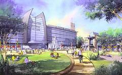
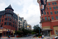
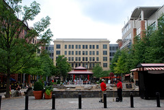
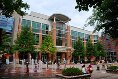
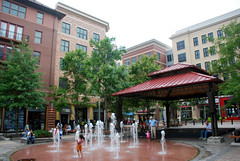
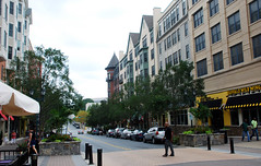
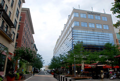
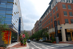
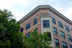
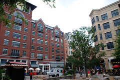
Rockville is a real city with a real downtown. During the 20th Century it was gobbled up by the expanding Washington suburbs, but it has a legitimate historic core. Like many cities, its historic downtown was gutted during the urban renewal days, and is only now recovering. The Rockville Town Square project is a redevelopment that covers a few blocks of the larger downtown area. Although it’s new, and still has a bit of a “plastic” feeling, it’s very well designed and more “real” feeling than many new-built town centers elsewhere.
The project is laid out around a comfortable central plaza. The buildings are all uniform height, giving the project a European feel. Although they were all built at the same time as part of the same project, the architecture of each building is unique, and the styles vary from traditional to modern.
Here are some loose pictures, taken in 2011.
Average Rating: 5 out of 5 based on 197 user reviews.
August 31st, 2012 | Permalink
Tags: architecture, galleries, urbandesign

|
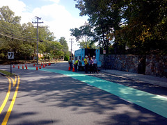
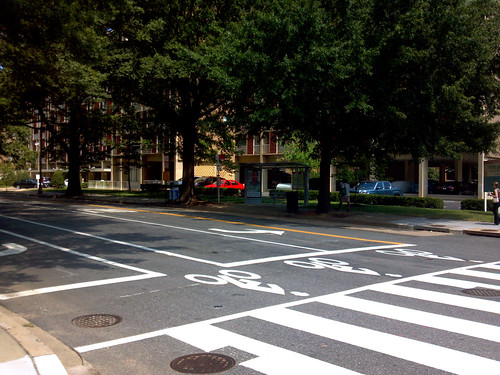
Arlington’s first green bike lane. |
When bikes and cars mix, the key to safety is for both bicyclists and car drivers to be aware of their surroundings, and expect to encounter each other. Therefore the safest bike lane is one that’s highly visible, so that car drivers see it and expect bikes to be using it.
With that in mind, progressive cities around the world have been painting bike lanes green at key locations, to make them more visible. Within the US, green painted lanes are especially common in Portland and New York. DC has exactly one, on 15th Street, SE.
And now Arlington is installing several, at important conflict points where cars and bikes cross. Its first one went in Wednesday afternoon, at the corner of Military Road and Nelly Custis Drive. If weather cooperates, 4 more will be installed around the county over the next few days.
This map shows all 5 of Arlington’s locations. They are Clarendon Blvd at 15th Street North, Wilson Blvd at Veitch Street, Lynn Street at 19th Street North, and 15th Street South across the Pentagon City Mall parking garage entrances. More could come later, at other similar conflict points.
Here is a set of 11 pictures of the first one being installed.
 Cross-posted at Greater Greater Washington. Cross-posted at Greater Greater Washington.
Average Rating: 4.4 out of 5 based on 275 user reviews.
August 30th, 2012 | Permalink
Tags: bike, galleries, transportation
One thing that always bothers me about bike maps is how complex they are, especially when it comes to the best trails. What would a different kind of bike map look like?
Here’s an example of what bothers me: Compare Google’s highway map for the DC region with its bike map at the same scale. Notice on the highway map how the most important roads pop out, with clearly defined lines that easily show the best driving routes. Then notice how the bike map is a muddled mess of criss-crossing lines and minor trail segments.
At the local scale all those little trail segments can be important. But at the regional scale it’s useless information. At the regional scale I just want to know where the best and longest trails are, in relatively simple geographic terms. I want a highway map for bike trails.
So I threw together a very simple one, showing only the most important of the regional trails. I didn’t put a huge amount of thought into it, nor did I spend a lot of time making the map as pretty as it could be. This is just an exercise.
A more dedicated and useful mapping effort might be to overlay the “bike highways” identified here atop the official regional maps, using a thick line that clearly indicates the importance of these routes. A stronger effort might also establish some objective standards for which trails to include, since arguments could be made that I left some important ones out.
But at the very least, this should help to visualize where the major biking corridors of the region exist.

Cross-posted at Greater Greater Washington.
Average Rating: 4.7 out of 5 based on 223 user reviews.
August 28th, 2012 | Permalink
Tags: bike, development, maps, transportation
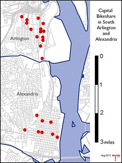
Alexandria will soon become the third jurisdiction in the region with Capital Bikeshare stations. This is exciting news, because it extends the reach of the bikesharing network, and because it will greatly improve the last-mile problem for transit riders hoping to get to the Alexandria waterfront from Metrorail.
But bikesharing works best when stations are in close proximity to a lot of other stations. Since Alexandria’s 8 initial stations constitute a pretty small network on their own, it’s worth looking in to just how far away their stations will be from the rest of the Capital Bikeshare system.
The next closest stations are in Arlington, in the Crystal City / Potomac Yard area, just north of the Alexandria city border. As the map at right shows, there’s about a two-mile gap between Arlington’s southern-most station and Alexandria’s northern-most one.
Despite the gap, Old Town is the natural place for Alexandria to put its first bikesharing stations. That was a good decision. But at two-miles distant from the rest of the Capital Bikeshare network, Alexandria’s system will function mostly like an island. Ridership will be limited until connectivity increases. Therefore, the city should find funding to the fill in that gap, and provide stations in Del Ray and southern Potomac Yard, as soon as possible.
Average Rating: 4.8 out of 5 based on 237 user reviews.
August 28th, 2012 | Permalink
Tags: bike, transportation
|
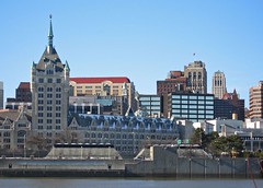
Albany skyline. Photo by Daniel Langer on flickr. |
I’ll be on vacation from August 19-26, in upstate New York. Although I’m not actually spending my vacation in Albany, odds are I’ll be there at least one day. Any suggestions for what to see? My previous experience there consists of a layover and transfer at the Rensselaer Amtrak station.
There won’t be any blog posts here on BeyondDC while I’m gone. I will tweet periodically though.
Meet Market
In the mean time, drop by the DC Meet Market at 15th and P on Saturday the 18, where I’ll be manning a booth for my wife’s shop, selling urbanist-, DC-, and geography- themed paper goods.
Average Rating: 4.5 out of 5 based on 191 user reviews.
August 17th, 2012 | Permalink
Tags: events, site
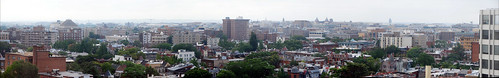
The Hinckley Hilton is one of the most prominent buildings in Northwest Washington. It offers nifty panoramic views of the central city. Thanks to some visiting relatives, I got a chance to photograph the view.
OK, so Washington’s skyline is kind of boring. But still. Who doesn’t love a good view?
Click here for the full-size version, and here for a version with key landmarks labeled.
Average Rating: 4.5 out of 5 based on 211 user reviews.
August 15th, 2012 | Permalink
Tags: galleries
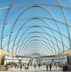
Amtrak made a big splash last month when they released plans to overhaul DC Union Station, but did you know that many other cities are also making big investments in their rail depots? The list, and the renderings, are pretty impressive.
Los Angeles Union Station opened in 1939 and is often referred to as “last of the great railway stations in America.” And for the past 3/4 of a century that superlative has been largely correct. As rail travel declined, so did rail station design. During the latter half of the 20th Century, many cities replaced their grand historic depots with so-called “amshaks”, cheap and awful buildings that have more in common with utility sheds than anything else.
But now that’s all changing, and soon Los Angeles will have to give up its title.
Look at all these plans from big cities around the rest of America:
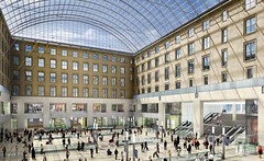
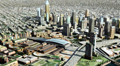
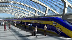
New York Moynihan Station | project website
This plan would shift New York’s Penn Station over one block, to reconceive the historic post office building next door as a station building. |
 |
 |
 |
 |
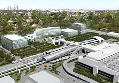
Atlanta MultiModal Passenger Terminal | project website
Future new intercity rail station. |
 |
 |
|
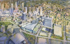
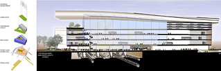
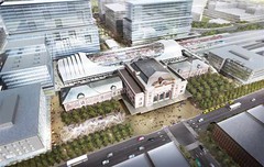
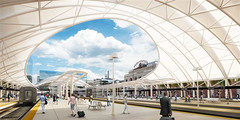
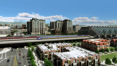
Denver Union Station | project website
Renovation of historic depot and addition of a new train room, service Amtrak, regional, and ski trains. |
 |
 |
 |
|
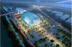
Miami Central Station | project website
New multimodal station at Miami airport, integrating Amtrak with local rail. Not downtown, but will become the main transit transfer point in the city. |
 |
 |
|
|
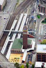
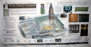
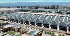
Seattle King Street Station | project website
Major restoration of historic depot, which had degraded significantly. |
 |
 |
|
Charlotte Gateway Station | project website
New station integrating Amtrak with local rail. |
 |
 |
|
|
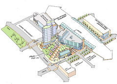
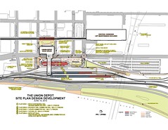
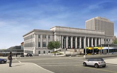
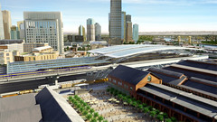
Saint Paul Union Depot | project website
Renovation of historic depot for Amtrak and local use. |
 |
 |
 |
|
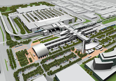
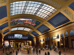
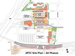
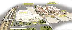
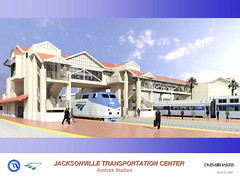
Jacksonville Regional Transportation Center | project website
Four-block project integrating Amtrak with local service. A series of new station buildings will be added surrounding the historic depot, which is used as Jacksonville’s convention center. |
 |
 |
 |
|
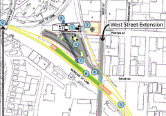
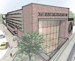
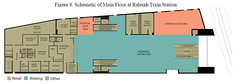
Raleigh Union Station | project website
Adaptive reuse of a historic warehouse to become a new Amtrak station. |
 |
 |
 |
|
Thanks to the California High Speed Rail (CAHSR) project, that state has several major station projects in planning.
Los Angeles Union Station | project website
Expansion of existing historic station, to include a new train room for CAHSR. A final design has not yet been picked, so multiple options are still under consideration. |
 |
 |
|
|
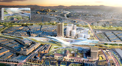
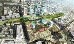
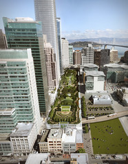
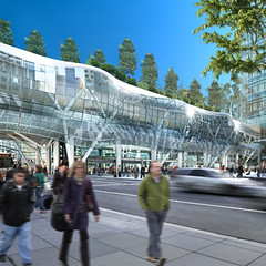
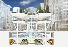
San Francisco Transbay Terminal | project website
Reconstruction of an existing bus station to handle future California High Speed Rail, as well as local regional/commuter rail. |
 |
 |
 |
|
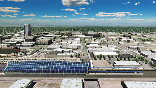
Sacramento Station | project website
New station for CAHSR. |
 |
 |
|
|
San Jose Diridon Station | project website
New train room at existing station to integrate CA HSR with local rail. |
 |
 |
 |
|
Anaheim Regional Transportation Intermodal Center | project website
New station for CAHSR. |
 |
 |
|
|
Fresno Southern Pacific Station | project website
New train room at historic depot for CAHSR. |
 |
|
|
Average Rating: 4.8 out of 5 based on 186 user reviews.
August 14th, 2012 | Permalink
Tags: architecture, development, galleries, intercity, metrorail, transportation
Bike waiting zone, spotted today in DC at 4th and I, SW.
Who knew this was here and didn’t tell me?
Average Rating: 4.9 out of 5 based on 248 user reviews.
August 13th, 2012 | Permalink
Tags: bike, transportation
Back in 2010, WMATA produced a 15-minute bus map that showed bus routes with frequent service throughout the day. That map was just for planning purposes, but it’s such a useful idea that I took the next step, and turned it into a more user-friendly diagram.
In addition to Metrobus routes, this map also shows other frequent bus services in the region, including DC Circulator, Bethesda Circulator, and the King Street Trolley.
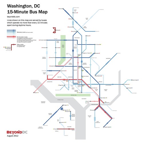
Cross-posted at Greater Greater Washington.
Average Rating: 4.4 out of 5 based on 239 user reviews.
August 10th, 2012 | Permalink
Tags: bus, featured post, maps, transportation
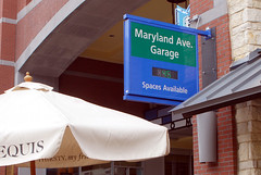
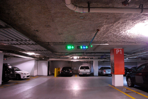
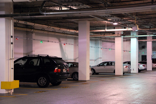
Here’s an idea: Put a sensor in every parking space within a big garage, capable of reading whether or not a vehicle is parked there. Attach a couple of lights to each space and rig them to display green if the space is open, and red if it’s in use. Feed the info to a central computer that counts up the open spaces and displays the number on a sign outside the garage, as well as on displays at the end of each parking aisle.
That system exists. Drivers benefit from it at a handful of garages around the DC region, most notably at BWI Airport and in downtown Rockville. It’s a neat concept that reduces drivers’ need to circle looking for a space, and therefore reduces congestion, fuel-loss, time-loss, and annoyance.
I don’t know how much it costs, but it sure is a nifty system.
Here are some photos showing how it works, from downtown Rockville:
Average Rating: 5 out of 5 based on 166 user reviews.
August 8th, 2012 | Permalink
Tags: galleries, roads/cars, transportation
|
Media


Site
About BeyondDC
Archive 2003-06
Contact
Category Tags:
Partners
|


