|
Special Features


Image Libraries


|
|
Blog
Simply put, the H Street streetcar goes from Union Station to the Anacostia River. But really its route is more complex.
This unofficial schematic shows the line in much more detail, including where it runs in the curb lane versus the middle lane, where there are track crossovers, and the layout of the railyard.
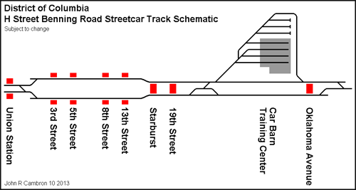
Schematic by John R. Cambron AKA Sand Box John.
 Cross-posted at Greater Greater Washington. Cross-posted at Greater Greater Washington.
Average Rating: 4.8 out of 5 based on 197 user reviews.
November 27th, 2013 | Permalink
Tags: streetcar, transportation

Today in transit nerdery, take a look at this Capital Transit articulated bus from 1948.
According to the original description, this is a demonstration run of a bus model Capital Transit never actually used for passengers. The photo shows the Calvert Street turnaround, which is still used today.
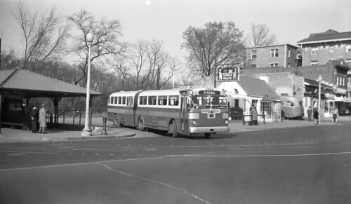
Original photo by Robert S. Crockett. Copied by flickr user rockcreek.
Average Rating: 4.6 out of 5 based on 203 user reviews.
November 26th, 2013 | Permalink
Tags: bus, history, transportation
For streetcars to move through traffic, rail tracks have to be free of parked cars. To keep them that way, the rules of the road must be crystal clear for drivers.
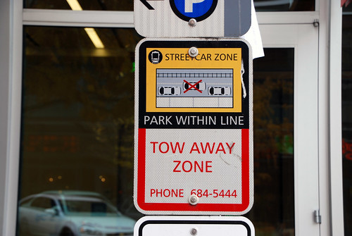
Streetcar parking zone sign, Seattle.
Last week DDOT used a truck for a test-run of the H Street streetcar route, and because of illegally parked cars, the going was slow. But other cities with similar streetcar layouts, like Seattle and Portland, have had a lot of success keeping their lanes clear. How do they do it?
With constant and clear communication to drivers, like the sign pictured here, and with strong enforcement.
Any time you take pavement away from cars, there’s a learning curve. Drivers accustomed to doing as they please have to change behavior. That’s to be expected, and it doesn’t happen on the first day you run your first test truck. But most drivers do fall in line, once they understand what’s changed. That’s how streetcars have worked in other cities.
And if all else fails, ticketing cameras mounted on streetcars, like in San Francisco, would solve any remaining problem in a hurry.
Cross-posted at Greater Greater Washington.
Average Rating: 5 out of 5 based on 264 user reviews.
November 25th, 2013 | Permalink
Tags: roads/cars, streetcar, transportation
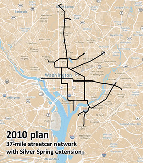
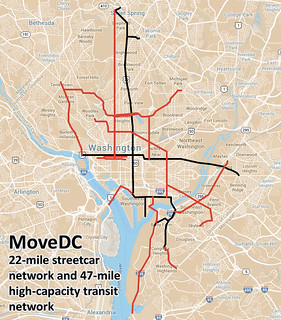
In the latest draft of DDOT’s MoveDC plan, the 37-mile streetcar network originally planned in 2010 becomes a 69-mile “high capacity transit” network.
The new 69-mile network would include DC’s initial 22-mile streetcar system, plus 47 more miles of either streetcar or BRT.
 |
 |
| 37-mile network from 2010, and latest MoveDC 69-mile proposal. Base maps from Google. |
The 47-mile network, shown in red on the map, would include 25-miles of dedicated transit lanes, regardless of whether those lines are eventually built as bus or rail. The dedicated lanes would be on 16th Street, North Capitol Street, I-295, M Street SE & SW, and I and H Streets downtown.
Curiously, the proposed streetcar line on Rhode Island Avenue from the 2010 plan isn’t carried forward into MoveDC.
The new plan shows the 14th Street streetcar shifting over to 7th Street, although the details of that line are still in flux. It could still end up on 14th.
Finally, MoveDC also notes several potential extensions to Maryland and Virginia, anywhere a proposed DDOT line approaches the District boundary. Perhaps most notably, there are potential connections across Long Bridge into Arlington, down I-295 to National Harbor, and to Silver Spring.
For Metrorail, MoveDC includes WMATA’s proposal for a new loop subway line through DC, connecting Rosslyn on one end and the Yellow Line bridge on the other.

Map from BeyondDC, using base map from Google.
Overall this is a progressive and ambitious proposal, although the removal of Rhode Island Avenue raises questions. It’s still a draft, so you can comment via the WeMoveDC website.
Cross-posted at Greater Greater Washington.
Average Rating: 4.9 out of 5 based on 175 user reviews.
November 22nd, 2013 | Permalink
Tags: BRT, master planning, streetcar, transportation
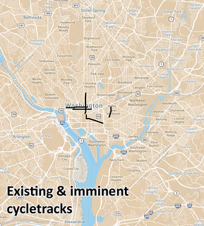
DC could one day have 70 miles of protected bike lanes, if the latest proposal from DDOT becomes reality.
The proposal comes as part of the latest draft of MoveDC, DDOT’s master plan. It’s still only a proposal, and has not been approved by the DC Council. But what an exciting proposal it is!
 |
 |
| Existing & proposed DC cycletracks. Base map from Google. |
And that’s not all, just for bikes. The proposal also includes over 60 miles of new off-street trails, and another 70 miles of new regular bike lanes.
Of course, it’s easy to adopt great plans and harder to accomplish them. DDOT is still struggling to implement the M Street cycletrack, after all. But one must start with a plan, and this appears to be an extremely progressive plan.
Tomorrow I’ll share the latest recommendations for transit.
Cross-posted at Greater Greater Washington.
Average Rating: 4.4 out of 5 based on 196 user reviews.
November 21st, 2013 | Permalink
Tags: bike, master planning, transportation
The recent work up and down the Washington Monument afforded some unique looks at the structure, including this one of the very tip. It’s made of aluminum, which at the time of the monument’s construction was one of the rarest materials available.
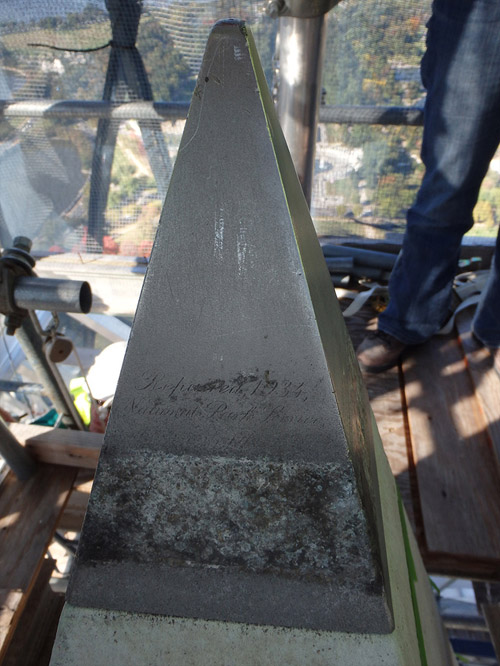
The top of the Washington Monument. Image originally from NOAA, via Gizmodo.
Average Rating: 4.6 out of 5 based on 153 user reviews.
November 20th, 2013 | Permalink
Tags: architecture
Last week Capital Bikeshare installed its 300th station. Quite an accomplishment! With stations now spread from Shady Grove to Alexandria, I thought it would be interesting to map their distribution, to see which parts of town have the most.
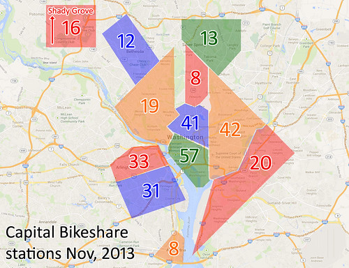
Bikeshare station distribution. Base map from Google.
Cross-posted at Greater Greater Washington.
Average Rating: 4.6 out of 5 based on 177 user reviews.
November 19th, 2013 | Permalink
Tags: bike, maps, transportation
|
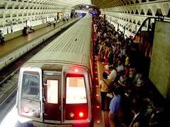
Packed Metro platform. |
Following a week of terrible Red Line Metro service, WMATA is offering refunds to riders who were inconvenienced. That’s a nice gesture, and perhaps it’s appropriate as a special measure when the same customers are hit with so many unexpected delays in such a short time. But in general, refunds are not the answer to Metro’s woes.
Yes, customers deserve to receive the service they’ve paid for, and yes, it’s satisfying to hold WMATA financially accountable when it doesn’t meet expectations. Those are the arguments in favor of refunds, and admittedly they’re compelling.
But if WMATA actually gave refunds every time there was a breakdown (which as we all know is unfortunately frequently), what would the side effects be? As always, follow the money.
For one, it would slow Metro’s reconstruction efforts, by diverting funding away from maintenance work. This painful period of single tracking and service interruptions would likely last years longer.
That’s bad enough, but consider WMATA’s likely response the next time there’s an unexpected rush hour breakdown. Instead of allowing thousands of passengers to continue entering the system and paying fares after the breakdown starts, only to be due refunds later, Metro would probably start to simply shut down entire lines. After all, you can’t demand a refund if you were never allowed to enter in the first place.
So on days like Wednesday, instead of bad service Metro riders might be left with no service at all. I don’t think that’s better.
At some point WMATA does need to be held accountable, so perhaps it was appropriate to offer refunds this week. But Washingtonians should neither demand nor expect a refund every time we have to wait for single tracking. Ultimately, improving Metro service back to the point where these delays don’t happen so often is what we really want. Frequent refunds wouldn’t help that goal.
Cross-posted at Greater Greater Washington.
Average Rating: 4.5 out of 5 based on 157 user reviews.
November 15th, 2013 | Permalink
Tags: funding, metrorail, transportation
Every day 33 bus routes converge on H and I Streets in downtown DC, making it the busiest bus corridor in the DC region. According to a WMATA report, a contraflow bus lane on H Street would dramatically improve travel times for both transit riders and car drivers.
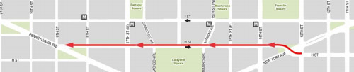
Potential H Street contraflow bus lane. Image from WMATA.
At peak times, one bus per minute travels along H or I. At off-peak, it’s a bus every two minutes. Today, all those buses mix with car traffic on both H and I Streets, which slows them down. Meanwhile, all those buses make several stops to pick up and unload passengers, which slows down car traffic trying to use the same lane.
Moving all the buses to H Street, which is less congested, and giving buses in the westbound direction a separated lane, would speed up both modes.
Since H Street is one-way going east, westbound buses would need a contraflow lane. There are no contraflow bus lanes in the DC region today, but they do work well in other cities around the US.
Contraflow bus lane in Pittsburgh.
In its report, WMATA also studied bus lanes on both H and I Streets, as well as a traffic management alternative that wouldn’t provide bus lanes, but would optimize traffic signals for buses. All the alternatives improved bus travel, and all of them either improved or maintained current car travel. But the H Street contraflow alternate provided the best combination of benefits, for relatively low cost.
Ultimately DC owns these streets, so the decision to actually implement bus lanes on them rests with the District, not WMATA. But Metro’s report could push DDOT to begin its own study process.
Seems like a good idea.
Cross-posted at Greater Greater Washington.
Average Rating: 4.4 out of 5 based on 295 user reviews.
November 14th, 2013 | Permalink
Tags: bus, roads/cars, transportation
As of this morning, the first streetcar wires are up on H Street.
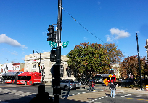
Span wire on H Street.
DDOT began stringing head span wires this morning around 7:00 am. Head span wires run perpendicular to the tracks. They’re different than the contact wires, which run parallel to the tracks and directly power trains. The contact wires will go up next, in the coming weeks.
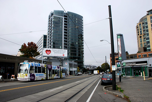
Streetcar in Seattle, showing both span wires and contact wires.
Cross-posted at Greater Greater Washington.
Average Rating: 4.4 out of 5 based on 197 user reviews.
November 13th, 2013 | Permalink
Tags: streetcar, transportation
|
Media


Site
About BeyondDC
Archive 2003-06
Contact
Category Tags:
Partners
|


