|
Special Features


Image Libraries


|
|
Blog
In recent years there has been a lot of discussion about raising DC’s building height limit. Today that discussion moved into the realm of official policy-making, as Congress announced it will study the issue. Any change to the height limit would need Congressional sign-off.
In general I think the height limit should be raised subtly, in key places for key reasons, based on careful planning. I’m in favor of using taller buildings to incentivize more development where we want it, but don’t think it would be wise to simply eliminate the limit completely.
That’s sounds simple, but the issue is pretty complex. Here are some key points, with links to more expanded discussion:
- Uptowns: Raising the limit in places like Anacostia and Tenleytown would encourage them to develop as uptowns, like Arlington and Bethesda.
- Negatives: Raising the limit in downtown DC would increase pressure to tear down historic buildings, and decrease the pressure to fill in parking lots and other underused properties.
- Tall =/= dense: Counterintuitively, midrise development is often more dense than skyscrapers.
- Residential bonus: Giving developers a height bonus in exchange for building apartments instead of office would increase the vitality of downtown.
- Do it, but carefully: We should raise the height limit with a scalpel, not a hatchet.
- Trade-offs: Despite economic advantages, there are non-economic trade-offs about raising the height limit that we can’t ignore.
- Be practical:: We should consider how to realistically improve the city’s regulations, not stake out dogmatic extremes.
Average Rating: 4.6 out of 5 based on 241 user reviews.
November 8th, 2012 | Permalink
Tags: government, land use, master planning, preservation, urbandesign

|
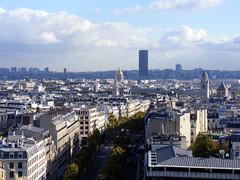
Arlington, urbanizing. |
Salon.com recently interviewed me for a story about emerging suburban downtowns. Here are some snippets:
Fact: People want to live in walkable urban places. Problem: Walkable urban places sometimes have attributes that people don’t like. Solution: Build new walkable urban places out in the suburbs. Result: A whole new type of place that offers the city experience without the actual city…
Some of them are in places like Rosslyn and Bethesda — close-in suburbs that developed an organic urban physicality over time… But the newer ones are in towns as far away as Reston and Tysons Corner in Virginia…
Daniel Malouff, editor of the blog BeyondDC, sees these WalkUPs as more like “starter cities” for suburbanites. “A place like Reston can introduce people who have grown up with suburbia to the idea of urbanism, ” he says…
But does density and walkability alone make something urban? Though these outer-ring WalkUPs display many of the technical metrics of a city, most have an unmistakable suburban flavor…
But if WalkUPs promise an urban experience, it’s fair to ask what kind of urban experience they’re offering. “Any definition of urban you can think of, these places would qualify, ” says Malouff. “But there’s clearly a difference.”…
The discussion about the authenticity of newly-built urban places has been going on since at least the late 1980s, when New Urbanism started to become a thing. On the one hand, new-built town centers are usually a touch sterile (especially if they’re built by a single developer all at once), and often disconnected from other urban places. On the other hand, they get better with age, and even Adams Morgan was a new place once upon a time.
I agree with the criticism that these places can sometimes feel forced, especially the ones like Bowie Town Center that are basically malls without a roof. But given the reality that our metropolitan areas jumped the suburban shark decades ago, and that millions of suburbanites cannot be expected to convert to Jane Jacobs urbanists all at once, whatcha gonna do? What other solution is there at the regional scale, except for incremental change in the right direction?
Our metropolitan areas aren’t going to change overnight, and we wouldn’t want them to anyway (it wouldn’t feel “real”). If our regions are going to change, it will be an incremental change.
That’s what’s so ironic about these town centers. Individually some of them lack the organic progression that would make them feel real. But taken in the regional context they are a legitimate step in precisely that sort of progression, part of a decades-long evolution of our metropolitan areas.
So whatever legitimate and true criticism of them is leveled, they’re still a good and necessary thing. The challenge for urban planners in the 21st Century will not be how to fight against these town centers, but rather will be how to improve them, and how to incorporate them in to a working, interconnected region.
Average Rating: 4.9 out of 5 based on 295 user reviews.
September 24th, 2012 | Permalink
Tags: master planning, The New America
|
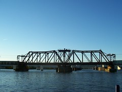
The Long Bridge. Photo by Monika & Tim via flickr. |
DC will soon kick off a new study, focused on potential replacement or expansion options for Long Bridge, the rail-only Potomac River bridge that carries Amtrak, VRE, and freight trains between DC and Virginia.
The bridge, which was originally built in 1904 and then substantially rebuilt in 1942, is a major bottleneck and capacity constraint on rail services in the region. It has only two tracks, which severely limits the number of trains that can move across the river. This study will be an opportunity to evaluate the need for more tracks, which if built could increase Amtrak and VRE service south of DC.
DDOT will also consider other modes. Would it make sense to add a bike trail to the bridge, or separate tracks for streetcars? DC and Arlington both have plans for streetcars near the river on either side of Long Bridge, so connecting them might make sense.
The study is just starting, so it will be a while before recommendations start to come out. But it’s definitely one to keep an eye on.
Average Rating: 4.6 out of 5 based on 226 user reviews.
September 12th, 2012 | Permalink
Tags: commuterrail, intercity, master planning, transportation
Rockville and Gaithersburg are nearly identical in many ways, and usually get along. But they aren’t happy with each other right now, as they fight over who will annex a property located in the narrow swath of unincorporated land between them. This fight shows how long-term planning works and why it is important.
The crux of their disagreement is that Gaithersburg wants to annex a piece of land near the Rockville border that Rockville has never annexed itself, but to which Rockville thinks it is entitled. The land is south of Shady Grove Road, which many people think of as the unofficial boundary between the two cities.
But what people think of unofficially is not the law. There are actually laws on the books that govern how annexation works. When the dust settles, Gaithersburg is going to win this fight, because Gaithersburg has proactively thought about its long term planning needs, while Rockville has been strictly reactive.
The State of Maryland requires incorporated cities to adopt a future expansion plan, showing areas that each city may want to annex in the future. The entire point of this requirement is to give cities the opportunity to show where their “unofficial” boundaries are, so that everyone can plan accordingly.
And whether Rockville cares to admit it or not, they never made any kind of claim to the land in question until after Gaithersburg claimed it for itself, despite many opportunities to do so. If Rockville thought itself entitled to everything south of Shady Grove Road, then Rockville should have used the state’s process to stake a legal claim.
Here are maps showing each city’s adopted expansion plans, taken from their respective growth plans:
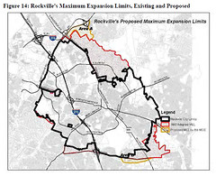
Rockville |
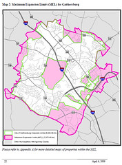
Gaithersburg |
The property in question is near the south-east corner of Shady Grove Road and Frederick Road (map).
The Gaithersburg plan was adopted in 2009, and clearly shows this property as part of Gaithersburg’s claim area. It’s possible Gaithersburg claimed the land even earlier, but at the very latest by 2009 they had declared their intention to the land. Meanwhile, Rockville’s plan shows that they didn’t start thinking about this property until 2010, and had even specifically excluded it from their expansion plan during their previous update in 2002.
If Rockville wanted this land, why didn’t they claim it in 2002? Or even before? If they really thought of Shady Grove Road as the boundary with Gaithersburg, why not make it official during any of the many updates to their expansion plan over the decades? Why wait until after Gaithersburg claimed it to express any interest?
Rockville didn’t plan for the long term, and Gaithersburg did, and so Gaithersburg is going to win. They are set to annex the property at tonight’s City Council meeting, and Rockville is powerless to stop it.
This is a good lesson to everyone. Proactively plan for what you want, or lose out to someone who did.
Average Rating: 4.6 out of 5 based on 156 user reviews.
August 6th, 2012 | Permalink
Tags: government, master planning
|
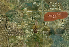
Mobil’s huge property, marked in red. Click to enlarge. |
In 1987 the Mobil gasoline corporation moved its corporate headquarters from New York to Merrifield, Virginia. It was a major coup for the DC region, and a big early step in the growth of Fairfax County as a major corporate base. In the style of the times and befitting a major corporation, they built and occupied a massive campus-style building, set back literally acres from any of the surrounding highways. The site is pictured at right.
12 years later, in 1999, Mobil merged with Exxon to form what is today the 3rd largest corporation in the world. ExxonMobil’s headquarters set up in Irving, TX, in suburban Dallas. The Merrifield office became the Downstream headquarters, directing refining, manufacturing and marketing.
And now they are vacating their 1.2 million square foot behemoth office building and consolidating their offices in Houston – the oil capital of America.
Apparently they are shopping the building to other prospective office tenants. Fairfax County says they don’t expect it to be vacant for long.
But should this building still be used? It’s a private fortress set in a huge forest, amidst an otherwise urbanizing area. It’s a dinosaur of 20th Century planning. Inefficient use of land, laid out to require everyone to drive, and surrounded by “open space” that’s impractical for anyone to use as an actual park. Bad bad bad.
On the other hand, it’s a huge piece of land at an absolutely great location. It would make a fantastic town center development. The land is too far from Dunn Loring Metro to be walkable, so it wouldn’t be a TOD, but it could easily accommodate a Reston Town Center or Shirlington-like development, which if not perfect would still be a big improvement over sprawl. And who knows, regional transportation planners are starting to discuss the possibility of light rail on Gallows Road (pdf, see page 2, item #8), so maybe in a few decades that transit connection will be there after all.
It’s unfortunate that the region will lose all the jobs associated with Mobil, but it would be even more unfortunate if this opportunity to redevelop one of the prime pieces of real estate in Fairfax County were missed.
Average Rating: 4.9 out of 5 based on 188 user reviews.
June 8th, 2012 | Permalink
Tags: economy, energy, lightrail, master planning, proposal, transportation
|
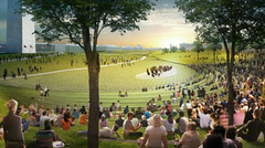
Proposed amphitheater. Design by OLIN + Weiss/Manfredi. |
The National Mall is not a perfect space. Although millions of people visit it each year, many sections are oversized and underused. It’s poorly integrated with the surrounding city, and its aging components are in need of maintenance. What can be done?
No one would propose demolishing the Mall, or seriously changing its basic character, but clearly there is room for improvement.
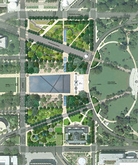
The Trust for the National Mall agrees. They sponsored a design competition to rethink 3 important sections of the Mall: Constitution Gardens, the Washington Monument grounds, and Union Square. The winning entries are filled with interesting ideas.
Constitution Gardens
|
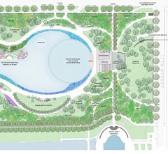
Design by Rogers Marvel Architects + Peter Walker and Partners. |
Many Washingtonians feel that Constitution Gardens is the best part of the Mall already. Certainly it’s the most unique, with its informal pond and romantic pathways. The winning design, by Rogers Marvel Architects + Peter Walker and Partners, will build on the gardens’ strengths to make it even better.
They propose to introduce a new pavilion at the east end of the existing pond. This pavilion would become the centerpiece of activity in the garden. It would contain a restaurant and a dock for model boating. In the winter, the eastern section of the pond would be used for ice skating.
These additional active uses are good additions, although one wonders if another ice skating rink can survive so close to the existing rink at the Sculpture Garden.
One negative aspect of this plan is that it actively turns its back on the street. It proposes to raise new hills along Constitution Avenue in order to “provide separation” between the park and downtown. This is entirely the wrong approach, and will contribute even more to the segregation of the city’s cultural amenities from the city’s residents.
Washington Monument grounds
|
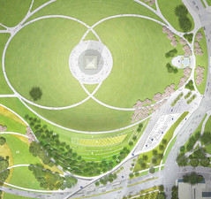
Design by OLIN + Weiss/Manfredi. |
In contrast to Constitution Gardens, the Washington Monument grounds are probably the worst section the Mall. The giant grass lawns are not destinations to anyone but a few softball players. Rather, they are long, empty voids that must be traversed.
The poor condition of the grounds is even more unfortunate because they are the geographic center of the monumental core. In theory this should be the most heavily-built and formal area of the Mall, but in reality it is the least.
The winning entry for this section, by OLIN + Weiss/Manfredi, is disappointing in its scope. Rather than address the fundamental deficiencies with the grounds as a whole, the design focuses closely on the southeast corner and largely ignores the rest.
To the designers’ credit, what they have proposed is excellent. They would replace the afterthought that is the existing Sylvan Theater with a wonderful new grass amphitheater. It would blend seamlessly with the surrounding landscape, would face and help to frame the Washington Monument, and would vastly improve the theater experience in every way.
They also propose a cafe and bookstore, to be built into the side of a small hill so that they appear as one with the rolling landscape. These are good additions that will improve the edge condition between park and city, and the proposed architecture is both appropriate and totally unique.
Union Square
|
Design by Gustafson Guthrie Nichol + Davis Brody Bond. |
Better known as the Capitol Reflecting Pool, Union Square suffers from many of the same problems as the Washington Monument grounds. It’s visually impressive, but usually empty. There’s not much reason for people to go except to pass through, and its monumental components are so oversized that they are a barrier to walking.
The winning design, by Gustafson Guthrie Nichol + Davis Brody Bond, does much to improve the situation.
They propose reducing the size of the reflecting pool and carrying additional pathways through the site, creating new connections with the Smithsonian area to the west.
They also propose to narrow Pennsylvania and Maryland Avenues, and to convert them from parking lots to more pedestrian-friendly streets.
Unfortunately, the garden areas north of Pennsylvania Avenue and south of Maryland Avenue are afterthoughts in this proposal. It would have been nice to see a new building on the north end of the site, mirroring the location of the US Botanical Garden. That area is a nether-zone between the Mall and Senate Park, and would be more valuable as the site for a future museum.
Next steps
The Trust for the National Mall does actually intend to build these designs. Fundraising will begin soon, and the first ribbon-cutting could take place as early as 2016.
That’s good news.
Overall, these ideas would improve the National Mall. It would still be an imperfect space, poorly connected to the living city around it. But it would, for the most part, be better than it is today.
 Cross-posted at Greater Greater Washington. Cross-posted at Greater Greater Washington.
Average Rating: 4.5 out of 5 based on 219 user reviews.
May 8th, 2012 | Permalink
Tags: development, master planning, urbandesign
|
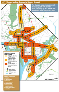
Streetcar impact on residential development demand. |
Will DC’s streetcar system be worth its $1.5 billion expense? A recent study indicates that the answer is a resounding yes.
One of the key differences between buses and streetcars is that streetcars induce land development. That benefits the city from a Smart Growth and urbanist perspective. It also turns out to be a big win for the city’s coffers.
The DC Office of Planning’s Streetcar Land Use Study was commissioned to determine the impact that the city’s planned streetcar network will have on development, and on city tax revenue.
The findings are, to put it mildly, extremely positive.
Positive impacts
According to the study, the great benefit of streetcars will be that they tremendously expand the number of households and business properties that are within walking distance of a rail station. With streetcars, the share of DC residents within a quarter mile of a rail stop will increase from today’s 16% up to 50%.
That will correspond to an increase in the value of properties along streetcar lines by $5-7 billion. Another $5-8 billion in new development can be expected, resulting in a total property value increase of $10-15 billion due to streetcars.
That would result in $238-291 million in new tax revenue for the city each year, after completion of the 37 mile streetcar network. At that rate it would take only 6 years for the city to recuperate the full $1.5 billion cost. After 6 years, the tax revenues would be pure profit.
Tax revenue isn’t the only benefit, of course. The demographic impacts are significant. Compared to a no-streetcars baseline scenario, over a 10 year period the streetcar network is anticipated to induce 6, 300-7, 700 new jobs in the District, up to 12, 000 new households, and up to 1.3 million square feet of new retail development.
That is a big deal.
The study goes on to conclude that these sort of dramatic results are only practical with streetcars.
Bus Rapid Transit (BRT) is often mentioned as a less expensive alternative to streetcars. However, according to the study BRT would require exclusive rights-of-way in order to begin to achieve some of the same benefits as mixed-traffic streetcars. The property acquisitions necessary to provide exclusive bus lanes would more than negate any cost savings achieved by using buses, and the impacts on development would still be less. At the end of the day, BRT would be neither cheaper nor as effective.
Meanwhile, the expense of Metrorail and light rail would make them cost prohibitive to use for such an extensive network. If the District wants 37 miles of new transit, they are not options.
Negative impacts
There are of course some negative impacts. The largest of which is the effect such a tremendous increase in development demand would have on affordable housing.
The study recommends that in order to mitigate that impact, a range of policy prescriptions will be necessary. Recommendations include upzoning certain areas so that supply can keep up with demand, mandating inclusionary zoning in new developments, and greater code flexibility to allow accessory dwelling units such as alley houses.
Another negative impact is that streetcars running on a curbside alignment preclude the possibility of converting parking lanes to travel lanes during the peak period. With curbside streetcars, parking lanes must be either permanent, or absent.
The report also mentions the complications inherent to bicycle-streetcar coexistence. It notes that quality bike infrastructure will be necessary along streetcar corridors in order to minimize conflict.
Funding mechanisms
Although federal funding may become available at some time, any realistic scenario for the funding of this network must include a substantial local contribution.
In addition to DDOT’s normal funding mechanisms, the study identifies potential other sources of streetcar construction funds. Developer contributions and Tax Increment Financing (TIF) appear to be the most promising.
Developer contributions may be possible where very large developments would benefit from streetcar services, such as at Walter Reed or the Southwest Waterfront. The city could negotiate for a contribution of a few million dollars, knowing that the value of the development will increase by a greater amount with the presence of a streetcar.
Tax Increment Financing has even greater potential to fund a very large percentage of the program. TIF is a process in which the city uses bonds to build the initial capital investment, then repays the bonds using the increase in property tax revenue.
The report estimates that using the TIF process, the District could realistically support $600-900 million in bonds. That would approximate to between 40-60% of the total $1.5 billion cost.
These funding strategies will have to be explored in greater detail, and the negatives associated with streetcars will have to be addressed. But if this study proves correct, streetcars are going to be a big, big win. A decade after the system is built the city will be a better and more livable place, construction debt will be repaid, and the tax revenue will be rolling in.
Cross-posted at Greater Greater Washington.
Average Rating: 4.7 out of 5 based on 270 user reviews.
February 1st, 2012 | Permalink
Tags: government, master planning, streetcar, transportation
The official DC Zoning and Comprehensive Land Use maps are incredibly detailed and useful tools that serve specific, necessary functions. They’re also incredibly complex and difficult to read at a glance. I wanted to see a map that showed DC’s land use in the very simplest terms, to know where the commercial streets are, to see how downtown might reasonably expand, and to see where redevelopment is most likely (commercial properties are more likely to redevelop than residential ones).
Therefore I produced the following map, using data downloaded from the DC GIS Catalog. It shows predominantly commercial areas in red, predominantly residential ones in yellow, and everything else in gray.
For those interested in Washington as a living and working city, this is the city at just about its most bare.

Average Rating: 4.4 out of 5 based on 277 user reviews.
April 25th, 2011 | Permalink
Tags: galleries, master planning
|

Germantown’s landmark giant globe may be repainted. |
I haven’t had much time for blogging this week, and today is busy too. But there’s a lot of Montgomery County news today, so let’s just shoot through it real quick like.
- The Montgomery County Fairgrounds are considering possible redevelopment scenarios with the City of Gaithersburg. The fairgrounds are smack in the middle of everything, within walking distance to stations on the MARC line and the future Corridor Cities Transitway, and right up against I-270. The redevelopment scenarios aren’t actual proposals, just illustrations of what could happen.
- County Executive Isiah Leggett – essentially the mayor of Montgomery County – has formed a transit task force charged with studying how to best advance bus and train projects in the county.
- Speaking of bus projects in the county, MTA’s new ICC bus routes are now running. There are two routes starting in Gaithersburg. One ends at Fort Meade and the other at BWI. Rides are free through March 14.
- A water tank in Germantown that’s painted like a giant world globe and is visible from miles away may be repainted. Officials haven’t decided yet whether to keep the tank a globe or to give it a different look, such as that of a baseball.
- Developers want to build a 75-foot-tall apartment building in downtown Kensington near the MARC station. The area has a 60-foot height limit, but the developers say they can’t make the project work without 15 more feet.
- Preparations are underway for construction at Lot 31 in downtown Bethesda, the large surface parking lot adjacent to Barnes and Noble on Woodmont Avenue. The parking lot will be replaced by an underground public parking garage with mixed-use buildings on top.
Average Rating: 4.4 out of 5 based on 279 user reviews.
March 2nd, 2011 | Permalink
Tags: bus, development, master planning, transportation
A number of libertarian blogs have picked up BeyondDC’s post showing before and after aerials of Southwest urban renewal and citing it as an example of why government city planning is inherently bad.
That’s a little like saying contemporary doctors are bad because once, long ago, tribal medicine men practiced voodoo and it didn’t work. Or it’s like saying international travel by contemporary airplane is impossible because the Wright brothers’ first plane only managed to fly a few yards. Simply put: Citing an obsolete example of something doesn’t make the contemporary version wrong.
There are lots of things wrong with contemporary planning (*cough* zoning), but the fact that planners made mistakes a half century ago isn’t one of them.
Average Rating: 5 out of 5 based on 206 user reviews.
January 31st, 2011 | Permalink
Tags: government, master planning
|
Media


Site
About BeyondDC
Archive 2003-06
Contact
Category Tags:
Partners
|