|
Special Features


Image Libraries


|
|
Blog
The National Building Museum tweeted this morning “Mathematician Blaise Pascal organized the first public bus line in 1662.”
Neat! But awfully vague. I went looking for more details, and found them in a 2008 article from Wired, which explains:
“The system started with seven horse-drawn vehicles running along regular routes. Each coach could carry six or eight passengers. Some sources specify three routes; others say there were six, and that one of them was a circular route.
The Carosses à Cinq Sous, or Five-Penny Coaches, were popular at first, but the novelty soon wore off. The system proved an idea ahead of its time. France was still a feudal society, with the Sun King at its apex. Nobility and gentry were allowed to ride the coaches, but not soldiers and peasants. The bus routes were out of business by 1675.
Regular bus service didn’t return to Paris until the early 19th century. Stagecoaches running short routes also began service around that time in London and New York City.”
So there you have it: Urban bus service in Paris 250 years before anybody thought to try it elsewhere. I wonder if the routes are mapped anywhere, or if that information is lost to history.
Average Rating: 4.9 out of 5 based on 236 user reviews.
March 22nd, 2011 | Permalink
Tags: bus, history, transportation

|
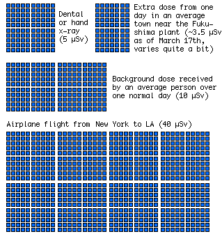
Radiation doses from a variety of sources.
Image from xkcd.com. |
Question: How might the disaster in Japan kill thousands of Americans? Answer: If anti-nuclear knee-jerk reactionaries are successful in using the Japanese tsunami as political leverage to scare Americans from investing in more nuclear power.
How so? Because every year 30, 000 Americans die from causes related to coal power production. Thirty thousand. That’s more dead Americans every year than in the entire Revolutionary War. It’s five times as many dead Americans as the Iraq and Afghanistan Wars combined. It’s almost twice the 18, 000 estimated Japanese dead from the tsunami disaster.
The longer we use coal instead of nuclear for the majority of our power generation in this country, the more Americans will die.
While we’re on the subject, let’s also talk about how dangerous the nuclear situation in Japan actually is. The chart at right is a snippet from a much larger one comparing radiation doses received for a variety of events. Note that the additional radiation doses received by Japanese citizens in villages near the breaking-down nuclear plant average less than a normal day’s dose (which is to say, they’re getting less than twice the normal daily dose that you get simply by living on the surface of the Earth). They’re less than you get from a dental x-ray, and much less than you get by flying on a jet from New York to Los Angeles.
It’s true that a relatively small number of workers at the plant are getting much higher doses, but the danger to the mass population is quite low. Meanwhile, thousands of people around the world continue to die every day as a result of coal power production. Far more than will ever die as a result of nuclear radiation from any of these Japanese plants. The 30, 000 American deaths per year attributed to coal average to more than 80 per day, which is nothing compared to the average of almost 1, 400 per day from China’s half-million annual coal deaths.
I don’t mean to imply that we should treat nuclear power lightly. Of course the only reason it’s so safe is that tremendous safety measures are involved. We should absolutely learn from the disaster in Japan to improve safety however possible. But one thing we cannot afford to do is allow knee-jerk reactionaries to stop America from expanding our nuclear production capacity. The human toll of such narrow thinking would simply be too great.
Average Rating: 5 out of 5 based on 208 user reviews.
March 21st, 2011 | Permalink
Tags: energy, environment, history
Writing about the ICC, as I did yesterday on BeyondDC and today for the Washington Post, is a nostalgia-filled experience for me. It’s a little like coming home.
The ICC was big news in Gaithersburg in the late 1990s, when I was in high school. Newspapers were filled with op-eds debating the merits of the road. I was fascinated, and read them all. I became a big proponent of the highway, because I was bored with suburbia and wanted Gaithersburg to be more like a big city, and in my suburbanite mind big cities had lots of big highways.
Of course I was wrong about what constitutes a big city, and about what relieves traffic congestion, and about a lot of things, but one key epiphany was there: Transportation affects land use. Whoa.
And so it was that I became interested in transportation planning. And so it was that I started writing about it, in letters to the editor of the Gaithersburg Gazette.
So while my position on the ICC has evolved over time, I continue to have a soft spot in my heart for it. The ICC is what started me down the path that has brought me here, to BeyondDC, to the Washington Post, to Greater Greater Washington, and of course to that day job as a professional transportation planner.
I can’t help but be a little nostalgic.
Average Rating: 5 out of 5 based on 271 user reviews.
February 8th, 2011 | Permalink
Tags: history, roads/cars, site, transportation, washpostblog
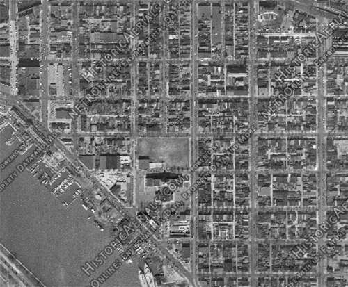
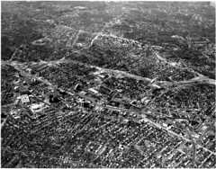
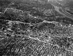
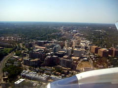
HistoricAerials.com is a really nifty web site. It’s a Google Maps-like page featuring aerial imagery from decades past. Its database includes images of Washington from several years dating back to 1949. It’s a fascinating way to watch neighborhoods change decade-to-decade.
The most visibly changed neighborhood in DC over the past 60 years has probably been Southwest, so I thought it would be interesting to look it up. Until the 1950s Southwest was a vintage rowhouse neighborhood, urban in every way and filled buildings from the 18th and 19th Centuries. Of course, mid-century planners could have none of that, so under the auspices of urban renewal it was almost completely bulldozed, and replaced by towers-in-the-park.
Here is Southwest in 1949, before it was “fixed”:
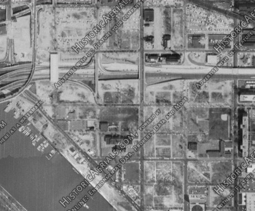
Here is the same view 14 years later, in 1963:
By 1979 the new Southwest was complete:
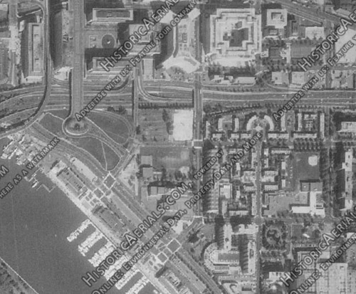
As if that weren’t sad enough on its own terms, things got even worse in other cities around the country. At least Southwest was rebuilt, albeit it in an inferior, too-suburban form. The same can’t be said for some neighborhoods in places like Detroit and Saint Louis, which through either misguided renewal efforts or simple neglect have gone from bustling to simply not there anymore.
Average Rating: 4.8 out of 5 based on 164 user reviews.
January 10th, 2011 | Permalink
Tags: galleries, history, preservation
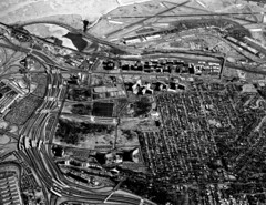
Arlington’s commercial corridors are so urban and bustling these days that it’s hard to imagine them as suburban strip highways, but until construction of the Metrorail brought a wave of transit oriented development, suburban strips is exactly what they were.
The changes along the corridors (and the stability of the surrounding neighborhoods) are clearly visible thanks to a fascinating set of historic aerial images taken in the 1970s, posted to the new Arlington County planning department flickr page.
Consider these examples, side by side with contemporary aerials taken by M.V. Jantzen, Arlington County planner Andrew D’huyvetter, and myself. Click through for larger versions of each image.
 |
 |
| Ballston, with I-66 under construction |
| |
 |
 |
| Clarendon |
| |
 |
 |
| Courthouse |
| |
 |
 |
| Crystal City |
 |
 |
| The Orange line corridor |
| |
 Cross-posted at Greater Greater Washington. Cross-posted at Greater Greater Washington.
Average Rating: 4.7 out of 5 based on 299 user reviews.
November 4th, 2010 | Permalink
Tags: galleries, history
|
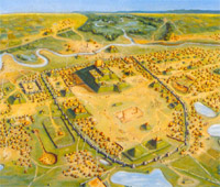
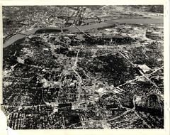
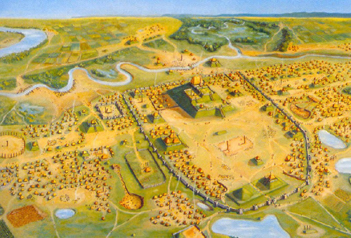
Cahokia: The National Mall of the pre-Columbian United States |
As an older, walkable city with a baroque street grid and no skyscrapers, Washington is sometimes thought of as one of the more European-like cities in America. That may be true, but I think our city can lay claim to an even more interesting title: The most distinctly Native American city in the country.
Obviously Washington is not Santa Fe. There is not a strong Native American cultural influence here. Physically however, Washington bears a strong resemblance to most of the large native cities that populated this continent before the arrival of Columbus.
The key similarity is the National Mall. Archaeologists have discovered that every large native city of any importance had an over-sized ceremonial center populated by palaces, government offices, historic monuments, ball courts, and religious pyramids. The National Mall may not have the religious importance that native centers had, but the basic idea was the same. They are all the ceremonial heart of the city and state.
Cahokia, the largest native city ever built in what is now the United States, had a ceremonial center. Tenochtitlan, the largest Aztec city, had one. Tikal, the most important city-state of the classical Maya, had one.
So did Teotihuacan, Chichen Itza, Winterville, virtually every large native city in North America. The list is dozens of cities long.
Meanwhile, no contemporary American city besides Washington has a ceremonial center the likes of the National Mall. San Francisco and Denver have monumental civic centers, while Cleveland, Detroit, Indianapolis, and a host of other cities have central plazas, but only Washington has a monumental core as large and central to the city as the Mall. Only the Mall is comparable in scale to the centers of the large native cities.
While cultural influences may ultimately trump urban layout, it’s certainly interesting that Pierre L’Enfant would unknowingly design a new capital city with such traditionally American features.
Luckily, there was no architectural establishment around to call it faux historic kitsch.
Average Rating: 4.7 out of 5 based on 258 user reviews.
September 29th, 2010 | Permalink
Tags: architecture, history, urbandesign
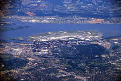
While looking up information on the Arlington County website for last week’s post about Rosslyn Metro, I discovered these historic aerial images of Rosslyn.
The first, from 1953, shows Rosslyn as a historic neighborhood. The second and third show it in the midst of high rise redevelopment.
Fascinating stuff.
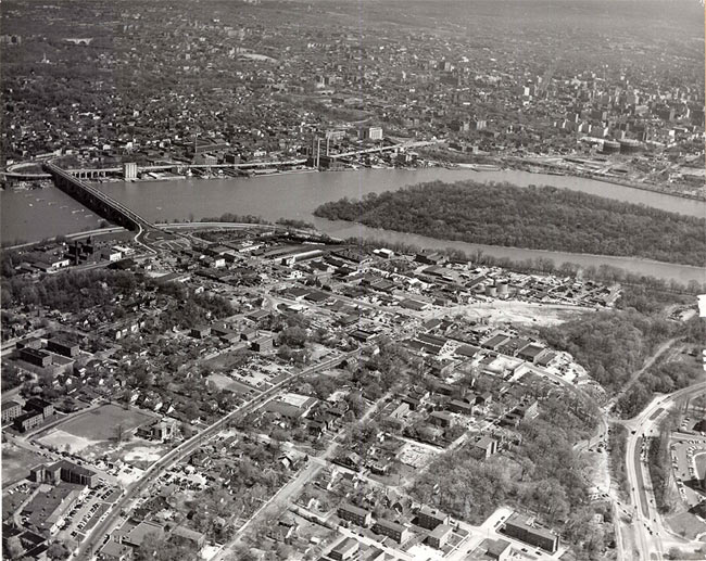
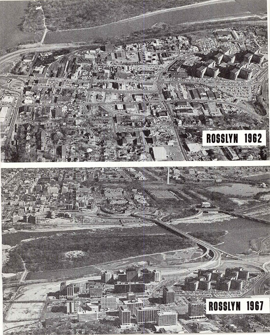
Images from Arlington County. Originals here and here.
Average Rating: 4.6 out of 5 based on 246 user reviews.
September 28th, 2010 | Permalink
Tags: galleries, history
|
No thanks |
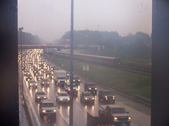
Today is Car-Free Day. For me, so was yesterday and the day before. I have now been car-free for more than 10 years, ever since January, 2000.
It all started when I went to college. I had a car in high school, a beat-up Civic, but didn’t take it with me to school in Colorado (go Buffs!). I spent most of my four years in Boulder living in the University Hill neighborhood, a student ghetto that is one of the most functionally urban places in the Mountain Time Zone. I walked to most destinations, and rode Boulder’s fabulous bus system to the rest. I didn’t bike much, but a lot of other people did.
When I returned east during breaks, I couldn’t help but notice how much better Washington’s urbanity was than that of Boulder or Denver. I knew that what I was doing in Boulder could be done here even more easily. I graduated, found a job in Fairfax, and moved to Ballston – the closest suitably urban place to my job. Later I moved to a new work place in Arlington and a new home in Northwest DC, making the car-free life even easier.
From time to time over the past 10 years I’ve considered buying a car. I’m not a zealot, just practical, and I haven’t taken the car-ownership plunge because I continue to find owning a car to be more hindrance than help. Most of my trips are simply easier to make on foot, bike or transit. When the need arises, I rent cars through ZipCar or Enterprise, but except for making out-of-town trips the need rarely arises. When it does, it doesn’t take much sitting in traffic or circling for parking to remind me why I like being car-free.
Ultimately, the car-free lifestyle has been more convenient for me, on top of more healthy, more affordable, and more green. I’m glad I gave city living a try 10 years ago, and can’t imagine going back.
To the thousands of people giving car-free life a try, today’s events are a reminder that life doesn’t have to revolve around cars. You don’t have to spend hours a day stuck in traffic, or looking for parking. There is an opt-out. You can take it. People do, and life goes on.
Average Rating: 4.4 out of 5 based on 287 user reviews.
September 22nd, 2010 | Permalink
Tags: history, transportation
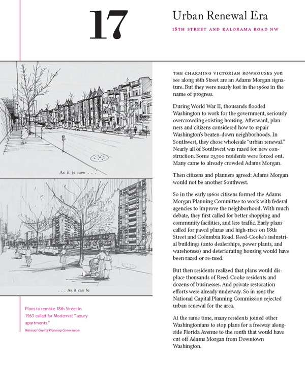
Given the post earlier this week about Washington’s unbuilt highways, I thought it would be interesting to republish this discussion of mid-century urban renewal from the Adams Morgan Heritage Trail Booklet. The booklet is available free to download from Cultural Tourism DC, and is similar to the historic marker on the sidewalk in Adams Morgan.
Click the image to download the booklet in pdf form.
Average Rating: 4.5 out of 5 based on 184 user reviews.
July 2nd, 2010 | Permalink
Tags: architecture, history, master planning, preservation, urbandesign
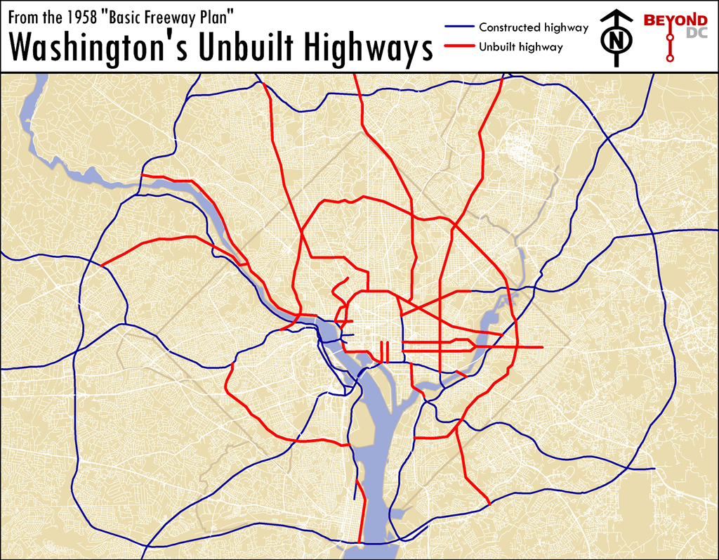
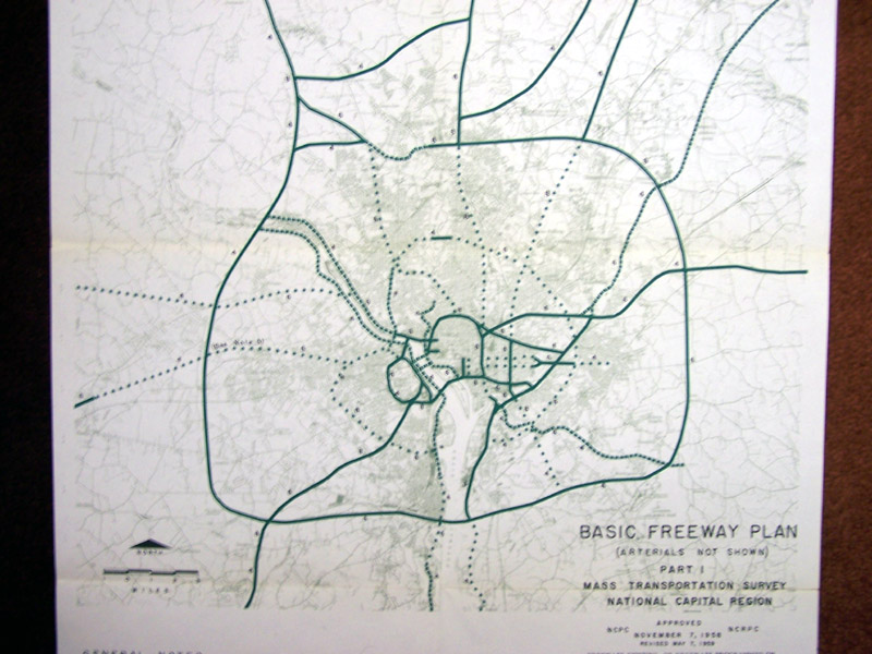
This is a map of the Washington that almost was. If mid-century planners, dedicated as they were to driving and the clearance of historic neighborhoods, had their way. It is a map of the highway network proposed for Washington during initial planning of the Eisenhower Interstate System, in 1958.
Each of these canceled highways, shown in red on the map, has its own story. Some were canceled due to civic activism, others because later proposals in the 70s preempted them, and others due to good ol’ fashioned sanity. Because they were never built, entire neighborhoods that might have been wiped out were saved, downtown was never physically cut off from its surroundings (except to the south), and millions of dollars were reallocated to construction of the Metro. Because these highways were canceled, Washington is the beautiful, walkable, vital city that we know and love today.
Most other American cities weren’t so lucky. Their highways were built, their neighborhoods demolished, and their downtowns converted to parking lots.
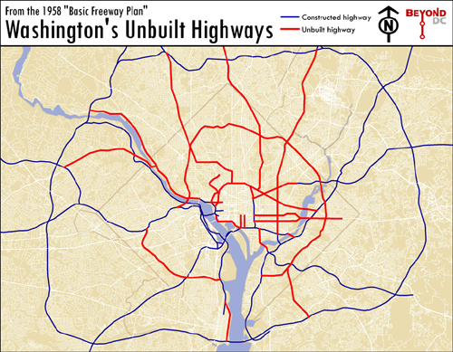
Map based on 1958 Basic Freeway Plan.
Click to enlarge.
Average Rating: 4.4 out of 5 based on 292 user reviews.
June 30th, 2010 | Permalink
Tags: featured post, history, roads/cars, transportation
|
Media


Site
About BeyondDC
Archive 2003-06
Contact
Category Tags:
Partners
|


