|
Special Features


Image Libraries


|
|
Blog
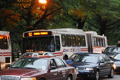
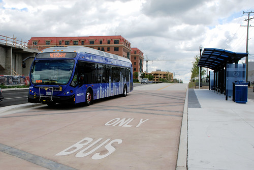
Bus rapid transit will come to Richmond in 2018. The long-planned Broad Street BRT project won a federal TIGER grant this week to cover half its cost, allowing the project to move forward into final design and construction.
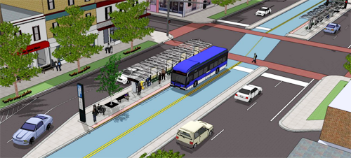
Rendering of Broad Street BRT. Image from the Greater Richmond Transit Company.
Broad Street is Richmond’s most successful transit corridor, and main bus spine. It runs through or near most of Richmond’s densest urban neighborhoods and most important central city hubs. It’s the natural place for rapid transit.
The BRT project will run from the Willow Lawn shopping center in suburban Henrico County, through Virginia Commonwealth University and downtown Richmond, all the way to Rocketts Landing on the city’s east side.
It will use a mix of dedicated curbside bus lanes and a median busway through the busiest sections of the central city, with mixed-traffic operation on either end.
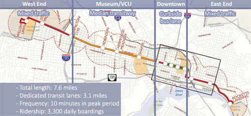
Map of Broad Street BRT. Original image from the GRTC.
Projections say the BRT line will carry about 3, 300 riders per day. That’s low compared to the standards of a transit rich metropolis like DC, but it’s huge for a place like Richmond, where there are only about 35, 000 total daily bus riders in the entire region.
 Cross-posted at Greater Greater Washington. Cross-posted at Greater Greater Washington.
Average Rating: 4.4 out of 5 based on 152 user reviews.
September 11th, 2014 | Permalink
Tags: BRT, bus, transportation

Earlier this year Columbus, Ohio launched CBUS, the Columbus Circulator. It’s a special overlay bus route running along the main street through the city’s densest, most urban neighborhoods. It comes every 10 minutes, has a low (actually free) fare, and limited stops. Sound familiar?
Oh, and here’s a photo:
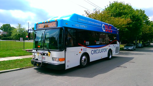
Photo by Darius Pinkston on Flickr.
Look familiar? That sweeping line, the destinations labeled on the side, “CIRCULATOR” in a modern sans-serif font right in the middle. It looks nothing like Columbus’ standard bus livery, but it is all very reminiscent of the DC Circulator.
In fact, Ohio transit advocates had the DC Circulator in mind during planning for CBUS.
Columbus isn’t alone, either. “Circulator” is spreading as an increasingly common brand choice for short-distance, high-frequency buses in mixed-use areas, especially near DC. There’s a Bethesda Circulator, a Tysons Circulator, and a Baltimore Circulator.
Just how far will this brand spread?
Cross-posted at Greater Greater Washington.
Average Rating: 4.9 out of 5 based on 300 user reviews.
September 10th, 2014 | Permalink
Tags: bus, transportation
The DC region’s first Bus Rapid Transit line opened this weekend. Metroway runs from Crystal City to Braddock Road, using a transitway along Route 1 in Alexandria.
> Continue reading at Greater Greater Washington
or
> See the full flickr set
Average Rating: 4.8 out of 5 based on 236 user reviews.
August 25th, 2014 | Permalink
Tags: BRT, bus, transportation
This bus is not in service. But it is running in Alexandria’s Metroway BRT corridor, presumably on a test run. It’s pretty exciting to see the region’s first BRT so close to starting.
The BRT opens for real on Sunday, August 24.
Cross-posted at Greater Greater Washington.
Average Rating: 4.8 out of 5 based on 187 user reviews.
August 12th, 2014 | Permalink
Tags: BRT, bus, transportation
DDOT isn’t yet willing to install a bus lane on 16th Street, but the agency is moving forward on a host of other improvements, and will study a bus lane next year.
The 16th Street bus line is bursting at the seams. It carries more than half of rush hour trips on 16th Street. But the buses are slow, and they’re so full that riders in the city’s close-in neighborhoods often can’t board.
Advocates have been pressuring for bus improvements on 16th Street since 2010. ANC Commissioner (and District Council candidate) Kishan Putta has championed the cause. Now, DDOT has adopted a 5-point plan to fix 16th Street.
Here are the 5 points:
Already complete: Signal optimization pilot program: In July 2014, DDOT retimed 44 of the traffic signals along 16th Street to improve their efficiency. After a few weeks of results, it appears to have sped up traffic (including buses). DDOT will continue to evaluate the results the rest of this summer.
August 2014: More articulated buses: Metro will reshuffle its bus fleet, to provide more long “accordion” buses on 16th Street. WMATA will move the articulated buses currently running on the Y series in Maryland to the 70 line in DC, then move the articulated buses currently on the 70 line to 16th Street. The Y series will have shorter buses, but they’ll come more often.
Fall 2014: Longer rush hour operations: DDOT is considering extending the hours of rush hour parking restrictions on 16th Street, to keep more travel lanes open up to an hour longer in each direction. That will keep two lanes open to moving traffic, including buses.
Mid 2015: Transit signal priority & full optimization: By mid 2015, DDOT will expand its signal optimization pilot program to the entire corridor, and install new software that instructs traffic signals to hold a green light a few seconds longer if a bus is about to pass through an intersection. That will speed up buses along the route, so they’re less likely to have to stop at red lights.
2015-2016: Bus lane study: Beginning in 2015, DDOT will begin a comprehensive study of transit improvements along 16th Street, including the potential for bus lanes and other long-term construction projects. The study will take about a year to complete, meaning 2016 is the earliest DDOT could install bus lanes.
None of these 5 points are new. DDOT has been working on them all for some time. But it’s good to have them listed all in one place.
Cross-posted at Greater Greater Washington.
Average Rating: 4.5 out of 5 based on 298 user reviews.
August 11th, 2014 | Permalink
Tags: BRT, bus, transportation
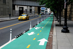
Simple plastic bollards and slight changes to lanes are enough to turn a regular bike lane into a cycletrack. Could the same trick work for bus lanes?
Bollard-protected bus lane in Washington state. Image from Zachary Ziegler on Vine.
DC’s 7th Street and 9th Street curbside bus lanes are famously dysfunctional. Cars use them at will, and pretty much always have. But it doesn’t have to be so.
The same tricks that work to protect bike lanes can also work to protect transit lanes. Plastic bollards, also known as flexposts, send a strong message to car drivers to stay out. The Virginia Department of Transportation even uses them on highways.
 |
 |
Flexposts on a Dulles Toll Road bus lane (left) and the Beltway (right).
Beltway photo from Google. |
Generally speaking, the same complications would exist for bus lanes as exist for cycletracks. Adding bollards takes up a couple of extra feet, parking for cars has to move a lane away from the curb, and you have to find a way to accommodate cars turning at intersections. But mixing zones and other clever solutions have solved those problems for cycletracks, and could work for bus lanes too.
And flexposts aren’t the only cycletrack lesson we can apply to bus lanes. Red paint helps transit lanes the same way green paint helps bike lanes.
 |
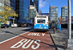 |
| Green means bike, red means transit. Bus lane photo from NYDOT. |
No matter how many special treatments like bollards or red paint an agency applies, median transitways will still function better than curbside transit lanes. Median transitways eliminate the right turn problem altogether (left turns are less common), and puts the transit lanes out of the way of parked cars, or cars pulling over to pick up or drop off passengers.
But median transitways take up more road space, because the medians have to be wide enough for stations. They simply can’t fit on all streets. Where that’s the case, tricks like these can help curbside transit lanes work better than the 7th Street bus lane.
Cross-posted at Greater Greater Washington.
Average Rating: 4.6 out of 5 based on 282 user reviews.
August 7th, 2014 | Permalink
Tags: bike, BRT, bus, lightrail, streetcar, transportation
When Phase II of the Silver Line eventually opens, it will carry passengers to two stations in Loudoun County. But that’s still a few years away. In the meantime, Loudoun is already sprucing up transit with more buses and improved park-and-rides.
On June 30, the Virginia Department of Transportation opened this snazzy new canopy at the Dulles North Transit Center, a bus depot near the future Route 606 Metro station.
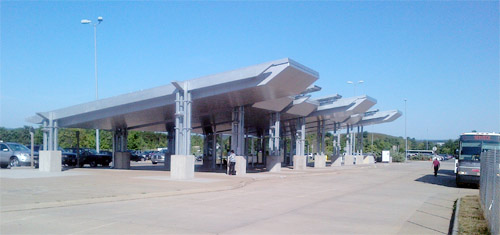
Photo by VDOT.
Average Rating: 4.7 out of 5 based on 156 user reviews.
July 29th, 2014 | Permalink
Tags: bus, transportation
Prior to 1976 the DC region had at least 60 miles of bus-only lanes, with even more proposed. This map shows where they were.
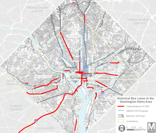
On the map, the red lines show existing bus lanes as of 1976. Blue and black lines show proposals that never materialized. The network reached throughout DC, Northern Virginia, and into Maryland.
Unfortunately, all the bus lanes were converted to other purposes after the Metrorail system was built.
It’s no coincidence or surprise that some of the old bus lanes were on the same streets where they’re now proposed again, like 16th Street and H and I Streets downtown. Those are natural transit corridors, with great need for quality service.
Will we ever get this system back? The region is off to a good start, with moveDC’s 25 miles of proposed transit lanes, and the upcoming Crystal City Potomac Yard Transitway. But the 60-mile system from the 1970s shows we still have a lot of work to do.
Cross-posted at Greater Greater Washington.
Average Rating: 4.5 out of 5 based on 283 user reviews.
July 7th, 2014 | Permalink
Tags: BRT, bus, maps, transportation
On San Antonio’s Primo BRT buses, cyclists bring their bikes inside the bus rather than lock them to the front. This speeds up loading and unloading, but reduces Primo’s overall passenger capacity.
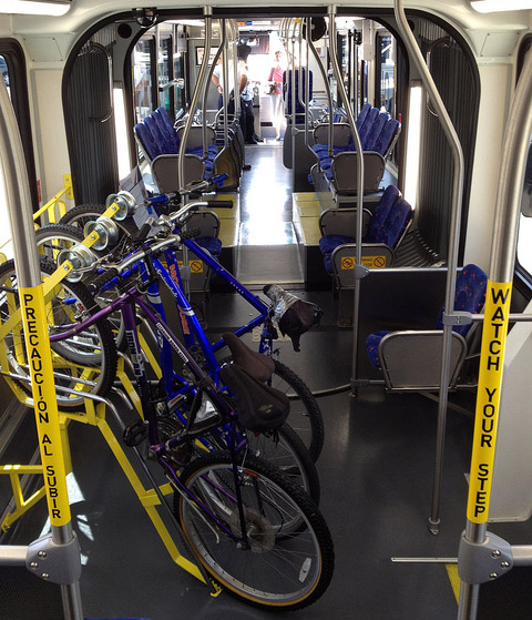
Bike racks on Primo bus in San Antonio. Photo by Stuart Johnson on Flickr.
Primo carries about 6, 000 passengers per day, compared to over 20, 000 per day on DC’s 16th Street line. So for Primo, the speed versus capacity trade-off tilts to speed.
In DC, our busiest bus lines generally won’t have that option. Although it may make sense in some places, like Montgomery County’s proposed BRT network.
For DC’s more crowded lines, where we cannot justifiably sacrifice limited bus capacity to bikes, rail’s greater spaciousness is an increasingly important advantage. With longer vehicles, we get both the speed advantage and the capacity advantage.
Of course to really speed up buses or trams, give them a dedicated lane. But even in places where that’s not practical, improvements like longer vehicles, more doors, interior bike racks, and off-vehicle fare collection can make a difference, regardless of mode.
Average Rating: 4.9 out of 5 based on 164 user reviews.
June 17th, 2014 | Permalink
Tags: BRT, bus, streetcar, transportation
The latest draft of DDOT’s citywide transportation plan, moveDC, calls for a massive expansion of transit and cycling facilities throughout the District, plus new tolls on car commuters. If the District adopts it, the plan will become one of America’s most progressive.

The moveDC plan summary map. All images from DDOT.
DDOT released the latest version of moveDC last Friday, launching a month long public comment period in anticipation of a DC Council hearing on June 27. Following that, the mayor will determine any changes based on the comment period, with final adoption anticipated this summer.
What’s in the plan
Amid the hundreds of specific recommendations in the plan, three major proposed initiatives stand out:
- A vastly improved transit network, with 69 miles of streetcars, transit lanes, and improved buses, plus a new Metrorail subway downtown.
- A massive increase in new cycling infrastructure, including the densest network of cycletracks this side of Europe.
- Congestion pricing for cars entering downtown, and traveling on some of DC’s biggest highways.
Transit

Proposed high-capacity transit network (both streetcars and bus). Blue is mixed-traffic, red is dedicated transit lanes.
The plan proposes to finish DC’s 22-mile streetcar system, then implement a further 47-mile high-capacity transit network that could use a combination of streetcars or buses. That includes 25 miles of dedicated transit lanes, including the much requested 16th Street bus lane.
Although the proposed high capacity transit corridors closely mirror the 37-mile streetcar network originally charted in 2010, there are several new corridors. In addition to 16th Street, moveDC shows routes on Wisconsin Avenue, both North and South Capitol Streets, H and I Streets downtown, and several tweaks and extensions to other corridors.
The plan endorses WMATA’s idea for a new loop subway through downtown DC, but explicitly denies that DC can fund that project alone.
MoveDC also shows a network of new high-frequency local bus routes, including Connecticut Avenue, Military Road, Alabama Avenue, and MacArthur Boulevard.
Bicycles
MoveDC also includes a huge expansion of trails and bike lanes, especially cycletracks.

Proposed bike network. The pink lines are cycletracks.
Under the plan, DC would have a whopping 72 miles of cycletracks crisscrossing all over the city. From South Dakota Avenue to Arizona Avenue to Mississippi Avenue, everybody gets a cycletrack.
Meanwhile, moveDC shows major new off-street trails along Massachusetts Avenue, New York Avenue, and the Anacostia Freeway, among others.
Tolls for cars
Congestion pricing is clearly on DDOT’s mind, with multiple proposals for new variable tolls in the plan.

Proposed downtown cordon charge zone.
The most aggressive proposal is to a declare a cordon charge to enter downtown in a car. This idea has worked in London and has been discussed in New York and San Francisco, but so far no American city has tried it.
Meanwhile, some of the major car routes into DC would also be converted to managed lanes. Like Maryland’s ICC or Virginia’s Beltway HOT lanes, managed lanes have variable tolls that rise or fall based on how busy a road is.
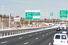
MoveDC proposes managed lanes on I-395, I-295, New York Avenue, and Canal Road.
What will the council think?
DDOT has produced a very strong plan, but is it going anywhere? The DC Council will discuss moveDC on June 27, at which time we’ll find out if the same people who pulled the rug out from under streetcar funding are interested in progressive policy-making, at least.
Even if DC does adopt this plan, whether the council will actually provide the funds necessary to build it is anybody’s guess.
Correction: An earlier version of this story reported the DC Council will approve or deny this plan. Authority to approve it actually rests solely with the mayor.
Cross-posted at Greater Greater Washington.
Average Rating: 4.7 out of 5 based on 229 user reviews.
June 2nd, 2014 | Permalink
Tags: bike, BRT, bus, government, lightrail, master planning, metrorail, roads/cars, streetcar, transportation
|
Media


Site
About BeyondDC
Archive 2003-06
Contact
Category Tags:
Partners
|