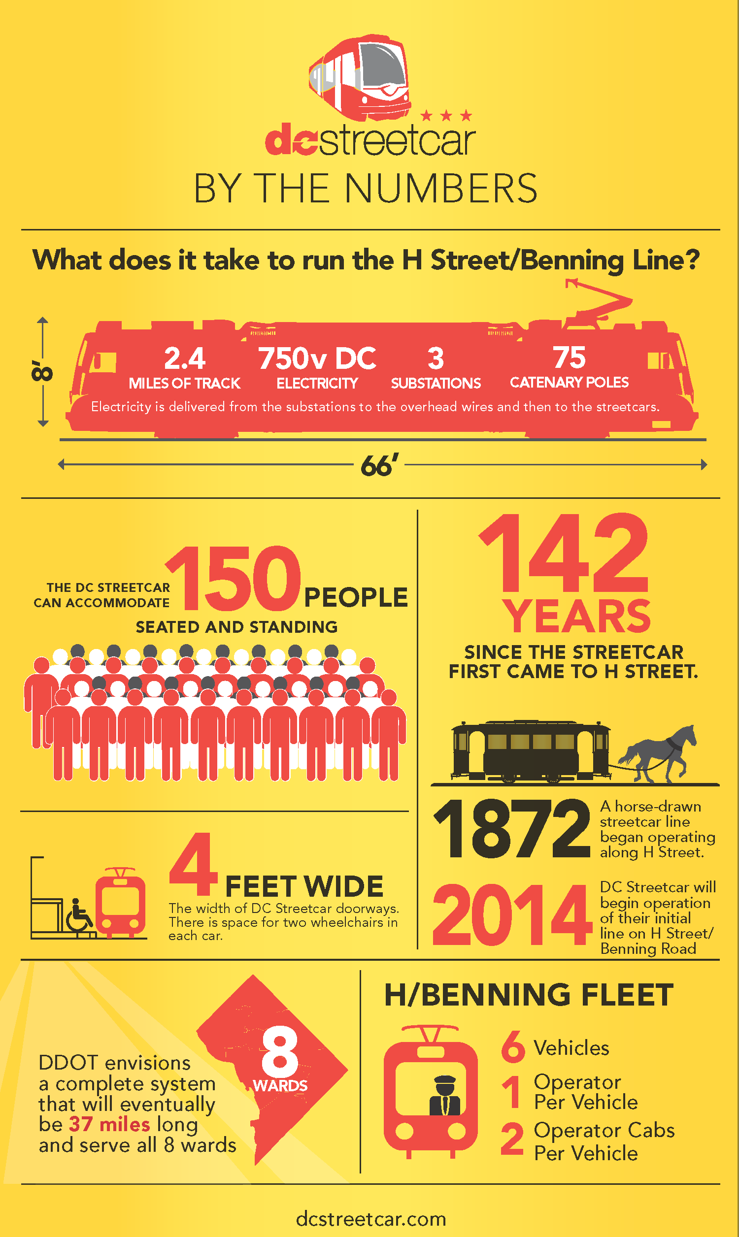
Average Rating: 4.8 out of 5 based on 267 user reviews.
June 12th, 2014 | Permalink
Tags: streetcar, transportation
|
|
Blog
Average Rating: 4.8 out of 5 based on 267 user reviews.
June 12th, 2014 | Permalink
 There’s more bad news for DC streetcars: The latest estimates show the H Street line may not open until early 2015. This isn’t an additional delay, but rather seems to be simply a more genuine timeline of how long the remaining work will take. That’s a step forward. Unfortunately, DDOT is still not being fully forthright about what’s going on.
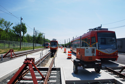 DC streetcars at the Anacostia testing & commissioning site. > Continue reading at Greater Greater Washington Average Rating: 4.8 out of 5 based on 164 user reviews.
June 5th, 2014 | Permalink
The latest draft of DDOT’s citywide transportation plan, moveDC, calls for a massive expansion of transit and cycling facilities throughout the District, plus new tolls on car commuters. If the District adopts it, the plan will become one of America’s most progressive.
 The moveDC plan summary map. All images from DDOT. DDOT released the latest version of moveDC last Friday, launching a month long public comment period in anticipation of a DC Council hearing on June 27. Following that, the mayor will determine any changes based on the comment period, with final adoption anticipated this summer. What’s in the plan Amid the hundreds of specific recommendations in the plan, three major proposed initiatives stand out:
Transit
 Proposed high-capacity transit network (both streetcars and bus). Blue is mixed-traffic, red is dedicated transit lanes. The plan proposes to finish DC’s 22-mile streetcar system, then implement a further 47-mile high-capacity transit network that could use a combination of streetcars or buses. That includes 25 miles of dedicated transit lanes, including the much requested 16th Street bus lane. Although the proposed high capacity transit corridors closely mirror the 37-mile streetcar network originally charted in 2010, there are several new corridors. In addition to 16th Street, moveDC shows routes on Wisconsin Avenue, both North and South Capitol Streets, H and I Streets downtown, and several tweaks and extensions to other corridors. The plan endorses WMATA’s idea for a new loop subway through downtown DC, but explicitly denies that DC can fund that project alone. MoveDC also shows a network of new high-frequency local bus routes, including Connecticut Avenue, Military Road, Alabama Avenue, and MacArthur Boulevard. Bicycles MoveDC also includes a huge expansion of trails and bike lanes, especially cycletracks.
 Proposed bike network. The pink lines are cycletracks. Under the plan, DC would have a whopping 72 miles of cycletracks crisscrossing all over the city. From South Dakota Avenue to Arizona Avenue to Mississippi Avenue, everybody gets a cycletrack. Meanwhile, moveDC shows major new off-street trails along Massachusetts Avenue, New York Avenue, and the Anacostia Freeway, among others. Tolls for cars Congestion pricing is clearly on DDOT’s mind, with multiple proposals for new variable tolls in the plan.
 Proposed downtown cordon charge zone. The most aggressive proposal is to a declare a cordon charge to enter downtown in a car. This idea has worked in London and has been discussed in New York and San Francisco, but so far no American city has tried it. Meanwhile, some of the major car routes into DC would also be converted to managed lanes. Like Maryland’s ICC or Virginia’s Beltway HOT lanes, managed lanes have variable tolls that rise or fall based on how busy a road is. MoveDC proposes managed lanes on I-395, I-295, New York Avenue, and Canal Road. What will the council think? DDOT has produced a very strong plan, but is it going anywhere? The DC Council will discuss moveDC on June 27, at which time we’ll find out if the same people who pulled the rug out from under streetcar funding are interested in progressive policy-making, at least. Even if DC does adopt this plan, whether the council will actually provide the funds necessary to build it is anybody’s guess. Correction: An earlier version of this story reported the DC Council will approve or deny this plan. Authority to approve it actually rests solely with the mayor. Average Rating: 4.7 out of 5 based on 240 user reviews.
June 2nd, 2014 | Permalink
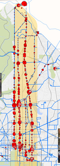
What do you get when you plot onto a single map every known light rail, streetcar, and BRT plan in the DC region? One heck of a huge transit network, is what.
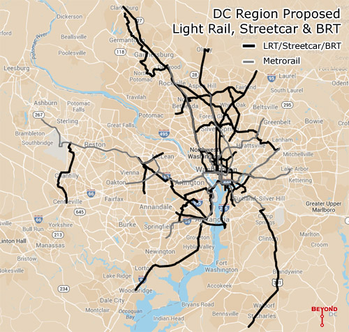 Every planned light rail, streetcar, and BRT line in the DC region. Click the map to open a zoom-able interactive version. Basemap from Google. This map combines the DC streetcar and MoveDC bus lane plan with the Arlington streetcar plan, the Alexandria transitway plan, Montgomery’s BRT plan, and Fairfax’s transit network plan, plus the Purple Line, the Corridor Cities Transitway, the Long Bridge study, the Wilson Bridge transit corridor, and finally the Southern Maryland transit corridor. Add the route mileage from all of them up and you get 267 miles of proposed awesomeness, not including the Silver Line or other possible Metrorail expansions. To be sure, it will be decades before all of this is open to passengers, if ever. The H Street Streetcar will be the first to open this year, god willing, with others like the Purple Line and Columbia Pike Streetcar hopefully coming before the end of the decade. But many of these are barely glimpses in planners’ eyes, vague lines on maps, years or decades away from even serious engineering, much less actual operation. For example, Maryland planners have been talking about light rail extending south into Charles County since at least the late 1990s, but it’s no higher than 4th down on the state’s priority list for new transit, after the Purple Line, Corridor Cities Transitway, and Baltimore Red Line. Never mind how Montgomery’s expansive BRT network fits in. Meanwhile in Virginia, the Gallows Road route seems to be a brand new idea. There’s yet to be even a feasibility study for it. Even if governments in the DC region spend the next few decades building this network, there are sure to be changes between now and the day it’s all in place. Metro’s original planners didn’t know Tysons would become the behemoth it is, and contemporary planners can’t predict the future with 100% accuracy either. Last year the Coalition for Smarter Growth published a report documenting every known route at that time, and already a lot has changed. More is sure to change over time. Holes in the network With a handful of exceptions these plans mostly come from individual jurisdictions. DC plans its streetcars, Montgomery County plans its BRT, and so on. That kind of bottom-up planning is a great way to make sure land use and transit work together, but the downside is insular plans that leave gaps in the overall network. Ideally there ought to be at least one connection between Fairfax and Montgomery, and Prince George’s ought to be as dense with lines as its neighbors. But still, 267 miles is an awfully impressive network. Now let’s build it. Average Rating: 4.6 out of 5 based on 220 user reviews.
May 6th, 2014 | Permalink
 Average Rating: 4.8 out of 5 based on 261 user reviews.
April 23rd, 2014 | Permalink
Not to be outdone by its neighbors’ aggressive plans for rail and BRT networks, Fairfax County has an impressive transit plan of its own.
Fairfax County’s proposed high quality transit network. Image from Fairfax. DC has its streetcar and moveDC plans, Arlington and Alexandria have streetcars and BRT, and Montgomery has its expansive BRT network, plus of course the Purple Line. Now Fairfax has a major countrywide transit plan too, called the High Quality Transit Network. Fairfax’s top priorities are to finish the Silver Line and the Bailey’s Crossroads portion of the Columbia Pike streetcar, but that’s not the end of their plans. County planners are also looking at several other corridors, including Route 1, Route 7 (both east and west of Tysons), I-66, Route 28, and Gallows Road/Dolly Madison Boulevard. Both rail and BRT are possibilities for all those corridors. Some may end up light rail or streetcar, others bus. Route 1 and I-66 could even include Metrorail extensions. In addition to all that, Fairfax County Parkway is slated for HOT lanes, which could make express buses a more practical option there. As the DC region continues to grow, and demand for walkable, transit-accessible communities continues to increase, these types of plans are crucial. If our major arterial highways are going to become the mixed-use main streets of tomorrow, transit on them must significantly improve. Fairfax is undeniably still spending a lot on bigger highways. Planners’ inability to calm traffic on Routes 7 and 123 through Tysons, for example, indicates roads are still priority number one. But it takes a plan to change, and this is a strong step forward. So good on Fairfax for joining the club. Average Rating: 4.4 out of 5 based on 277 user reviews.
April 22nd, 2014 | Permalink
Often when a new city proposes its first rail line, opponents who don’t like spending money on transit call for BRT instead. So it’s tempting to think cities might have an easier time implementing new transit lines if they simply planned BRT from the start. Unfortunately, BRT often faces the exact same opposition.
Nashville is the latest city to face strong opposition to its first BRT project, called the Amp. The Tennessee state legislature recently passed a bill blocking the line. The debate mirrors one going on a few hundred miles north, in Cincinnati. There, opponents tried to kill that city’s first streetcar line. The state government even tried to block it. Both Nashville and Cincinnati are among America’s most car-dependent and least transit-accessible large cities. Nashville’s entire regional transit agency only carries about 31, 000 passengers per day. Cincinnati’s carries about 58, 000. For comparison, Montgomery County’s Ride-On bus carries 87, 000, never mind WMATA. In places like Nashville and Cincinnati, authorities have ignored transit for so long that any attempt to take it seriously is inherently controversial, regardless of the mode. Arguments may fixate on rails, dedicated lanes, or overhead wires, but for at least some opponents those issues seem to be simply vehicles for larger ideological opposition. That may sometimes be true even in places with stronger transit cultures. Arlington’s streetcar and Montgomery’s BRT network are both controversial themselves. Both have plenty of detractors who say the plans are unaffordable or would get in the way of cars. Ultimately there are many reasons a city hoping to improve transit might choose BRT or rail. The two modes are both useful, and smart cities use them both based on the specific needs of the location. But either way, expect similar tropes from opposition. It’s inescapable. Average Rating: 4.4 out of 5 based on 177 user reviews.
April 9th, 2014 | Permalink
Every circle on this map is one bus stop. The larger the circle, the more riders get on or off at that stop. The map shows where riders are going on WMATA’s busy 16th Street, 14th Street, and Georgia Avenue lines, plus a couple of smaller routes in the same part of town. It’s a fascinating look at transit ridership patterns in DC’s densest corridor. And it correlates strongly with land use. Georgia Avenue is a mixed-use commercial main street for its entire length. Thus, riders are relatively evenly distributed north-to-south. 16th Street, on the other hand, is lined with lower density residential neighborhoods north of Piney Branch, but is denser than Georgia Avenue south of there. It’s not surprising then that 16th Street’s riders are clustered more heavily to the south. 14th Street looks like a hybrid between the two, with big ridership peaks south of Piney Branch but also more riders further north of Columbia Heights. 14th Street also has what appears to be the biggest single cluster, Columbia Heights itself. DDOT produced this map as part of its North-South Corridor streetcar planning. It’s easy to see why DDOT’s streetcar plans are focusing on 14th Street to the south and Georgia Avenue to the north. Likewise, this illustrates how a 16th Street bus lane south of Piney Branch could be particularly useful. Average Rating: 4.5 out of 5 based on 162 user reviews.
April 7th, 2014 | Permalink
I’m on vacation in Europe until the 24th. Each weekday until my return there will be a brief post about some feature of the city I’m visiting that day. My destination today, Amsterdam, is simultaneously one of the world’s greatest cycling cities and one of its greatest streetcar cities. It utterly destroys the notion that bikes & trams can’t coexist well. The real enemy to both is streets designed primarily for cars. That said, Amsterdam does a better job of separating both its bike and tram traffic from cars and from each other than any American city. That’s part of its success.
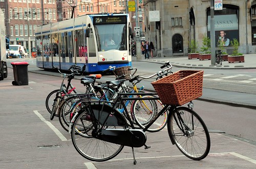 Amsterdam tram & bikes. Photo by faungg via flickr. Average Rating: 4.8 out of 5 based on 244 user reviews.
March 21st, 2014 | Permalink
Should potential future streetcars on Georgia Avenue have dedicated lanes? DDOT is hosting a series of public meetings this month to help plan that route. The meetings will be a good opportunity to voice support for dedicating street space to transit.
 The North-South Corridor, including 16th Street, 14th Street, and Georgia Avenue. Image from DDOT. DDOT’s North-South Corridor will run from somewhere near the baseball stadium north to either Takoma or Silver Spring, right through the heart of Mid City DC. Planners are still working on the exact route, but the line will probably run on some combination of Georgia Avenue and 14th Street. It could also be a bus or a streetcar. One big question is whether it will have any dedicated lanes. If you think it should, it’s important to attend one of the meetings and communicate that to DDOT. The meetings are:
There are many benefits to streetcars regardless of whether they have dedicated lanes or not. But giving them lanes absolutely increases their usefulness, especially in a corridor with such high transit demand. As part of any good corridor planning, it’s important to figure out where dedicating space makes the most sense. It’s also a good time to advocate for terminating the line at Silver Spring, where there are more potential riders than at Takoma. This is exactly the time and place for transit activists to show up. Average Rating: 4.6 out of 5 based on 236 user reviews.
February 5th, 2014 | Permalink
|
Media Tweets by @beyonddc
Follow @beyonddc
Site
Partners
|
|||||||||||||||||||||||||||||||
|