|
Special Features


Image Libraries


|
|
Blog
Now that’s we’ve had a big snow in DC, send us pictures of sneckdowns you spot in the wild. You can tweet them with hashtag #dcsneckdown, or email them to us at
sneckdown@beyonddc.com. On Monday, Greater Greater Washington and BeyondDC will publish the best ones.

Sneckdown today in Southeast DC. Photo by Ralph Garboushian.
Sneckdowns are where snow formations show the street spaces cars don’t use.
GGW reader Ralph Garboushian sent us this one already. He describes it:
“Shoveling and plowing patterns in front of my house show how the intersection of Potomac Avenue, E Street & 18th Street SE could be made safer for both pedestrians and motorists. The current design is a disaster – I have seen several accidents at this intersection, including one that sent a car nearly into my front yard and another that took out a historic call box and nearly knocked down a utility pole. In addition, this intersection is right in front of Congressional Cemetery and on the way to the Metro and sees heavy pedestrian traffic.
The intersection’s poor design combined with motorists speeding down Potomac create a hostile and dangerous atmosphere for pedestrians. This intersection desperately needs traffic calming and these plow/shovel patterns illustrate how it could be done.”
We look forward to seeing more!
 Cross-posted at Greater Greater Washington. Cross-posted at Greater Greater Washington.
Average Rating: 5 out of 5 based on 189 user reviews.
February 13th, 2014 | Permalink
Tags: environment, roads/cars, transportation, urbandesign

Am I crazy to actually like big highway rest stops?
Maryland’s newest one is scheduled to open along I-95 next week, following a complete reconstruction. And somehow, despite the fact that it’s merely a collection of fast food, dirty restrooms, and convenience marts, I think there will be just a touch of romance to the place.

The newly rebuilt Maryland House rest stop. Photo by MDTA.
Something about all waystations appeals to me. I know they’re mundane and often uncomfortable places, but all of them, from airports to train depots to I-95 travel plazas, somehow tickle my sense of fantasy.
I think it’s because waystations are the gathering places of travel, where humanity comes together and rests before setting off on adventure. Rest stops may not be exotic themselves, but they’re where exotic stories begin. Somehow, with hundreds of traveling partners bustling around me, being in a waystation makes travel feel like a quest.
Or maybe I’ve just got an overactive imagination. Does anyone else feel this way?
Cross-posted at Greater Greater Washington.
Average Rating: 4.4 out of 5 based on 173 user reviews.
January 16th, 2014 | Permalink
Tags: in general, question, roads/cars, transportation
Every time it snows, vast sections of city streets remain covered by snow long after plows and moving cars have cleared the travel lanes. These leftover spaces are called “sneckdowns, ” and they show where sidewalks or medians could replace roads without any loss to car drivers.
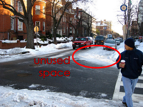
A DC sneckdown from the 2009 snow storm. Original photo by Rudi Riet on flickr.
The term sneckdown is a portmanteau of “snow” and “neckdown, ” the latter being another term for sidewalk curb extensions. So it literally means a sidewalk extension created by snow.
Following the recent snow storm in New York, Streetsblog put out a call for photos of sneckdowns in the wild. They received plenty of responses.
Next time it snows here, be on the lookout.
Cross-posted at Greater Greater Washington.
Average Rating: 4.5 out of 5 based on 295 user reviews.
January 8th, 2014 | Permalink
Tags: environment, roads/cars, transportation, urbandesign
Green-painted bike lanes make cycling safer, by reminding car drivers to watch out for cyclists when driving across bike lanes. That’s a great benefit, and it works, but it’s not the main reason so many cyclists get so excited over a little bit of color.
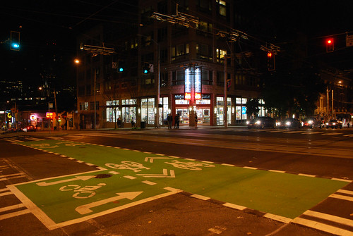
Green paint on Seattle’s Broadway cycletrack.
The real reason Cyclists love green-painted bike lanes so much is simple: They send the clearest-possible message that roads are not only for cars.
Despite a century of sharing roads, and despite the fact that people walked and biked in streets long before cars came along, there’s a strong mentality among entitled drivers that roads are for cars. A 5 second google search turns up plenty of examples.
Green-painted bike lanes accomplish what a white stripe next to the parking lane cannot. They proclaim loudly and clearly that streets are not merely sewers for car traffic, but fully multimodal public spaces. They send the message that drivers are welcome to use roads just like everyone else, but must not expect to have roads completely to themselves.
These painted lanes are public relations features as much as they are safety features, at least as far as cyclists are concerned.
Cross-posted at Greater Greater Washington.
Average Rating: 4.7 out of 5 based on 162 user reviews.
December 9th, 2013 | Permalink
Tags: bike, roads/cars, transportation
Despite years of planning to transform Tysons Corner from a car-oriented edge city into a walkable downtown, some Virginia residents are surprised to learn that Tysons’ 4 Metro stations will not be surrounded by parking lots.
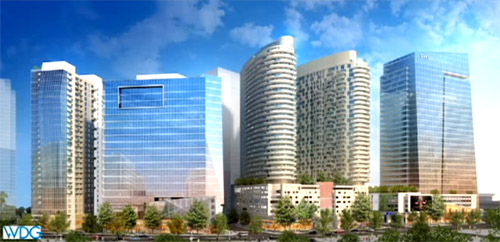
Development planned at the Spring Hill Metro station. Image from Fairfax County.
The confusion seems to stem from a mix-up about what Metro stations in Tysons Corner are supposed to accomplish. Are they places for DC-bound commuters to board, or are they the destination stations for people working in Tysons? There will surely be some of both, but most users will be the latter, and they’re who the line must be designed to best serve.
If stations are surrounded by parking that will reduce the number of buildings within walking distance of Metro. Not only that, it would also make the walk less interesting and more dangerous, since walking through a busy parking lot is hardly a pleasant experience. That in turn would reduce the number of people who could use Metro to commute to Tysons. That would undermine the entire project.
The main purpose of the Silver Line project is to transform Tysons Corner. Tysons is a behemoth, with about the same amount of office space as downtown Baltimore. It can’t grow or continue to prosper as a car-oriented place. Nor would it make sense to invest almost $7 billion in a new Metrorail line if it were not going to support a more urban Tysons, or serve easy commuting into Tysons.
Consider other walkable downtown areas, like downtown DC or Rosslyn. Would it make sense if Gallery Place Metro station were surrounded by parking instead of buildings? Of course it would not. Tysons will one day be the same. It may not look like that yet, but it never will if its best land is used for parking lots.
Yes, it’s true there should be enough parking along the Dulles Corridor for commuters into DC to use the system. That’s why there are large parking lots at the Wiehle Avenue and West Falls Church stations. There’s no need for drivers to enter congested Tysons Corner to find parking, when more highway-oriented stations exist specifically for that purpose.
Alternatively, those few drivers who do want to park in Tysons will surely be able to do the same thing they do in Ballston, DC, Bethesda, or anywhere else: Pay to park in a nearby garage, and walk a couple of blocks. As more new buildings are built near Metro stations, there will be more available private garages to pick from.
There may be some small number of people currently living in Tysons who refuse to walk to stations, and will have to drive out of Tysons to find parking. That’s unfortunate, but accommodating them with parking lots at urban stations would make those stations less convenient for the larger number of walkers, and future walkers.
Temporary parking isn’t a panacea
Some suggest that since it may be a few years before all the land near Metro stations is developed, it could be used as interim parking on a temporary basis. In fact, that’s exactly the plan at the McLean station, where 700 parking spaces will be available at first.
That could be a workable idea in a few places, especially at McLean, which is the easternmost of Tysons’ 4 stations. But it’s less practical than some may assume, because most of the land surrounding these stations isn’t currently empty.
For example, Greensboro station is surrounded by strip malls. They will eventually be redeveloped into high-rises, but in the meantime the property owners make more money with retail there than they would with just parking.
In places where Fairfax County or WMATA can strike deals with landowners to let Metro riders use existing parking lots, that’s fine. But it does not make sense to tear down functional money-making buildings and replace them with temporary parking lots. Especially when there are better parking options elsewhere for drivers hoping to park and ride.
The bottom line is that Tysons Metro stations were planned correctly. Some interim measures are OK if they’re practical, but surrounding Tysons Metro stations with parking would undermine the entire reason for running the Silver Line through Tysons in the first place.
Cross-posted at Greater Greater Washington.
Average Rating: 4.7 out of 5 based on 234 user reviews.
December 3rd, 2013 | Permalink
Tags: metrorail, roads/cars, transportation, urbandesign
This map shows US counties, colored according to the average number of cars owned per household.
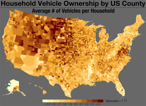
Several broad trends are visible, most of them not surprising to anyone. But it is surprising that so many counties in Virginia stand out, with higher rates than otherwise comparable counties in nearby eastern states. What’s different about the Old Dominion, versus West Virginia or North Carolina?
The map is from Tumblr blog Vizual Statistix, which has a lot of interesting data visualizations. It’s worth a read.
Cross-posted at Greater Greater Washington.
Average Rating: 4.9 out of 5 based on 204 user reviews.
December 2nd, 2013 | Permalink
Tags: demographics, maps, roads/cars, transportation
For streetcars to move through traffic, rail tracks have to be free of parked cars. To keep them that way, the rules of the road must be crystal clear for drivers.
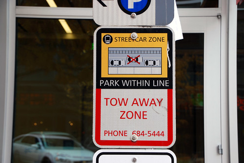
Streetcar parking zone sign, Seattle.
Last week DDOT used a truck for a test-run of the H Street streetcar route, and because of illegally parked cars, the going was slow. But other cities with similar streetcar layouts, like Seattle and Portland, have had a lot of success keeping their lanes clear. How do they do it?
With constant and clear communication to drivers, like the sign pictured here, and with strong enforcement.
Any time you take pavement away from cars, there’s a learning curve. Drivers accustomed to doing as they please have to change behavior. That’s to be expected, and it doesn’t happen on the first day you run your first test truck. But most drivers do fall in line, once they understand what’s changed. That’s how streetcars have worked in other cities.
And if all else fails, ticketing cameras mounted on streetcars, like in San Francisco, would solve any remaining problem in a hurry.
Cross-posted at Greater Greater Washington.
Average Rating: 4.8 out of 5 based on 209 user reviews.
November 25th, 2013 | Permalink
Tags: roads/cars, streetcar, transportation
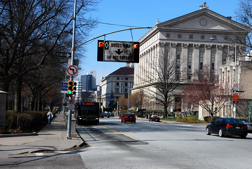
Every day 33 bus routes converge on H and I Streets in downtown DC, making it the busiest bus corridor in the DC region. According to a WMATA report, a contraflow bus lane on H Street would dramatically improve travel times for both transit riders and car drivers.
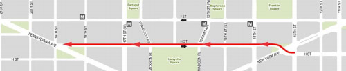
Potential H Street contraflow bus lane. Image from WMATA.
At peak times, one bus per minute travels along H or I. At off-peak, it’s a bus every two minutes. Today, all those buses mix with car traffic on both H and I Streets, which slows them down. Meanwhile, all those buses make several stops to pick up and unload passengers, which slows down car traffic trying to use the same lane.
Moving all the buses to H Street, which is less congested, and giving buses in the westbound direction a separated lane, would speed up both modes.
Since H Street is one-way going east, westbound buses would need a contraflow lane. There are no contraflow bus lanes in the DC region today, but they do work well in other cities around the US.
Contraflow bus lane in Pittsburgh.
In its report, WMATA also studied bus lanes on both H and I Streets, as well as a traffic management alternative that wouldn’t provide bus lanes, but would optimize traffic signals for buses. All the alternatives improved bus travel, and all of them either improved or maintained current car travel. But the H Street contraflow alternate provided the best combination of benefits, for relatively low cost.
Ultimately DC owns these streets, so the decision to actually implement bus lanes on them rests with the District, not WMATA. But Metro’s report could push DDOT to begin its own study process.
Seems like a good idea.
Cross-posted at Greater Greater Washington.
Average Rating: 4.9 out of 5 based on 215 user reviews.
November 14th, 2013 | Permalink
Tags: bus, roads/cars, transportation
One company is taking the term “land yacht” to new more literal heights (or would it be lows?). For $3 million dollars to buy, and probably about the same in annual gas bills, you can own this: The Marchi Mobile eleMMent Palazzo Land Yacht.
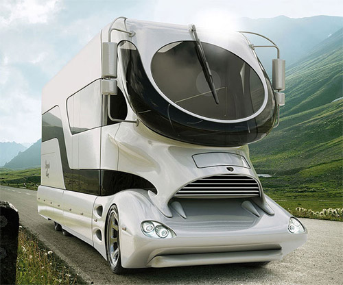
Image from Marchi Mobile.
Average Rating: 5 out of 5 based on 281 user reviews.
November 8th, 2013 | Permalink
Tags: roads/cars, transportation
Lots of bridges around the world can be raised to let ships pass under, but not many look like this.
It’s the Slauerhoffbrug, of Leeuwarden, Netherlands, and it’s quite a sight. Here’s a video of it in action.
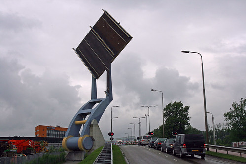
Slauerhoffbrug, aka the flying bridge of Leeuwarden, Netherlands.
Photo by Bert Kaufmann on flickr.
Average Rating: 4.5 out of 5 based on 277 user reviews.
October 18th, 2013 | Permalink
Tags: boat, fun, roads/cars, transportation
|
Media


Site
About BeyondDC
Archive 2003-06
Contact
Category Tags:
Partners
|


