|
Special Features


Image Libraries


|
|
Blog
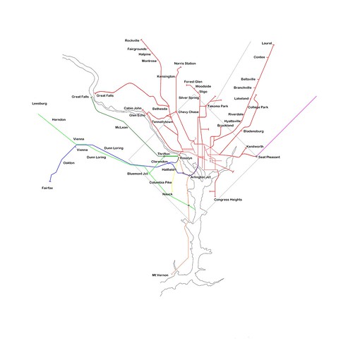
Tysons Corner has more office space than downtown Baltimore, Richmond, and Norfolk put together. It should be the center its own large transit network. The Silver Line and express buses on the Beltway HOT lanes are good first steps, but in the long run Tysons is going to need more routes, connecting it to more places.
In the long run, Tysons needs something more like this:
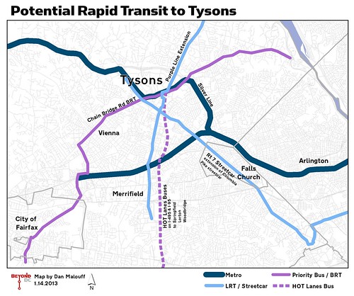
In recent years, planners in Virginia have begun to seriously consider a Tysons-centric rapid transit network. It doesn’t have a name, and isn’t officially separate from any of the other transportation planning going on in the region, but it shows up on long range regional plans like SuperNoVa and TransAction.
In addition to the Silver Line, HOT Lanes Buses, and Tysons’ internal circulation network, officials are beginning to study light rail connections to Maryland, Falls Church, and Merrifield, and BRT on the Chain Bridge Road corridor.
It will be years before any of these additional routes are implemented, and they could look very different from this map once they finally are. Details don’t exist yet, because at this point these are little more than ideas.
But to work as the urban place Fairfax County officials hope Tysons will become, this is the sort of regional infrastructure it’s going to need.
 Cross-posted at Greater Greater Washington. Cross-posted at Greater Greater Washington.
Average Rating: 4.7 out of 5 based on 150 user reviews.
January 14th, 2013 | Permalink
Tags: BRT, bus, lightrail, metrorail, streetcar, transportation

|
Development like this is impossible with parking minimums. |
Parking minimums don’t just affect parking. They have a huge impact on the overall scale of buildings. Developers that have to include off-street parking have to build bigger and bulkier buildings in order to make their projects work.
It’s true that parking minimums encourage more driving, but the impacts on urban design and architecture may be even more important. The problem is that parking lots take up a lot of space, which makes development of small properties harder.
As a result, developers faced with parking minimums always try to build on the largest piece of land possible.
So if you like old style main streets, parking minimums are the enemy.
In places without parking minimums it’s more practical to build charming narrow buildings, like those that populate historic main streets all over the country. But where parking minimums exist, developers need larger properties big enough to fit parking lots.
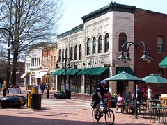
Take a look at the buildings in these two pictures. They’re ostensibly similar. Both are 3 stories with a 4th floor attic. Both are primarily brick. Both have shops on the ground level, with other uses above. The key difference is that the left picture is a single building built by a single developer, while the right picture shows a block of narrow buildings on individual properties.
University Drive, Fairfax.
Image from Google. |
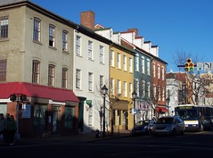
King Street, Alexandria.
Image from BeyondDC. |
Which one do you like better? Most people prefer the buildings in the right picture, because they’re built at a more human scale. Even though the building on the left is about the same height, it seems like a hulking monster because it’s so long.
One of the big reasons it’s so long: Parking.
Parking lots take up so much space and push developers towards larger buildings because parking lots aren’t just parking spaces. They’re really entire streets. Since you can’t get to a parking space unless it’s got a driving lane next to it, every row of parking spaces has to have an entire street built in front of it.
Unfortunately, it’s geometrically impossible to fit a two-way driving lane and a bunch of parking spaces behind a main street style 25-foot-wide building. Thus, developers need bigger properties, and old style main streets are essentially illegal to build.
Parking garages and underground parking are even worse. They don’t just need driving lanes, they need ramps too, not to mention elevators, stairs, and air ducts. So anyone who wants to build something that requires structured parking needs even more land.
This is one of the biggest reasons why contemporary development happens at the scale that it does. There are other reasons too, but this is a key one. In order to meet parking requirements imposed by city governments, developers have to scale-up their buildings to fit parking lots. In turn, those 19th Century main streets that everyone loves so much are effectively impractical and illegal to build.
Average Rating: 4.9 out of 5 based on 161 user reviews.
January 11th, 2013 | Permalink
Tags: architecture, roads/cars, transportation, urbandesign
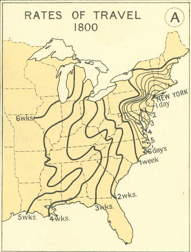
Railroads and the Making of Modern America has a really interesting series of maps up, illustrating how long it took to travel across the country at various times in American history.
In 1800 it took 4 days to get from DC to New York. By 1830 it took only 2, and by the 1850s it could be done in less than 1.
Here’s the first map, but take a look at them all.
Average Rating: 4.6 out of 5 based on 224 user reviews.
January 10th, 2013 | Permalink
Tags: history, intercity, transportation
This map claims to show every local electric railway line that operated in the region between 1890 and 1962, regardless of who operated it or when it ran. That makes this much more comprehensive than DC Transit maps that only show one company’s lines, and only from a single year.
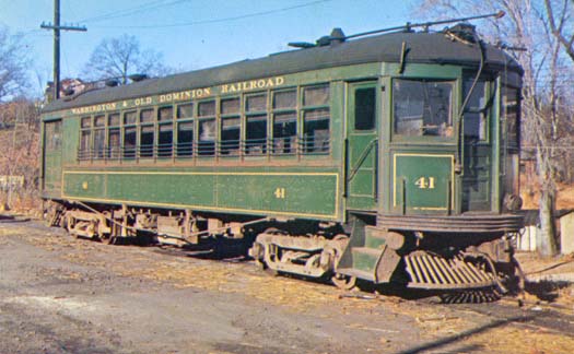
Some of the longer lines on this map are “interurbans, ” which were trolley vehicles that functioned more like commuter rail than central city streetcars, stopping less frequently and running on longer headways. Today we’d probably call them light rail. They’re on the map because no matter their route characteristics, they were basically electric trolleys. That includes Virginia’s well-known W&OD, which isn’t usually called a trolley line today.
The map first appeared on wikipedia and was created by the anonymous user “SDC”.
Average Rating: 4.6 out of 5 based on 254 user reviews.
January 8th, 2013 | Permalink
Tags: commuterrail, history, lightrail, streetcar, transportation
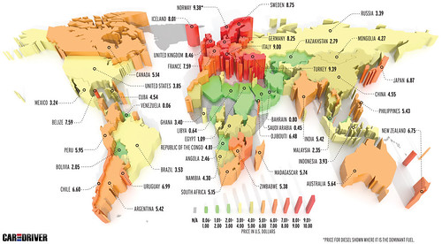
According to an international survey, the price of gasoline in the United States is still lower than in most of the rest of the world’s developed countries. The survey, by Car and Driver magazine, included this handy map showing the average price of 1 gallon of gas in US dollars for most of the world:
Average Rating: 4.6 out of 5 based on 191 user reviews.
January 7th, 2013 | Permalink
Tags: economy, energy, roads/cars, transportation
|
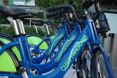
Bike Chattanooga, the largest new US bikesharing system in the US in 2012. Image by Elly Blue on flickr. |
2012 turned out to be an unexpectedly quiet year for bikesharing. New York and Chicago were expected to launch systems larger than Capital Bikeshare, but delays have pushed them to 2013. Washington, Minneapolis, and others did expand, but it wasn’t the banner year that was anticipated.
As a result, for the third straight year Capital Bikeshare is the largest bikesharing network in America.
At the end of 2011 there were 18 bikesharing systems in the US, with a total of 559 stations. Now there are 27 systems, with 834 stations.
- 10 new systems opened, but none of them are very large. The biggest is Chattanooga, TN, with 30 stations.
- One system closed. In 2011 Chicago operated a small 7 station pilot program that has since shut down. They plan to open a new and much larger system in 2013.
- Of the 18 networks open in 2011, 9 expanded in 2012. The most significant expansions were in Washington, Minneapolis, and Boston. Boston’s expansion was enough to pass Miami Beach.
Here’s the complete list of bikesharing networks in the US, ranked by number of stations. New systems in 2012 are in bold:
| Rank |
City |
2011 Stations |
2012 Stations |
| 1 |
Washington |
140 |
191 |
| 2 |
Minneapolis |
115 |
145 |
| 3 |
Boston |
61 |
105 |
| 4 |
Miami Beach |
70 |
84 |
| 5 |
Denver |
52 |
53 |
| 6(t) |
San Antonio |
20 |
30 |
| 6(t) |
Chattanooga |
0 |
30 |
| 8 |
Ft Lauderdale |
20 |
25 |
| 9 |
Madison |
27 |
24 |
| 10 |
Boulder |
15 |
22 |
| 11(t) |
Charlotte |
0 |
20 |
| 11(t) |
Nashville |
0 |
20 |
| 13(t) |
Long Beach, NY |
0 |
12 |
| 13(t) |
Kansas City |
0 |
12 |
| 15(t) |
WSU – Pullman |
8 |
9 |
| 15(t) |
Georgia Tech – Atlanta |
0 |
9 |
| 17 |
Oklahoma City |
0 |
7 |
| 18 |
Greenville, SC |
0 |
6 |
| 19 |
Omaha |
5 |
5 |
| 20(t) |
Cal – Irvine |
4 |
4 |
| 20(t) |
Des Moines |
4 |
4 |
| 20(t) |
Tulsa |
4 |
4 |
| 20(t) |
GMU – Fairfax |
0 |
4 |
| 24(t) |
Louisville |
3 |
3 |
| 24(t) |
Houston |
0 |
3 |
| 26(t) |
Kailua, HI |
2 |
2 |
| 26(t) |
Spartanburg, SC |
2 |
2 |
| NA |
Chicago |
7 |
0 |
Notes: For the purposes of this list, systems covering multiple jurisdictions are counted together if they are close enough for significant cross-border ridership, and separately if they are too far apart. Thus, Washington/Arlington/Alexandria and Miami Beach/Surfside are counted together, but Denver/Boulder are counted separately.
Average Rating: 4.7 out of 5 based on 228 user reviews.
January 4th, 2013 | Permalink
Tags: bike, transportation
|
Media


Site
About BeyondDC
Archive 2003-06
Contact
Category Tags:
Partners
|


