|
Special Features


Image Libraries


|
|
Blog
The FBI is considering moving its headquarters from downtown Washington to either Greenbelt, Landover, or Springfield. If they pick Greenbelt, here’s what the development will look like:
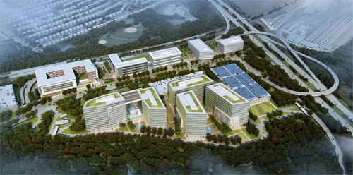
Greenbelt development rendering. Image from Renard Development/Gensler.
Under this plan, a new mixed-use transit-oriented development would replace the parking lot at the Greenbelt Metro station. The FBI would occupy the five buildings on the bottom of the rendering, with other offices, apartments, retail, and a hotel taking up the rest.
Greenbelt Metro station is located in the upper left side the rendering, immediately behind the building that looks like a “6” digit tipped on its side. To the right of that building, a central plaza would be the area’s main public space, and one of Prince George’s most urban spots.
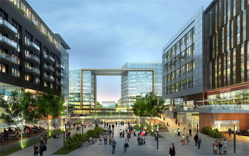
Proposed view from the Greenbelt Metro station. Image from Renard Development/Gensler.
The Metro’s existing entrance is immediately behind the “6” building. It would be nice if a new Metro entrance would line up directly with the plaza, though it looks more like a short walkway behind the building will connect the station to the plaza.
Since Greenbelt is an end-of-line station, the development replaces all the Metro commuter parking. But instead of surface parking lots, it would go in a new parking garage shown on the far left of the overview rendering, connected to the station with a wide, suburban-style street.
Clustering mixed-use development next to the Metro station and putting the FBI buildings and park-and-rides across the street makes a lot of sense. That layout provides a parking lot for commuters and gives the FBI the space it wants for a buffer without sacrificing the walkability of the entire neighborhood.
Meanwhile, FBI workers who don’t commute via Metro would use the parking garage on the far right, next to the Beltway.
Overall, this looks like a decent plan. There are a lot of less than ideal trade-offs, but given the demands of an end-line station and the FBI, it’s not terrible.
 Cross-posted at Greater Greater Washington. Cross-posted at Greater Greater Washington.
Average Rating: 4.5 out of 5 based on 296 user reviews.
July 31st, 2014 | Permalink
Tags: development, urbandesign

When Phase II of the Silver Line eventually opens, it will carry passengers to two stations in Loudoun County. But that’s still a few years away. In the meantime, Loudoun is already sprucing up transit with more buses and improved park-and-rides.
On June 30, the Virginia Department of Transportation opened this snazzy new canopy at the Dulles North Transit Center, a bus depot near the future Route 606 Metro station.
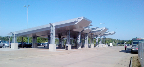
Photo by VDOT.
Average Rating: 4.5 out of 5 based on 187 user reviews.
July 29th, 2014 | Permalink
Tags: bus, transportation
Metro’s new Silver Line is officially open and carrying passengers. Enjoy this photo tour of the new line and opening day festivities.
> Continue reading at Greater Greater Washington
Average Rating: 5 out of 5 based on 299 user reviews.
July 28th, 2014 | Permalink
Tags: architecture, development, events, galleries, metrorail, transportation
Mid summer is prime time for big transit openings, and this weekend is a doozy. Three big projects around the US are opening today or tomorrow.
Silver Line. Photo by Fairfax County. |
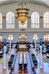
Denver Union Station. Photo by Ryan Dravitz for DenverInfill.com. |
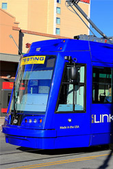
Tucson streetcar. Photo by Bill Morrow on Flickr. |
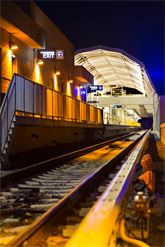
By now, probably everyone in the DC region knows the Silver Line opens tomorrow, Saturday the 26th.
The same day, Denver’s gloriously updated Union Station opens its final component, the renovated historic main hall. Other portions of Denver’s Union Station opened in May.
But Tucson beats both DC and Denver by one day. Their Sun Link streetcar opens today, at 9:00 am Mountain Time (11:00 am Eastern Time). Sun Link uses the same streetcar vehicles as DC’s H Street line, built by the same company, as part of the same production run.
Speaking of the H Street streetcar, although it’s not opening this weekend, it is nonetheless making visible progress. The final streetcar vehicle has finally arrived in DC from the factory. Four streetcars are now on H Street for testing, plying the route on their own power. And pylon signs are starting to appear at streetcar stations.
All these projects have been a long, difficult road. It’s great to see them starting to pay off.
Average Rating: 5 out of 5 based on 150 user reviews.
July 25th, 2014 | Permalink
Tags: events, intercity, metrorail, streetcar, transportation
Most people consider the 555 foot tall Washington Monument to be DC’s tallest tower. It’s certainly the city’s most iconic. But it’s not the tallest. That distinction belongs to the 761 foot tall Hughes Tower.

Hughes Tower. Photo by thebrightwoodian on Flickr.
Hughes Tower is in Brightwood, near the corner of Georgia Avenue and Peabody Street NW. It’s primarily a radio transmission tower, broadcasting signals for the Metropolitan Police Department.
The tower is owned by the District of Columbia, and was built in 1989.
Although the tower vastly overshoots DC’s usual height limit, transmission towers are one of several exempted categories of structures. Thus, a 761-foot tower doesn’t necessarily violate federal law, though DC’s zoning code imposes other limits that prevent anyone from just building such a tower. The National Capital Planning Commission also wasn’t happy about this one.
Cross-posted at Greater Greater Washington.
Average Rating: 4.8 out of 5 based on 246 user reviews.
July 24th, 2014 | Permalink
Tags: architecture
DC has had a smattering of bike lanes since at least 1980, but the network only started to grow seriously starting in about 2002. This animation shows the growth of DC’s bike lane network, from 1980 through to 2012.
Animation from Betsy Emmons on MapStory.
From 1980 to 2001, literally nothing changed. Then in 2001, two short new bike lanes popped up. The next year there were 5 new ones. From then on, District workers added several new bike lanes each year, making a boom that’s still going on.
This animation ends in 2012, so it doesn’t include recent additions like the M Street cycletrack. But it’s still a fascinating look at how quickly things can change once officials decide to embrace an idea.
In a few years, a map showing the rise of protected bike lanes might start to look similar. That map would start in 2009 with DDOT’s installation of the original 15th Street cycletrack. It would expand slowly through this decade, then maybe (hopefully), it would boom as moveDC’s 70 mile cycletrack network becomes a reality.
Cross-posted at Greater Greater Washington.
Average Rating: 4.8 out of 5 based on 219 user reviews.
July 23rd, 2014 | Permalink
Tags: bike, maps, transportation
Can you barely wait until Saturday to ride the Silver Line? Get a sneek peek of the new line with this video from WMATA.
Video from WMATA. The video has no audio.
This shows the view from a Silver Line train as it travels from Ballston to Wiehle-Reston East.
Silver Line trains began running simulated service over the weekend. Trains carry passengers from Largo to East Falls Church under an Orange Line banner, then offload and continue on to Wiehle without any passengers.
Cross-posted at Greater Greater Washington.
Average Rating: 4.6 out of 5 based on 177 user reviews.
July 21st, 2014 | Permalink
Tags: metrorail, transportation
A curious thing appeared on a downtown DC sidewalk this week: Dedicated lanes for pedestrians talking on cellphones, with an express lane to the side for everyone else.
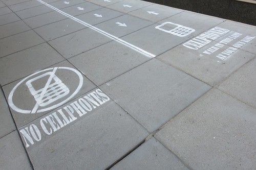
Photo by Rob Pegoraro on Flickr.
The lanes aren’t a half-baked experiment from DDOT. They’re actually a stunt from National Geographic.
National Geographic workers added the sidewalk lanes, with permission from DDOT, to film people’s reactions for an upcoming TV show about human behavior.
Film crews recorded pedestrians’ reactions for several hours yesterday. The most common reaction seemed to be curiosity, but according to Yahoo! Tech columnist Rob Pegoraro, the new lanes did inspire many people to move to one side or the other.
The sidewalk lanes are marked on the 1000 block of 18th Street NW, between K Street and L Street.
This might have drawn inspiration from a “tourist lane” New York-based group Improv Everywhere painted on a Manhattan sidewalk in 2010.
Cross-posted at Greater Greater Washington.
Average Rating: 4.6 out of 5 based on 185 user reviews.
July 18th, 2014 | Permalink
Tags: fun, pedestrians, social, transportation
Lengthening all Metrorail trains to 8 cars long would add as much capacity to the I-66 corridor as widening the highway by two to four lanes.
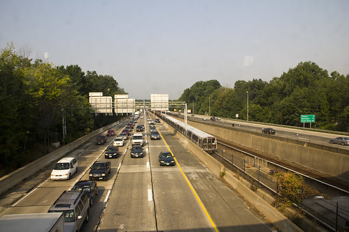
I-66. Photo from Bossi on Flickr.
If Metro lengthened all trains to 8 railcars, it would increase capacity on the Orange/Silver Line through Arlington by 4, 740 passengers per hour per direction. Comparatively, one new highway lane would be able to carry 2, 200 cars per hour.
Even assuming two passengers per car (likely higher than the real average), a new highway lane would only carry 4, 400 passengers per hour. Still fewer than 8-car Metro trains.
Then, to account for the reverse direction, double all calculations. Bidirectional Metrorail capacity would increase by 9, 480 passengers per hour, equivalent to 4.3 lanes full of single-occupant cars, or 2.15 lanes full of cars with two passengers each.
Eight-car trains would also be cheaper and carry passengers faster than equivalent new highway capacity, according to WMATA’s PlanItMetro blog.
Clearly it’s time to think longer, not wider.
Cross-posted at Greater Greater Washington.
Average Rating: 4.6 out of 5 based on 235 user reviews.
July 15th, 2014 | Permalink
Tags: metrorail, roads/cars, transportation
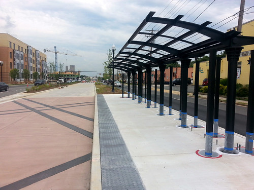
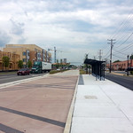
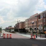
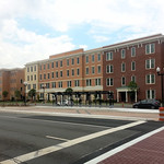
Construction on Alexandria’s Route 1 transitway is coming along, in anticipation of its August 24 opening. These pictures show the station at Route 1 and Custis Avenue.
While Alexandria’s transitway is just about ready, the second phase of the same project, in Arlington, is still a grassy strip. But preliminary construction work started earlier this year, and Arlington officials will host an official groundbreaking on Friday, July 18, at 9:00 am.
Cross-posted at Greater Greater Washington.
Average Rating: 5 out of 5 based on 157 user reviews.
July 14th, 2014 | Permalink
Tags: BRT, galleries, streetcar, transportation
|
Media


Site
About BeyondDC
Archive 2003-06
Contact
Category Tags:
Partners
|