|
Special Features


Image Libraries


|
|
Blog
|
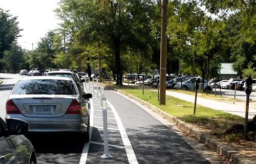
New York’s 67-dock station.
Photo from Google. |
Throughout 2014, DC and New York have jockeyed back and forth over which city’s bikeshare system has the most stations in the United States. But who has the biggest stations?
DC currently leads in the number of stations race, 335 to 324. But the number of stations only tells part of the story. New York’s stations are vastly bigger than DC’s, and by far the largest in the US.
New York’s biggest station, which is outside of Penn Station, has a whopping 67 docks. It’s almost 50% larger than the next city’s largest station.
Here’s the number of docks at the biggest station in America’s main big-city bikeshare systems:
 Cross-posted at Greater Greater Washington. Cross-posted at Greater Greater Washington.
Average Rating: 4.6 out of 5 based on 257 user reviews.
August 29th, 2014 | Permalink
Tags: bike, transportation

A father and son comfortably bike down a slow Arlington street. They approach the new Hayes Street cycletrack. The father asks “Want to take the special bike lane?” The son responds with an excited “Yeah!”
The father and son.
I overheard that interaction this past weekend, and had to stop and smile.
That one brief conversation sums up why protected bike lanes are so great: They make city streets safe, comfortable, and fun for even children to bicycle on. Not to mention older people, less-able people, and novice cyclists.
If Americans ever hope to make cycling for transportation a mainstream activity, cycling must feel comfortable for everyone. Getting bikes out of the path of speeding cars is a big part of that.
Cross-posted at Greater Greater Washington.
Average Rating: 4.5 out of 5 based on 290 user reviews.
August 27th, 2014 | Permalink
Tags: bike, transportation
The DC region’s first Bus Rapid Transit line opened this weekend. Metroway runs from Crystal City to Braddock Road, using a transitway along Route 1 in Alexandria.
> Continue reading at Greater Greater Washington
or
> See the full flickr set
Average Rating: 4.6 out of 5 based on 168 user reviews.
August 25th, 2014 | Permalink
Tags: BRT, bus, transportation
London is adding protected bike lanes to one of its traffic circles. Could the same design work in DC? Would we want it to?
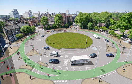
London traffic circle, with protected bike lanes in green. Image by London.
London city workers recently began rebuilding the Queen’s Circus traffic circle to include protected bike lanes. Since central DC has so many traffic circles, it’s worth considering whether the Queen’s Circus design could work here too.
DC’s big traffic circles are notoriously difficult places to bike. They have multiple lanes of intimidating and zig-zagging car traffic, and sidewalks too packed with pedestrians to be good bike paths. Most of the circles lack bike lanes, and those that have them (Columbus Circle and Thomas Circle) are still far from comfortable places to bike.
But the traffic circles are key destinations. People want to use them. Making the circles more bike friendly would be great for DC.
Would we want to do this?
This is sort of a good design. It’s better than nothing. But with so many crossings, it’s still pretty confusing what’s the bike lane and what’s for cars. It seems likely there will still be a lot of intimidating cross traffic.
In fact, the actual design doesn’t even have the green paint; I added that to make the rendering clearer.
The other big problem with the London example is that pedestrians are mostly absent. Unlike DC’s circles that typically have popular parks in the middle, this London circle is just a road. The central grassy section isn’t a useful park, and there are no pedestrian crossings into it. That obviously changes how the entire thing functions.
Look to the Dutch
Perhaps a better example might come from this traffic circle in Rotterdam, where in typically Dutch fashion the bike lanes are much more well protected.
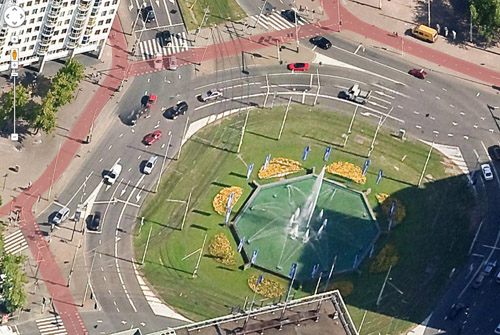
Rotterdam traffic circle, with protected bike lanes in red. Image by Google.
Rather than fight with cars, the Dutch put the bike lanes up on the sidewalk. That’s more ideal from a cyclist perspective, but it’s also much harder to accomplish.
The sidewalks around DC’s downtown circles are too narrow in many places to accommodate bike lanes. DDOT could theoretically rebuild the circles to have wider sidewalks and narrower roadways, but that would be controversial to say the least, not to mention a lot more expensive than striping a bike lane on the street.
The Dutch example is better, but the British example is more achievable.
Cross-posted at Greater Greater Washington.
Average Rating: 5 out of 5 based on 287 user reviews.
August 21st, 2014 | Permalink
Tags: bike, transportation
Arlington’s first significant protected bike lane quietly popped up last week in Pentagon City. It runs on South Hayes Street from 15th Street to Fern Street, next to Virginia Highlands Park.
South Hayes Street cycletrack. Photo by Darren Buck.
There are actually two cycletracks. There’s a grassy median in the middle of Hayes Street, so in order to serve bicyclists going both directions, each side of the street has its own one-way cycletrack next to the curb.
The cycletrack connects to the new green-painted bike lanes on Hayes Street further north, forming a spine for cycling through Pentagon City.
Technically speaking this is Arlington’s second cycletrack. The first one, in Rosslyn, is so short that it hardly counts. Hayes Street is the first significant one.
It’s great to see such high quality bike infrastructure appearing in more jurisdictions. Who will be next? Maybe Montgomery?
Cross-posted at Greater Greater Washington.
Average Rating: 4.9 out of 5 based on 160 user reviews.
August 19th, 2014 | Permalink
Tags: bike, transportation
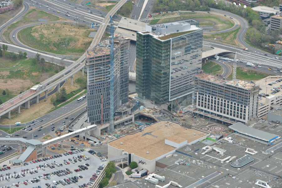
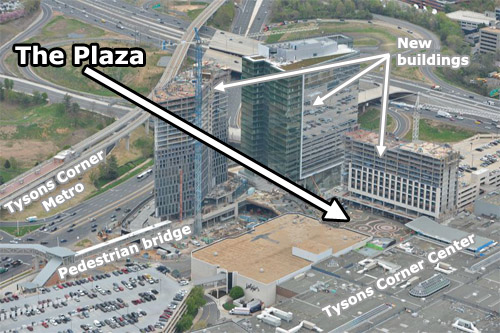
Metro’s Silver Line isn’t the only indication the transformation of Tysons Corner is clearly underway. Further undeniable evidence: The Plaza, a popular new urban-style open space at the front door to Tysons Corner Center mall.
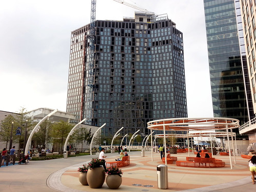
The Plaza (that’s its official name) is on the north side of the mall, near the pedestrian bridge from the Tysons Corner Metro station. Three new high-rises are under construction around the plaza, tightly enclosing the space like a genuine city square.
The Plaza and its surroundings. Original photo from Macerich.
The pedestrian bridge to the Metro station isn’t open yet, because the high-rise it connects is still under construction. But when all is said and done, The Plaza will become the main entry point to the mall from the Metro. In a very real sense it will become the center of this emerging urban neighborhood.
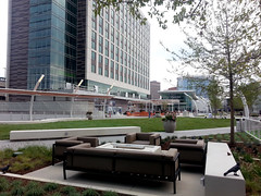
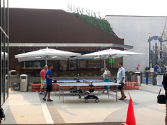
Befitting Tysons, The Plaza is a thoroughly contemporary update on the classic city square. There’s no marble statue in the middle, no grand fountain like in Dupont Circle. Instead, there are padded couches, small-scale artistic flourishes, and outdoor games.
 |
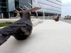 |
| Couches (left), and sculpted birds (right). |
 |
 |
| Ping pong (left) and corn hole (right). |
The first plaza-fronting retail, a Shake Shack, opened earlier this week. More is coming soon.
One crucial difference between The Plaza and a traditional city square is who owns it. This may masquerade as civic space, but it’s clearly private property. Security guards patrol the square, and you can bet homeless people aren’t welcome to sleep on benches.
But still, The Plaza is a big step forward for Tysons. It’s a genuine gathering place, and people are using it. Even without the Metro connection, plenty of other people were hanging out nearby when I visited last weekend. It’s not the kind of place that a mere 20th Century office park would support.
Cross-posted at Greater Greater Washington.
Average Rating: 4.4 out of 5 based on 162 user reviews.
August 14th, 2014 | Permalink
Tags: development, fun, parks, urbandesign
Pop quiz: Can you name the 5 Metro stations that have the highest number of households within a half-mile walk? Here’s a hint: More riders walk to those 5 stations each morning than to just about any others in the system.
It’s not a coincidence. According to WMATA’s PlanItMetro blog, “the more people can walk to transit, the more people do walk to transit — and data across Metrorail stations prove it.”
But there’s at least one surprise: 3 of the 5 stations with the most households nearby are in Maryland or Virginia, not the District.
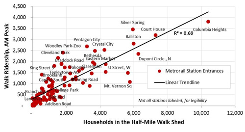
Households and walk ridership per Metro station. Image by WMATA.
Columbia Heights has by far the most households within walking distance. That makes sense. It’s one of DC’s densest neighborhoods, and the Metro station is right near its center.
But the number two most household-rich Metro station is Arlington’s Court House. Others in the top 5 are Ballston, Silver Spring, and Dupont Circle.
All 5 are among the 10 stations with the most riders who walk to the station each morning. The rest of the top 10 walking stations are Woodley Park, Cleveland Park, Pentagon City, Crystal City, and Bethesda.
More riders may be walking to jobs from the downtown stations, or from Rosslyn, but those are the destinations, where riders in the morning are getting off. The origin stations are the more residential ones.
All in all, Metro’s stations fit neatly along a trendline that shows a strong correlation between more households nearby and more riders arriving to stations by foot.
Even the outliers tell a story. U Street and Mount Vernon Square have the 6th and 7th highest number of households nearby, but they under perform on walking Metro ridership. One might speculate that Mount Vernon Square is so close to so many offices that more people simply walk. U Street is a little farther away, but it’s still close enough to downtown that buses and bicycles may be better options for a large portion of riders.
What else pops out as interesting?
Cross-posted at Greater Greater Washington.
Average Rating: 4.9 out of 5 based on 170 user reviews.
August 13th, 2014 | Permalink
Tags: demographics, land use, metrorail, transportation
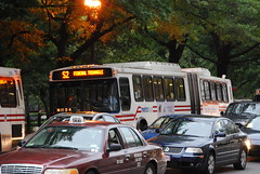
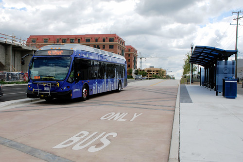
This bus is not in service. But it is running in Alexandria’s Metroway BRT corridor, presumably on a test run. It’s pretty exciting to see the region’s first BRT so close to starting.
The BRT opens for real on Sunday, August 24.
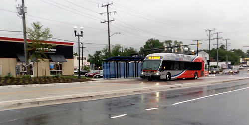
Cross-posted at Greater Greater Washington.
Average Rating: 4.6 out of 5 based on 226 user reviews.
August 12th, 2014 | Permalink
Tags: BRT, bus, transportation
DDOT isn’t yet willing to install a bus lane on 16th Street, but the agency is moving forward on a host of other improvements, and will study a bus lane next year.
The 16th Street bus line is bursting at the seams. It carries more than half of rush hour trips on 16th Street. But the buses are slow, and they’re so full that riders in the city’s close-in neighborhoods often can’t board.
Advocates have been pressuring for bus improvements on 16th Street since 2010. ANC Commissioner (and District Council candidate) Kishan Putta has championed the cause. Now, DDOT has adopted a 5-point plan to fix 16th Street.
Here are the 5 points:
Already complete: Signal optimization pilot program: In July 2014, DDOT retimed 44 of the traffic signals along 16th Street to improve their efficiency. After a few weeks of results, it appears to have sped up traffic (including buses). DDOT will continue to evaluate the results the rest of this summer.
August 2014: More articulated buses: Metro will reshuffle its bus fleet, to provide more long “accordion” buses on 16th Street. WMATA will move the articulated buses currently running on the Y series in Maryland to the 70 line in DC, then move the articulated buses currently on the 70 line to 16th Street. The Y series will have shorter buses, but they’ll come more often.
Fall 2014: Longer rush hour operations: DDOT is considering extending the hours of rush hour parking restrictions on 16th Street, to keep more travel lanes open up to an hour longer in each direction. That will keep two lanes open to moving traffic, including buses.
Mid 2015: Transit signal priority & full optimization: By mid 2015, DDOT will expand its signal optimization pilot program to the entire corridor, and install new software that instructs traffic signals to hold a green light a few seconds longer if a bus is about to pass through an intersection. That will speed up buses along the route, so they’re less likely to have to stop at red lights.
2015-2016: Bus lane study: Beginning in 2015, DDOT will begin a comprehensive study of transit improvements along 16th Street, including the potential for bus lanes and other long-term construction projects. The study will take about a year to complete, meaning 2016 is the earliest DDOT could install bus lanes.
None of these 5 points are new. DDOT has been working on them all for some time. But it’s good to have them listed all in one place.
Cross-posted at Greater Greater Washington.
Average Rating: 4.4 out of 5 based on 214 user reviews.
August 11th, 2014 | Permalink
Tags: BRT, bus, transportation
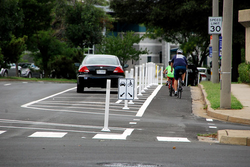
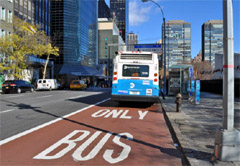
Simple plastic bollards and slight changes to lanes are enough to turn a regular bike lane into a cycletrack. Could the same trick work for bus lanes?
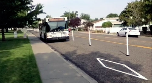
Bollard-protected bus lane in Washington state. Image from Zachary Ziegler on Vine.
DC’s 7th Street and 9th Street curbside bus lanes are famously dysfunctional. Cars use them at will, and pretty much always have. But it doesn’t have to be so.
The same tricks that work to protect bike lanes can also work to protect transit lanes. Plastic bollards, also known as flexposts, send a strong message to car drivers to stay out. The Virginia Department of Transportation even uses them on highways.
 |
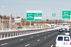 |
Flexposts on a Dulles Toll Road bus lane (left) and the Beltway (right).
Beltway photo from Google. |
Generally speaking, the same complications would exist for bus lanes as exist for cycletracks. Adding bollards takes up a couple of extra feet, parking for cars has to move a lane away from the curb, and you have to find a way to accommodate cars turning at intersections. But mixing zones and other clever solutions have solved those problems for cycletracks, and could work for bus lanes too.
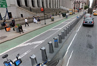
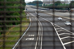
And flexposts aren’t the only cycletrack lesson we can apply to bus lanes. Red paint helps transit lanes the same way green paint helps bike lanes.
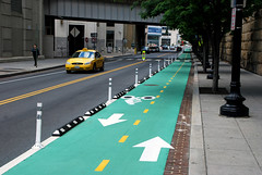 |
 |
| Green means bike, red means transit. Bus lane photo from NYDOT. |
No matter how many special treatments like bollards or red paint an agency applies, median transitways will still function better than curbside transit lanes. Median transitways eliminate the right turn problem altogether (left turns are less common), and puts the transit lanes out of the way of parked cars, or cars pulling over to pick up or drop off passengers.
But median transitways take up more road space, because the medians have to be wide enough for stations. They simply can’t fit on all streets. Where that’s the case, tricks like these can help curbside transit lanes work better than the 7th Street bus lane.
Cross-posted at Greater Greater Washington.
Average Rating: 5 out of 5 based on 291 user reviews.
August 7th, 2014 | Permalink
Tags: bike, BRT, bus, lightrail, streetcar, transportation
|
Media


Site
About BeyondDC
Archive 2003-06
Contact
Category Tags:
Partners
|