|
Special Features


Image Libraries


|
|
Blog
|
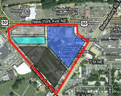
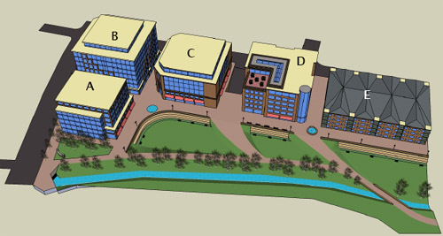
Approximate location and layout of the New York Avenue proposal. |
Ever since Wal-Mart announced earlier this week that they intend to build four stores in the District of Columbia, the question on the mind of urbanists has been: What will they look like?
This is the second of a four-part series examining the urban design of each proposal. The first part looked at the Brightwood location. Today: New York Avenue.
This proposal occupies most of the triangle bounded by New York Avenue, Bladensburg Road, and Montana Avenue. The site is 15 acres, which approaches the 20 acre average for a suburban Wal-Mart location.
According to developer Rick Walker, this site will have 360, 000 square feet of overall retail development, consisting of a 120, 000 square foot Wal-Mart (the largest of the four that will be in DC), one other big box retailer, and a number of smaller stores. The proposal does not call for residential or office.
Essentially, this will be a very tightly-packed power center.
The image, which I created based on Mr. Walker’s verbal description, shows approximately (very approximately) how the site will be laid out. The red line is the 15 acre property. The blue area is the two-story big box space. Wal-Mart will occupy the top floor, with primary access from Bladensburg Road. The other big box retailer will occupy the bottom floor, with primary access from New York Avenue. The dark gray area along Montana Avenue will be a multi-story parking garage. The teal area will be small-format retail, with surface parking in front shown in light gray, in more or less typical strip-mall form.
The ideal redevelopment for this corner would be a mixed-use town center that could induce a larger-scale transformation from suburban strip highway to walkable urban neighborhood. This part of town is crying for major improvements, and something along the lines of Clarendon Market Common might be the first step in such a reinvention.
Unfortunately, this proposal misses that opportunity.
On the other hand, it could also be a lot worse.
This corner is Washington’s most suburban in character. It is probably the one place in the entire District of Columbia where Wal-Mart’s traditional suburban approach might have worked. Although it’s unfortunate that the proposal won’t be transformative in the way a mixed-use project might be, it is at least good news that even here at this simplest of sites, we’ll be getting something better than the standard one-story asphalt ocean big box.
It seems likely that this will be the least urban out of the four proposals. If indeed this is as car-oriented as Wal-Mart’s plans for Washington get, at least it shows how far we’ve come since the Rhode Island Avenue Home Depot.
This one isn’t exactly urban, but it’s not Fairfax’s Wal-Mart either.
 Cross-posted at Greater Greater Washington. Cross-posted at Greater Greater Washington.
Average Rating: 4.6 out of 5 based on 285 user reviews.
November 23rd, 2010 | Permalink
Tags: architecture, development, master planning

|
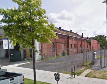
The Curtis Chevy car barn. Image from Google Street View. |
Ever since Wal-Mart announced earlier this week that they intend to build four stores in the District of Columbia, the question on the mind of urbanists has been: What will they look like?
Can Wal-Mart be fit into an urban context? Will we be getting walkable, transit oriented stores like the Columbia Heights Target, or the typical sprawly suburban model with acres of parking out front?
In all four cases the architecture is still in preliminary stages, making it impossible to obtain complete site plans. However, after speaking with the developers working on each of the projects, some information is nonetheless becoming available.
This post will be the first in a multi-part series discussing the urban design of each of the four stores. First up: the location in Brightwood, on the former site of Curtis Chevrolet, on upper Georgia Avenue.
Average suburban Wal-Marts often occupy sites with over 20 acres of land, but the Curtis Chevy property is barely four acres. Clearly, Wal-Mart won’t be able to build its usual model at this location.
Dick Knapp of Foulger-Pratt Company, the developer for the Brightwood site, confirms as much, saying “This is not your father’s Wal-Mart. They’re moving in to tighter spaces and they’re going vertical.”
The plans would replace the old car dealership buildings with a new 102, 000 square-foot Wal-Mart store. The only way to fit that large a store on that small a property is to eliminate surface parking and bring the building right up to the street, so that’s what will happen. It isn’t yet clear whether the entire store will be able to fit into a single story or whether a second floor will be necessary, but in any event the parking will be located in an underground garage directly below the store. The entrance will face the sidewalk 20-30 feet back from the curb. That will make for either a comfortably wide sidewalk or a narrow landscaped strip.
When asked about preservation of the existing buildings, Knapp responded that due to a now-canceled redevelopment plan for the property that would have replaced the car dealership with 399 apartments, Foulger-Pratt has already received city approval to demolish all the buildings on the site except the facade of the car barn, a historic structure used by the dealership to store vehicles. Wal-Mart is hoping to obtain permission to take down that facade as well, but such permission has not yet been secured.
Unfortunately, the development won’t be mixed-use. If Foulger-Pratt would stick a few floors of apartments above the retail uses, that would add new customers for the surrounding businesses and help revitalize central Brightwood as a place to live, not only to shop. It’s regrettable that the plan misses such an opportunity.
The goods news, though, is that Wal-Mart appears dedicated to providing a fundamentally urban store at this location. It will greet the street and it will not have any surface parking out front. These are real victories for the community, and represent a real evolution for Wal-Mart as a corporation.
Important questions do remain. Will the car barn facade be preserved? Will Wal-Mart’s frontage along Georgia Avenue be an uninterrupted blank wall, or will the architects take steps to give it pedestrian-scaled details? What sort of effect will Wal-Mart have on Brightwood’s independent businesses, and what will be their labor practices?
But from an urban design standpoint, we may be looking at one of the most progressive and walkable Wal-Mart designs in America. That, at least, is good news.
Cross-posted at Greater Greater Washington.
Average Rating: 5 out of 5 based on 260 user reviews.
November 21st, 2010 | Permalink
Tags: architecture, development, master planning, preservation
The Southwest Waterfront master plan, released yesterday, adds to an impressive collection of plans and development that could collectively transform the way we think about the area south of the National Mall.
One day, not too many decades from now, Southwest (and Near Southeast) could become a second downtown for DC, as large as the existing downtown area.
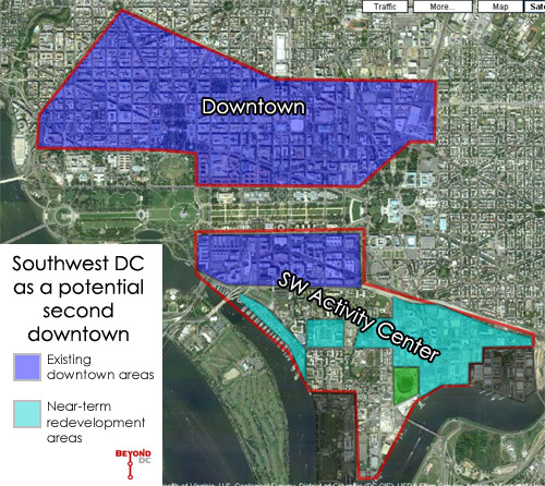
Consider the map above. The teal areas are, from left to right, the Southwest Waterfront, Waterfront Station, and the M Street Corridor, all of which are either rapidly redeveloping or soon will be.
After those areas have developed at downtown-like intensities, it’s likely that the gaps in between will gradually become part of this second downtown as well. The area could ultimately comprise as much as 100 million square feet of residential and office development — equivalent to the existing downtown.
This doesn’t mean existing apartments will be bulldozed wholesale, as the federal government did to create the Southwest Federal Center and L’Enfant Plaza areas. This won’t be a sudden change. Instead, it would happen gradually over many decades, as individual property owners want to redevelop their sites, just as happened at Gallery Place, the Golden Triangle, and the West End and is now happening in NoMA and the Mount Vernon Triangle.
As in those areas, the more historic blocks can be preserved, but only a minority of the buildings in Southwest and Near Southeast are historic. (In large part, this is because the federal government razed the really historic parts of the area long ago.)
Accommodating future development as close to the core of the city as possible is the most efficient, environmentally friendly, and economical way for us to grow. Building a second downtown as close to the Capitol as the existing downtown would be a historically great achievement in Smart Growth, and a far better regional solution than putting that same growth in, say, Loudoun County.
If this is indeed the future of our city, it is a good one. Some people won’t like it, but the alternatives of either pushing growth to the suburbs or tearing down even more historic and well-loved neighborhoods are not acceptable. No where else in the region can we achieve so very much with such relatively little sacrifice.
Cross-posted at Greater Greater Washington.
Average Rating: 4.6 out of 5 based on 298 user reviews.
October 1st, 2010 | Permalink
Tags: master planning
|
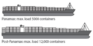
Much larger ships will soon be able to sail through Panama, increasing traffic at east coast ports. |
I live-tweet the monthly meeting of the Transportation Planning Board. This month there were a number of items that I think folks might like to see in more-than-140-character detail:
- The Board reviewed and accepted the first-ever National Capital Region Freight Plan (pdf), which discusses rail and trucking issues in the region. When the Panama Canal expansion project is completed in 2015, it will dramatically expand the tonnage of material shipped to east coast ports from Asia, which in turn means the amount of freight carried inland from ports like Norfolk and Baltimore will dramatically expand as well. To deal with this expected increase and still accommodate passenger rail, regional rail providers are working to expand their capacity any way they can. These strategies are discussed in the report.
- Each year the TPB provides a series of planning grants to local jurisdictions aimed at improving the connection between transportation and land use. This year the Board approved 8 projects (pdf), listed below:
- Van Ness Metro access and commercial corridor enhancement
- Best practices in providing concurrent bicycle and streetcar facilities in the same corridor
- Pedestrian facility standards for mixed-use developments in Prince William County
- Integrating freight rail with other land uses in Frederick
- Potential TOD scenarios for the US 29 / Cherry Hill area of Montgomery County
- Prince George’s County Central Avenue TOD scenarios
- Naylor Road Metro accessibility
- Safe walkways to transit in Rockville
- The Board received a briefing about the state of the commute survey (pdf), a study of commuting trends in the DC area. The survey presentation includes a lot of interesting information and is worth skimming. I’ve republished one page from it below. The implication that transit mode share is rising regionally is certainly a very significant piece of information.
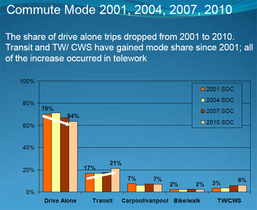
Regional commuter mode share over time.
Click the image to download the presentation.
Average Rating: 4.6 out of 5 based on 258 user reviews.
July 21st, 2010 | Permalink
Tags: environment, master planning, The New America, transportation
The National Park Service has released its new Master Plan for the National Mall. I have only briefly skimmed it so far, but one interesting page deals with the visual vistas NPS deems important. Check out this map:
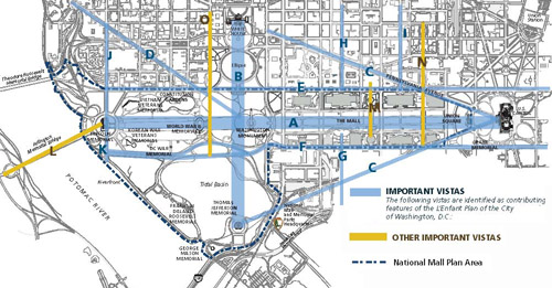
Important vistas according to NPS. Click the map for a larger version in pdf format.
The map’s blue lines are “vistas [that] are identified as contributing features of the L’Enfant Plan of the City of Washington, D.C.”, while the yellow lines are “other important vistas”.
This could prove important for streetcar planning if indeed DC solves its overhead wire problem by adopting the common sense hybrid solution, whereby wires power trams for most of their routes, with short gaps at the most important vistas.
If the National Park Service’s plans can be considered authoritative, this map illustrates how they affect the 7th Street / 14th Street / Georgia Avenue streetcar line (the only one to cross the National Mall):

Streetcar conflicts with NPS vistas.
Such incidental conflicts can be easily avoided with existing, inexpensive battery technology, while still allowing the most affordable and efficient power system (wires) to be used throughout most of the system. It’s a real win-win idea.
Average Rating: 4.4 out of 5 based on 205 user reviews.
July 15th, 2010 | Permalink
Tags: master planning, streetcar, transportation
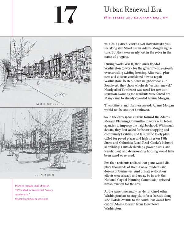
Given the post earlier this week about Washington’s unbuilt highways, I thought it would be interesting to republish this discussion of mid-century urban renewal from the Adams Morgan Heritage Trail Booklet. The booklet is available free to download from Cultural Tourism DC, and is similar to the historic marker on the sidewalk in Adams Morgan.
Click the image to download the booklet in pdf form.
Average Rating: 4.6 out of 5 based on 230 user reviews.
July 2nd, 2010 | Permalink
Tags: architecture, history, master planning, preservation, urbandesign
This evening the Fairfax County Board of Supervisors will hopefully approve a long range redevelopment plan for Tysons Corner. In a post at the Washington Post Local Blogging Network, I argue that the only sensible action is to raise density in Tysons to the point where it can begin to function like a genuine city, where walking and transit are as easy or easier than driving.

Image from draft Tysons plan.
Update: The Board approved the plan by 8-2 vote. – June 23
Average Rating: 4.7 out of 5 based on 193 user reviews.
June 22nd, 2010 | Permalink
Tags: master planning, washpostblog
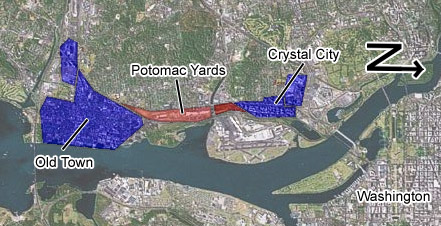
Alexandria has approved a rezoning for Potomac Yard that will, over time, convert what is probably the largest strip mall inside the Beltway into a bona fide mixed use urban neighborhood. Along with the Arlington portion, redevelopment in Potomac Yard will finally stitch together the walkable nodes of Crystal City and Old Town Alexandria into one continuous 5-mile long corridor of urbanity.
By just about any measure, this new conglomeration will be the largest mass of walkable urbanism in the region, after central DC.
A complete 5-mile-long urban corridor
Average Rating: 4.6 out of 5 based on 223 user reviews.
June 15th, 2010 | Permalink
Tags: master planning, urbandesign
As Arlington County prepares a redevelopment plan for East Falls Church, the City of Falls Church is considering its own options. One possibility is to use Four Mile Run as the centerpiece of an East Falls Church Waterfront District.
Yes that’s right, a waterfront district. Falls Church may be 6 miles from the Potomac, but why let that stop them?
The waterfront plan was prepared by Virginia Tech students as an academic exercise, but the idea so intrigued Falls Church city leaders that they are seriously considering it as a vision for future planning.
The idea is to redevelop the low-density industrial block between West Jefferson Street and Four Mile Run (see map) as a series of mid-rise mixed-use buildings, with a park along the side of the creek.
Rendering of a possible East Falls Church waterfront at Four Mile Run
In truth, it will take years for the City of agree to a plan, convince the landowners, find a developer, get financing, and construct the project. This is an idea, not an action proposal. But it’s a really good idea that seems to have legs. It meshes well with other likely redevelopment around the East Falls Church Metro, and could in the long term be a real winner.
It’s definitely something to keep an eye on.
Cross-posted at Greater Greater Washington.
Average Rating: 4.4 out of 5 based on 194 user reviews.
June 11th, 2010 | Permalink
Tags: master planning, proposal
|
DRPT’s vision. Blue lines are light rail. |
When I put together the BeyondDC Hampton Roads Transit Vision last week, I had no idea that Virginia’s Department of Rail and Public Transportation adopted a similar vision last year.
DRPT’s official vision is shown at right and is available for download. It more or less duplicates BeyondDC’s Virginia Beach and Naval Station extensions of the light rail starter line, but veers dramatically from my plans from there. Absent is any line to the airport, but present are lines to the peninsula, and a more logical Portsmouth connection.
Good on DRPT for such a forward-thinking document.
Tomorrow BeyondDC will share some more of DRPT’s recent planning work, this time from Northern Virginia.
Average Rating: 5 out of 5 based on 186 user reviews.
February 1st, 2010 | Permalink
Tags: BRT, lightrail, master planning, transportation
|
Media


Site
About BeyondDC
Archive 2003-06
Contact
Category Tags:
Partners
|


