Special Features

Image Libraries

Blog

click to enlarge
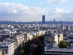
Paris and its Tour Montparnasse.
Image by Sean Marshall on flickr.

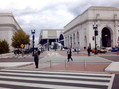
In recent years there has been a lot of discussion about raising DC’s building height limit. Today that discussion moved into the realm of official policy-making, as Congress announced it will study the issue. Any change to the height limit would need Congressional sign-off.

In general I think the height limit should be raised subtly, in key places for key reasons, based on careful planning. I’m in favor of using taller buildings to incentivize more development where we want it, but don’t think it would be wise to simply eliminate the limit completely.

That’s sounds simple, but the issue is pretty complex. Here are some key points, with links to more expanded discussion:

  • Uptowns: Raising the limit in places like Anacostia and Tenleytown would encourage them to develop as uptowns, like Arlington and Bethesda.
  • Negatives: Raising the limit in downtown DC would increase pressure to tear down historic buildings, and decrease the pressure to fill in parking lots and other underused properties.
  • Tall =/= dense: Counterintuitively, midrise development is often more dense than skyscrapers.
  • Residential bonus: Giving developers a height bonus in exchange for building apartments instead of office would increase the vitality of downtown.
  • Do it, but carefully: We should raise the height limit with a scalpel, not a hatchet.
  • Trade-offs: Despite economic advantages, there are non-economic trade-offs about raising the height limit that we can’t ignore.
  • Be practical:: We should consider how to realistically improve the city’s regulations, not stake out dogmatic extremes.

Average Rating: 4.6 out of 5 based on 167 user reviews.

November 8th, 2012 | Permalink
Tags: government, land use, master planning, preservation, urbandesign


There has got to be a better way to hide fabric stains than the Saved by the Bell aesthetic.


Seriously though, let’s credit WMATA for not using this so much recently.
Image from reddit.

Average Rating: 4.9 out of 5 based on 245 user reviews.

November 8th, 2012 | Permalink
Tags: bus, fun, transportation


David Alpert contributed to this article.

Last night, DDOT released renderings of its design for the proposed Spingarn streetcar barn. The proposal is a passable building, but the design is likely to disappoint residents who’d been expecting great architecture.


Streetcar barn design. Image from DDOT.

DDOT originally wanted to locate the maintenance facility for its H Street streetcar under the Hopscotch Bridge, near Union Station. That proved impossible, so DDOT switched its plans to the most practical alternate site: the Spingarn High School campus.

Though the design lacks the ornament and detail of DC’s historic streetcar barns, it is typical of contemporary institutional architecture, which is a step up from the bare bones necessary for industrial buildings.

In fact, this design looks very much like a modern school. If DCPS were building a new education building on the same site, it would probably look pretty similar, at least as seen from Benning Road. Adjacent residents likely won’t feel they are living right next to an industrial facility.

However, it’s not the sort of civic architecture that leaves much of an impression. Many cities’ new car barns aren’t good civic architecture either, but DDOT has been suggesting that this building would be better than merely okay.

The design guidelines call for “the highest aesthetic quality, ” and there’s a lot that could be done to improve this building. Some of DC’s new libraries show how civic buildings can indeed be exemplary.


Image from DDOT.

Some changes can improve the design

The primary purpose of the barn will be to park and maintain streetcars, but it will also include a training center, offices, and employee prep areas. One nice touch in the building design is that those non-industrial uses line Benning Road, so that from the sidewalk the upper floors of the building look like a school or office instead of a warehouse. Unfortunately, the ground floor is bare, so the illusion is incomplete.

Design guidelines call for public art to be included, and these renderings don’t appear to have any. Perhaps that first floor wall would be a good location for a mural.

Another disappointing facet is the location of the public entry on the side rather than the front or corner, where most would expect it. The reason appears to be that the interior layout puts offices and a copy room at the street corner, pushing the entry back a few feet onto 26th Street. This seems needlessly confusing, and prioritizes the wrong function.

The Historic Preservation Review Board discussed the project on November 1. Their comments begin at the 2:00:00 mark on the archived video, and focus on whether or not a modern-looking building is appropriate, and whether the plan could be reduced to have less visual impact. They did not take any vote at that meeting, but will do so when they consider the landmark application for Spingarn later this month.

The streetcar project is important, and this car barn is good enough to not delay the project. But while this is pretty good for a building that’s basically a garage, it could be much better. A car barn on the Spingarn campus makes sense, and this one isn’t terrible, but residents asked for an exemplary building, and DDOT said it could deliver.

DDOT also needs to be more open to the public about its planning for the streetcar. These renderings came out at 4:30 pm the evening before a Presidential election. Given the concern neighbors have about the planning process for the car barn, DDOT must make every attempt to be as open as possible.

It’s not necessary to completely start over, but some improvements do seem in order. Likewise, as DDOT starts to plan for future car barns in other neighborhoods, they shouldn’t settle for “just okay.”

 Cross-posted at Greater Greater Washington.


Average Rating: 5 out of 5 based on 214 user reviews.

November 6th, 2012 | Permalink
Tags: architecture, development, preservation, streetcar, transportation, urbandesign


The new L Street cycle track has been getting lots of attention, but it’s not the only one to open in DC this fall. DDOT has also opened the first segment of the 1st Street NE cycle track, to much less fanfare.

The 1st Street cycle track will eventually go from Union Station north to M Street, where it will provide a handy connection to the Metropolitan Branch Trail (though there will be a 1 block gap). The part that’s been installed this fall is a short segment of only about 30 feet, right in front of Union Station.

It’s a bit of a mystery when this 30 foot stretch opened, but I happened to be at Union Station on Friday, and there was the cycle track.

Here are a couple of pictures:

Average Rating: 4.4 out of 5 based on 275 user reviews.

November 5th, 2012 | Permalink
Tags: bike, transportation


click to enlarge
Seattle’s Yesler Way bike sneak. Image by Alta Planning & Design.

Streetcar tracks can sometimes be dangerous for bicyclists to cross. A new type of intersection design called a “bike sneak” may reduce the risk, by directing cyclists to cross at the safest angle.

Streetcars and bicycles both promote livable urban communities. They can and do coexist in many cities around the world, most notably Amsterdam, which is a global leader for both bike and streetcar infrastructure. Nonetheless, the grooves of streetcar tracks are a potential danger to bicyclists, so careful planning is necessary where the two mix.

One possible solution is a so-called “bike sneak”. The safest way to cross streetcar tracks on a bike is to cross at a 90º angle, with the bike tires perpendicular to the tracks. A bike sneak is a special ramp that directs bicyclists onto a path that will take them across streetcar tracks in exactly the right perpendicular angle.

Seattle is experimenting with its first bike sneak now. They opened their first streetcar line in 2007, and have a 2nd under construction.

At one point along that 2nd line, the streetcar turns off of Seattle’s Yesler Way and on to 14th Avenue, jutting in the way of a bike lane on Yesler that continues straight without turning. Without some sort of special intersection design, the straight bike lane would cross the curving streetcar tracks at a dangerous angle that would be likely to snare many bike tires. Thus Seattle has installed a bike sneak, which directs bike riders to turn slightly in order to cross at a safe angle.


Yesler Way bike sneak. Image by Alta Planning & Design.

Seattle Bike Blog describes how it will work, and includes another picture:

“The bike lane will feed you up this curb for a couple feet, then let you back down to street level where the cone is on the far side. Paint will direct you across the tracks at a safe angle so you can carry on up Yesler.”


Yesler Way bike sneak. Image by Seattle Bike Blog.

Seattle Bike Blog notes that good signage and street markings will be necessary so bicyclists clearly understand what they’re supposed to do. That’s a good suggestion. Hopefully Seattle will add that, and the bike sneak will work.

Obviously this solution isn’t right everywhere. It doesn’t address places where bikes and streetcars run parallel to each other, for example. For those situations something else will be necessary. Seattle is putting in a cycle track, which is one solution. Another is bike boulevards on parallel streets, which is what Arlington is considering for Columbia Pike.

But surely as streetcar and bike lane installation both become more common, there will be cases in the Washington area where a bike sneak may be a good solution. When that day comes, maybe DC can use this idea.

 Cross-posted at Greater Greater Washington.


Average Rating: 4.9 out of 5 based on 222 user reviews.

November 2nd, 2012 | Permalink
Tags: bike, streetcar, transportation, urbandesign


The platform at NoMa Metro station is one of the best places in the United States to see passenger trains. Since NoMa is above ground just north of Union Station, visitors can see a steady stream of Amtrak, MARC, and VRE trains coming and going from Union Station. And with the US Capitol dome in the distance, there’s also the bonus of a nice setting.

A couple of weeks ago I happened to be there around rush hour, so I stuck around for 15 or 20 minutes and got a bunch of pictures. A few are shown here, with the full set of 24 on flickr.


Acela.

Amtrak Regional.

MARC.

VRE.

Average Rating: 4.9 out of 5 based on 233 user reviews.

November 1st, 2012 | Permalink
Tags: commuterrail, galleries, intercity, transportation


Media


Site
About BeyondDC
Archive 2003-06
Contact

Search:

GoogleBeyondDC
Category Tags:

Partners
 
  Greater Greater Washington
 
  Washington Post All Opinions Are Local Blog
 
  Denver Urbanism
 
  Streetsblog Network


BeyondDC v. 2013d | Email | Archive of posts from 2003-2006