|
Special Features


Image Libraries


|
|
Blog
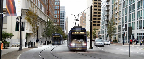
Arlington has two streetcar projects in planning. Columbia Pike has been in the works longer and received more press, but Crystal City is no less important. When they’re both up and running, they’ll most likely operate as a single line.
One key difference between them is that the Crystal City line will run in its own right-of-way, meaning it won’t have to share lanes with cars. Much of its transitway is already in place, and will open as a BRT line before the streetcar is ready.
Here’s the first rendering of streetcars in Crystal City, released in the project’s November newsletter.
Average Rating: 4.6 out of 5 based on 177 user reviews.
November 30th, 2012 | Permalink
Tags: BRT, lightrail, streetcar, transportation

|
Arlington’s Orange Line corridor. Home to tall buildings, and good for the region. |
The question over whether or not to raise DC’s height limit has come up periodically for several years, but gained new traction earlier this month when some members of Congress asked for a study about modifying the height limit legislation. With the possibility of actual change looming, more and more people are weighing in.
Most height limit opponents have so far based their position on the argument that taller buildings downtown would be more economically efficient, and that allowing some offices to be located outside downtown is costing DC a lot of money.
The latest to do so is David Schleicher at The Atlantic Cities, who opposes the height limit and poses a series of questions to supporters.
Having long advocated for raising the limit strategically, both downtown and in surrounding areas, I cannot be characterized as a height limit supporter. But I also think that the economic arguments put forth by the loudest height limit opponents, including Schleicher, are too narrow and miss important considerations.
> Continue reading
Average Rating: 5 out of 5 based on 184 user reviews.
November 28th, 2012 | Permalink
Tags: question, urbandesign
Phase 1 of the Silver Line is 83% finished, and on target for a summer 2013 completion. It will open in late 2013, after a few months of required testing by WMATA. During that time trains will sometimes be visible running on the tracks.
A construction contract will be awarded for Phase 2 in May 2013, with construction starting later that year, and completion anticipated in 2018.
In early November construction crews put in place the pedestrian bridge at Wiehle-Reston East station that crosses over the Dulles access highway. Here’s a photo from the interior:
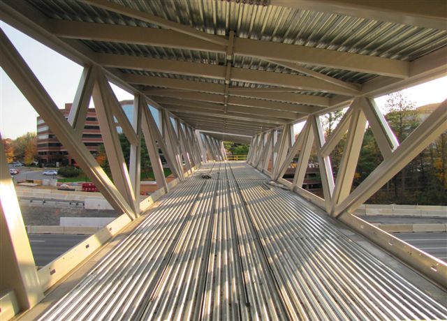
Photo by Chuck Samuelson of the Dulles Corridor Metrorail Project.
Average Rating: 4.4 out of 5 based on 273 user reviews.
November 27th, 2012 | Permalink
Tags: development, metrorail, transportation
|
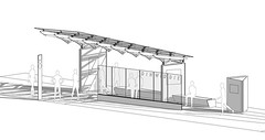
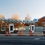
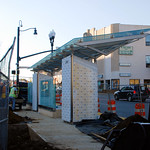
Rendering of a completed Super Stop. |
Arlington County has been planning a series of 24 “Super Stops” along Columbia Pike. The new bus stops will have expanded shelter and seating, electronic real-time arrival displays, maps, and a raised curb platform. They’re intended to be more like light rail stations than bus stops.
Eventually the Super Stops will actually be light rail stations for the Columbia Pike streetcar, but until that opens they’ll only serve buses.
The first Super Stop is under construction now, and beginning to take shape. It’s at the corner of Walter Reed Drive, and is scheduled to open in the coming weeks. Here are three pictures of the progress, taken last Wednesday.
Average Rating: 4.6 out of 5 based on 169 user reviews.
November 26th, 2012 | Permalink
Tags: bus, development, streetcar, transportation
|
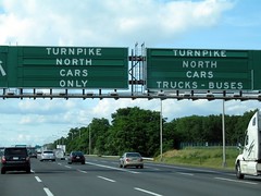
New Jersey Turnpike. By flickr user MPD01605. |
14 hours for a drive that should have been 5. That’s my record.
It was Thanksgiving weekend, 1992. I was 11 years old. My sister was a freshman attending college on Long Island, and my father and I were picking her up for her first holiday back home in suburban Maryland. The New Jersey Turnpike was a traffic jam.
No, not part of the New Jersey Turnpike. All of the New Jersey Turnpike.
We were bumper to bumper for the entire stretch, from the Verrazano-Narrows Bridge turn-off south all the way to Delaware. For more than 100 miles, we averaged about 10 mph. It was truly awful.
I’m thankful that I’m not doing that again. I’m thankful about the alternatives I’ve learned to use since then, and thankful I wasn’t driving during the 2011 snowstorm that resulted in nighmarishly long suburban commutes.
And for those of you on the turnpike: Godspeed.
Average Rating: 4.5 out of 5 based on 290 user reviews.
November 21st, 2012 | Permalink
Tags: roads/cars, transportation
The Beltway HOT lanes are officially open and in action. I went out yesterday afternoon to take a quick look, although I still haven’t driven on them.
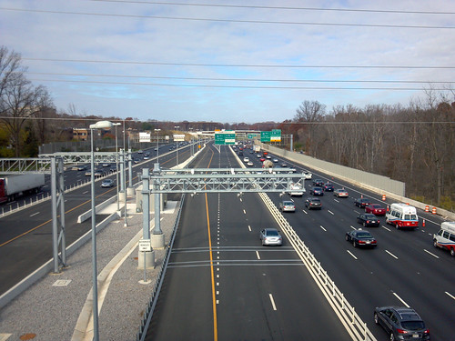
I-495 HOT lanes, at Lee Highway.
In this picture you’re looking north along I-495 from the US-29 overpass, in Merrifield. The metallic contraption hanging over the highway in the center of the image is the toll gantry, which reads EZpass signals from passing cars below. You must have an EZpass to use the lanes.
There is exactly 1 car visible using the HOT lanes in either direction, although the picture wasn’t taken during rush hour.
It will be especially interesting to see if these new express lanes help a transit culture develop in Tysons Corner. Tysons has more office space than downtown Baltimore, so there’s plenty of potential market. Buses will use the lanes on routes coming from Fairfax, Loudoun, and Prince William counties, and will undoubtedly have a better trip than they would in the general purpose lanes. But with a private company that hopes to maximize toll revenue in charge of the lanes, one wonders how well buses will be treated.
One thing is totally clear: There will still be traffic jams on the Beltway. HOT lanes will allow some drivers and transit users to bypass congestion, but if there aren’t traffic jams then no one would pay to use the HOT lanes, so the road’s owners wouldn’t make any money. The concept requires continued congestion in the general purpose lanes in order to work.
These things give people more options, so that’s good, but they won’t end congestion on the Beltway.
Average Rating: 5 out of 5 based on 204 user reviews.
November 20th, 2012 | Permalink
Tags: bus, events, roads/cars, transportation
|
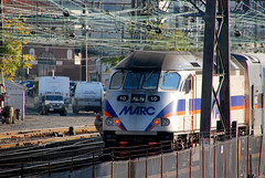
MARC. |
DC Councilmember Kenyan McDuffie tweeted yesterday that he wants the city to look into either a Metro or MARC station at the corner of New York Avenue and Bladensburg Road. Streetcar might be a better option.
That corner is easily the most suburban place west of the Anacostia River in DC, and maybe in the entire District, so it could certainly use a transit investment to help it develop a more urban character. But what sort of transit would make sense?
Metrorail is not a sensible solution, because there’s not a Metro line anywhere nearby. WMATA’s Brentwood rail yard is very close, so adding a new station at Bladensburg and NY Ave wouldn’t require all that much new track construction. But that would result in a 1-station spur of the Red Line, which would have limited usefulness. A bigger problem is that a new spur would decrease the capacity of the Red Line’s existing Silver Spring leg. Operationally it just wouldn’t make sense. And even if it did, a new Metro station would cost hundreds of millions of dollars.
MARC could be a good solution, because MARC’s Penn Line (the best one) does pass by just 1 block north of New York Avenue. An infill station there would be easy to build, and would provide about 60 trains per day. MARC stations are extremely simple, so this is something that could be accomplished relatively easily.
But 60 trains a day isn’t actually very many, if your goal is to induce transit oriented development. The relative simplicity of a MARC station makes it an attractive short term goal, but in the long term a better solution may be needed.
One mode McDuffie didn’t mention, but that maybe should be considered, is streetcar. None of DDOT’s proposed streetcar lines pass through here, but the H Street line and the Florida Avenue / 8th Street line are both close. It wouldn’t cost very much to add a spur from those lines that goes up West Virginia Avenue and ends at New York Avenue and Bladensburg Road, like this:
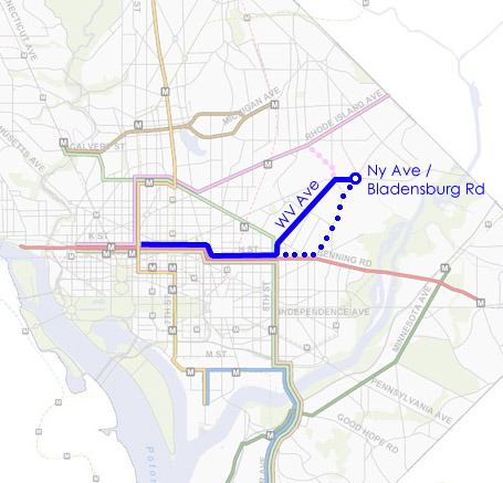
Potential new streetcar route, using portions of the H Street and 8th Street lines, with a spur up West Virginia Avenue. Dotted lines indicate alternate routes.
Another option for a streetcar spur would be to go up Bladensburg Road itself, breaking off from H Street at the Starburst intersection. That would better serve the Carver Langston neighborhood and National Arboretum, but wouldn’t be as good for Ivy City.
A third permutation could spur off of the Rhode Island Avenue streetcar, using Montana Avenue to cut south to New York Avenue. This might be the cheapest streetcar option, but it would also probably be the least useful, since it wouldn’t go to many new places.
DC has so many great transit projects in the works that anything will likely be hard to budget. Metro is probably not realistic at all, and a MARC station is the best bet for something soon. But a streetcar on West Virginia Avenue, Bladensburg Road, or Montana Avenue may well be something to shoot for.
 Cross-posted at Greater Greater Washington. Cross-posted at Greater Greater Washington.
Average Rating: 4.4 out of 5 based on 283 user reviews.
November 15th, 2012 | Permalink
Tags: commuterrail, metrorail, streetcar, transportation
The L Street cycle track is open, but the pavement markings continue to be confusing for some people. Car drivers planning to turn left off of L Street often don’t understand how to cross the cycle track into the turn lane, and instead stay in the travel lane only to cross in front of the bike lane at the intersection.
In response, twitter user @whiteknuckled proposes this modified painting scheme:
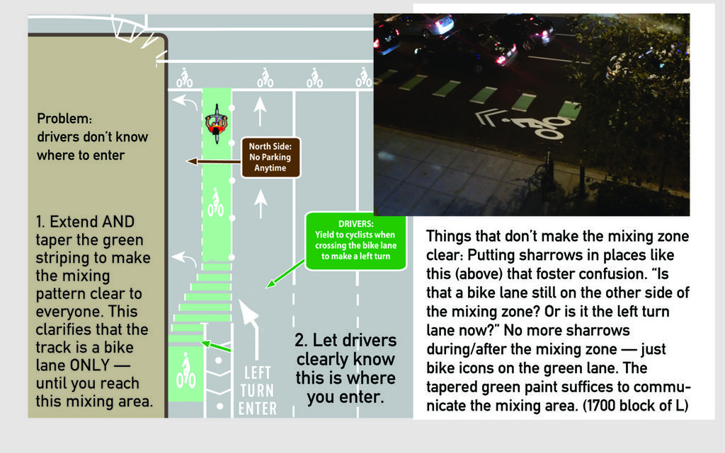
I am always in favor of more green paint on bike lanes, and this idea is no exception. However, the real key to solving this problem is the arrows on each car lane, especially the “left turn enter” one, which indicates to drivers where to cross over the bike lane. That’s the awkward movement, so that’s what needs to be clarified.
In a twitter response, DDOT notes that bikes turning left are also supposed to use the left turn lane, which is why they used sharrow markings in that area. But DDOT’s twitter rep also promised to pass along this idea to the bike team for their thoughts.
Cycle tracks are still a pretty new thing in the United States, so it’s natural that designers need to experiment a little with different options. DDOT deserves enormous praise for being on the very cutting edge of this field.
Other DOTs might have waited years until all these design questions are answered and there’s an adopted nationwide standard for every conceivable layout, but DC needs better bikeways now, and DDOT is doing its best to deliver. That’s great.
But it also means they may have to adjust the lanes as we learn how cyclists and drivers interact with it in the real world.
Ideally DDOT could apply both the turn markings and green paint section, as whiteknuckled suggests, but at a minimum, “left turn enter” markings for cars could make a big difference.
Cross-posted at Greater Greater Washington.
Average Rating: 4.8 out of 5 based on 202 user reviews.
November 14th, 2012 | Permalink
Tags: bike, roads/cars, transportation, urbandesign
In my humble and possibly biased opinion, Washington Union Station is the best train station in the US. A strong case could certainly be made for New York’s Grand Central, and there are plenty of other good ones around the country. But neither our Union Station, nor Grand Central, nor any of America’s largest or most active train stations, have a great train room. There are some small US stations that still have train sheds, such as Harrisburg, but they aren’t grand public spaces like in Europe.
But soon that will change. Denver is building a new train shed on the back of its historic Union Station, in support of a massive regional light rail and commuter rail expansion. And it’s going to be super cool. Construction has been ongoing for quite a while, but over the last week crews have started to put up the train shed itself. You can watch them at work and keep up with progress using the construction webcam.
Here’s what the train room will look like when done:
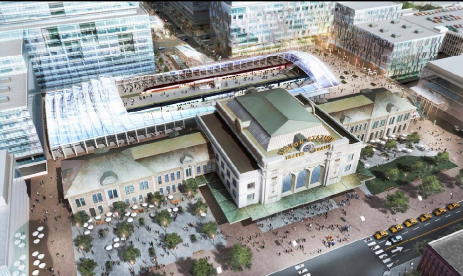
Image from the Denver Union Station Project Authority.
And here’s their construction progress, as of this morning:
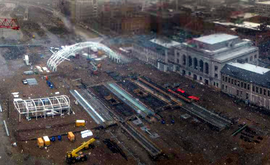
Webcam image from Kiewit Construction.
Average Rating: 4.7 out of 5 based on 183 user reviews.
November 12th, 2012 | Permalink
Tags: architecture, commuterrail, development, intercity, lightrail, transportation
|
Media


Site
About BeyondDC
Archive 2003-06
Contact
Category Tags:
Partners
|


