|
Special Features


Image Libraries


|
|
Blog
The first of 70 new Amtrak locomotives rolled off the assembly line yesterday. They will fully replace all the locomotives on Amtrak’s non-Acela Northeast Regional trains, and can reach a top speed of about 125 miles per hour. Expect to start seeing them in service between DC and Boston this autumn.
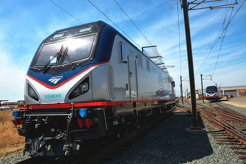
Amtrak’s new “ACS-64″ locomotive. Photo from Amtrak.
Average Rating: 5 out of 5 based on 257 user reviews.
May 14th, 2013 | Permalink
Tags: intercity, transportation

WMATA has settled on a brand for its upcoming Crystal City Potomac Yard BRT line. It will be called Metro Way, and it will feature a flashy new blue paint scheme.
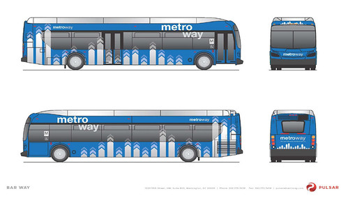
Metro Way. Image from WMATA.
The BRT line will run from Pentagon City through Crystal City and then into Alexandria. It will have dedicated lanes, with large rail-like stations, and will run every 6 minutes during rush hour, and every 12-15 at other times.
In a few years it will be upgraded to streetcar. But in the mean time, it’s the DC region’s first bona fide BRT.
WMATA selected the Metro Way brand and livery following a survey this past March that considered several options. The blue livery, although clearly unique, reflects Metro’s use of blue for its MetroExtra express buses.
 Cross-posted at Greater Greater Washington. Cross-posted at Greater Greater Washington.
Average Rating: 5 out of 5 based on 195 user reviews.
May 10th, 2013 | Permalink
Tags: BRT, transportation
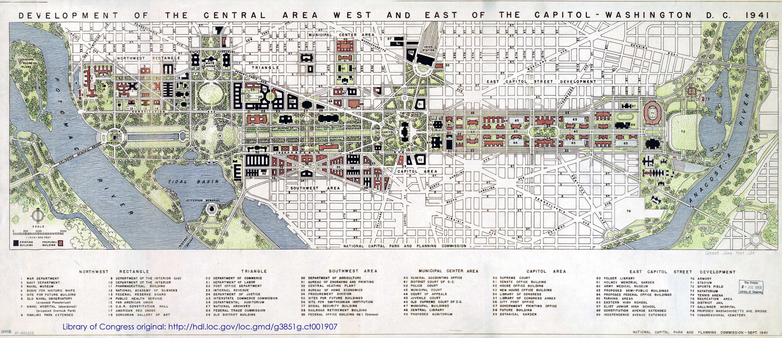
DC’s 1941 master plan is available through the Library of Congress. Published just months before Pearl Harbor, the plan is a fascinating look at the future pre-war planners envisioned.
The National Mall extends eastward to the bank of the Anacostia and dominates the plan. “Semi-public buildings, ” parking garages, and much more highway-like Constitution and Independence Avenues line the new Mall. On the other hand, Southwest retains its historic street grid, and isn’t cut off by I-395.
What else jumps out?
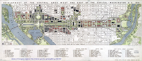
Image by National Capital Park and Planning Commission.
Cross-posted at Greater Greater Washington.
Average Rating: 4.5 out of 5 based on 296 user reviews.
May 9th, 2013 | Permalink
Tags: history, master planning, parks, roads/cars, transportation
The Yangtze River valley between Shanghai and Nanjing is one of China’s densest and most heavily populated regions. It’s also one of its most agriculturally rich. Just like in America, sprawl claims much of the land between cities in the megapolis, but unlike America, the sprawl is happening in a way that preserves much of the land as functioning farms.
This aerial shows how walking along one of those streets, one might never know the neighborhood is primarily farmland.
More pictures.
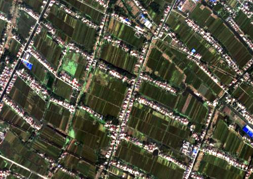
From google maps.
Average Rating: 4.5 out of 5 based on 161 user reviews.
May 8th, 2013 | Permalink
Tags: land use, preservation
A proposed skyscraper in Tysons Corner will be 435 feet tall, making it the tallest in the DC region, and first to breach the 400 foot threshold. The building is proposed as part of the SAIC redevelopment, adjacent to the Silver Line’s Greensboro Metro station.
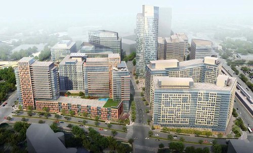
SAIC Westpark. Image by FXFOWLE, published online by The Tysons Corner.
Traditionally, the tallest skyscrapers in the region have been in Rosslyn. But Rosslyn is in the flight path to National Airport, so buildings there can’t rise higher than 400 feet. A bevy of development projects in Rosslyn, Alexandria, Tysons, and North Bethesda are in the 300-400 foot range, but this is the first serious proposal to crack 400 feet.
Outside the DC region, Maryland’s tallest building is 528 feet, and Virginia’s is 508 feet. Richmond’s is 449 feet.
Cross-posted at Greater Greater Washington.
Average Rating: 5 out of 5 based on 251 user reviews.
May 7th, 2013 | Permalink
Tags: development
Walkable City describes the benefits of urbanism, and proscribes how to make good urbanism happen. It’s a worthy read, for both newbies and hardened Jane Jacobs veterans.
I don’t read many mass market city planning books anymore, because so many of them say the same things. But when I heard one of the authors of Suburban Nation had his own book, I had to give it a shot. Suburban Nation is still the most eminently readable and easy to understand discussion of 20th Century suburbs, and why urban neighborhoods are better.
In some ways, Walkable City is like all those other books. It says mixed use and transit are good, wide highways and blank walls are bad. Most of us in the city planning world already know these things.
But Walkable City is worth reading, because Speck gathers a mountain of data supporting most of the arguments in contemporary urbanism, and then presents it in a convincing, methodological, and easy to read way. If you already know the basics, Walkable City is the most complete reference available.
And it does have new arguments. For example, Speck’s discussion of walkable architecture is intriguing, and explains in detail why it isn’t the ornament of historic buildings that makes them superior to most contemporary ones, but that they have layers of interesting things to look at, from different scales, and that walkers can interact with them in ways other than staring at a wall (even a decorated one).
Maybe I just like the book because I’m in it. Much to my surprise. I was reading it one day on the Metro and then, unexpectedly, on page 58, saw my own name, quoted regarded LEED architecture.
But perhaps the best thing I can say about Walkable City is this: After reading the first couple of chapters in a cafe, I went home, got a pen, and started over. Now my copy is covered with notes and squiggles from front to back.
Average Rating: 4.8 out of 5 based on 195 user reviews.
May 6th, 2013 | Permalink
Tags: people, urbandesign
DC’s next cycle track is slated to open this August, along M Street in downtown DC. The M Street lane will serve people riding westbound, complementing the eastbound-only cycle track a block away on L Street.
Lots of people use the L Street lane, but cars and trucks frequently block it, and the mixing zones where cars cross the bike lane to turn can be confusing. Planners are learning from how L Street works, and will try some different designs on M.
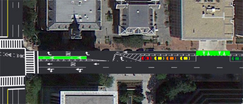
Proposed M Street cycle track at 17th Street, NW. Image by DDOT.
The bike lane itself will be slightly narrower, and a row of parking will separate the bike lane from the general travel lanes in some places. Mike Goodno, bike planner for the District Department of Transportation (DDOT), expressed hope these elements will dissuade people from driving or parking in the lane.
Both lanes are on the north side of their respective streets, which means that while L Street’s is on the left, the M Street bike lane will be on the right. In addition to full-time parking along most of the lane, blocks where M Street is wider will also have part-time parking on the south side.
Because there’s an extra lane in between, the mixing zones on M Street will be totally different. Instead of the gradual merge of L Street, drivers will turn toward the bike lane at a sharper angle, and are supposed to yield to bikes before crossing into the right turn lane. New York uses a similar arrangement for its Grand Street cycle track.
 
Mixing zones on L (left) and New York’s Grand Street (right). Photos from Streetsblog.
One trade-off is there’s no more green paint in the mixing zone. However, the spaces in front of driveways will be green, to make it clear to drivers they’re not supposed to stop in the bike lane.
At some corners, like 22nd Street, there won’t be a mixing zone. Instead, drivers cross the cycle track during an exclusive signal phase, like on 15th Street.
According to Goodno, many of the changes come simply because M Street is wider than L, offering more room to try different options for the lane. If they work well, some could make their way back to L Street.
DDOT will present its plans and accept public comments at a public meeting on Wednesday, May 15, 6:30-8:30 pm at the West End Library.
Cross-posted at Greater Greater Washington.
Average Rating: 4.5 out of 5 based on 219 user reviews.
May 3rd, 2013 | Permalink
Tags: bike, transportation
This map, produced by the Transportation Planning Board, shows “managed highway lanes” in the DC area. That’s planner jargon for HOV and tolls.
It’s only highways. It doesn’t show non-highway HOV, like along Route 1 in Alexandria. The map also appears to show I-495 incorrectly, since the Beltway HOT lanes are free for HOV-3.
But it’s still interesting to see which highways have special characteristics. One thing that pops out is how Virginia has a fairly comprehensive and interconnected network, while Maryland is more hit-or-miss.
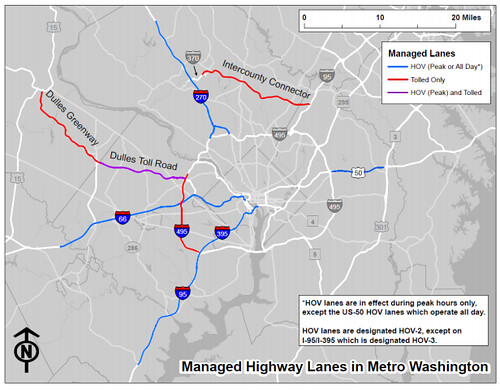
Managed lanes in the DC region, by TPB.
Average Rating: 4.9 out of 5 based on 164 user reviews.
May 2nd, 2013 | Permalink
Tags: maps, roads/cars, transportation
The DC Taxicab Commission today officially released their latest proposal for a uniform citywide taxi paint scheme. What do you think?

Image by DC Taxicab Commission.
This new design follows 4 previous options that had been proposed in December, and were widely criticized.
Here’s another view:
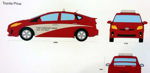
Image by DC Taxicab Commission.
Cross-posted at Greater Greater Washington.
Average Rating: 4.5 out of 5 based on 184 user reviews.
May 1st, 2013 | Permalink
Tags: roads/cars, transportation
|
Media


Site
About BeyondDC
Archive 2003-06
Contact
Category Tags:
Partners
|


