|
Special Features


Image Libraries


|
|
Blog
|
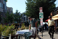
Seattle’s Yesler Way bike sneak. Image by Alta Planning & Design. |
Streetcar tracks can sometimes be dangerous for bicyclists to cross. A new type of intersection design called a “bike sneak” may reduce the risk, by directing cyclists to cross at the safest angle.
Streetcars and bicycles both promote livable urban communities. They can and do coexist in many cities around the world, most notably Amsterdam, which is a global leader for both bike and streetcar infrastructure. Nonetheless, the grooves of streetcar tracks are a potential danger to bicyclists, so careful planning is necessary where the two mix.
One possible solution is a so-called “bike sneak”. The safest way to cross streetcar tracks on a bike is to cross at a 90º angle, with the bike tires perpendicular to the tracks. A bike sneak is a special ramp that directs bicyclists onto a path that will take them across streetcar tracks in exactly the right perpendicular angle.
Seattle is experimenting with its first bike sneak now. They opened their first streetcar line in 2007, and have a 2nd under construction.
At one point along that 2nd line, the streetcar turns off of Seattle’s Yesler Way and on to 14th Avenue, jutting in the way of a bike lane on Yesler that continues straight without turning. Without some sort of special intersection design, the straight bike lane would cross the curving streetcar tracks at a dangerous angle that would be likely to snare many bike tires. Thus Seattle has installed a bike sneak, which directs bike riders to turn slightly in order to cross at a safe angle.

Yesler Way bike sneak. Image by Alta Planning & Design.
Seattle Bike Blog describes how it will work, and includes another picture:
“The bike lane will feed you up this curb for a couple feet, then let you back down to street level where the cone is on the far side. Paint will direct you across the tracks at a safe angle so you can carry on up Yesler.”

Yesler Way bike sneak. Image by Seattle Bike Blog.
Seattle Bike Blog notes that good signage and street markings will be necessary so bicyclists clearly understand what they’re supposed to do. That’s a good suggestion. Hopefully Seattle will add that, and the bike sneak will work.
Obviously this solution isn’t right everywhere. It doesn’t address places where bikes and streetcars run parallel to each other, for example. For those situations something else will be necessary. Seattle is putting in a cycle track, which is one solution. Another is bike boulevards on parallel streets, which is what Arlington is considering for Columbia Pike.
But surely as streetcar and bike lane installation both become more common, there will be cases in the Washington area where a bike sneak may be a good solution. When that day comes, maybe DC can use this idea.
 Cross-posted at Greater Greater Washington. Cross-posted at Greater Greater Washington.
Average Rating: 4.7 out of 5 based on 246 user reviews.
November 2nd, 2012 | Permalink
Tags: bike, streetcar, transportation, urbandesign

|
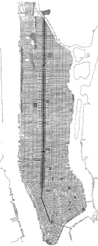
Flagg’s 1904 proposal. Image from Cornell University. |
New York’s Central Park is probably the most famous urban park in America, but it might have been a very different place if a proposal in 1904 had been advanced.
Take a look at the image at right, which shows a Central Park redesign proposed by Ernest Flagg in 1904. The proposal maintains exactly the same amount of park land, but arranges it differently. It’s only 1/3 the width, but it’s 3 times as long.
The mere thought of changing Central Park so radically invokes gasps of disbelief and horror, but would this have been so bad? There would have been both positives and negatives.
Positives
One big problem with Central Park is that it’s only within walking distance of a small part of Manhattan. This redesign would have made park space more accessible to more people, by extending Central Park to be within walking distance of almost the entire island, except for the southern tip.
This Central Park might also have drawn more people to more active uses. The busiest and most-used sections of parks are usually near their edges, where they meet the city. Since this proposed redesign has more edges, it would have more edge activities, and might therefore draw more people. Imagine if Bryant Park or Washington Square Park went on for blocks.
This version of the park would also probably never have developed the night time crime problems that Central Park has sometimes had, also because of that edge effect. Or at least, crime in the park probably wouldn’t have been much worse than crime elsewhere in Manhattan. Since the entire park would always be visible from the street, criminals wouldn’t have so many places to lurk, and crimes would be more likely to be witnessed.
Negatives
The most obvious negative would be that a narrow Central Park could not offer any escape from the city. With the closest street never more than a block away, Manhattan would not have any public spaces that feel separate from the hustle and bustle. This park would be a much less natural-looking one.
Another big negative is that this park might have been destroyed during the road-building craze of the mid 20th Century, leaving Manhattan with nothing. It would have made the perfect location for a Robert Moses expressway, and even if Moses never got his hands on it, it’s still very easy to imagine such a long narrow space being re-purposed as an excessively wide avenue, like 9 de Julio Avenue in Buenos Aires. Nobody would argue that 9 de Julio is better than Central Park, but if the 1904 proposal went forward that might have been the result.
Overall, the temptation under this redesign to turn over park space for cars would have been even greater than in real life. It might have proven too much.
Thanks but no thanks
So at the end of the day, it’s probably a good thing that New York stuck with its original Central Park placement. There is a slim but legitimate chance that Flagg’s proposal might have turned out better, but the odds that it would have been worse are very strong. And in any event, New Yorkers would have lost their treasured natural escape.
Average Rating: 4.4 out of 5 based on 226 user reviews.
October 9th, 2012 | Permalink
Tags: urbandesign
Usually when it comes to dedicated street lanes for transit and bicycles, the more physical separation from car lanes there is, the better off you are. Better physical separation is why cycle tracks are better than regular bike lanes, and why busways are better than striped bus lanes.
Unfortunately, physical separation adds complexity and cost, so it’s not used as often as it might be.
That in mind, take a look at this picture from Guadalajara, Mexico, where a very affordable measure of physical separation has been added to a bus lane:

Photo by SoCalMetro on flickr.
This solution wouldn’t work in a lot of places for a lot of reasons, and even where it would work it isn’t as good as the expensive heavily-engineered options. But nevertheless it’s a cheap way to squeeze some separation into some bus lanes. It’s worth considering, wherever there isn’t a need for cars to cross over the bus lane, and where a more expensive solution isn’t practical.
The first cycle tracks in the US were heavily engineered and expensive, but we quickly learned that they needn’t be. Maybe it’s time to ask whether that same lesson can apply to busways.
Average Rating: 5 out of 5 based on 201 user reviews.
October 4th, 2012 | Permalink
Tags: BRT, bus, transportation, urbandesign
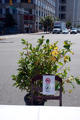
Grass track beds can make light rail systems a lot prettier, and so a lot of places use them. But check out this bit of creative thinking out of Houston, where they use water:

Main Street Square, Houston. Image by Google Street View.
Update: Apparently this doubles as a fountain. Here’s a picture with the water flowing. Hat tip to @FixWMATA.
Average Rating: 4.4 out of 5 based on 242 user reviews.
October 2nd, 2012 | Permalink
Tags: lightrail, transportation, urbandesign
My favorite street space from Park(ing) Day comes from Dallas, which took the event very seriously. Chairs and little patches of grass are nice, but I love the creative thinking that resulted in a book exchange:
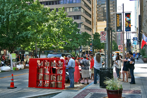
Photo by C Troy Mathis on flickr.
Average Rating: 4.4 out of 5 based on 229 user reviews.
September 28th, 2012 | Permalink
Tags: events, fun, urbandesign
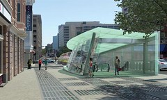
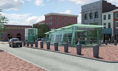
When the Baltimore Red Line is built, it will include 5 subway stations through the central city. Earlier this month Maryland’s project planners released renderings of what the subway portals will look like, reproduced below.
It sure will be great when Baltimore has a better transit system.
Average Rating: 4.8 out of 5 based on 188 user reviews.
September 25th, 2012 | Permalink
Tags: lightrail, transportation, urbandesign
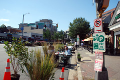
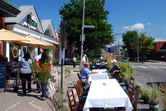
For Park(ing) Day today, Arlington converted a block of Wilson Blvd parking spaces into a row of outdoor cafe seating. The setup will be in place this evening until around dusk.
Here are some pictures:
Average Rating: 4.6 out of 5 based on 273 user reviews.
September 21st, 2012 | Permalink
Tags: events, galleries, roads/cars, transportation, urbandesign
|

DDOT’s options for transit lanes or cycle tracks on M Street. Why not both? |
Last week DDOT released its initial study of alternatives for M Street SE/SW. The study identifies 3 options for how the street might be redesigned, including options that include dedicated transit lanes and cycle tracks. However, none of DC’s options include both transit lanes and cycle tracks.
In a joint editorial published today at Greater Greater Washington, David Alpert and I discuss why DDOT used this strategy, and how the next round of planning can and should combine aspects of the existing 3 alternatives to form new and better multimodal options.
>> Go to GGW and read the editorial.
(Link fixed.)
Average Rating: 4.8 out of 5 based on 197 user reviews.
September 18th, 2012 | Permalink
Tags: bike, bus, development, metrorail, proposal, roads/cars, streetcar, transportation, urbandesign
|
Alexandria’s proposed Hoffman Towers. Image by DCS Architects.

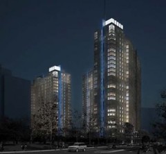
North Bethesda Market II, soon to be the tallest building in the Maryland suburbs. Image from JBG.

Reston’s next tallest building. Image from RTC Partnership. |
Within the confines of the District of Columbia, the question of whether to allow tall buildings is a subject of much debate. But in the burgeoning urban centers of Northern Virginia and suburban Maryland, there is no question: more tall buildings are coming.
For many decades Rosslyn has been home to the tallest skyscrapers in the Washington region. The taller of its Twin Towers is 381 feet tall. But soon that building will rank no better than 3rd tallest in Rosslyn alone, with the 384 foot tall 1812 North Moore and the 387 foot tall Central Place in construction or soon to begin.
Even with those new buildings, Rosslyn could soon lose its crown. Buildings as tall as 396 feet could soon be built around the Eisenhower Metro station in Alexandria. They would eclipse Alexandria’s current tallest building, the 338 foot tall Mark Center Hilton.
Tysons Corner is in on the action too. It’s tallest buildings right now are the 254 foot Ritz Carlton and the 253 foot 1850 Towers Crescent. But at 365 feet, a building in the proposed Scotts Run Station development will soon dominate.
In Maryland, North Bethesda Market I topped out last year at 289 feet tall, beating out Gaithersburg’s 275 foot tall Washingtonian Tower and thus becoming Montgomery County’s new tallest skyscraper. Its reign will be short-lived, as a new 300 foot tall ziggurat has already been proposed nearby.
And this week, big news is coming to Reston and Crystal City.
Yesterday Fairfax County approved a 330 foot building in Reston that will become the tallest building in the Reston Town Center cluster.
Meanwhile, the Arlington County Board is scheduled to vote this coming weekend to either approve or deny a 297 foot building in Crystal City that would tower well above all its neighbors. Tall buildings have long been constrained there by restrictions due to Reagan National Airport, but those rules recently changed, so taller buildings are now allowed.
By the standards of large central cities these aren’t particularly tall buildings. Baltimore and Virginia Beach both have buildings over 500 feet tall, and the world’s current record holder is a whopping 2, 717 feet. But still, the trend in the DC area is unmistakable; buildings are getting taller, and will most likely continue to do so.
Cross-posted at Greater Greater Washington.
Average Rating: 4.9 out of 5 based on 291 user reviews.
September 13th, 2012 | Permalink
Tags: architecture, development, economy, urbandesign
Question: Why are enclosed malls dying?
Answer: Because big boxes are more convenient for one-stop shopping, while town-centers are more interesting places to hang out. Malls are losing on both fronts.
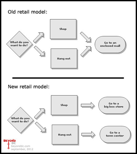
Thus Columbia Heights, combining the two.
Average Rating: 4.8 out of 5 based on 167 user reviews.
September 4th, 2012 | Permalink
Tags: economy, land use, urbandesign
|
Media


Site
About BeyondDC
Archive 2003-06
Contact
Category Tags:
Partners
|