|
Special Features


Image Libraries


|
|
Blog
Maryland has awarded a construction contract for the Langley Park transit center.
Langley Park is currently the busiest bus transfer location in the region that isn’t connected to a Metro station. But it’s a mess. Bus stops are spread all around the busy crossroads of New Hampshire Avenue and University Boulevard. Transit users hoping to transfer have to cross up to 14 lanes of traffic, and have to memorize which curbside bus stops their route uses. It’s a complicated and dangerous situation.
Solution: bus station.
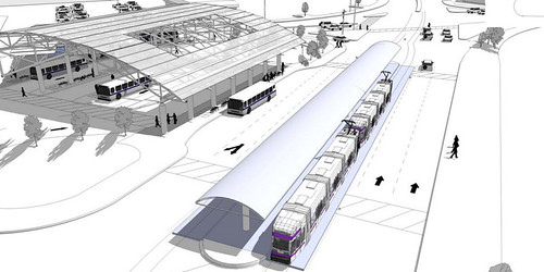
Langley Park transit center, including future Purple Line connection.
All images from Maryland MTA.
To solve this problem, Maryland has been planning for years to build a Langley Park bus station. The station would centralize all bus routes in the area under a single building, with vastly improved customer amenities.
Funding for the station was lined up in 2010 when MTA received a TIGER grant for it, but a land ownership issue delayed construction until now. Groundbreaking is expected this summer, with completion in fall of 2015.
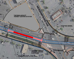
Location map. |
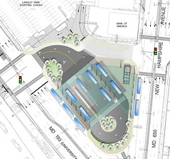
Transit center plan. |
Average Rating: 4.7 out of 5 based on 169 user reviews.
May 31st, 2013 | Permalink
Tags: bus, development, lightrail, transportation

Frequent transit maps highlight bus and rail lines that come at least every 15 minutes. They’re great tools that help riders easily identify the most convenient routes.
Such maps exist for more than 20 cities around the US, including DC. Stuart Sirota of TND Planning Group made this one, for Baltimore.
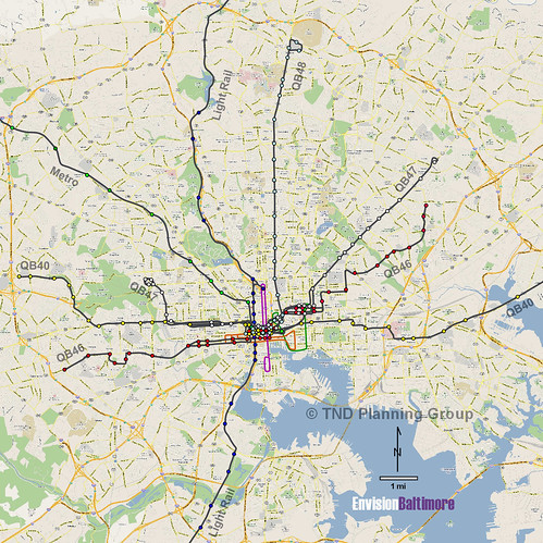
Baltimore frequent transit map, posted with permission from Stuart Sirota.
 Cross-posted at Greater Greater Washington. Cross-posted at Greater Greater Washington.
Average Rating: 4.8 out of 5 based on 264 user reviews.
May 29th, 2013 | Permalink
Tags: bus, lightrail, maps, metrorail, transportation
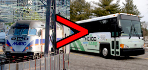
There was good news and bad news for Maryland transit yesterday.
The bad news was Maryland’s decision to cut bus service on the ICC. The good news was that the Purple Line, Corridor Cities Transitway, and Baltimore Red Line are all advancing, and that MARC’s Penn Line will start running on the weekend.
Overall, that’s a huge net gain for transit in Maryland.
The new BRT and light rail lines are still years away, but weekend MARC service could start as soon as this winter. The MARC news alone is a bigger win for transit than the ICC buses are a loss.
Not that there’s actually any trade here. MARC isn’t expanding service because ICC buses are going away. The two are unrelated. Just that, as a transit user, if I were given the choice between those two things, I’d definitely pick weekend MARC.
And although Maryland is deservedly criticized for the ICC, it’s also worth noting that the ICC is in the past, and the state’s current plans are extremely progressive.
Most of the new state’s new transportation money is going to transit instead of roads, and most of the road projects are relatively reasonable. There are plenty of proposed interchange improvements and widenings, but there’s no sprawl-inducing, traffic-generating outer beltway.
Average Rating: 4.6 out of 5 based on 168 user reviews.
May 17th, 2013 | Permalink
Tags: BRT, bus, commuterrail, lightrail, roads/cars, transportation
|
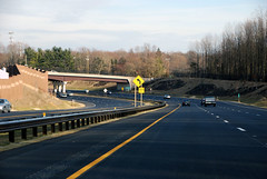
The ICC. |
Maryland may eliminate 3 of the 5 bus routes on the Intercounty Connector. The move is a classic bait and switch from highway builders: Get political buy-in with the promise of a multimodal road, then cut the multimodal aspects at the first opportunity.
The Maryland Transit Administration operates 5 bus routes on the ICC. They’re proposing to eliminate routes 202, 203, and 205. Only the 201 and 204 would remain, running from Gaithersburg to BWI and Frederick to College Park.
When planning the ICC, Maryland promised it would include good transit service and a high quality bike trail. They cut much of the trail in 2004. The bus service was never very good either, so it never got many riders. Now the state is citing that as a reason to cut it significantly.
Of course, cars aren’t held to the same standard.
There also aren’t many drivers on the ICC. Around 21, 000 cars per day use the road. The state says that meets projections, but the projections seem to change. At one point they were as high as 71, 000.
But is anyone proposing the state shut the road? Nope. Instead, the strategy is to try and boost car use.
Lawmakers hoped to induce more traffic with lower tolls last year, although that proposal was never accepted. This year the state raised the speed limit to make driving more attractive.
When it comes to bikes and transit, it’s cut and run at the first hint of a problem. For cars, it’s roll out the red carpet and hope for more traffic.
This isn’t the first time this has happened. When Virginia’s I-95 HOT lanes were first proposed, the firm hoping to expand the highway called its proposal “BRT/HOT lanes, ” but of course nothing resembling actual BRT was ever built.
Transportation advocates should remember this the next time someone proposes a “multimodal” highway. Odds are they won’t deliver.
Cross-posted at Greater Greater Washington.
Average Rating: 4.6 out of 5 based on 260 user reviews.
May 16th, 2013 | Permalink
Tags: bike, bus, roads/cars, transportation
|
Charlotte streetcar construction. Photo by Reconnecting America on flickr. |
President Obama yesterday nominated Charlotte Mayor Anthony Foxx as the next Secretary of Transportation. If Foxx’s experience in Charlotte is any indication, he’ll make a strong choice.
During his nomination press conference, Foxx said “cities have had no better friend” than the US Department of Transportation under outgoing Secretary Ray LaHood, and that if confirmed he would hope to “uphold the standards” LaHood set. That’s great news.
The fact that Foxx comes from a major central city is also a huge benefit. It means he understands urban needs, which aren’t just highways.
Charlotte may not be New York, but it’s made great strides in the right direction. The city’s first rail line opened a few years ago, and a streetcar line is under construction now. Charlotte also gained bronze-level status as a bike friendly community in 2008, and launched bikesharing in 2012.
Foxx has been a strong advocate for urban rail, especially streetcars. He knows transportation and land use are tied at the hip, and has fought repeated attacks on Charlotte’s streetcar by former Mayor and current North Carolina Governor Pat McCrory.
He’s also worked as an attorney for bus manufacturer DesignLine.
Foxx also knows that state Departments of Transportation can sometimes be part of the problem. At the federal level, it’s common for USDOT to delegate responsibilities and funding to state DOTs, under the assumption the states have a better understanding of local needs. But state DOTs aren’t any more local than any huge centralized government. And since they usually focus on highways, the result is that federal dollars mostly go to highways as well.
Since Foxx fought with the state over Charlotte’s streetcar, he knows that funneling everything through state DOTs means states hold the cards. He knows that can hurt cities.
Finally, Foxx hired Arlington, VA’s former county manager, Ron Carlee, to run Charlotte’s city government. Foxx would have heard about Arlington’s reputation for progressive transportation planning during the hiring process, and presumably counted it in Carlee’s favor.
Of course, no one can really predict what kind of Secretary Foxx will be. When progressive champion Ray LaHood was first tapped for the job, the blogosphere worried his history as a Republican from rural Illinois meant he’d be a status quo highway builder.
But we do know that Foxx has made a priority of building transit in his home city, and has had to fight to make it happen.
Cross-posted at Greater Greater Washington.
Average Rating: 5 out of 5 based on 174 user reviews.
April 30th, 2013 | Permalink
Tags: bus, government, lightrail, people, roads/cars, streetcar, transportation
|
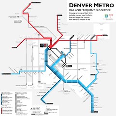
Denver frequent transit map, created by BeyondDC. |
Frequent transit maps specifically illustrate buses and trains that come at least every 15 minutes. They’re great tools that help people easily identify the most convenient routes. More and more transit agencies are publishing them. In other places, transit advocates are making their own.
Hopefully in the near future every transit agency will produce a frequent map as a matter of course. But for now they’re still pretty rare.
Wouldn’t it be great to have links to every one in the US and Canada? I think it would. So let’s make a list!
Here’s what I’ve got so far. Of the 42 US and Canadian urbanized areas above 1 million population, I’ve found 14 with frequent transit maps, including unofficial versions. I found several via the Human Transit blog, where Garrett Walker talks about them often.
Surely there are more. If you know of any I haven’t caught so far, leave a comment and I’ll edit the list.
> View the list.
Average Rating: 4.8 out of 5 based on 195 user reviews.
April 16th, 2013 | Permalink
Tags: bus, maps, transportation
Richmond has the bones of a good city. It’s small, with only a million people in its whole metro area, but it has a relatively large downtown and some very high quality urban neighborhoods. What it lacks is a transit system to match. The city’s new transportation plan aims to fix that.
Richmond’s bus system currently carries about 35, 000 riders per day, total, for the whole region. That’s about the same as the Fairfax County Connector, and less than half of the 90, 000 or so that Montgomery County’s Ride-On carries each day. Richmond could get so much more out of transit.
And now, it looks like they’re moving in that direction. The City of Richmond is drafting a new multimodal transportation plan. It builds on existing plans for a BRT line on Broad Street to propose a whole network of priority transit corridors. These would essentially be high quality surface bus routes, like WMATA’s 16th Street line. Not rapid, but not bad.
In addition to Broad Street BRT, the plan calls for 4 other priority bus lines, including one on the important Main Street / Cary Street corridor.
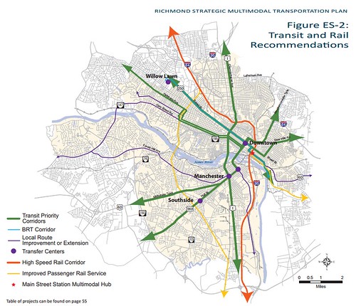
Richmond transit plan.
The draft plan also identifies bike improvements. Richmond is a natural biking city. It’s dense and walkable, and the urban areas are small enough that it’s easy to get to them all with a bike. Among proposed improvements, the plan calls for a bikesharing network, and identifies locations for cycle tracks.
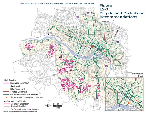
Richmond bike/ped plan.
Right now Richmond doesn’t have enough non-car transportation options. Even though the land use is already there to support multimodalism, most people rely on cars for most trips. Hopefully these proposals become reality, and transportation choice becomes more practical.
Cross-posted at Greater Greater Washington.
Average Rating: 4.8 out of 5 based on 214 user reviews.
April 10th, 2013 | Permalink
Tags: BRT, bus, master planning, transportation
Cool transit find of the week: This Capital Transit Company ticket from exactly 76 years ago, featuring robins and cherry blossoms.
For those keeping score at home, in 1937 it cost $1.25 for a week’s worth of unlimited streetcar and bus rides. Adjusted for inflation, that’s about $20. For comparison, WMATA weekly passes today go for $16 for a bus-only pass, and a little under $60 for a rail pass.
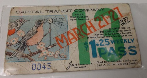
1937 Capital Transit ticket. Photo by u/stampepk on reddit.
Cross-posted at Greater Greater Washington.
Average Rating: 4.5 out of 5 based on 243 user reviews.
March 26th, 2013 | Permalink
Tags: bus, fun, history, streetcar, transportation
|
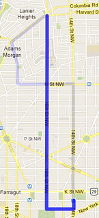
Selected route. |
WMATA has settled on a route for its new 16th Street short turn bus. The new service will run every 13 minutes from Harvard Street to downtown DC, from 7:30-9:15 am. It will begin on March 25.
The new route is intended to relieve extreme overcrowding on the southern portion of 16th Street during the morning rush.
Previously, WMATA had only considered running the route as far north as Meridian Hill Park. Metro bus planner Jim Hamre says that had been based on the assumption that only 2 buses would be available. Since 3 are actually available, they can go a little further north and maintain frequent enough service to make a difference.
The route will not be called the S3, as originally thought. It will simply be called the “S2 Short.” For riders on 16th Street, it will look like any other S2.
Hamre announced the new plan at last night’s Dupont Circle ANC meeting. Commissioner Kishan Putta, who organized earlier community meetings to push for the the change, then introduced a resolution of support, which the ANC approved.
Cross-posted at Greater Greater Washington.
Average Rating: 4.6 out of 5 based on 171 user reviews.
March 14th, 2013 | Permalink
Tags: bus, transportation
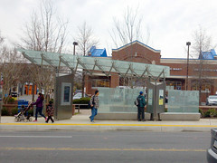
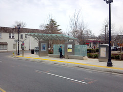
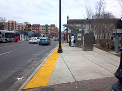
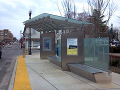
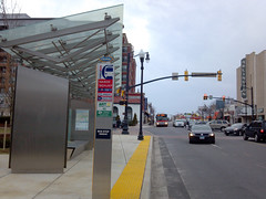
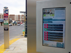
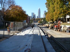
The best curbside bus stop in the region opened yesterday, at Columbia Pike and Walter Reed Drive in Arlington. The “super stop” has an expanded shelter area, a platform strip, maps, and an electronic real-time information screen. It’s the first of 24 planned super stops on Columbia Pike. When Arlington’s planned streetcar opens, the super stops will become rail stations, and off-board fare payment will be added.
Here are some quick photos.
Average Rating: 5 out of 5 based on 199 user reviews.
March 12th, 2013 | Permalink
Tags: bus, streetcar, transportation
|
Media


Site
About BeyondDC
Archive 2003-06
Contact
Category Tags:
Partners
|