|
Special Features


Image Libraries


|
|
Blog
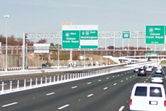
Simple plastic bollards and slight changes to lanes are enough to turn a regular bike lane into a cycletrack. Could the same trick work for bus lanes?
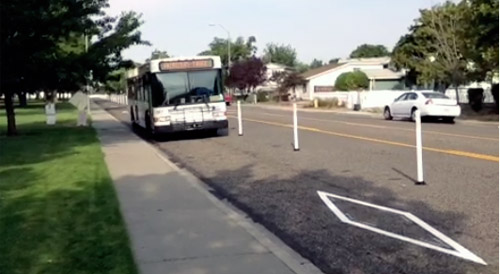
Bollard-protected bus lane in Washington state. Image from Zachary Ziegler on Vine.
DC’s 7th Street and 9th Street curbside bus lanes are famously dysfunctional. Cars use them at will, and pretty much always have. But it doesn’t have to be so.
The same tricks that work to protect bike lanes can also work to protect transit lanes. Plastic bollards, also known as flexposts, send a strong message to car drivers to stay out. The Virginia Department of Transportation even uses them on highways.
 |
 |
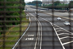
Flexposts on a Dulles Toll Road bus lane (left) and the Beltway (right).
Beltway photo from Google. |
Generally speaking, the same complications would exist for bus lanes as exist for cycletracks. Adding bollards takes up a couple of extra feet, parking for cars has to move a lane away from the curb, and you have to find a way to accommodate cars turning at intersections. But mixing zones and other clever solutions have solved those problems for cycletracks, and could work for bus lanes too.
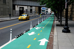
And flexposts aren’t the only cycletrack lesson we can apply to bus lanes. Red paint helps transit lanes the same way green paint helps bike lanes.
 |
 |
| Green means bike, red means transit. Bus lane photo from NYDOT. |
No matter how many special treatments like bollards or red paint an agency applies, median transitways will still function better than curbside transit lanes. Median transitways eliminate the right turn problem altogether (left turns are less common), and puts the transit lanes out of the way of parked cars, or cars pulling over to pick up or drop off passengers.
But median transitways take up more road space, because the medians have to be wide enough for stations. They simply can’t fit on all streets. Where that’s the case, tricks like these can help curbside transit lanes work better than the 7th Street bus lane.
 Cross-posted at Greater Greater Washington. Cross-posted at Greater Greater Washington.
Average Rating: 4.5 out of 5 based on 241 user reviews.
August 7th, 2014 | Permalink
Tags: bike, BRT, bus, lightrail, streetcar, transportation

DC has had a smattering of bike lanes since at least 1980, but the network only started to grow seriously starting in about 2002. This animation shows the growth of DC’s bike lane network, from 1980 through to 2012.
Animation from Betsy Emmons on MapStory.
From 1980 to 2001, literally nothing changed. Then in 2001, two short new bike lanes popped up. The next year there were 5 new ones. From then on, District workers added several new bike lanes each year, making a boom that’s still going on.
This animation ends in 2012, so it doesn’t include recent additions like the M Street cycletrack. But it’s still a fascinating look at how quickly things can change once officials decide to embrace an idea.
In a few years, a map showing the rise of protected bike lanes might start to look similar. That map would start in 2009 with DDOT’s installation of the original 15th Street cycletrack. It would expand slowly through this decade, then maybe (hopefully), it would boom as moveDC’s 70 mile cycletrack network becomes a reality.
Cross-posted at Greater Greater Washington.
Average Rating: 4.7 out of 5 based on 273 user reviews.
July 23rd, 2014 | Permalink
Tags: bike, maps, transportation
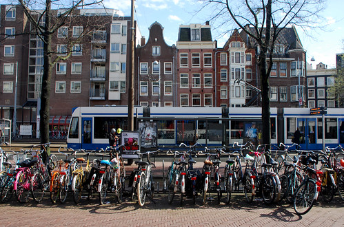
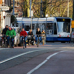
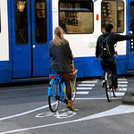
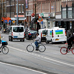
Despite the fact that streetcar tracks can be hazards to cyclists, bikes and streetcars are great allies.
They both help produce more livable, walkable, less car-dependent streets. It’s no coincidence that the same cities are often leaders in both categories. In the US, Portland has both the highest bike mode share and the largest modern streetcar network. In Europe, Amsterdam is even more impressive as both a streetcar city and a bike city.
With that in mind, here’s a collection of photos from Amsterdam showing bikes and streetcars living together.
Of course, it doesn’t just happen. It’s easy for bikes and streetcars in Amsterdam to avoid one another, and to interact safely, because each one has clearly delineated, high-quality infrastructure.
Chalk it up as one more reason to build good bike lanes.
Cross-posted at Greater Greater Washington.
Average Rating: 4.8 out of 5 based on 150 user reviews.
July 8th, 2014 | Permalink
Tags: bike, streetcar, transportation
As more cities build more protected bike lanes, some are beginning to use them as opportunities for public art. In Seattle, the new Broadway cycletrack includes a section with “art bollards.”
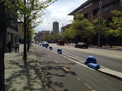
Seattle cycletrack. Photo by Gordon Werner on flickr.
Most cycletracks around the US use flexposts or concrete curbs to separate the bike lane from car traffic. A few use other methods like parking stops or zebras, but there are better-looking options available.
In addition to Seattle’s art bollards, a growing number of cities use landscaped barriers.
Vancouver cycletrack. Photo by Paul Kreuger on flickr.
These are great ideas. As cycletrack networks continue to expand, cities around the country can look for opportunities to make their bike lanes more beautiful.
But that being said, beautification adds time and expense to construction, and most cyclists would likely rank having more usable cycletracks sooner as a higher priority than art or landscaping.
So art is great, but there’s definitely a place for easy, cheap flexposts.
Cross-posted at Greater Greater Washington.
Average Rating: 5 out of 5 based on 201 user reviews.
June 16th, 2014 | Permalink
Tags: bike, transportation, urbandesign
The latest draft of DDOT’s citywide transportation plan, moveDC, calls for a massive expansion of transit and cycling facilities throughout the District, plus new tolls on car commuters. If the District adopts it, the plan will become one of America’s most progressive.

The moveDC plan summary map. All images from DDOT.
DDOT released the latest version of moveDC last Friday, launching a month long public comment period in anticipation of a DC Council hearing on June 27. Following that, the mayor will determine any changes based on the comment period, with final adoption anticipated this summer.
What’s in the plan
Amid the hundreds of specific recommendations in the plan, three major proposed initiatives stand out:
- A vastly improved transit network, with 69 miles of streetcars, transit lanes, and improved buses, plus a new Metrorail subway downtown.
- A massive increase in new cycling infrastructure, including the densest network of cycletracks this side of Europe.
- Congestion pricing for cars entering downtown, and traveling on some of DC’s biggest highways.
Transit

Proposed high-capacity transit network (both streetcars and bus). Blue is mixed-traffic, red is dedicated transit lanes.
The plan proposes to finish DC’s 22-mile streetcar system, then implement a further 47-mile high-capacity transit network that could use a combination of streetcars or buses. That includes 25 miles of dedicated transit lanes, including the much requested 16th Street bus lane.
Although the proposed high capacity transit corridors closely mirror the 37-mile streetcar network originally charted in 2010, there are several new corridors. In addition to 16th Street, moveDC shows routes on Wisconsin Avenue, both North and South Capitol Streets, H and I Streets downtown, and several tweaks and extensions to other corridors.
The plan endorses WMATA’s idea for a new loop subway through downtown DC, but explicitly denies that DC can fund that project alone.
MoveDC also shows a network of new high-frequency local bus routes, including Connecticut Avenue, Military Road, Alabama Avenue, and MacArthur Boulevard.
Bicycles
MoveDC also includes a huge expansion of trails and bike lanes, especially cycletracks.

Proposed bike network. The pink lines are cycletracks.
Under the plan, DC would have a whopping 72 miles of cycletracks crisscrossing all over the city. From South Dakota Avenue to Arizona Avenue to Mississippi Avenue, everybody gets a cycletrack.
Meanwhile, moveDC shows major new off-street trails along Massachusetts Avenue, New York Avenue, and the Anacostia Freeway, among others.
Tolls for cars
Congestion pricing is clearly on DDOT’s mind, with multiple proposals for new variable tolls in the plan.

Proposed downtown cordon charge zone.
The most aggressive proposal is to a declare a cordon charge to enter downtown in a car. This idea has worked in London and has been discussed in New York and San Francisco, but so far no American city has tried it.
Meanwhile, some of the major car routes into DC would also be converted to managed lanes. Like Maryland’s ICC or Virginia’s Beltway HOT lanes, managed lanes have variable tolls that rise or fall based on how busy a road is.
MoveDC proposes managed lanes on I-395, I-295, New York Avenue, and Canal Road.
What will the council think?
DDOT has produced a very strong plan, but is it going anywhere? The DC Council will discuss moveDC on June 27, at which time we’ll find out if the same people who pulled the rug out from under streetcar funding are interested in progressive policy-making, at least.
Even if DC does adopt this plan, whether the council will actually provide the funds necessary to build it is anybody’s guess.
Correction: An earlier version of this story reported the DC Council will approve or deny this plan. Authority to approve it actually rests solely with the mayor.
Cross-posted at Greater Greater Washington.
Average Rating: 4.7 out of 5 based on 229 user reviews.
June 2nd, 2014 | Permalink
Tags: bike, BRT, bus, government, lightrail, master planning, metrorail, roads/cars, streetcar, transportation
With DC’s M Street and 1st Street cycletracks on the ground, the central city network of protected bike lanes is starting to actually look like a network.
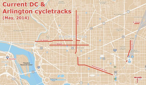
Base map from Google.
This map shows every cycletrack in town. In addition to M Street and 1st Street, there’s L Street, Pennsylvania Avenue, good old reliable 15th Street, and the diminutive R Street lane near the Metropolitan Branch Trail.
For the sake of completion the map also shows Rosslyn’s super tiny cycletrack, which exists mainly to access a popular Capital Bikeshare station.
Between DC’s proposed 70 mile cycltrack network and plans coming together in South Arlington, hopefully future iterations of this map will look even better.
Notice anything missing or wrong?
Average Rating: 4.9 out of 5 based on 280 user reviews.
May 21st, 2014 | Permalink
Tags: bike, maps, transportation, Uncategorized
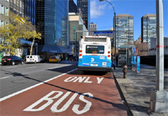
DC is adding green-painted bike lanes left and right, which is great news, but the District is way behind other cities in another type of painted pavement that’s beginning to sweep across America: red-painted bus lanes.
|
 |
Red-painted bus lanes in New York (left) and San Francisco (right).
Photos from NYDOT and Reddit user freedenizen. |
The idea behind red-painted bus lanes is exactly the same as green for bikes. It’s a clear signal for car drivers to stay out, so there’s no excuse for illegally driving in a non-car lane. San Francisco even uses dashed red paint to indicate where cars are allowed to cross bus lanes, exactly how DC uses green dashes for crossings.
In addition to New York and San Francisco, red-painted bus lanes will also soon pop in Seattle and Chicago.
Why not here? For one, obviously, DC doesn’t have many bus lanes. Plans for bus lanes on 16th Street and H & I Streets are stalled, and although the K Street Transitway is moving forward as part of the crosstown streetcar, there’s no opening date in sight.
But DC does have one bus lane on the ground right now that could benefit from red paint. 7th Street NW in Chinatown, directly in front of the Verizon Center. 7th Street has signs and pavement markings indicating it’s a bus lane, but it’s never enforced, and so many cars use the lane that you’d never know they’re not supposed to be there.
If DDOT is serious about keeping the 7th Street bus lane then red paint could be a way to make it work. If not, paint is still worth exploring on 16th, H & I, and K, if bus lanes there ever actually happen.
Average Rating: 4.4 out of 5 based on 292 user reviews.
May 15th, 2014 | Permalink
Tags: bike, BRT, bus, transportation
A global cycling heat map from the fitness app Strava shows where people are exercising by bike. It’s a useful tool to chart the most popular bike trails, but the data skew heavily towards wealthier recreational cyclists and away from transportation and less affluent areas.
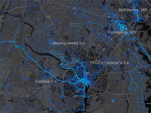
Stava cycling heat map for the DC region.
Strava is an exercise app for smartphones that uses GPS to track users’ cycling and jogging routes. Fitness enthusiasts use it to chart their running or cycling times, and measure performance over time. Since the company has billions of data points from users all over the world, it was easy to plot it all onto a map.
The resulting global heat map is a fascinating look at the most popular trails. For our region, it’s easy to see long-distance regional trails stand out, especially in Fairfax, Arlington, Montgomery, and Howard Counties.
But while this is interesting stuff, it’s unfortunately not very useful for urban transportation planning. Since 100% of Strava users care so much about speed that they’ve downloaded an app to measure it, and are wealthy enough to have a smartphone, the data skews seriously in favor of recreational cycling among affluent populations.
On the flip side, it seriously undercounts cyclists who bike as transportation simply to get from point A to point B. Likewise, it seriously undercounts lower income populations.
To prove the point, merely compare the trails on the west side of the DC region to those on the east side. Or compare the bright blue suburban trail network in Columbia, MD with the much more limited cycling apparent in central Baltimore. The places affluent people bike on the weekend stand out, while others sink to the background.
So this is neat info, beautifully presented, with practical applications to regional trail planning and parks planning. But for urban bike lanes, it’s no substitute for hard local data.
Cross-posted at Greater Greater Washington.
Average Rating: 4.7 out of 5 based on 231 user reviews.
May 12th, 2014 | Permalink
Tags: bike, maps, transportation
Arlington is deploying bike “fix-it” repair and maintenance stands at Metro stations around the county. The stands include all the tools cyclists need to change a flat tire, add air, or adjust brakes and derailleurs. Just hang your bike on the kiosk and go to work, free of charge.
So far there are stands at the bike parking stations in Clarendon and Ballston. Watch for one soon in Pentagon City.
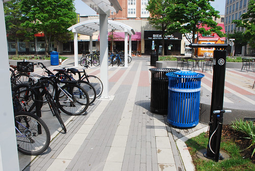
Clarendon bike fix-it stand, on the right.
Cross-posted at Greater Greater Washington.
Average Rating: 4.5 out of 5 based on 238 user reviews.
May 9th, 2014 | Permalink
Tags: bike, transportation
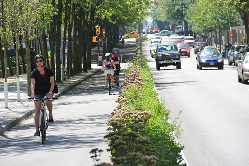
Take a look at this cycletrack in Boulder, CO. It includes parking stops along with the usual flexposts, thus providing strong protection against cars.
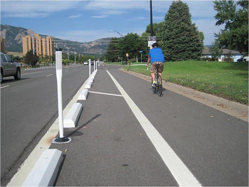
Baseline Road cycletrack, Boulder, CO. Photo from the City of Boulder.
This particular cycletrack is on Baseline Road, a busy suburban arterial with relatively high-speed car traffic. It’s easy to understand why cyclists would want more protection there than on a slower-speed urban street.
This design is a stark contrast from the more urban cycletrack in downtown Boulder, where a lush (and expensive) landscaped median provides the protection from cars.
Between the two designs, one can see the range of options.
13th Street cycletrack, Boulder, CO. Photo from BeyondDC.
Cross-posted at Greater Greater Washington.
Average Rating: 4.7 out of 5 based on 280 user reviews.
May 7th, 2014 | Permalink
Tags: bike, transportation
|
Media


Site
About BeyondDC
Archive 2003-06
Contact
Category Tags:
Partners
|