|
Special Features


Image Libraries


|
|
Blog
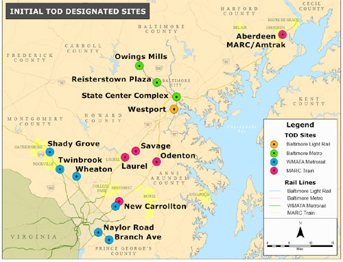
Maryland governor Martin O’Malley designated the following locations as official state-government-supported Transit Oriented Developments. Essentially, official designation targets these areas for state funding, and makes it easier for locals to raise new funds of their own.
Average Rating: 5 out of 5 based on 192 user reviews.
June 18th, 2010 | Permalink
Tags: government, metrorail, transportation

Today’s Washington Post features a cautionary tale of real estate greed, in which the owner of a Massachusetts Avenue building who wanted to cash in by selling to developers demanded such outrageous prices that the suitors dried up and built around him, rather than deal.
Yes that’s right, the greedy party in the story wasn’t the developer.
While I think the Post is right on in laying the blame for this missed opportunity at wealth on the feet of the building’s existing owner, whose poor treatment of the site makes it obvious he has no great love for the community (there’s no sidewalk out front, just a patch of dirt), the story also illustrates something extremely unfortunate about contemporary development.
No, I’m not talking about the fact that larger-scale redevelopment happens. This is Massachusetts-freaking-Avenue, right in downtown Washington; it is wholly appropriate that redevelopment happen here. Indeed, there is no better place.
Here is the bit of the story to which I object:
Jackson Prentice, a broker who on behalf of the Trammell Crow development company said … “Once they build around you, you’re done.”
…
Other developers say: The parcel, at nearly 1, 800 square feet, is too small to accommodate underground parking.
In other words, a perfectly good piece of downtown property is unusable because – the horror – it’s too small for its own parking garage.
Excuse me, but I know some developers who might disagree. If they can build a 42-story condo building in Toronto without a parking garage, then somebody can surely use a little lot in downtown Washington for something. Dedicated parking is not now and never was a necessary component of redevelopment. Some redevelopment needs it, sure, but not all redevelopment. In fact, the city of Washington is absolutely full of buildings that don’t have dedicated parking, not all of them from the 19th Century.
This lot sits at a fantastic location, directly fronting on one of downtown’s most important avenues. Yes, its owner was wrong to hold out for unreasonable amounts of money, and yes, it would have been more valuable as part of a larger redevelopment scenario, but considering this lot to be unusable because it’s small is just flat out wrong. We can build tall, narrow buildings in this city. Eventually, somebody will do that here.
Average Rating: 4.7 out of 5 based on 239 user reviews.
June 18th, 2010 | Permalink
Tags: development, preservation, urbandesign
The nifty computer model of Dupont that GGW featured yesterday reminded me of an email I received earlier this week pointing me towards an equally cool model of Rosslyn that DC Metrocentric reported on last year.
The three tallest buildings in the center of the model (the two with the sloped roofs and the one with the pyramid) are under construction now.

For more, check out the original DC Metrocentric thread.
Average Rating: 4.7 out of 5 based on 161 user reviews.
June 18th, 2010 | Permalink
Tags: development, fun, galleries
The good news: Amtrak will soon start a new line to Norfolk, meaning passengers to the Hampton Roads area will no longer have to trek across the James River to Newport News to catch a train. Hooray!
The bad news: The train won’t actually stop in either downtown Norfolk nor downtown Richmond, by far the two largest walkable and transit-friendly destinations in Virgina outside the DC area.
Although Amtrak operates a gorgeous station in downtown Richmond, it’s more expensive for trains to stop there, so only a handful do. Instead, most Richmond trains stop at Staples Mill Station, a shack in the middle of an industrial park, miles from anything walkable.
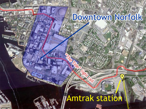
The Norfolk situation is better. The proposed station, at Harbor Park, is almost downtown, and although it’s more or less impossible to walk, at least there will be a handy light rail connection. Imperfect, but far preferable to what you get in Richmond if you have to stop at Staples Mill.
Here are a couple of maps to illustrate what’s going on.
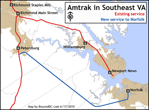 
Both maps by BeyondDC. Click to enlarge.
Average Rating: 4.9 out of 5 based on 244 user reviews.
June 17th, 2010 | Permalink
Tags: intercity, transportation
The latest Cool Thing sweeping the net is this mapping website that shows domestic county-to-county migration patterns during 2008. That is, it shows you where people in the US moved to and from that year.
Click on any county in the United States and the map will display lines indicating where residents of that county moved to or from. Black lines indicate net inward movement (people moving into the county), red lines net outward movement (people moving out of it).
Some interesting results are below.
The District of Columbia:
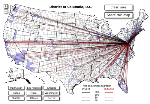
A lot more black than red is good news; it means more people are moving in than out. Geographically the ins and outs are fairly evenly distributed, although it’s clear enough that more people are coming from the north and leaving for the south and west.
DC area suburbs:
From left to right, Montgomery County, Prince William County, Arlington County.
 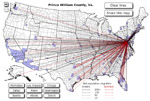 
Interesting that from the perspective of black-to-red ratio, inner suburb Arlington is doing a whole lot better than outer suburb Prince William, with relatively comparable numbers of movements. Montgomery’s map is denser with both red and black, it being such a larger jurisdiction, but it is clear that even wealthy MoCo isn’t doing as well as the District.
Other cities:
From left to right, Los Angeles, Houston, and Cumberland, MD.
  
Except for a solid influx from the northeast, LA is bleeding just about everywhere; is it time to start calling what’s going on the California diaspora? The map for Houston on the other hand is a mirror-image, covered in oily black. Smaller cities and rural areas obviously have less movement of both sorts, but isn’t it interesting that long-suffering Cumberland has as much black as red, and that its population gains are coming from the very suburban areas that were responsible for draining it in past decades?
This is yet more proof that the 20th Century model of municipal winners and losers is becoming increasingly obsolete. The south still grows at the north’s expense, but California isn’t paradise any longer. Meanwhile, central cities and an increasing number of small towns are more than holding their own against sprawl.
There are no two ways about it: The 21st Century is going to be different than the 20th.
 Cross-posted at Greater Greater Washington. Cross-posted at Greater Greater Washington.

A modified version of this post appeared on the Washington Post Local Blogging Network.
Average Rating: 4.7 out of 5 based on 152 user reviews.
June 16th, 2010 | Permalink
Tags: The New America
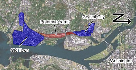
Alexandria has approved a rezoning for Potomac Yard that will, over time, convert what is probably the largest strip mall inside the Beltway into a bona fide mixed use urban neighborhood. Along with the Arlington portion, redevelopment in Potomac Yard will finally stitch together the walkable nodes of Crystal City and Old Town Alexandria into one continuous 5-mile long corridor of urbanity.
By just about any measure, this new conglomeration will be the largest mass of walkable urbanism in the region, after central DC.
A complete 5-mile-long urban corridor
Average Rating: 4.8 out of 5 based on 269 user reviews.
June 15th, 2010 | Permalink
Tags: master planning, urbandesign
|
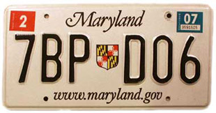
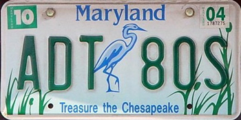
Old and busted.

New hotness?
Photo of existing plate from StateSymbolsUSA. New plate image courtesy MD MVA. |
Starting today Maryland has a new basic license plate. People registering cars in the state will from now on receive the red and blue 1812 design (bottom right), rather than the now-retired black and white design (top right).
The bad news is whoa that’s an ugly license plate. The clip-art look wasn’t cool in the 90s and certainly isn’t cool now, and the best thing that can be said about that font is at least it’s not comic sans. The feedback in Dr. Gridlock’s poll on the subject is almost universally negative.
The good news is that hey, it’s only a license plate. What does it really matter? Also, in 5 years the state will retire this design and start over. Apparently they’re just doing it to mark the 200th anniversary of the War of 1812, and will cease issuing the plates in 2015.
My advice to the Motor Vehicle Administration: Bring back the person who designed the original Chesapeake Bay plate. Now that was an attractive piece of metal.
Average Rating: 4.8 out of 5 based on 188 user reviews.
June 14th, 2010 | Permalink
Tags: roads/cars, transportation
As Arlington County prepares a redevelopment plan for East Falls Church, the City of Falls Church is considering its own options. One possibility is to use Four Mile Run as the centerpiece of an East Falls Church Waterfront District.
Yes that’s right, a waterfront district. Falls Church may be 6 miles from the Potomac, but why let that stop them?
The waterfront plan was prepared by Virginia Tech students as an academic exercise, but the idea so intrigued Falls Church city leaders that they are seriously considering it as a vision for future planning.
The idea is to redevelop the low-density industrial block between West Jefferson Street and Four Mile Run (see map) as a series of mid-rise mixed-use buildings, with a park along the side of the creek.
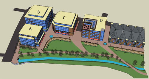
Rendering of a possible East Falls Church waterfront at Four Mile Run
In truth, it will take years for the City of agree to a plan, convince the landowners, find a developer, get financing, and construct the project. This is an idea, not an action proposal. But it’s a really good idea that seems to have legs. It meshes well with other likely redevelopment around the East Falls Church Metro, and could in the long term be a real winner.
It’s definitely something to keep an eye on.
Cross-posted at Greater Greater Washington.
Average Rating: 4.4 out of 5 based on 198 user reviews.
June 11th, 2010 | Permalink
Tags: master planning, proposal
Glover Park ANC 3B will be taking up a resolution supporting streetcars at its meeting tonight. Local residents may find the meeting interesting, and may want to consider speaking in support.
Average Rating: 4.4 out of 5 based on 266 user reviews.
June 10th, 2010 | Permalink
Tags: events, streetcar, transportation
In a post at the Washington Post Local Blogging Network, I discuss why it is foolish to suggest that the District should divert money from infrastructure to social services, because infrastructure is an investment that pays off in terms of economic development, which in turn simultaneously reduces the need for social services while providing the city with the money it needs to pay for them.
Average Rating: 4.6 out of 5 based on 229 user reviews.
June 9th, 2010 | Permalink
Tags: economy, social, streetcar, transportation, washpostblog
|
Media


Site
About BeyondDC
Archive 2003-06
Contact
Category Tags:
Partners
|


