|
Special Features


Image Libraries


|
|
Blog
Earlier this week the Montgomery County Council rejected a proposal to build the Purple line with only one track. In today’s installment of the Washington Post Local Blogging Network I explain why single tracking is a bad idea, and laud the Council for making the right decision in endorsing a double track.
Average Rating: 4.6 out of 5 based on 151 user reviews.
July 30th, 2010 | Permalink
Tags: lightrail, transportation, washpostblog

Does BeyondDC look a little weird today? I switched the left and right columns, so that “Features” and “Site” are now on the left, and “Twitter” and “Photos” are now on the right.
This should make the site load quite a bit faster. Locating the Twitter feed before the main blog content was slowing things down.
Average Rating: 4.5 out of 5 based on 221 user reviews.
July 30th, 2010 | Permalink
Tags: site
Clarification: Please note that the “Newsfeed” is NOT the RSS feed for the regular BeyondDC blog. The Newsfeed was a totally separate publication that passed on news headlines without comment. You can see what it looked like here. The main BeyondDC blog will continue to feature the same sort of articles it always has, and will continue to be syndicated via RSS. Apologies for any confusion. My fault for not better explaining the difference.
Despite the poll in January that showed support to keep the Newsfeed, I am finding that it is increasingly difficult to keep it up. Twitter is easier to maintain and is regularly followed by about 10 times more readers than the Newsfeed. Between that and GGW’s Breakfast links (which often cover the same stories) the Newsfeed is simply obsolete.
So it will be shut down in favor of an increased presence on Twitter.
But don’t fret if you’re not a fan of Twitter. You don’t have to join to read. In fact, you can use Twitter almost exactly the same way you currently use the Newsfeed.
Readers using RSS can syndicate BeyondDC’s Twitter feed into their aggregator. If you’re one of the 54% of Newsfeed readers who accessed it via RSS, just replace the old feed URL with the this one and you will barely notice a difference.
Readers used to visiting the Newsfeed home page can simply visit BeyondDC’s Twitter profile, which is nothing but a list of BeyondDC messages, exactly like the Newsfeed home page.
I’m sorry to disrupt folks who liked things the old way, but the Newsfeed has always been problematic, and at some point there’s just too much duplication of content for it to be worth my time to keep up.
Average Rating: 4.4 out of 5 based on 175 user reviews.
July 30th, 2010 | Permalink
Tags: site
Friend of BeyondDC Craftgasm snapped this cell phone picture just minutes ago while walking by the Scottish Rite of Freemasonry Temple on 16th Street, where DDOT photographers were reviewing the very first Capital Bikeshare bike.
DDOT’s representative says this bike arrived earlier today. Presumably they’ll be making higher quality pictures available soon.
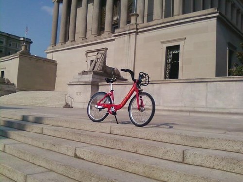
Do want.
Average Rating: 4.6 out of 5 based on 207 user reviews.
July 28th, 2010 | Permalink
Tags: bike, events, galleries, transportation
14th Street in Columbia Heights has been torn to shreds since, oh, approximately the Paleozoic Era. Could it finally be finished?
DDOT posted this picture to its Facebook profile this afternoon, with the caption “We know the construction has been challenging, but here is what has emerged from beneath the paving equipment and traffic cones: a new Columbia Heights with a truly unique streetscape…”
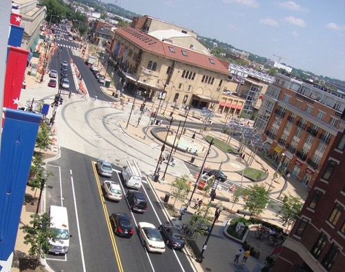
The plaza at 14th Street and Park Road, Columbia Heights.
Image from DDOT.
Average Rating: 4.8 out of 5 based on 280 user reviews.
July 28th, 2010 | Permalink
Tags: development, roads/cars, transportation
|
Vermont Avenue’s new “road tattoo”. Photo by DDOT. |
Vermont Avenue between H and I Streets is an unusual place. It’s so underused as a traffic thoroughfare and such a prestigious location close to the White House that it is becoming clear it may be better suited to a life as something other than a mere street.
Not only is this block of Vermont the very last block of the street, it’s an orphan – a segment disconnected from the main stretch of the road, and therefore used very sparingly by drivers. So sparingly in fact that when it closes for a farmer’s market once a week at the height of rush hour there is no noticeable effect on congestion. Even when this block is open to traffic it is clear that there’s a surplus of available street space, given that it has pavement-hogging diagonal on-street parking, something typical in small towns but rarely available in more crowded big cities.
In fact, DDOT has even said it is considering closing the block more often for special events like concerts, in addition to the farmer’s market (link is a pdf – see bottom of page 1 under “Regulatory”).
On the other hand, Vermont’s orphan block is tucked so nicely between McPherson and Lafayette Squares that it almost feels like a park itself, especially when it’s closed for that rush hour farmer’s market. And as of this weekend, the city has installed a so-called road tattoo – an installation of pavement art that makes the space seem even less like a normal street and more a public plaza.
Given the situation, should this block even be a street? Would it make more sense to close it off and call it a park? Or maybe go halfway and continue to allow cars, but in a redesigned space? Or maybe this block is so valuable precisely because it’s a street rather than another park square, and we should leave well enough alone.
The great thing about the world of urbanist blogging is that we can ask these questions, and get an educated, insightful discussion going. So what do you think? Convert this block to a full-time park? Leave it a street but program things differently? Leave it be? If you think it ought to change, what’s the ideal solution?
 Cross-posted at Greater Greater Washington. Cross-posted at Greater Greater Washington.
Average Rating: 4.5 out of 5 based on 159 user reviews.
July 27th, 2010 | Permalink
Tags: proposal, urbandesign
|
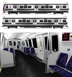
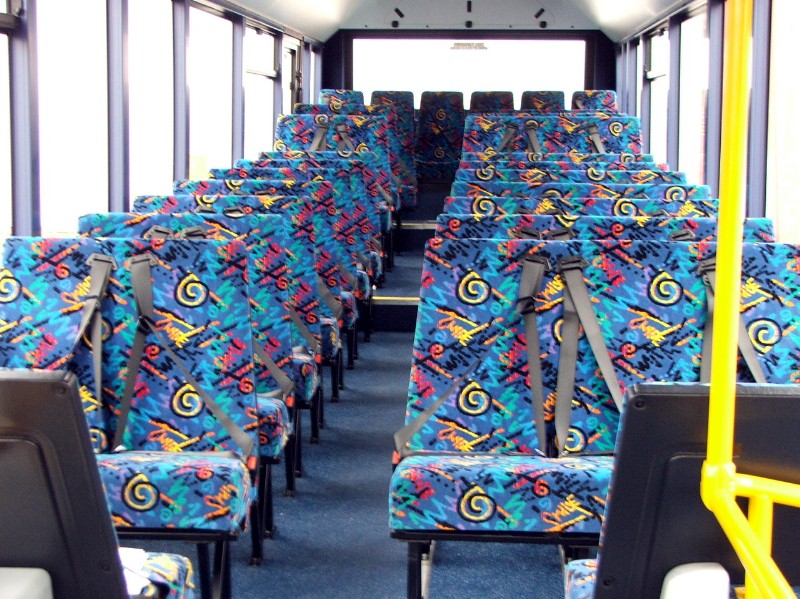
WMATA’s new railcars will be visibly different from all others. |
Greater Greater Washington has a post up today discussing capacity and safety issues with WMATA’s new order of Metro railcars. In the post, GGW links to a WMATA report on the design and layout of the railcars. BeyondDC has looked at this before, but now that things are getting close to final, it’s worth another quick review.
First off, the exterior: I’m a big fan. I know there are some people out there who love the brown paneling on the side of Metro’s existing cars, but personally I find it ugly and am happy to be rid of it. The all-steel look is classic and no-nonsense. It looks like a bona fide subway car, which somehow makes it seem more legitimate. At least to me.
Inside, all remaining traces of the old orange-tone design have likewise been redesigned. The rubber flooring and less expensive seat padding seem like reasonable measures. The layout of poles is clearly designed to draw passengers away from the doors and into the aisle, which will be a welcome change come tourist season. I would have liked to see longitudinal seating, as GGW discusses, but well, can’t win them all.
My only other complaint is the choice of seat fabric. Is there some rule that says transit seats can’t be a solid color? Some APTA national standard that seat fabrics must look like they’re from Saved By The Bell? Honestly, every time I see seats with those damn neon squigglies (technical term), I want to puke. Could we please just have a solid color? Or, if not, at least something simple and dignified?
Average Rating: 4.5 out of 5 based on 235 user reviews.
July 22nd, 2010 | Permalink
Tags: metrorail, transportation
|
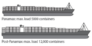
Much larger ships will soon be able to sail through Panama, increasing traffic at east coast ports. |
I live-tweet the monthly meeting of the Transportation Planning Board. This month there were a number of items that I think folks might like to see in more-than-140-character detail:
- The Board reviewed and accepted the first-ever National Capital Region Freight Plan (pdf), which discusses rail and trucking issues in the region. When the Panama Canal expansion project is completed in 2015, it will dramatically expand the tonnage of material shipped to east coast ports from Asia, which in turn means the amount of freight carried inland from ports like Norfolk and Baltimore will dramatically expand as well. To deal with this expected increase and still accommodate passenger rail, regional rail providers are working to expand their capacity any way they can. These strategies are discussed in the report.
- Each year the TPB provides a series of planning grants to local jurisdictions aimed at improving the connection between transportation and land use. This year the Board approved 8 projects (pdf), listed below:
- Van Ness Metro access and commercial corridor enhancement
- Best practices in providing concurrent bicycle and streetcar facilities in the same corridor
- Pedestrian facility standards for mixed-use developments in Prince William County
- Integrating freight rail with other land uses in Frederick
- Potential TOD scenarios for the US 29 / Cherry Hill area of Montgomery County
- Prince George’s County Central Avenue TOD scenarios
- Naylor Road Metro accessibility
- Safe walkways to transit in Rockville
- The Board received a briefing about the state of the commute survey (pdf), a study of commuting trends in the DC area. The survey presentation includes a lot of interesting information and is worth skimming. I’ve republished one page from it below. The implication that transit mode share is rising regionally is certainly a very significant piece of information.
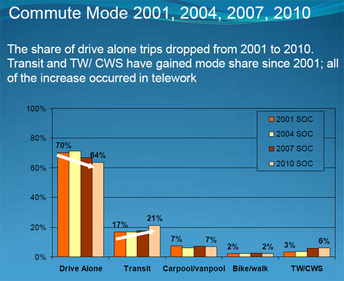
Regional commuter mode share over time.
Click the image to download the presentation.
Average Rating: 4.6 out of 5 based on 231 user reviews.
July 21st, 2010 | Permalink
Tags: environment, master planning, The New America, transportation
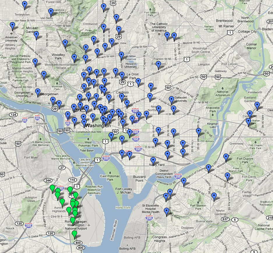
I combined the DC bikeshare map just released with the Arlington map released a few days ago to create this single regional system map.
No new info, just handy.
Unfortunately, I am not sure how to export the combined version as a single link, so all you get is a screencap, but you can combine the two yourself by simply checking them both to “on” in the “My Maps” section of Google Maps.

Click the map for a larger version (still a screencap).
Average Rating: 4.6 out of 5 based on 292 user reviews.
July 20th, 2010 | Permalink
Tags: bike, fun, transportation
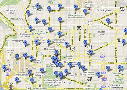
The news is already all over the internet, but this is one of those stories that BeyondDC just has to cover: The first 100 DC locations for Capital Bikeshare stations were announced today by DDOT. They join the initial set of Arlington stations announced a few days ago.
There are stations in all eight wards, but the biggest cluster is in the central city. Here’s a map:
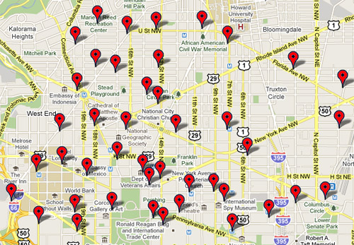
Corrected map of Capital Bikeshare stations in central DC.
For the preliminary version that was slightly different, click here.
One thing I notice is that there’s no station at Farragut Square. That seems like a major omission, but otherwise the spread seems to be pretty good. I get a station less than a block from my home.
In related news, the official Capital Bikeshare website is now live, although for the time being there isn’t much content.
Update #1: The Google Maps version now shows a station at Farragut Square. Not sure whether it was always supposed to be there, or was moved this morning. Maybe BeyondDC’s tweet did the trick (probably not). ~ 11:45 a.m.
Update #2: The original map was apparently a preliminary version. DDOT will be making an official announcement and posting the corrected final map later today. GGW has the scoop. – 12:24 p.m.
Update #3: DDOT has posted the corrected map. I’ve edited the above post to include the correct version. – 4:30 p.m.
Average Rating: 4.7 out of 5 based on 219 user reviews.
July 20th, 2010 | Permalink
Tags: bike, galleries, transportation
|
Media


Site
About BeyondDC
Archive 2003-06
Contact
Category Tags:
Partners
|


