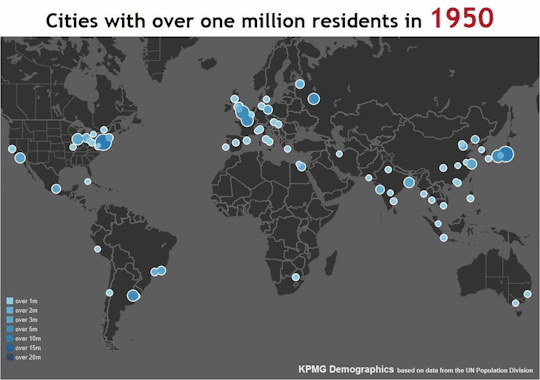
The number of urban areas in the world with a population over one million has exploded since 1950. This map shows just how extreme that explosion has been.
Image from KPMG.
On the map, you can see how in 1950 the world’s scant million-plus cities were heavily concentrated in western Europe, the northeastern United States, and Japan. Since then, not many new ones have popped up in those places, but the rest of the world has caught up big time.
By the 1980s, China, India, and southeast Asia are challenging the west’s dominance. By the turn of the millenium, the middle east and central Africa join the party. South America keeps up a slower but steady pace the whole time.
While H Street NE has boomed in recent years, nearby Benning Road has lagged. That’s about to change, with at least two big Benning Road redevelopments coming down the pipeline.
The proposal at 17th and Benning. Image from Capital City Real Estate.
Benning Road NE is, for all intents and purposes, an easterly extension of H Street. East of Starburst the name changes, but Benning more or less functions as the same road, streetcar and all. Except that while H Street has undergone a dramatic transformation in recent years, Benning Road has not.
But now it appears the H Street boom is jumping to Benning.
On December 17, developers officially filed plans to build a 180-unit multifamily building at the northeast corner of Benning Road and 17th Street NE, across 17th Street from Hechinger Mall.
It’s the first big, H Street-style proposal to see the light of day on Benning Road.
But it’s not the only one. Half a block away and across the street, near 16th and Benning, another developer is proposing a 250-unit building. There are no renderings yet, but rumor purports it will be similar to The Maryland at Maryland Avenue and 14th Street NE.
Together, these developments show how the impending Benning Road boom isn’t a matter of if, it’s a matter of when. Properties along Benning are too enticing, demand for new housing in DC is too ravenous, and the streetcar, for all its faults, is too much of a draw. Benning is about to boom, and it won’t be the same.
Part of the appeal of the cultural juggernaut that is Star Wars has always been its fantastic settings, including its cities. As The Force Awakens arrives in theaters today, here are the five most fascinating cities from the six previous live-action Star Wars movies.
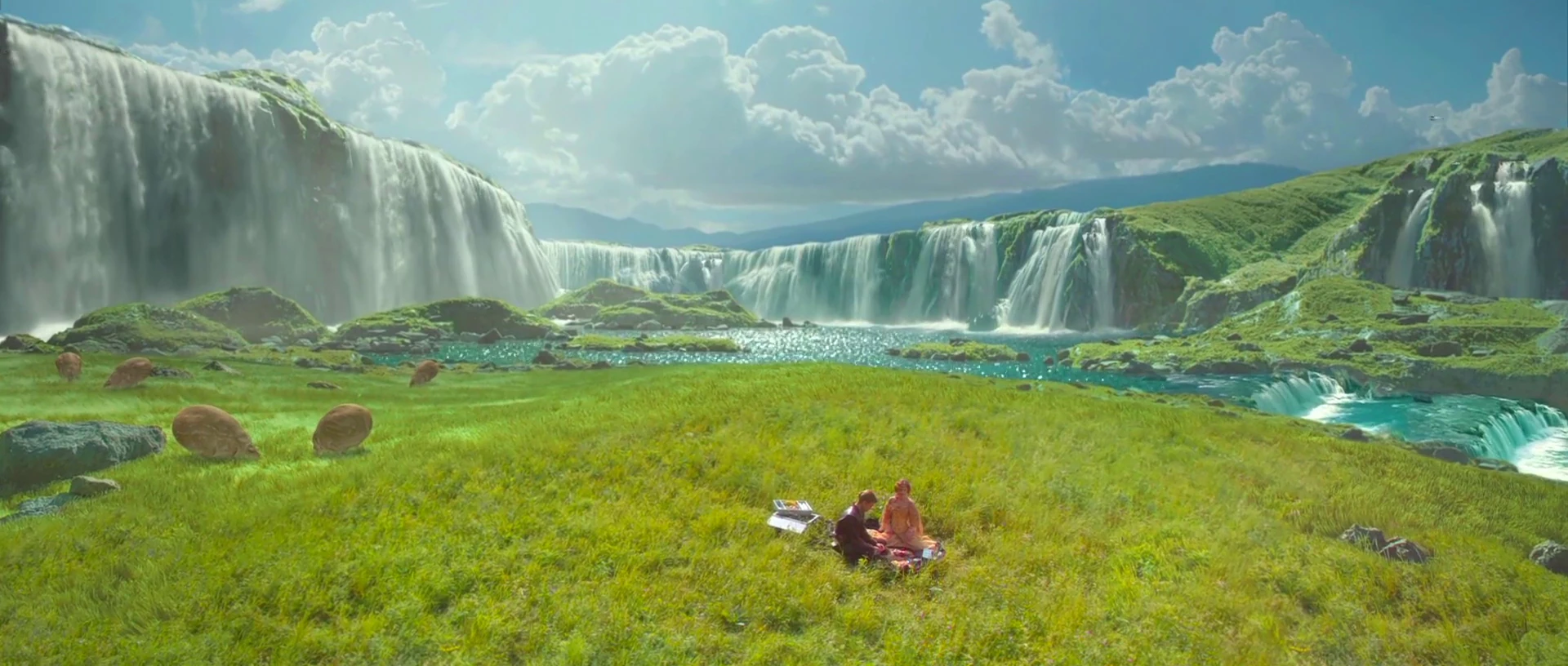
5. Theed
Theed. Image from Star Wars.
The Phantom Menace may have been a disaster of a movie, but its setting at the height of the galaxy’s pre-Empire luxury showed us a strong contender for the most beautiful city in the franchise. Theed is Queen Amidala’s home, and capital of the planet Naboo.
Picturesque Naboo is the Neoclassical Europe of the Star Wars universe. Its ornate buildings and grand, monument-strewn avenues are an idealized version of the Baroque Mediterranean. There’s no visible traffic or industry, besides one spaceport at the bottom of a waterfall. Theed’s citizens appear to do nothing but shop and picnic.
It’s the Garden of Eden of the Star Wars universe. Perfect and naive, and out of place once the galaxy descends into evil and civil war.
4. Mos Eisely
Mos Eisely. Image from Star Wars.
The complete opposite of Theed, Mos Eisely is a frontier settlement on a poor and dirty planet, a wretched hive of scum and villainy. If Theed is Habsburg Vienna, Mos Eisley is Dodge City. Its famous cantina nothing so much as a wild west saloon.
There’s precious little art of culture in Mos Eisley. Its hardscrabble populous struggles to survive, and its streets are full of pack animals, cargo crates, and industrial equipment.
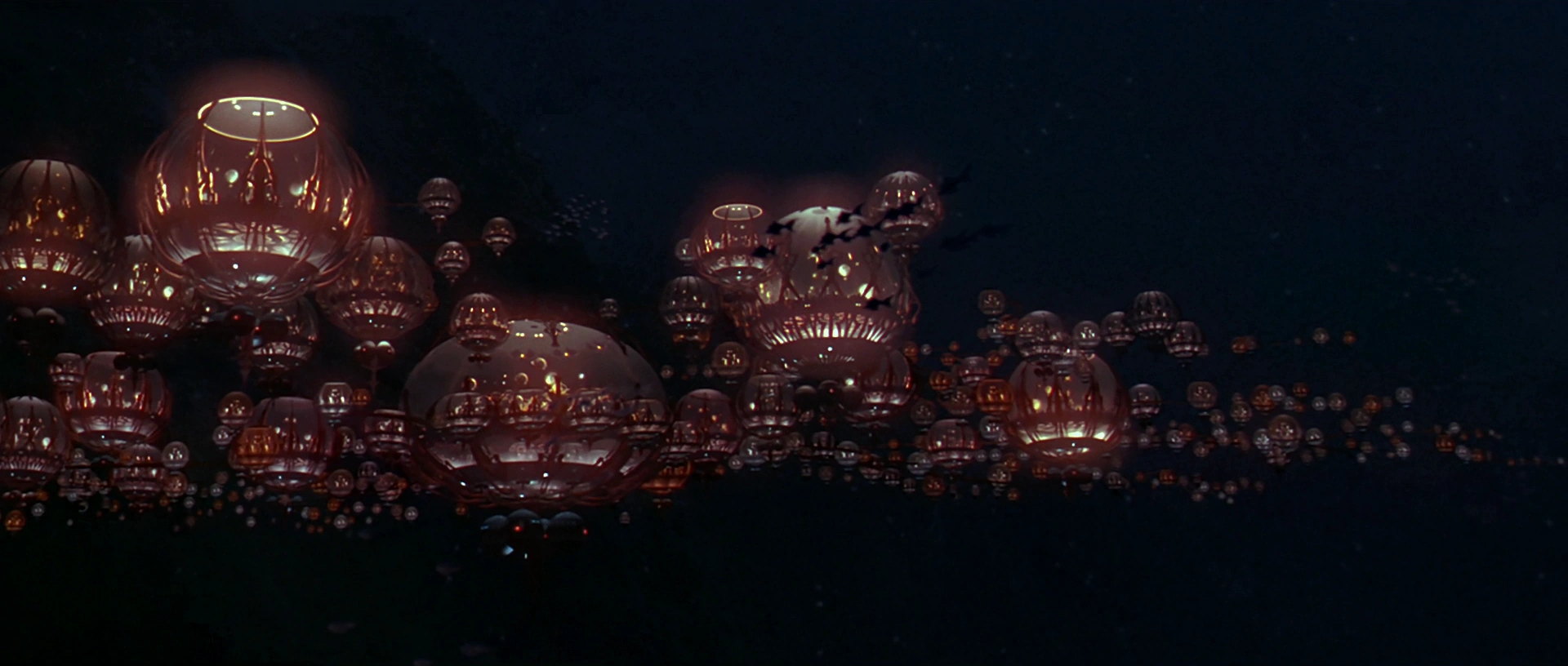
3. Gungan City
Gungan City. Image from Star Wars.
Return to Naboo for the secret underwater Gungan City. It’s beautiful, but like all things Gungan, it makes little sense.
With a fairly small number of orbs that appear to be mostly empty air, Gungan City is clearly more of a village than a metropolis. Maybe the Gungans prefer isolation, or maybe they’re too clumsy to live many side-by-side. Hopefully we’re never forced to sit through more Gungan scenes, and therefore never find out.
One would think that if Gungans are such great swimmers that they’re happy to build underwater cities, they’d spread their city vertically as much as sideways. Guess not.
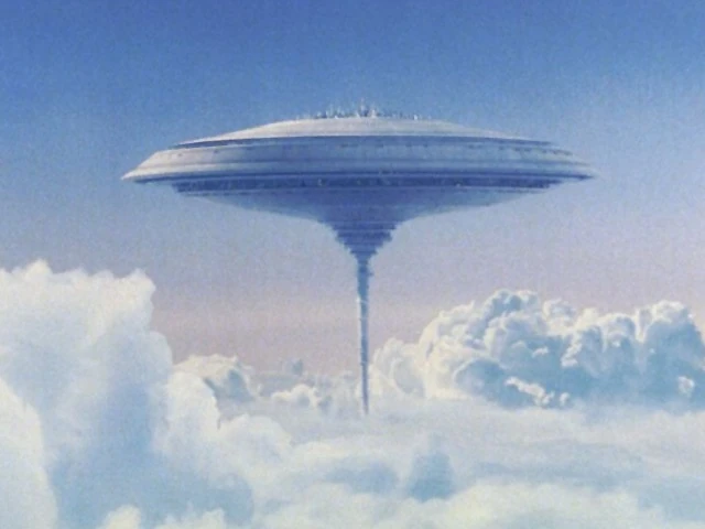
2. Cloud City
Cloud City. Image from Star Wars.
High-concept sci-fi at its best, Cloud City is an atmosphere-mining colony on a gas giant planet with no solid surface.
Its workers harvest gases for use in Star Wars’ futuristic technologies, and its government is more corporate CEO than democratic president.
Being an expensive floating factory, Cloud City’s layout and infrastructure are necessarily vastly different from a cobbled-together frontier town like Mos Eisley. As a single, purpose-designed mega-structure, Cloud City needs nothing so messy as parking lots, and piecemeal expansions are strictly not happening.
And if you approach it without an invitation, cloud cars shoot at you. It’s the ultimate gated community.
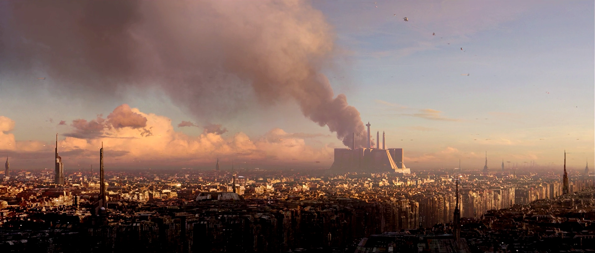
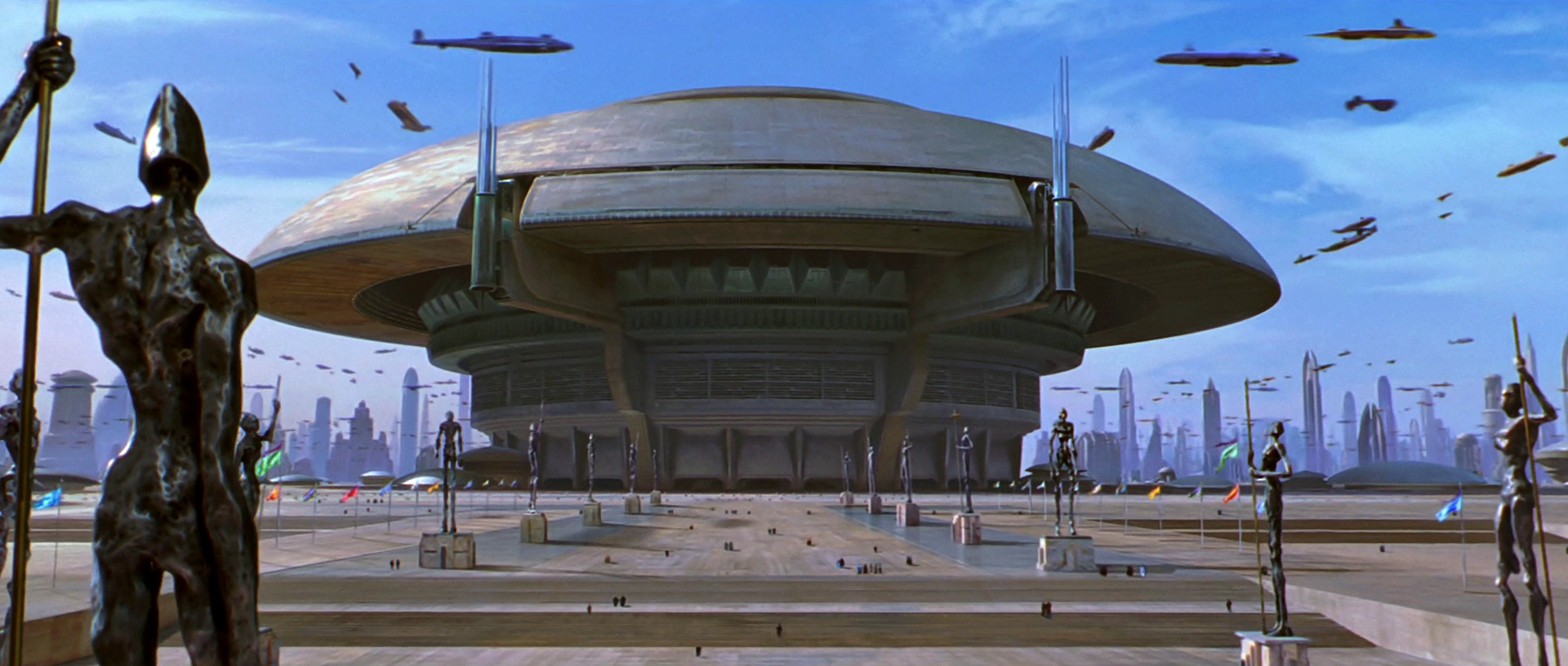
1. Coruscant
Coruscant. Image from Star Wars.
One city that covers a whole planet. Coruscant is either the ultimate in sprawl, or the ultimate in extreme urbanization. Given what we’ve seen on-screen, it seems to be the latter.
Like Washington, the capital of the Star Wars galaxy clearly has a height limit, with a canopy of blocky same-height buildings rolling over the landscape, and monuments like the Jedi Temple (above) dominating the skyline. But unlike DC, Coruscant’s city planners allow frequent skyscrapers to pierce the blocky canopy.
Unlike other Star Wars cities, Coruscant features busy air-highways, crowded with flying transports. But there don’t seem to be enough vehicles to move around a population as dense as Coruscant’s must be. Surely the planet is a public transit paradise.
Coruscant’s galactic capitol building, with air-highways. Image from Star Wars.
What will we see next?
If the past is any guide, The Force Awakens promises even more aliens and sci-fi landscapes. When I see it, I’ll be hoping to see some fun cityscapes too. And, I admit, a few light-saber duels.
In the mid 1970s, Metro’s first stations were under construction and on track for their 1976 opening day. This historic photo shows Metro Center station while it was under construction, circa 1975.
Metro Center circa 1975. Photo source unknown.
In the photo, the basic form of the station is in place. The vault is done, the track bed looks good, and the station’s lights are on. But there’s clearly a lot of work left to do, including most of the finishing touches.
It’s an interesting 40-year-old look at one of our region’s most important transit hubs.
It won’t appear immediately, but DC took a big step toward speeding up buses on 16th Street by recommending a rush-hour bus lane and a package of other ways to make bus service better.
Independence Day was the biggest summer blockbuster of 1996. In the movie, aliens invade Earth, destroy DC, New York, and most of the world’s major cities. Eventually Will Smith, Bill Pullman, and Jeff Goldblum beat the aliens and save humanity.
Now, 20 years later, the aliens are back and our heroes (minus Will Smith) are at it again.
In the still, you can clearly make out the National Mall on the far right, with the Capitol, Washington Monument, and Lincoln Memorial in order. Except apparently, post alien apocalypse, Arlington’s surviving community leaders rebuilt the Pentagon in place of Rosslyn.
On December 5, 1951, the world’s first “park-o-mat” driverless parking garage opened on K Street NW, between 14th and 15th Streets. The building doesn’t exist anymore, but this newsreel is a neat look into one of history’s previous attempts at driverless transportation.
The original park-o-mat buildling was just 25 feet by 40 feet, but at 16 floors and with two elevators, it had room for 72 cars.
As downtown DC developed and the city’s height limit began to limit land availability, property values eventually made it impractical to keep using this building as parking. Today, a a normal building full of people replaces it.
But automated parking does still exist. At least one apartment building in DC, the Camden Grand Parc, has an automated garage. And New York’s first “robotic” parking garage opened in 2007.
The redevelopment boom on H Street NE hasn’t yet transformed Hechinger Mall, the big suburban-style strip mall where H Street meets Bladensburg Road and Benning Road. But someday, when it inevitably does, there’s enough land for an entire neighborhood.
By superimposing a map of the Hechinger Mall area on top of other parts of DC, one can see just how great a change is on the horizon.
Hechninger Mall and surrounds by Dan Malouff using Mapfrappe and Google.
In the above image, the blue line outlines Hechinger Mall plus several surrounding properties with similar car-oriented retail. The mall and its surrounds beat as the commercial heart of multiple Northeast neighborhoods, including Trinidad, Carver-Langston, and Kingman Park.
It’s not unused land; there are plenty of stores, and they do robust business. But it’s definitely underused. Vast acres of parking sit mostly empty. Single suburban-style stores take up entireblocks. Internal streets look like highways, despite low traffic.
Someday it is going to redevelop. When that happens, it’s going to be as much a big deal as redevelopment in Columbia Heights or Union Market.
Compare the land
Let’s compare the amount of land we’re talking about.
Using a neat tool from Mapfrappe, it’s possible to superimpose that blue Hechinger Mall outline on top of other parts of DC, at the same scale.
Here’s Columbia Heights:
Columbia Heights comparison by Dan Malouff using Mapfrappe and Google.
As you can see, the blue Hechinger Mall outline is almost exactly the same size and shape of the center of Columbia Heights. You could almost pick up 14th Street and plop it down at Hechinger, and it would fit.
Now Union Market:
Union Market comparison by Dan Malouff using Mapfrappe and Google.
Again, it’s almost exactly the same size as the entire Union Market neighborhood.
Let’s keep going. NoMa next:
NoMa comparison by Dan Malouff using Mapfrappe and Google.
City Center comparison by Dan Malouff using Mapfrappe and Google.
NoMa is bigger. But Hechinger Mall is about the same size as the others. That’s the scale of redevelopment that could—that probably will—come to H Street.
And that’s great. There’s nothing wrong with the stores at Hechinger; DC needs shops like Safeway, Ross, and Dollar Tree. But DC also needs places to put more housing, and football field-sized parking lots a mile-and-a-half from the Capitol are exactly the right place.


 Comment on this at the version cross-posted to Greater Greater Washington.


