|
Special Features


Image Libraries


|
|
Blog
|
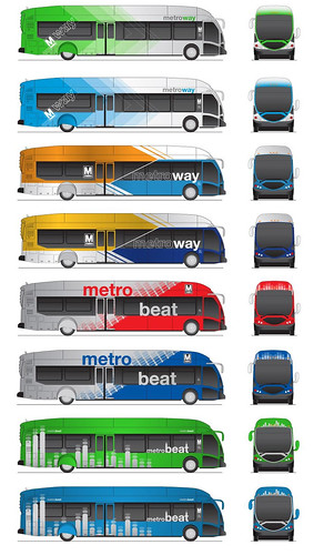
Potential WMATA BRT brands. |
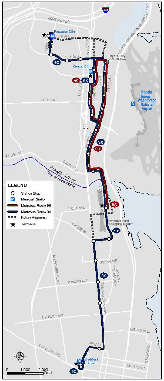
The Washington region’s first BRT line will open in 2014, running from Crystal City to Alexandria. It will have a dedicated transitway, stations rather than stops, and other amenities above and beyond any other bus line in the region. It will need a fresh brand; WMATA’s MetroExtra look won’t do, since MetroExtra is a much more limited service than BRT.
Thus, WMATA has proposed 2 potential names, and 8 possible paint schemes.
All the paint schemes are vivid and colorful, which is a good thing. High quality services should stand out, so a bright bus livery is appropriate.
My favorite is the blue arrowhead option. The forward-facing arrowheads impart speed, and the blue ties back to MetroExtra, relating WMATA’s 2 premium bus brands under a similar banner.
I’m not a huge fan of either proposed name. Both MetroWay and MetroBeat seem forced, and arbitrary. MetroBeat especially runs the risk of being read as Beat Metro, an unfortunate pun sure to be used mockingly any time something goes wrong.
I’d prefer MetroRapid, a brand Los Angeles uses for a premium (but non-BRT) service that’s similar to WMATA’s MetroExtra.
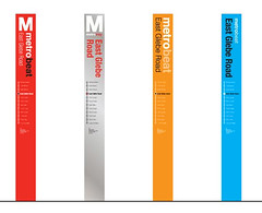
WMATA also proposes 4 potential pylon options for use at stations. I prefer the options without the large capital M, which I think look a little too similar to Metrorail pylons. But all 4 are good.
If you want to share your opinion about these proposals, WMATA has a survey.
Average Rating: 4.6 out of 5 based on 198 user reviews.
March 11th, 2013 | Permalink
Tags: BRT, bus, transportation

Denver is in the midst of a huge regional rail expansion. That’s great, but like in many cities (including DC, historically), the urban bus system has been largely ignored amidst all the hubbub over rail.
I got my planning degree at the University of Colorado, and after discussing Denver’s bus system with some friends recently, decided to produce this map. It shows the city’s high-frequency bus routes along with its existing and future rail lines.
Although the geography is obviously different, in many ways this map is a sequel to my DC 15-minute bus map from last August. I applied a lot of the lessons learned during that exercise to this Denver map. Compared to the DC version this map shows more information, presented more cleanly.
Read more at DenverUrbanism.com.
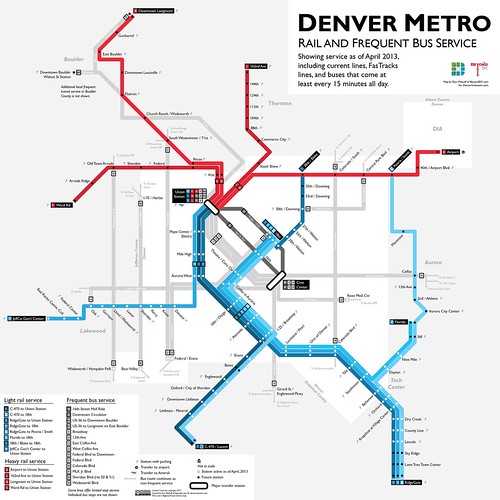
Denver rail and frequent bus map, including future lines. Click map for full size version.
Other sizes via flickr.
Average Rating: 4.5 out of 5 based on 210 user reviews.
February 27th, 2013 | Permalink
Tags: BRT, bus, commuterrail, lightrail, maps, streetcar, transportation
WMATA is considering 2 options to add more rush hour service to the 16th Street bus line near downtown. One option would start at either U Street or V Street, and the other would extend up Meridian Hill to Euclid Street.
WMATA’s two options for a new “short turn” 16th Street bus. Image by WMATA.
The 16th Street buses are overcrowded along the southern part of the S-series Metrobus line in the morning rush. Riders hoping to catch a bus south of Columbia Heights frequently watch one bus after another pass by without stopping, too full to take on any new passengers.
WMATA head bus planner Jim Hamre and his team presented the new route options at a meeting last night organized by Dupont ANC commissioner Kishan Putta.
Both options begin around Meridian Hill, serve all bus stops along 16th Street from there to Lafayette Park, and then run back north without stopping, in order to start over as quickly as possible.
Frequency versus coverage
WMATA only has 2 buses available to run this service, so the options present a choice of high frequency versus greater coverage.
The first option, on the left, is the easiest to operate and provides the greatest frequency. Buses in the morning rush hour would come every 15 minutes, in addition to the existing bus service. But the line would end at either U or V Street, and the crowding problems start farther north.
The second option, on the right, extends up Meridian Hill to Euclid Street. This would reach more passengers, but adds time and complication. Buses would only be able to run every 20 minutes at best. They would also get delayed more often because the streets around Meridian Hill are only a single lane and are often blocked by other vehicles.
Another potential complication for the second option is how buses would get back north. While northbound buses for the U/V Street option could use 14th Street, the only way to keep even 20 minute headways for the Euclid Street option would be to run northbound using 15th Street. 15th Street doesn’t currently have any buses, so residents there may have concerns.
Interestingly, Hamre said the worst crowding problems only appear during the morning rush, so this new supplement may only run in the morning. Evening rush hour buses are crowded too, but less excessively so. Riders aren’t usually being left behind in the evening.
There was widespread consensus at the meeting to support a rush hour supplement, but residents disagreed over which option is better. Eventually WMATA may be able to add service farther north and still provide good frequencies, but they’ll need more buses and more money to do it. In the meantime, they have to make do with only 2 buses, which means trade-offs.
Either way, riders on 16th Street should benefit. Even those from farther north should see improved service, since the buses they’re already on will move faster near downtown.
Theoretically the new route will be called the S3, although Hamre didn’t commit to that last night.
If everything goes smoothly, the new buses could roll down 16th Street as early as March 24. If there are delays then it could take longer.
Ultimately, Hamre said, WMATA also hopes to start “headway scheduling” on 16th Street. That means they would try to keep buses a certain distance apart rather than meet a predefined schedule. That works for Circulator buses, and for the 70s and 90s series Metrobuses, but it will take longer to implement, and is being considered a separate issue.
 Cross-posted at Greater Greater Washington. Cross-posted at Greater Greater Washington.
Average Rating: 4.6 out of 5 based on 169 user reviews.
February 21st, 2013 | Permalink
Tags: bus, transportation
|
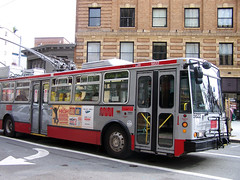
SF Muni bus. |
How do you stop car drivers from blocking bus lanes? Put cameras on buses, of course.
Unfortunately, transit lanes are often clogged by car drivers who either don’t know or don’t care that cars are not allowed in them. Enforcement is difficult, because violation is often so rampant that it’s not practical for the police to pull over every violating car.
DC’s 7th Street bus lane through Chinatown is a prime example.
But there is a solution. San Francisco is installing cameras on all its city buses, specifically to enforce the prohibition on cars in transit lanes. Human officers will review footage from the cameras and mail tickets to the owners of any cars illegally blocking the lane.
Bus cameras in San Francisco will not be used to ticket other types of moving violations such as speeding or running red lights. For now they won’t even be used to ticket car drivers that block bus stops. Current law prohibits any use other than ticketing transit lane violations.
Even that limited application will make a big difference, though. San Francisco has 17 miles of transit lanes, but without enforcement they’re no better at actually moving buses through traffic than 7th Street in DC.
If this idea works it could have a huge effect on bus planning nationwide. Bus lanes could become much more effective, and therefore likely to become more widespread.
Cross-posted at Greater Greater Washington.
Average Rating: 5 out of 5 based on 237 user reviews.
February 15th, 2013 | Permalink
Tags: bus, roads/cars, transportation
Both streetcars and buses come in many shapes and sizes, but if you need the capacity, streetcars can be much bigger. So far neither DC nor Arlington has proposed a streetcar this long, but they’re possible.
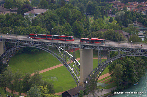
Tram and bus in Bern, Switzerland. Photo by Keith McGilivray on flickr.
Average Rating: 4.9 out of 5 based on 157 user reviews.
February 13th, 2013 | Permalink
Tags: bus, streetcar, transportation
This was spotted on a bus in Manchester, UK, where apparently the phrase “war on cars” takes on new meaning.

Photo from reddit user Onoj.
Average Rating: 4.9 out of 5 based on 259 user reviews.
February 7th, 2013 | Permalink
Tags: bus, fun, transportation
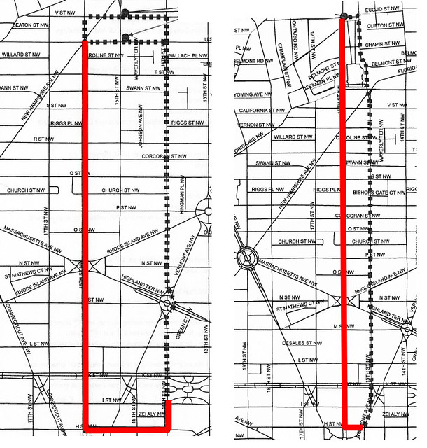
|
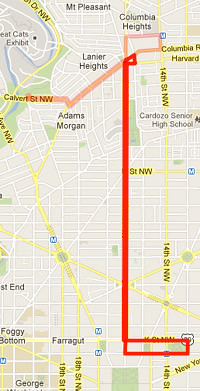
What the new S3 bus route *could* look like. Pink lines are alternate routes. |
WMATA is considering tweaking the busy 16th Street bus line with a new route that would run only between Columbia Heights and downtown. The change is proposed to relieve extreme crowding on the S-series Metrobuses.
Why it’s necessary and fair
Imagine if most rush hour Orange Line trains blew through all the Arlington stations without stopping. Would that be fair to riders in the Rosslyn-Ballston corridor?
That’s essentially what is happening today on WMATA’s 16th Street bus line. It’s so crowded during peak hours that buses often have to stop picking up passengers, forcing riders south of Columbia Heights to watch while one bus after another passes by without stopping.
WMATA added more articulated buses in June. That made a noticeable difference, but the problem didn’t go away completely. Adding still more articulated buses isn’t an option, because there’s not enough parking space at bus storage yards.
Last Monday community members met with WMATA bus planners, and devised a potential solution: add a new route to the S-series that only goes as far north as Columbia Heights.
That makes a ton of sense. It would be a natural counterbalance to the S9, which provides a great service for riders making long trips, but is essentially useless for close-in riders. This new route would provide a correspondingly great service for close-in trips.
What it will look like
Presumably if the new route moves forward it will be called the S3.
WMATA’s naming convention for buses starting with letters is that even numbered routes run all day, odd numbered routes run only at peak times, and high numbers go to express lines. So the S1 is a local route that runs only at rush hour, the S9 is a rush hour express, and the S2 and S4 are all day locals. S3 is the next available slot for another rush hour local. S5 is another possibility, but S3 seems more likely.
Obviously the new S3 will use 16th Street, but where it terminates on its north and south ends is an open question. The attached map shows one possibility.
One of the reasons 16th Street buses are so successful is that they’re simple. Riders can reasonably expect any bus they board on 16th Street to stay on 16th Street. That simplicity needs to be protected as much as possible, so the S3 should avoid deviating too far from the S2 and S4.
Another reason to avoid going very far east or west is simply to save time. The main purpose of the S3 will be north-south travel, so time spent going east or west is wasted. Wasted time means more buses will be necessary.
On the north end Columbia Heights is the obvious target for a terminus, since that’s about where the capacity problems start to become serious. On the map, I’ve shown a simple turnaround that keeps the bus close to 16th Street, but the route could go east to 14th Street to provide a Metrorail transfer, or west to the Calvert Street trolley turnaround to provide a bus layover parking spot.
Another option would be to stop somewhere along U Street, and not go as far north as Columbia Heights at all.
On the south end, the existing S-series gets complicated. The S1 turns west and goes to Foggy Bottom, the S2 and some S4s turn east and go to Federal Triangle, while the S9 and the rest of the S4s make a quick turnaround at Franklin Square.
At rush hour all the S buses empty out considerably at K Street, so S3 will get the biggest bang for its buck if it turns around as soon after K Street as possible.
That’s probably why the S9 ends at Franklin Square, and is probably why it will make sense for the S3 to do the same.
No matter how this idea evolves, it’s a great conversation to have. This is exactly the kind of creative planning that marks a great transit agency, and productive community leaders. Kudos to Dupont ANC commissioner Kishan Putta and WMATA bus planner Jim Hamre for making this proposal.
Average Rating: 4.8 out of 5 based on 271 user reviews.
February 5th, 2013 | Permalink
Tags: bus, transportation
Tysons Corner has more office space than downtown Baltimore, Richmond, and Norfolk put together. It should be the center its own large transit network. The Silver Line and express buses on the Beltway HOT lanes are good first steps, but in the long run Tysons is going to need more routes, connecting it to more places.
In the long run, Tysons needs something more like this:
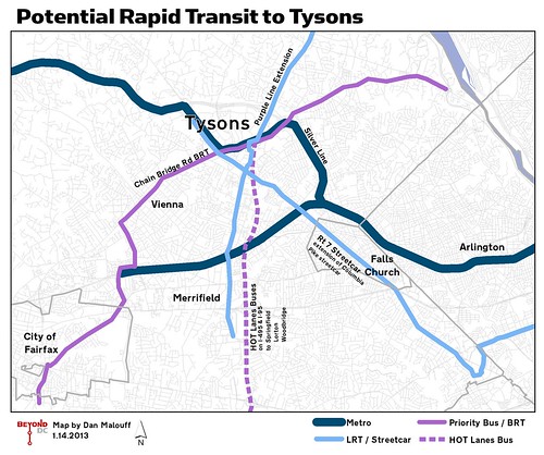
In recent years, planners in Virginia have begun to seriously consider a Tysons-centric rapid transit network. It doesn’t have a name, and isn’t officially separate from any of the other transportation planning going on in the region, but it shows up on long range regional plans like SuperNoVa and TransAction.
In addition to the Silver Line, HOT Lanes Buses, and Tysons’ internal circulation network, officials are beginning to study light rail connections to Maryland, Falls Church, and Merrifield, and BRT on the Chain Bridge Road corridor.
It will be years before any of these additional routes are implemented, and they could look very different from this map once they finally are. Details don’t exist yet, because at this point these are little more than ideas.
But to work as the urban place Fairfax County officials hope Tysons will become, this is the sort of regional infrastructure it’s going to need.
Cross-posted at Greater Greater Washington.
Average Rating: 4.4 out of 5 based on 272 user reviews.
January 14th, 2013 | Permalink
Tags: BRT, bus, lightrail, metrorail, streetcar, transportation
Flickr user davidwilson1949 has a collection of over 100 historic transit pictures from the DC area, dating from the 1970s forward. Fun and fascinating stuff. Here are two of his images:

Articulated Metrobus, 1979. |

Ride-On bus, 1979. |
Average Rating: 4.4 out of 5 based on 219 user reviews.
December 17th, 2012 | Permalink
Tags: bus, fun, history, transportation
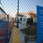
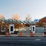
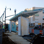
|
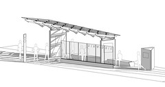
Rendering of a completed Super Stop. |
Arlington County has been planning a series of 24 “Super Stops” along Columbia Pike. The new bus stops will have expanded shelter and seating, electronic real-time arrival displays, maps, and a raised curb platform. They’re intended to be more like light rail stations than bus stops.
Eventually the Super Stops will actually be light rail stations for the Columbia Pike streetcar, but until that opens they’ll only serve buses.
The first Super Stop is under construction now, and beginning to take shape. It’s at the corner of Walter Reed Drive, and is scheduled to open in the coming weeks. Here are three pictures of the progress, taken last Wednesday.
Average Rating: 4.8 out of 5 based on 157 user reviews.
November 26th, 2012 | Permalink
Tags: bus, development, streetcar, transportation
|
Media


Site
About BeyondDC
Archive 2003-06
Contact
Category Tags:
Partners
|


