|
Special Features


Image Libraries


|
|
Blog
The latest draft of DDOT’s citywide transportation plan, moveDC, calls for a massive expansion of transit and cycling facilities throughout the District, plus new tolls on car commuters. If the District adopts it, the plan will become one of America’s most progressive.

The moveDC plan summary map. All images from DDOT.
DDOT released the latest version of moveDC last Friday, launching a month long public comment period in anticipation of a DC Council hearing on June 27. Following that, the mayor will determine any changes based on the comment period, with final adoption anticipated this summer.
What’s in the plan
Amid the hundreds of specific recommendations in the plan, three major proposed initiatives stand out:
- A vastly improved transit network, with 69 miles of streetcars, transit lanes, and improved buses, plus a new Metrorail subway downtown.
- A massive increase in new cycling infrastructure, including the densest network of cycletracks this side of Europe.
- Congestion pricing for cars entering downtown, and traveling on some of DC’s biggest highways.
Transit

Proposed high-capacity transit network (both streetcars and bus). Blue is mixed-traffic, red is dedicated transit lanes.
The plan proposes to finish DC’s 22-mile streetcar system, then implement a further 47-mile high-capacity transit network that could use a combination of streetcars or buses. That includes 25 miles of dedicated transit lanes, including the much requested 16th Street bus lane.
Although the proposed high capacity transit corridors closely mirror the 37-mile streetcar network originally charted in 2010, there are several new corridors. In addition to 16th Street, moveDC shows routes on Wisconsin Avenue, both North and South Capitol Streets, H and I Streets downtown, and several tweaks and extensions to other corridors.
The plan endorses WMATA’s idea for a new loop subway through downtown DC, but explicitly denies that DC can fund that project alone.
MoveDC also shows a network of new high-frequency local bus routes, including Connecticut Avenue, Military Road, Alabama Avenue, and MacArthur Boulevard.
Bicycles
MoveDC also includes a huge expansion of trails and bike lanes, especially cycletracks.

Proposed bike network. The pink lines are cycletracks.
Under the plan, DC would have a whopping 72 miles of cycletracks crisscrossing all over the city. From South Dakota Avenue to Arizona Avenue to Mississippi Avenue, everybody gets a cycletrack.
Meanwhile, moveDC shows major new off-street trails along Massachusetts Avenue, New York Avenue, and the Anacostia Freeway, among others.
Tolls for cars
Congestion pricing is clearly on DDOT’s mind, with multiple proposals for new variable tolls in the plan.

Proposed downtown cordon charge zone.
The most aggressive proposal is to a declare a cordon charge to enter downtown in a car. This idea has worked in London and has been discussed in New York and San Francisco, but so far no American city has tried it.
Meanwhile, some of the major car routes into DC would also be converted to managed lanes. Like Maryland’s ICC or Virginia’s Beltway HOT lanes, managed lanes have variable tolls that rise or fall based on how busy a road is.
MoveDC proposes managed lanes on I-395, I-295, New York Avenue, and Canal Road.
What will the council think?
DDOT has produced a very strong plan, but is it going anywhere? The DC Council will discuss moveDC on June 27, at which time we’ll find out if the same people who pulled the rug out from under streetcar funding are interested in progressive policy-making, at least.
Even if DC does adopt this plan, whether the council will actually provide the funds necessary to build it is anybody’s guess.
Correction: An earlier version of this story reported the DC Council will approve or deny this plan. Authority to approve it actually rests solely with the mayor.
 Cross-posted at Greater Greater Washington. Cross-posted at Greater Greater Washington.
Average Rating: 4.4 out of 5 based on 163 user reviews.
June 2nd, 2014 | Permalink
Tags: bike, BRT, bus, government, lightrail, master planning, metrorail, roads/cars, streetcar, transportation

|
Image from WMATA. |
Yesterday morning WMATA took control of the Silver Line from construction teams, declaring the line has reached “operational readiness.” Metro now begins a 90-day testing and training period, prior to opening service this summer.
The Metropolitan Washington Airports Authority (MWAA) owns the Silver Line and has been in charge of construction. Yesterday’s action officially transferred day-to-day control, management, and operations of the line to WMATA.
Following testing, opening day for passengers should come a little before or after the 90-day period runs out. The WMATA Board will set the exact date. If testing goes well, August seems the most likely bet.
The Silver Line was originally intended to open in December 2013, but construction delays and technical adjustments have pushed it out to this summer.
But now Metro officials think the delays are over. According to Metro Deputy General Manger Rob Troup, “We would not have reached this [point] if we were not confident of being able to do the testing within the time frame.’’
Average Rating: 4.4 out of 5 based on 173 user reviews.
May 28th, 2014 | Permalink
Tags: metrorail, transportation
Not to be outdone by its neighbors’ aggressive plans for rail and BRT networks, Fairfax County has an impressive transit plan of its own.
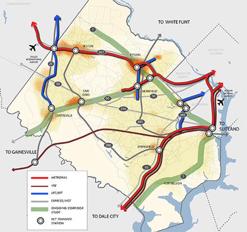
Fairfax County’s proposed high quality transit network. Image from Fairfax.
DC has its streetcar and moveDC plans, Arlington and Alexandria have streetcars and BRT, and Montgomery has its expansive BRT network, plus of course the Purple Line.
Now Fairfax has a major countrywide transit plan too, called the High Quality Transit Network.
Fairfax’s top priorities are to finish the Silver Line and the Bailey’s Crossroads portion of the Columbia Pike streetcar, but that’s not the end of their plans.
County planners are also looking at several other corridors, including Route 1, Route 7 (both east and west of Tysons), I-66, Route 28, and Gallows Road/Dolly Madison Boulevard.
Both rail and BRT are possibilities for all those corridors. Some may end up light rail or streetcar, others bus. Route 1 and I-66 could even include Metrorail extensions.
In addition to all that, Fairfax County Parkway is slated for HOT lanes, which could make express buses a more practical option there.
As the DC region continues to grow, and demand for walkable, transit-accessible communities continues to increase, these types of plans are crucial. If our major arterial highways are going to become the mixed-use main streets of tomorrow, transit on them must significantly improve.
Fairfax is undeniably still spending a lot on bigger highways. Planners’ inability to calm traffic on Routes 7 and 123 through Tysons, for example, indicates roads are still priority number one. But it takes a plan to change, and this is a strong step forward. So good on Fairfax for joining the club.
Cross-posted at Greater Greater Washington.
Average Rating: 4.8 out of 5 based on 289 user reviews.
April 22nd, 2014 | Permalink
Tags: BRT, land use, lightrail, master planning, metrorail, roads/cars, streetcar, transportation
Fairfax County is considering dressing up the Silver Line’s mammoth concrete pylons with murals. The idea could help animate the otherwise bleak, gray structures.
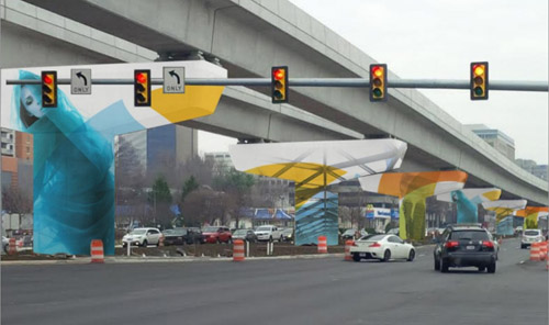
Mock up of a possible Silver Line mural. Image from the Tysons Partnership.
Ideally the Silver Line would’ve been underground through Tysons Corner. But federal rules that have since changed prevented that, forcing the Metro line above ground, onto a huge elevated structure.
That wasn’t the end of the world, but it did condemn Tysons to some unnecessary ugly.
So why not dress it up? Murals can unquestionably make big gray structures more colorful and interesting. They’re easy to implement, don’t cost very much, and help a little. There’s not much down side.
Murals are, however, still just lipstick on a pig. They don’t solve the underlying deadening effect of bare walls. For example the Discovery building mural on Colesville Road in Silver Spring is surely better than bare concrete, but shops & cafes would’ve been better still.
And Tysons’ murals won’t be as effective as the one in Silver Spring. Colesville Road is basically urban, basically walkable. The block with the mural is the weakest link on an otherwise lively urban street.
But in Tysons, the Silver Line runs down the middle of Leesburg Pike, one of the most pedestrian-hostile highways in the region. If murals are added to the Silver Line, they may become the best and most interesting part of the streetscape, as opposed to the worst.
So by all means, Fairfax County should absolutely do this. Murals are a great tool to cover any large blank structure. But what Tysons really needs is walkable streets with lively sidewalks.
Cross-posted at Greater Greater Washington.
Average Rating: 5 out of 5 based on 265 user reviews.
April 11th, 2014 | Permalink
Tags: architecture, metrorail, transportation, urbandesign
I’m on vacation in Europe until the 24th. Each weekday until my return there will be a brief post about some feature of the city I’m visiting that day.
You can get anywhere on the Paris Métro. This map shows central Paris, with a 500 meter radius (roughly 1/3 mile) circle around every Métro and RER station. The entire city has subway station density comparable to downtown DC. Everywhere is within a short walk of at least one station.
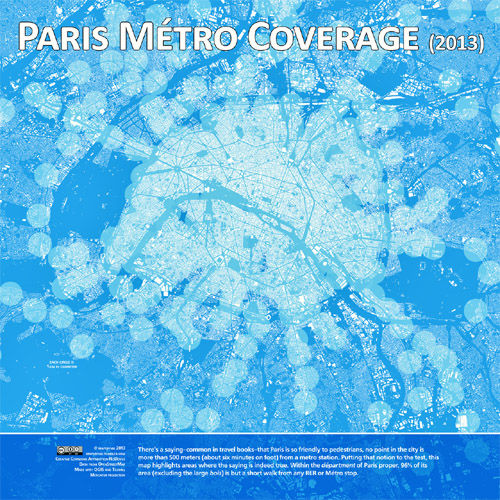
Map by mapsbynik on tumblr.
Average Rating: 4.7 out of 5 based on 180 user reviews.
March 14th, 2014 | Permalink
Tags: metrorail, transportation
There’s good news and bad news at the Reagan Airport Metro station. The bad news is an elevator is out of service, leaving one of the train platforms without elevator access. The good news is WMATA came up with a delightfully clever solution: Park a Metro railcar on the extra track between the two platforms, and use it as a pedestrian bridge to access the platform with the working elevator.
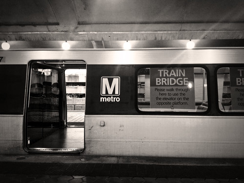
Metrorail “train bridge” at National Airport. Photo by Lily Monster on flickr.
The Metro station at Reagan National Airport has an unusual layout, with three rail tracks instead of the more normal two. There are two outside tracks, plus a third middle track. Two island platforms flank the middle track, each of them providing access to both the middle track and one of the outside tracks. West Falls Church has a similar layout.
The middle track is not actually necessary for day-to-day operations. So Metro parked a railcar on it and opened its doors, allowing passengers waiting on one of the platforms to use the railcar as a bridge to reach the other.
Thus passengers who need an elevator can access one. There’s no need to detour them to another station and make them wait for a shuttle.
WMATA is sometimes criticized for being overly bureaucratic, rigid, and slow to solve problems. But they deserve credit for this, a nimble and inexpensive solution that genuinely makes riding the system a little easier.
Cross-posted at Greater Greater Washington.
Average Rating: 5 out of 5 based on 150 user reviews.
March 12th, 2014 | Permalink
Tags: metrorail, transportation
Last week, the first three of Metro’s new 7000-series railcars arrived at the Greenbelt railyard.
A 4th car is scheduled to arrive next week, after which Metro will begin testing them. The bulk of the new railcars won’t begin to arrive until several months later. Riders will begin to see them in service late in 2014.
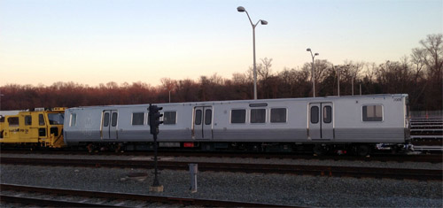
7000-series Metro car at Greenbelt yard.
Cross-posted at Greater Greater Washington.
Average Rating: 4.6 out of 5 based on 161 user reviews.
December 24th, 2013 | Permalink
Tags: metrorail, transportation
Despite years of planning to transform Tysons Corner from a car-oriented edge city into a walkable downtown, some Virginia residents are surprised to learn that Tysons’ 4 Metro stations will not be surrounded by parking lots.
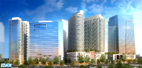
Development planned at the Spring Hill Metro station. Image from Fairfax County.
The confusion seems to stem from a mix-up about what Metro stations in Tysons Corner are supposed to accomplish. Are they places for DC-bound commuters to board, or are they the destination stations for people working in Tysons? There will surely be some of both, but most users will be the latter, and they’re who the line must be designed to best serve.
If stations are surrounded by parking that will reduce the number of buildings within walking distance of Metro. Not only that, it would also make the walk less interesting and more dangerous, since walking through a busy parking lot is hardly a pleasant experience. That in turn would reduce the number of people who could use Metro to commute to Tysons. That would undermine the entire project.
The main purpose of the Silver Line project is to transform Tysons Corner. Tysons is a behemoth, with about the same amount of office space as downtown Baltimore. It can’t grow or continue to prosper as a car-oriented place. Nor would it make sense to invest almost $7 billion in a new Metrorail line if it were not going to support a more urban Tysons, or serve easy commuting into Tysons.
Consider other walkable downtown areas, like downtown DC or Rosslyn. Would it make sense if Gallery Place Metro station were surrounded by parking instead of buildings? Of course it would not. Tysons will one day be the same. It may not look like that yet, but it never will if its best land is used for parking lots.
Yes, it’s true there should be enough parking along the Dulles Corridor for commuters into DC to use the system. That’s why there are large parking lots at the Wiehle Avenue and West Falls Church stations. There’s no need for drivers to enter congested Tysons Corner to find parking, when more highway-oriented stations exist specifically for that purpose.
Alternatively, those few drivers who do want to park in Tysons will surely be able to do the same thing they do in Ballston, DC, Bethesda, or anywhere else: Pay to park in a nearby garage, and walk a couple of blocks. As more new buildings are built near Metro stations, there will be more available private garages to pick from.
There may be some small number of people currently living in Tysons who refuse to walk to stations, and will have to drive out of Tysons to find parking. That’s unfortunate, but accommodating them with parking lots at urban stations would make those stations less convenient for the larger number of walkers, and future walkers.
Temporary parking isn’t a panacea
Some suggest that since it may be a few years before all the land near Metro stations is developed, it could be used as interim parking on a temporary basis. In fact, that’s exactly the plan at the McLean station, where 700 parking spaces will be available at first.
That could be a workable idea in a few places, especially at McLean, which is the easternmost of Tysons’ 4 stations. But it’s less practical than some may assume, because most of the land surrounding these stations isn’t currently empty.
For example, Greensboro station is surrounded by strip malls. They will eventually be redeveloped into high-rises, but in the meantime the property owners make more money with retail there than they would with just parking.
In places where Fairfax County or WMATA can strike deals with landowners to let Metro riders use existing parking lots, that’s fine. But it does not make sense to tear down functional money-making buildings and replace them with temporary parking lots. Especially when there are better parking options elsewhere for drivers hoping to park and ride.
The bottom line is that Tysons Metro stations were planned correctly. Some interim measures are OK if they’re practical, but surrounding Tysons Metro stations with parking would undermine the entire reason for running the Silver Line through Tysons in the first place.
Cross-posted at Greater Greater Washington.
Average Rating: 4.6 out of 5 based on 203 user reviews.
December 3rd, 2013 | Permalink
Tags: metrorail, roads/cars, transportation, urbandesign
|
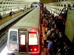
Packed Metro platform. |
Following a week of terrible Red Line Metro service, WMATA is offering refunds to riders who were inconvenienced. That’s a nice gesture, and perhaps it’s appropriate as a special measure when the same customers are hit with so many unexpected delays in such a short time. But in general, refunds are not the answer to Metro’s woes.
Yes, customers deserve to receive the service they’ve paid for, and yes, it’s satisfying to hold WMATA financially accountable when it doesn’t meet expectations. Those are the arguments in favor of refunds, and admittedly they’re compelling.
But if WMATA actually gave refunds every time there was a breakdown (which as we all know is unfortunately frequently), what would the side effects be? As always, follow the money.
For one, it would slow Metro’s reconstruction efforts, by diverting funding away from maintenance work. This painful period of single tracking and service interruptions would likely last years longer.
That’s bad enough, but consider WMATA’s likely response the next time there’s an unexpected rush hour breakdown. Instead of allowing thousands of passengers to continue entering the system and paying fares after the breakdown starts, only to be due refunds later, Metro would probably start to simply shut down entire lines. After all, you can’t demand a refund if you were never allowed to enter in the first place.
So on days like Wednesday, instead of bad service Metro riders might be left with no service at all. I don’t think that’s better.
At some point WMATA does need to be held accountable, so perhaps it was appropriate to offer refunds this week. But Washingtonians should neither demand nor expect a refund every time we have to wait for single tracking. Ultimately, improving Metro service back to the point where these delays don’t happen so often is what we really want. Frequent refunds wouldn’t help that goal.
Cross-posted at Greater Greater Washington.
Average Rating: 4.7 out of 5 based on 245 user reviews.
November 15th, 2013 | Permalink
Tags: funding, metrorail, transportation
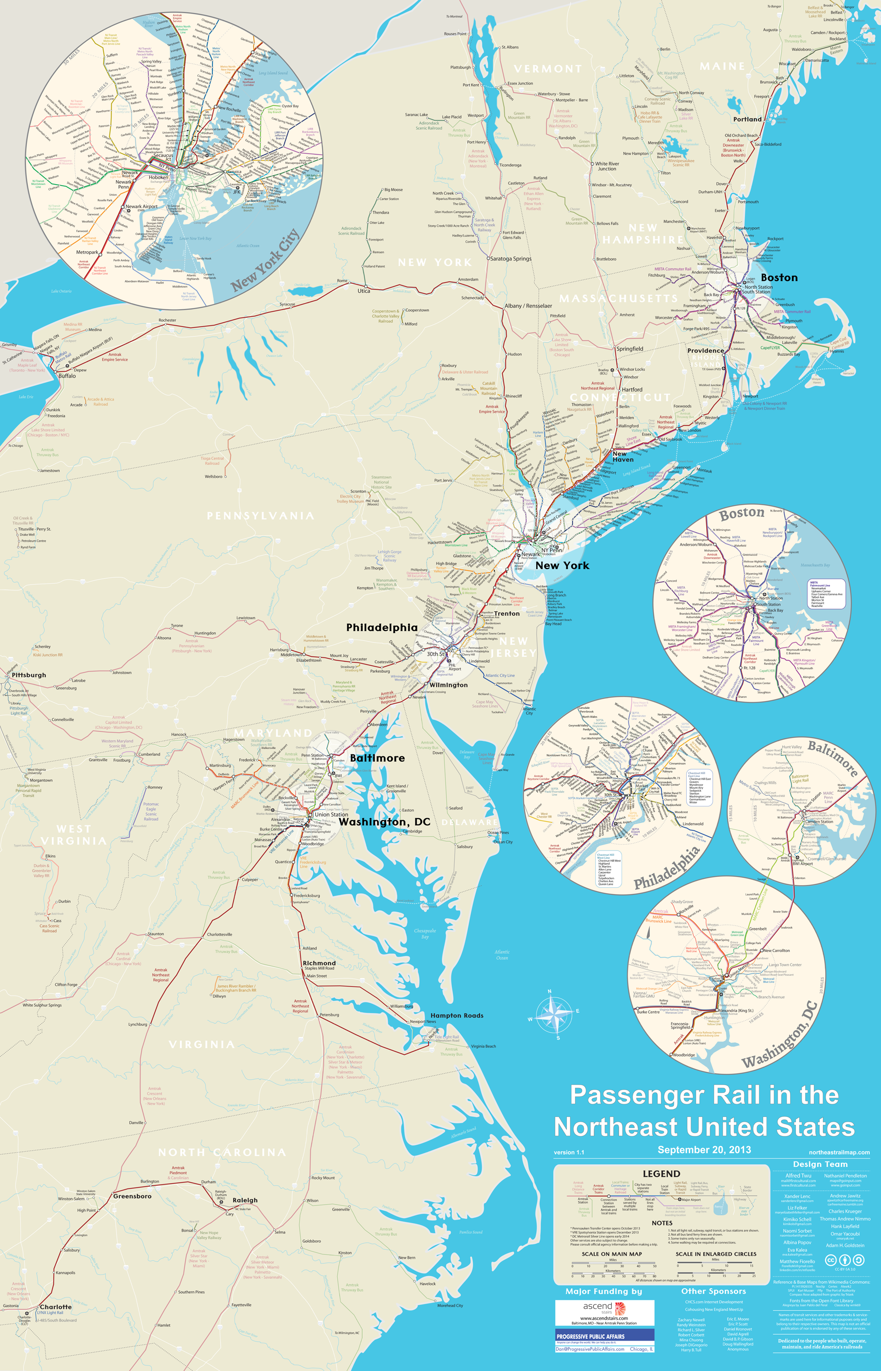
This map shows every Amtrak, commuter rail, metro, light rail, and tourist rail line from Maine to North Carolina, to scale.
It comes from NortheastRailMap.com, and you can even download it in a fully-editable Adobe Illustrator format.
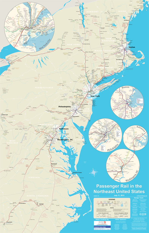
Image from NortheastRailMap.com.
Update: The map’s author has requested that you “like” their page on Facebook. Please help them out and do that!
Cross-posted at Greater Greater Washington.
Average Rating: 4.6 out of 5 based on 286 user reviews.
November 5th, 2013 | Permalink
Tags: commuterrail, intercity, lightrail, maps, metrorail, streetcar, transportation
|
Media


Site
About BeyondDC
Archive 2003-06
Contact
Category Tags:
Partners
|