|
Special Features


Image Libraries


|
|
Blog
The northern lights, aurora borealis, are usually only visible near the Arctic Circle. But every once in a while, when conditions are perfect, they make an appearance as far south as DC. I caught a glimpse early Wednesday morning.
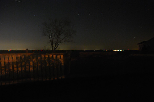
Aurora over Chesapeake Bay on Wednesday morning.
On Tuesday news spread that a heavy solar storm was hitting Earth, and producing some of the strongest aurora in years. Maybe strong enough to see from DC.
Since the sky was clear, the moon below the horizon, and conditions perfect, my wife and I booked a Zipcar to the clearest northerly view I could think of: The northern tip of Kent Island, across the Bay Bridge, in the middle of the Chesapeake.
And there was the aurora. Barely visible, but there. Dim green flashes floated low against the horizon, flowing in great fast waves from east to west. It was nothing like the huge curtains of light you see in the famous pictures (we’re too far south for that), but it was unmistakable nonetheless.
How you can see them next time
Aurora are sometimes visible from DC’s latitude. But they may never be visible from inside the District of Columbia, because this far south they appear very dim, and only close to the northern horizon. To see them, find an extremely dark north-facing vantage point, with a clear sight of the horizon.
If there are street lights turned on or trees blocking the horizon, you probably won’t see them even if conditions are otherwise right.
Since we live in Northeast, we decided Kent Island would be ideal. It’s about an hour drive east of DC, assuming no traffic—usually a safe assumption after midnight.
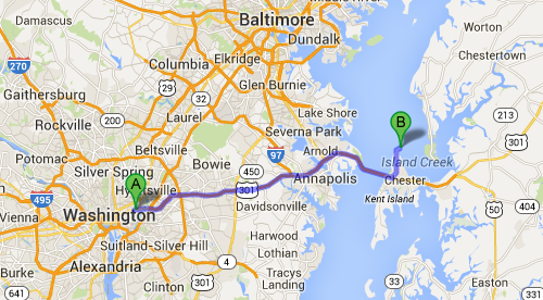
Route to Kent Island. Map from Google.
You will need a car to get there. And since news of likely aurora this far south typically only comes the day of the event, you won’t have much time to plan ahead. But in the age of car-sharing, even a car-free urbanite can get it done.
 Cross-posted at Greater Greater Washington. Cross-posted at Greater Greater Washington.
Average Rating: 4.7 out of 5 based on 261 user reviews.
March 19th, 2015 | Permalink
Tags: fun, galleries, in general

Washingtonians hoping to catch a bus in 1975 consulted this friendly-looking hand-drawn map. Charming as it may be, the map has no lines. Rather, designers wrote the name of each bus route over and over along its path through the city.
Image from DDOT.
Transit riders and cartography experts can’t fault the map designers too much. It was more challenging to illustrate detailed networks before the days of computers, and even in recent years some WMATA maps have been just as hard to follow.
Legibility aside, the map actually includes some very progressive elements considering its vintage. According to the legend, it only shows “all-day routes with frequent service, ” an incredibly useful idea that’s picked up a lot of steam in the past five years.
Other progressive elements shown on the map include bike paths, although the Mount Vernon and Rock Creek trails appear to be the only ones, and much of its text is translated into Spanish.
The map also includes a fun vignette of the Metrorail system, which had yet to open but was less than a year away.
Image from DDOT.
On the other hand, some things never change. The legend for the Metrorail vignette notes Metro’s first phase was scheduled to open later in 1975. In actuality it didn’t open until 1976.
Finally, there are several other vignettes on the reverse side:
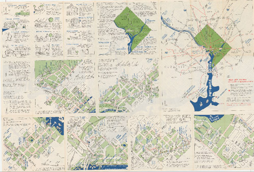
Image from DDOT.
Architecture firm John Wiebenson & Associates produced the map for the Bicentennial Commission of the District of Columbia.
Cross-posted at Greater Greater Washington.
Average Rating: 4.6 out of 5 based on 265 user reviews.
March 13th, 2015 | Permalink
Tags: bus, fun, history, maps, transportation
As marijuana legalization took effect in the District of Columbia, Mayor Muriel Bowser said DC would “not become like Amsterdam.” We talked about the differences yesterday, including on bicycling and transit, but the Embassy of the Netherlands has playfully responded with this infographic comparing our two capital cities.
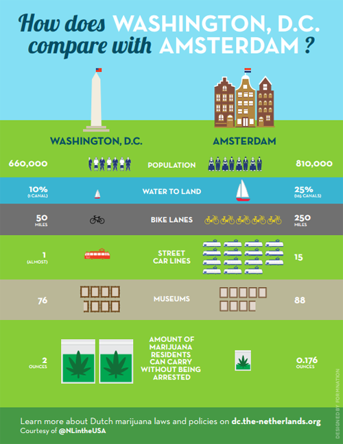
Image from the Dutch government. Really.
The embassy also created a Q&A comparing marijuana laws in the two cities. But bicycling and transit supporters might focus more on the bike lane and streetcar disparities.
That “(almost)” hurts. Low blow, Netherlands.
Cross-posted at Greater Greater Washington.
Average Rating: 5 out of 5 based on 248 user reviews.
February 27th, 2015 | Permalink
Tags: bike, fun, streetcar, transportation
Ottawans probably don’t get a lot of snow days off work. Not with winter commuting options like the Rideau skateway, a four mile long highway for ice skaters
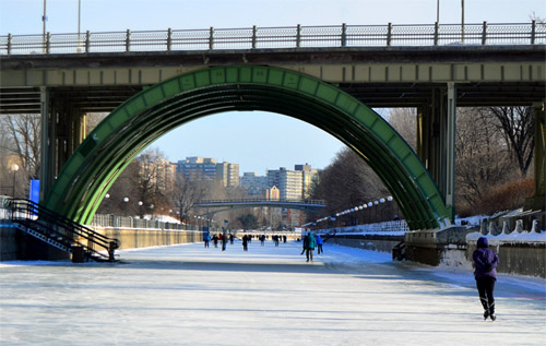
Rideau skateway. Photo by Ted Court on Flickr.
The skateway runs along the Rideau Canal, from downtown Ottawa to the south, cutting through some of Ottawa’s densest urban neighborhoods.
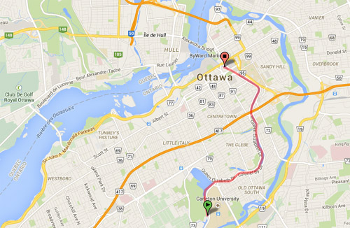
Rideau skateway. Basemap from Google.
During most of the year, Rideau Canal is liquid. It’s an actual, functioning canal. But in the winter it naturally freezes over, so Ottawans take advantage.
For the most part the skateway is recreational. Crowds of teenagers and happy couples play there, and advertisers bill it as the “world’s longest ice skating rink, ” not as a commuter route.
But at least one person commutes on it, and that’s such a cool idea that there are surely many others.
It’s almost enough to make you wish DC winters got a bit colder.
Cross-posted at Greater Greater Washington.
Average Rating: 4.5 out of 5 based on 271 user reviews.
January 27th, 2015 | Permalink
Tags: fun, parks, transportation
This is a world population cartogram, a false-geography map that resizes countries according to their population. It’s an interesting way to view the world, and compared to common projections perhaps more accurate, in its own way.
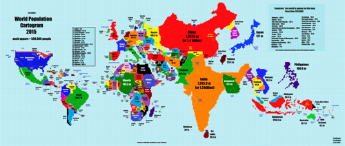
Map from Reddit user TeaDranks.
The United States is the world’s fourth largest country by land area, and third largest by population, so it’s not particularly distorted compared to geographic projections. But many other countries are.
China (1.4 billion) and India (1.3 billion) visually dominate, being by far the world’s two most populous countries. Others that stand out with seemingly oversized populations are Nigeria, Bangladesh, Japan, and the Philippines.
On the other end of the spectrum, the world’s two largest countries by land area are much reduced. Russia’s population of 146 million is still good enough for 9th highest globally, but that appears unimpressive against its normally huge area. And Canada, the world’s second largest country but only its 37th most populous, is nothing but a tiny sliver.
What stands out to you?
Cross-posted at Greater Greater Washington.
Average Rating: 4.4 out of 5 based on 151 user reviews.
January 26th, 2015 | Permalink
Tags: demographics, fun, maps
Washington’s I-495 beltway is a 64 mile long loop. London’s M-25 orbital motorway is 117 miles. They seem big, but they’re practically microscopic next to the greatest ring road on Earth, Australia’s 9, 000-mile Highway 1.
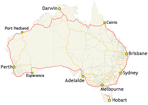
Map from the Commonwealth of Australia.
In fact, Highway 1 is the longest single highway in the world. It’s 32% longer than Russia’s Trans-Siberian Highway, and almost three times longer than the longest US Interstate, I-90.
The Australian government created Highway 1 in 1955, by compiling a network of existing local and regional highways under a single banner.
Unlike American Interstates, Highway 1 isn’t fully limited access for its entire length. Near big cities like Sydney or Melbourne it looks like an Interstate, but many sections in rural areas are simple two-lane roads, and some extremely isolated sections are even more basic.
All hail the king of ring roads.
Cross-posted at Greater Greater Washington.
Average Rating: 4.4 out of 5 based on 272 user reviews.
January 12th, 2015 | Permalink
Tags: fun, maps, roads/cars, transportation
Remember #bikeinbloom, when Capital Bikeshare dressed one of its bikes up in cherry blossom regalia? Every Christmas, Amsterdam does the same thing with one of its famous streetcars.
Amsterdamers call it the “kersttram”, or “Christmas tram.”
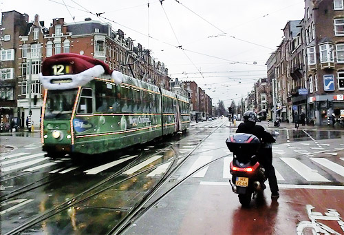
Photo from Alexander Meijer on Flickr.
Amsterdam isn’t alone. Other cities around the world partake in the same fun with their own trams. Among them: Budapest, Zurich, and San Francisco.
How about it, DDOT? Maybe next year, when H Street is finally up and running?
Cross-posted at Greater Greater Washington.
Average Rating: 4.5 out of 5 based on 178 user reviews.
December 18th, 2014 | Permalink
Tags: fun, streetcar, transportation
A public art installation on San Francisco’s Market Street will add animated lights following the movement of subway trains running directly below.
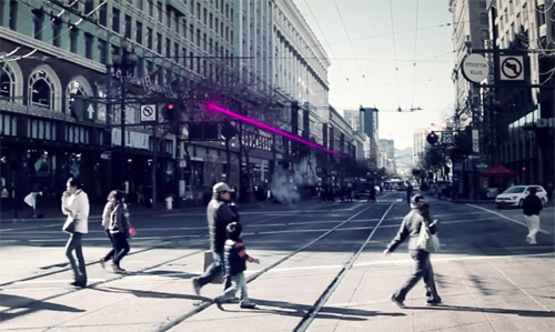
Image from Illuminate The Arts.
The project is called “LightRail, ” and according to its sponsors it will be the world’s first “subway-responsive light sculpture.”
Two LED strings will stretch above Market Street for two miles through downtown San Francisco. Using real-time arrival data, the strings will visualize movement of BART and Muni trains directly underneath the street.
Sponsors hope LightRail will open in 2015, and will remain in place until at least 2018. If it proves popular, officials may decide to keep it up longer.
Without a doubt, this is one of the coolest public art projects I’ve ever seen.
Cross-posted at Greater Greater Washington.
Average Rating: 5 out of 5 based on 153 user reviews.
December 17th, 2014 | Permalink
Tags: fun, lightrail, metrorail, transportation
These stills from the four minute film Wanderers beautifully show what human civilization might look like with colonies on Mars, in the asteroid belt, and on the moons of Jupiter, Saturn, and Uranus.
Cities on Saturn’s moon Iapetus. All images from Erik Wernquist’s Wanderers.
Though stunning, these images are not mere fantasies. They’re based on real scientific ideas about what a spacegoing civilization would likely look like, given foreseeable future technology.
The film is by Swedish artist Erik Wernquist, who draws inspiration from hard sci-fi author Kim Stanley Robinson’s Red Mars trilogy, as well as his novel 2312.
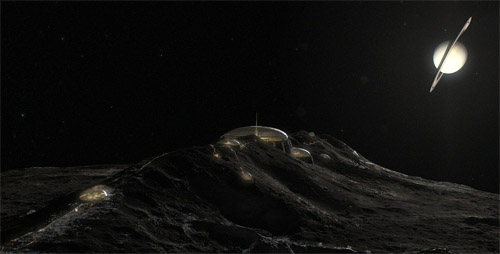
The first image, above, shows a series of domed settlements on Saturn’s icy moon Iapetus. Iapetus has a giant equatorial ridge that runs around the entire moon like an actual physical equator. The views of ringed Saturn from atop Iapetus’ ridge would be among the most dazzling in the solar system.

Bird suit fliers on Titan.
This second image shows another moon of Saturn, Titan, where the human-powered transportation equivalent to bicycling would be a bird suit.
Titan is larger than the planet Mercury, has rivers and oceans of liquid methane, and an atmosphere thicker than Earth’s. Its combination of thick atmosphere and low gravity would make it possible for humans to fly using nothing but strapped-on wings.

“Terraruim” colony, from a hollowed cylindrical asteroid.
This third image shows an O’Neill cylinder colony, or what Wernquist and Robinson call a “terrarium.” It’s a cylindrical hollowed out asteroid that astronauts have filled with an atmosphere and terraformed with a habitable landscape.
That may seem like a lot of effort, but for a spacegoing civilization asteroids offer many advantages, especially for transportation purposes. Their extremely low gravity makes launches and landings much easier than any planet or moon, while they still have enough raw materials to mine and export.
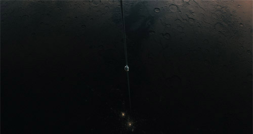
Martian space elevator.
This last image shows a space elevator ferrying people and goods between orbit and a brightly lit metropolis on the surface of Mars.
Space elevators would have to be tens of thousands of miles long, but would negate the need for expensive chemical rockets, making space vastly easier and cheaper to access.
They’re exactly the sort of revolutionary transportation system that could completely change how humanity organizes itself. Prosperous port cities would be sure to form at the base of any elevators ever built, like futuristic New Yorks at the mouth of a celestial Hudson River.
Amazingly, space elevators are not that far-fetched. Scientists understand elevators’ physics well enough that they may be buildable within the next century.
Be sure to watch the four-minute film, and check out Wernquist’s gallery for more of these beautiful images.
Cross-posted at Greater Greater Washington.
Average Rating: 4.4 out of 5 based on 254 user reviews.
December 2nd, 2014 | Permalink
Tags: fun, master planning, proposal, transportation
For Veteran’s Day festivities today, Metro is running an unusual service pattern, with no Blue Line. It’ll be rough for commuters, but neat for transit nerds. Why? Say hello to the Pink Line, for one day only.
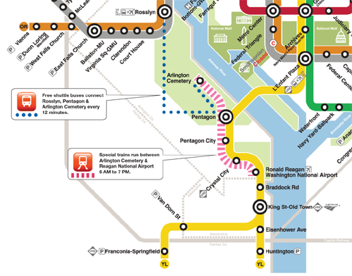
“Special trains” between Arlington Cemetery and National Airport, illustrated with pink. Original image from WMATA.
Without regular Blue Line trains, Metro is running this special Pink Line to provide service to Arlington Cemetery, which otherwise wouldn’t have any trains.
The map doesn’t actually include the words “Pink Line” anywhere, and trains running this route will probably simply be labelled “Special, ” without any color.
But the map shows pink, so I think we can claim it.
Cross-posted at Greater Greater Washington.
Average Rating: 4.9 out of 5 based on 204 user reviews.
November 11th, 2014 | Permalink
Tags: fun, metrorail, transportation
|
Media


Site
About BeyondDC
Archive 2003-06
Contact
Category Tags:
Partners
|


_map.png)


