|
Special Features


Image Libraries


|
|
Blog
The Beltway HOT lanes are officially open and in action. I went out yesterday afternoon to take a quick look, although I still haven’t driven on them.
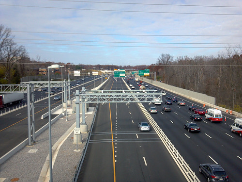
I-495 HOT lanes, at Lee Highway.
In this picture you’re looking north along I-495 from the US-29 overpass, in Merrifield. The metallic contraption hanging over the highway in the center of the image is the toll gantry, which reads EZpass signals from passing cars below. You must have an EZpass to use the lanes.
There is exactly 1 car visible using the HOT lanes in either direction, although the picture wasn’t taken during rush hour.
It will be especially interesting to see if these new express lanes help a transit culture develop in Tysons Corner. Tysons has more office space than downtown Baltimore, so there’s plenty of potential market. Buses will use the lanes on routes coming from Fairfax, Loudoun, and Prince William counties, and will undoubtedly have a better trip than they would in the general purpose lanes. But with a private company that hopes to maximize toll revenue in charge of the lanes, one wonders how well buses will be treated.
One thing is totally clear: There will still be traffic jams on the Beltway. HOT lanes will allow some drivers and transit users to bypass congestion, but if there aren’t traffic jams then no one would pay to use the HOT lanes, so the road’s owners wouldn’t make any money. The concept requires continued congestion in the general purpose lanes in order to work.
These things give people more options, so that’s good, but they won’t end congestion on the Beltway.
Average Rating: 4.8 out of 5 based on 212 user reviews.
November 20th, 2012 | Permalink
Tags: bus, events, roads/cars, transportation

There has got to be a better way to hide fabric stains than the Saved by the Bell aesthetic.

Seriously though, let’s credit WMATA for not using this so much recently.
Image from reddit.
Average Rating: 4.7 out of 5 based on 243 user reviews.
November 8th, 2012 | Permalink
Tags: bus, fun, transportation
Last year about this time I visited Seattle, Portland, and Vancouver. I prepared a slideshow of transportation photos from the three cities to share with coworkers. It’s essentially a tour of rail, bus, and bike infrastructure within each city. Why not share it here too?
Click the image to download a pdf of the slideshow. It’s about 16 Mb. If you just want to see the photos in flickr without commentary, here they are.
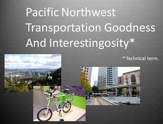
Click to download pdf.
Average Rating: 4.7 out of 5 based on 283 user reviews.
October 16th, 2012 | Permalink
Tags: bike, boat, BRT, bus, commuterrail, galleries, intercity, lightrail, streetcar, transportation
Usually when it comes to dedicated street lanes for transit and bicycles, the more physical separation from car lanes there is, the better off you are. Better physical separation is why cycle tracks are better than regular bike lanes, and why busways are better than striped bus lanes.
Unfortunately, physical separation adds complexity and cost, so it’s not used as often as it might be.
That in mind, take a look at this picture from Guadalajara, Mexico, where a very affordable measure of physical separation has been added to a bus lane:

Photo by SoCalMetro on flickr.
This solution wouldn’t work in a lot of places for a lot of reasons, and even where it would work it isn’t as good as the expensive heavily-engineered options. But nevertheless it’s a cheap way to squeeze some separation into some bus lanes. It’s worth considering, wherever there isn’t a need for cars to cross over the bus lane, and where a more expensive solution isn’t practical.
The first cycle tracks in the US were heavily engineered and expensive, but we quickly learned that they needn’t be. Maybe it’s time to ask whether that same lesson can apply to busways.
Average Rating: 4.5 out of 5 based on 182 user reviews.
October 4th, 2012 | Permalink
Tags: BRT, bus, transportation, urbandesign
|
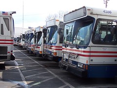
Buses at WMATA’s old Ballston bus yards, which has since been closed and redeveloped. |
Here’s a simple fact of bus planning: You can only run as many buses during the day as you can park at night. Want to expand service but your bus parking lot is at capacity? Then sorry, too bad, can’t do it.
This simple issue drives bus operations as much as just about any other planning issue. Not only do you need big parking lots with maintenance garages attached, but they need to be geographically close to the bus routes they serve, because otherwise it costs too much to drive empty buses and drivers changing shifts back and forth from the parking depot to their routes.
In the transit supportive core of the Washington region, where bus ridership is booming and land is getting more and more expensive, the availability of bus parking is very probably the largest constraint on expansion of bus services. Multiple WMATA bus yards have been closed in recent years, claimed by high-density redevelopment near the baseball stadium and in Ballston.
So it’s a pretty big deal that last week WMATA opened a new bus storage yard, its first since 1989. The new Shepherd Parkway Metrobus Division is in Southwest DC and will house up to 250 buses, most of which will serve routes in SW and SE DC.
In the long term, improvements like this are the necessary ground work for the more interesting things that can happen later as a result, such as new bus routes, improved frequencies, and more high-capacity articulated buses. Good work, WMATA.
Average Rating: 4.5 out of 5 based on 179 user reviews.
October 1st, 2012 | Permalink
Tags: bus, development, transportation
|
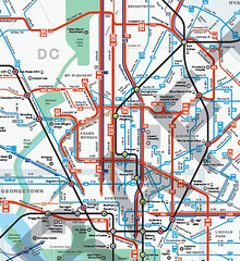
Central DC in WMATA’s new map. |
WMATA’s new bus maps are, in a word, awesome. They are so good, on so many levels. They will make navigating the bus system vastly easier, and less intimidating. But WMATA asked for comments, so I’ll make some.
What’s better
The main problem with WMATA’s old bus maps were that they were so complex that reading them was essentially impossible. WMATA has so many criss-crossing bus routes, all illustrated identically, that riders had to already be familiar with a bus route in order to use the maps. That dissuaded a lot of people from using WMATA buses, or from using them more extensively.
The main improvement of these new maps is that everything looks simpler. Individual routes are vastly easier to follow, thanks to more variety in line color, thickness, and improved spacing.
The best single new feature is that the best bus routes are highlighted with a thicker line, so it’s easier for riders to find the routes that are most convenient. This is exactly the reason why I published my own 15 minute bus map earlier this year. WMATA’s new maps are better than my version though, because they offer so much more information while still clearly highlighting the frequent network.
WMATA’s PlanItMetro blog has several further examples of how these new maps are more clear. For example, compare how the old and new maps illustrate the area around Greenbelt Metro station:
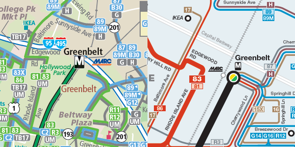
Old on the left, new on the right.
Good luck reading the version on the left.
What needs improvement
There are two big problems with the details of how these maps highlight the best routes.
The first is that some of the best bus routes in the region are hard to find on the maps. DC Circulator, Bethesda Circulator, and the King Street “trolley” shuttle all offer extremely good service, but are shown as minor routes on the map because they aren’t run by WMATA.
Failing to show non-WMATA buses in a fair way is a disservice to riders, and is counterproductive to the goal of encouraging overall transit ridership. WMATA exists in order to serve the needs of the DC region. What’s most important is a complete picture of transit services, regardless of who operates them. Self-serving parochialism should not be WMATA’s mindset.
The second problem with the way the new maps highlight good routes is that the standards for what qualifies as a highlighted route in Northern Virginia are too low. This unnecessarily clutters the Northern Virginia map, and doesn’t give riders accurate information.
Here’s part of the Northern Virginia map. There are so many thick red lines that it’s very difficult to follow them, which defeats the point of having them in the first place.
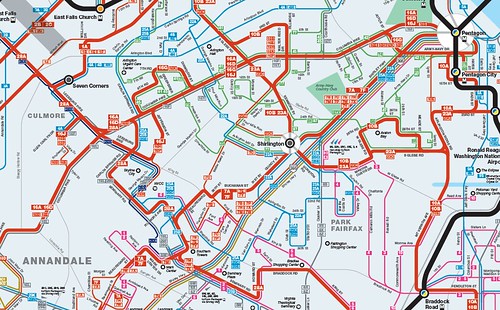
Northern Virginia, too cluttered.
Some of those “frequent” bus routes only come every 1/2 hour at off-peak times of day. Some of the others are branches that should be shown with a thin red line. Meanwhile the 9S, which is one of the most frequent routes in Virginia, doesn’t have a line at all.
Compare that Northern Virginia map with the Montgomery County version, which shows highlighted thick red routes much more clearly. The standards for a thick red line on the Montgomery County map are tight enough to keep them clear. The standards on the Virginia map are too low, resulting in a cluttered and less usable map.
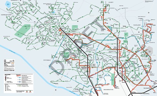
Montgomery County. The right half is good, but the left half needs work.
On the other hand, the Montgomery map has another problem. Look at Gaithersburg and Germantown, which take up the left half of that map. All the routes there are shown with the same kind of line because they’re all pretty similar, but that makes them hard to tell apart on the map. And since Gaithersburg and Germantown have twisty suburban streets rather than planned grids, the new map’s geographic distortion makes it harder rather than easier to read.
Recommendations
1. Add a middle thickness line weight and use it to highlight non-WMATA frequent routes, as well WMATA routes in the suburbs that need to be called out as “major”, but that don’t offer really frequent service. This will better illustrate the important non-WMATA routes, and improve the visual hierarchy in suburban areas, which are currently shown with either too many or too few highlighted routes. This will also better inform riders about the quality of routes.
2. Add more geographic clues in areas with a lot of homogenous routes that are difficult to distinguish, such as Gaithersburg and Germantown.
3. Add names to MARC and VRE station labels.
4. Make a single regional map available. There are good reasons to keep separate maps for DC, Montgomery, Prince George’s, and Virginia, but there’s no good reason not to publish a single overall map as well.
5. A really great next step would be to make these interactive maps, instead of pdfs. I’d love to be able to see individual routes highlighted separately whenever I hover my cursor on them, and then go to the timetable with a click.
Send WMATA your own comments
To make sure WMATA planners read your thoughts, leave them in the comments section of the PlanItMetro blog.
Average Rating: 4.5 out of 5 based on 195 user reviews.
September 27th, 2012 | Permalink
Tags: bus, maps, proposal, transportation
Starting today, Greyhound and Peter Pan buses that have traditionally used their own bus station at 1st and L St, NE will instead use the Union Station garage. The 1st and L site was sold for redevelopment, so the bus station building there will soon be no more.
It’s doubtful that anyone will shed a tear for the old bus station, which has about as poor a street presence as a transit station could possibly have, and which is obviously an under-use of its downtown land. But still, a transit station is a transit station, and I love transit stations. So bad as the building’s reputation may be, I do regret never visiting the place before it lost its transit.
Having never been inside, and being curious, I asked on twitter if anyone has photos of the place. Luckily, NoMa ANC Commissioner Tony Goodman was there today for the closing, and responded with a picture, copied below. Thanks Tony!
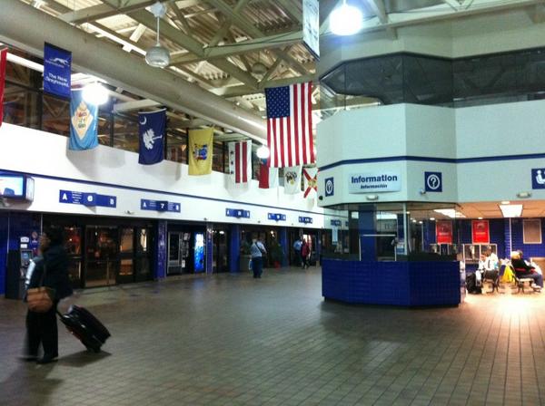
Bus station interior. My curiosity is satisfied.
Average Rating: 4.9 out of 5 based on 164 user reviews.
September 26th, 2012 | Permalink
Tags: architecture, bus, intercity, preservation, transportation
|

DDOT’s options for transit lanes or cycle tracks on M Street. Why not both? |
Last week DDOT released its initial study of alternatives for M Street SE/SW. The study identifies 3 options for how the street might be redesigned, including options that include dedicated transit lanes and cycle tracks. However, none of DC’s options include both transit lanes and cycle tracks.
In a joint editorial published today at Greater Greater Washington, David Alpert and I discuss why DDOT used this strategy, and how the next round of planning can and should combine aspects of the existing 3 alternatives to form new and better multimodal options.
>> Go to GGW and read the editorial.
(Link fixed.)
Average Rating: 4.6 out of 5 based on 268 user reviews.
September 18th, 2012 | Permalink
Tags: bike, bus, development, metrorail, proposal, roads/cars, streetcar, transportation, urbandesign
Back in 2010, WMATA produced a 15-minute bus map that showed bus routes with frequent service throughout the day. That map was just for planning purposes, but it’s such a useful idea that I took the next step, and turned it into a more user-friendly diagram.
In addition to Metrobus routes, this map also shows other frequent bus services in the region, including DC Circulator, Bethesda Circulator, and the King Street Trolley.
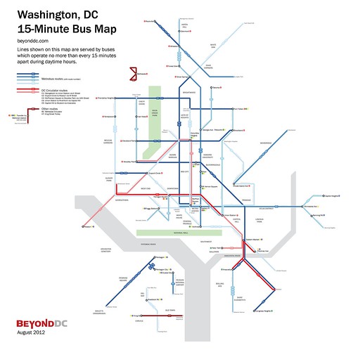
 Cross-posted at Greater Greater Washington. Cross-posted at Greater Greater Washington.
Average Rating: 4.7 out of 5 based on 157 user reviews.
August 10th, 2012 | Permalink
Tags: bus, featured post, maps, transportation
|
Media


Site
About BeyondDC
Archive 2003-06
Contact
Category Tags:
Partners
|


