|
Special Features


Image Libraries


|
|
Blog
|
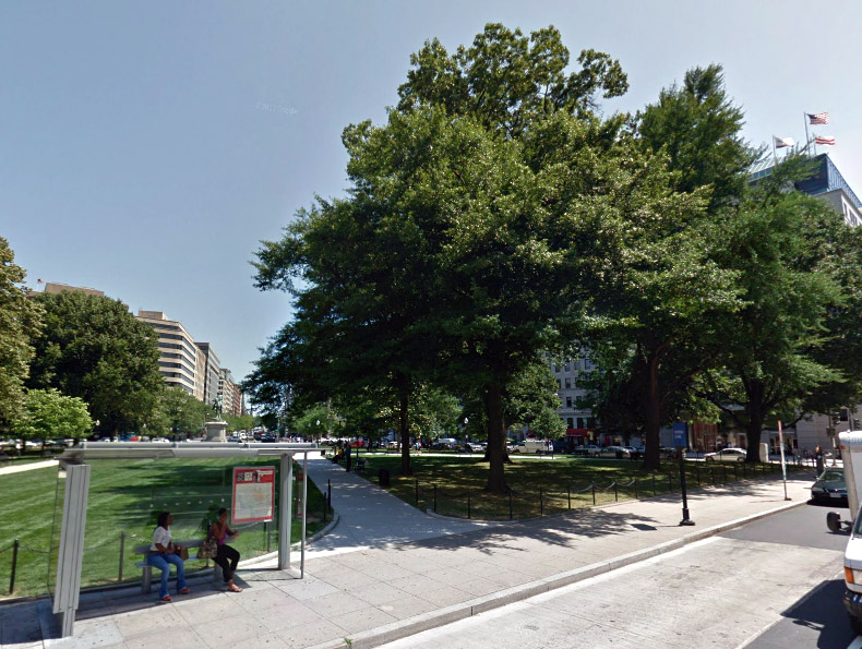
McPherson Square. Image from Google Street View. |
Sometime earlier this month the National Park Service finally removed its fences from McPherson Square. The fences had been blocking access to most of the park for about the same length of time that Occupy DC had its tents there.
Occupy DC first started using McPherson Square in October, 2011. By January, 2012 they covered the entire park, but in February the majority of campers were removed. Some tents remained until June. In total, Occupy’s tents were up in McPherson Square for about 8 months, with the heaviest concentration lasting only about 3 months.
Shortly after booting Occupy from McPherson Square, the National Park Service fenced off all the grassy portions of the square, so they could regrow grass. The grass was back by late summer 2012, but the fences remained until just recently. They were up, completely blocking anyone from using most of the park, for about 8 months. That’s as long as Occupy used the park, and more than twice as long as Occupy’s full strength.
And of course, Occupy didn’t stop anyone from using the park the way NPS did. Occupy was there, in the way, but they didn’t put up fences. Occupy never tried to physically stop other people from using McPherson Square.
This NPS “fix” was worse than the “problem”, and was the latest illustration of how NPS prioritizes grass above the people who actually use their parks.
For years NPS has managed DC’s urban parks like Yellowstone or Yosemite, treating them like nature preserves instead of social places for people. They have gotten a little better in recent years, with new leadership in charge of DC park lands, but obviously much improvement is still needed.
Average Rating: 4.5 out of 5 based on 275 user reviews.
February 28th, 2013 | Permalink
Tags: government, parks

Denver is in the midst of a huge regional rail expansion. That’s great, but like in many cities (including DC, historically), the urban bus system has been largely ignored amidst all the hubbub over rail.
I got my planning degree at the University of Colorado, and after discussing Denver’s bus system with some friends recently, decided to produce this map. It shows the city’s high-frequency bus routes along with its existing and future rail lines.
Although the geography is obviously different, in many ways this map is a sequel to my DC 15-minute bus map from last August. I applied a lot of the lessons learned during that exercise to this Denver map. Compared to the DC version this map shows more information, presented more cleanly.
Read more at DenverUrbanism.com.
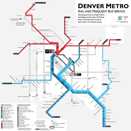
Denver rail and frequent bus map, including future lines. Click map for full size version.
Other sizes via flickr.
Average Rating: 5 out of 5 based on 242 user reviews.
February 27th, 2013 | Permalink
Tags: BRT, bus, commuterrail, lightrail, maps, streetcar, transportation
If Maryland’s legislature fails to raise new transportation funding this year, the Purple Line light rail, Baltimore Red Line subway, and Corridor Cities Transitway BRT could all be cut or seriously delayed.
While reading a report about the Corridor Cities Transitway, I stumbled on these renderings of two of its more important stations. The first shows King Farm, near Shady Grove Metro, and the second shows Metropolitan Grove, a TOD in Gaithersburg where the CCT will meet an existing MARC station.
Note the relatively simple brick stop shelters, especially.
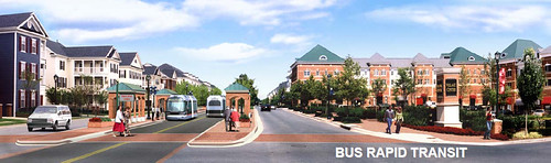
King Farm station.
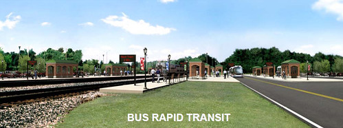
Metropolitan Grove station, showing MARC on the left.
Average Rating: 4.5 out of 5 based on 259 user reviews.
February 26th, 2013 | Permalink
Tags: architecture, BRT, funding, government, transportation
|
K Street Transitway. Image by DDOT. |
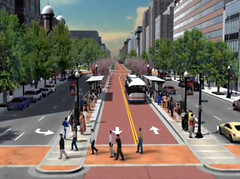
DDOT is studying whether or not to extend the H Street streetcar onto K Street in downtown DC. As part of the study, they will rethink whether or not the long-planned K Street Transitway makes sense.
DC’s citywide streetcar plan shows a line connecting H Street with downtown and Georgetown, roughly along the same route as the K Street Circulator bus. With H Street less than a year from opening, it’s now time to start working on the next project.
On Wednesday evening last week, DDOT kicked off its new Union Station to Georgetown Transit Alternatives Analysis. It will consider extending the streetcar versus using other modes such as BRT. It will also look at whether to pursue the transitway or some other alternative.
In order to gain federal approval, and possibly get funding, DC has to study all the options. Streetcars will be strongly considered since existing streetcar plans are the impetus for the study, but rail is not a foregone conclusion.
The study will also look at K Street itself. For years DDOT has proposed rebuilding K Street to include a physically separated transitway down its center. The transitway hasn’t been built yet because there’s never been funding. It’s at least a $140 million project, not counting any of the tracks or electric power systems necessary for streetcars.
The transitway is still an option, but as part of the Alternatives Analysis DDOT will also look at other possibilities, such as curbside transit lanes, mixed traffic, and maybe even using other streets for more transit trips.
The analysis will also consider how to connect Georgetown. Traditional options will focus on Pennsylvania Avenue, M Street, and K Street underneath the Whitehurst Freeway, but a more radical idea might be to convert the Whitehurst itself to a more multimodal, complete street.
If you have any ideas you think DDOT should consider, you can contact them via the project webpage.
Average Rating: 4.4 out of 5 based on 251 user reviews.
February 25th, 2013 | Permalink
Tags: BRT, streetcar, transportation
WMATA is considering 2 options to add more rush hour service to the 16th Street bus line near downtown. One option would start at either U Street or V Street, and the other would extend up Meridian Hill to Euclid Street.
WMATA’s two options for a new “short turn” 16th Street bus. Image by WMATA.
The 16th Street buses are overcrowded along the southern part of the S-series Metrobus line in the morning rush. Riders hoping to catch a bus south of Columbia Heights frequently watch one bus after another pass by without stopping, too full to take on any new passengers.
WMATA head bus planner Jim Hamre and his team presented the new route options at a meeting last night organized by Dupont ANC commissioner Kishan Putta.
Both options begin around Meridian Hill, serve all bus stops along 16th Street from there to Lafayette Park, and then run back north without stopping, in order to start over as quickly as possible.
Frequency versus coverage
WMATA only has 2 buses available to run this service, so the options present a choice of high frequency versus greater coverage.
The first option, on the left, is the easiest to operate and provides the greatest frequency. Buses in the morning rush hour would come every 15 minutes, in addition to the existing bus service. But the line would end at either U or V Street, and the crowding problems start farther north.
The second option, on the right, extends up Meridian Hill to Euclid Street. This would reach more passengers, but adds time and complication. Buses would only be able to run every 20 minutes at best. They would also get delayed more often because the streets around Meridian Hill are only a single lane and are often blocked by other vehicles.
Another potential complication for the second option is how buses would get back north. While northbound buses for the U/V Street option could use 14th Street, the only way to keep even 20 minute headways for the Euclid Street option would be to run northbound using 15th Street. 15th Street doesn’t currently have any buses, so residents there may have concerns.
Interestingly, Hamre said the worst crowding problems only appear during the morning rush, so this new supplement may only run in the morning. Evening rush hour buses are crowded too, but less excessively so. Riders aren’t usually being left behind in the evening.
There was widespread consensus at the meeting to support a rush hour supplement, but residents disagreed over which option is better. Eventually WMATA may be able to add service farther north and still provide good frequencies, but they’ll need more buses and more money to do it. In the meantime, they have to make do with only 2 buses, which means trade-offs.
Either way, riders on 16th Street should benefit. Even those from farther north should see improved service, since the buses they’re already on will move faster near downtown.
Theoretically the new route will be called the S3, although Hamre didn’t commit to that last night.
If everything goes smoothly, the new buses could roll down 16th Street as early as March 24. If there are delays then it could take longer.
Ultimately, Hamre said, WMATA also hopes to start “headway scheduling” on 16th Street. That means they would try to keep buses a certain distance apart rather than meet a predefined schedule. That works for Circulator buses, and for the 70s and 90s series Metrobuses, but it will take longer to implement, and is being considered a separate issue.
 Cross-posted at Greater Greater Washington. Cross-posted at Greater Greater Washington.
Average Rating: 4.7 out of 5 based on 198 user reviews.
February 21st, 2013 | Permalink
Tags: bus, transportation
|
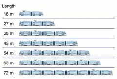
Image from the American Public Transportation Association. |
Streetcars and buses have different strengths and weaknesses, and are better at accomplishing different goals. Flexibility is often touted as a major strength of buses. Although buses are legitimately more nimble in some ways, when it comes to flexibility of capacity it’s streetcars that have the edge.
It’s true that buses have tremendous routing flexibility. Since buses can operate on any normal traffic lane, routes can be reconfigured on a whim and individual buses are free to move around obstacles. These are real benefits, and sometimes they determine that a route should use buses.
At the same time, streetcars are customizable for high-capacity service in ways that aren’t available for buses.
Streetcars can be longer
In simplest terms, streetcars can be longer than buses. Since streetcars run on tracks there is no danger of jackknifing. Likewise, since streetcars are powered by overhead wire there’s not a single engine distributing power. Thus there’s no physical limit to their length.
For example, streetcar manufacturer CAF offers its Urbos model in options ranging from 60 feet long up to 141 feet long. Bombardier’s similar Flexity model comes in any length from 69 feet up to 148 feet.
Portland’s famous streetcar is a relatively diminutive 65 feet long, but longer vehicles are beginning to show up in North America. Cincinnati is using a 77 foot long Urbos for its future line, and the first 78 foot long Siemens S70s have already been delivered to Atlanta. In Toronto, 99 foot long Flexities will soon ply the continent’s largest streetcar network.
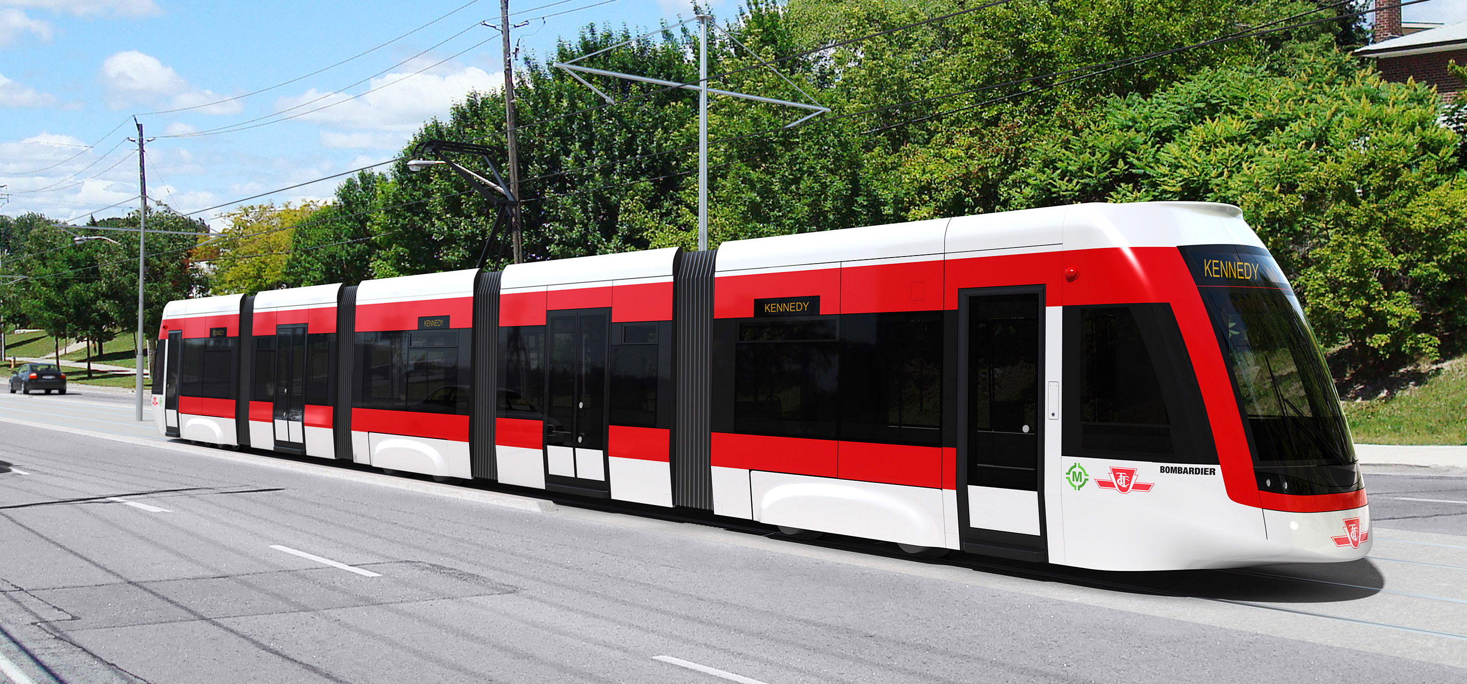
99′ long Toronto streetcar. Image by Bombardier.
And that’s just single streetcar vehicles. Streetcars can also be coupled into trains of multiple cars, so transit agencies that have shorter vehicles can still get the benefits of extra length without needing new railcars.
Agencies that want to run longer trains do have to provide longer stations, but since streetcar stations are typically simple, that’s relatively easy to accomplish.
Ultimately the limiting factor on streetcar length is the size of city blocks. Streetcars can’t typically be longer than one city block, lest they block traffic on perpendicular streets. But city blocks are usually hundreds of feet long, so streetcars can still be much longer than buses.
Streetcars can have diverse interiors
Even compared to buses of exactly the same length, streetcars can support a higher passenger capacity. Since gliding along rails is so much more smooth than rumbling along asphalt, and since there’s no need for huge wheel wells, it’s more practical for streetcars to have a lot of open space that maximizes standing capacity.
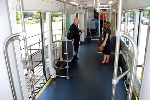
Interior of one of DC’s streetcars.
The 3 streetcars that DC has in storage use this strategy. They’re 65 feet long, but they have much more capacity than a 60 foot long articulated bus because of the open floor plan. The trade off, of course, is that they have fewer seats, but only streetcars practically offer the choice.
What kind of flexibility is more important?
Faced with the choice of operational flexibility or capacity flexibility, which one rules?
Obviously it depends on the needs of the corridor and the goals of the transit line. Sometimes buses are the correct answer, and other times it’s streetcars.
Sometimes it might make sense to use both on the same corridor. For example, streetcars capable of providing very high capacity might serve most passengers along a line, while buses capable of skipping around traffic might serve longer express trips on the same road.
There are 157 WMATA bus routes in the District of Columbia alone, with hundreds more WMATA and non-WMATA routes around the region. The majority of them are probably better served with buses, but some of them are undoubtedly better fits for streetcars.
The key for decision makers is to embrace the differences inherent to each mode, and decide accordingly.
Cross-posted at Greater Greater Washington.
Average Rating: 4.9 out of 5 based on 151 user reviews.
February 20th, 2013 | Permalink
Tags: streetcar, transportation
WashCycle reports today that the proposed 9th Street cycle track isn’t going to happen, because it is being removed from the regional long term plan. Fortunately, that’s incorrect.
I’ve spoken with DDOT about this, and they explain that the cycle track is still planned, and is simply being removed from the regional document because it doesn’t have to be listed there. The purpose of the regional plan is to model air pollution, and DDOT’s concept for the cycle track won’t impact the pollution computer model enough to bother with the added bureaucracy of keeping it in the plan.
Ironically, taking the cycle track out of the regional plan will actually make it easier to deliver, because it will reduce the number of bureaucratic hoops DDOT has to jump through in order to make the project happen.
Welcome to the confusing world of federal transportation reporting requirements!
Average Rating: 5 out of 5 based on 234 user reviews.
February 20th, 2013 | Permalink
Tags: bike, government, transportation
In late April Denver will open its newest light rail line. Most of the line runs on the surface through an old railroad right-of-way, but a few key segments are elevated above important street crossings. One such crossing, at Wadsworth Boulevard, includes this station directly atop the overpass.
The overpass bed looks like pretty typical highway infrastructure, but the station itself is light, airy, even beautiful. It’s not overwhelming, but is an undeniable and attractive landmark.
Light rail stations are much less substantial than heavy rail stations, so it’s not exactly fair to compare this to the relatively hulking Tysons Corner Silver Line stations. Light rail doesn’t need a mezzanine, and the deck doesn’t have to hold up as much weight. Regardless, a good example is a good example.
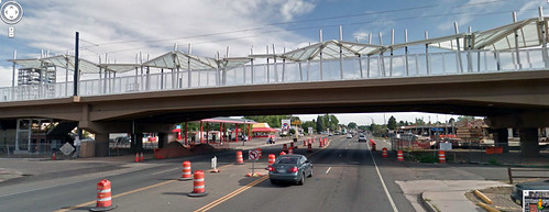
Image from Google Street View.
More photos of this station are at DenverUrbanism.
Denver is in the midst of a huge regional transit expansion program, resulting in several striking new stations. In November I posted about its awesome Union Station train shed, and its airport station is equally impressive.
Average Rating: 4.6 out of 5 based on 281 user reviews.
February 19th, 2013 | Permalink
Tags: architecture, lightrail, transportation
|
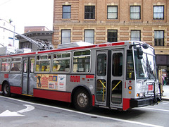
SF Muni bus. |
How do you stop car drivers from blocking bus lanes? Put cameras on buses, of course.
Unfortunately, transit lanes are often clogged by car drivers who either don’t know or don’t care that cars are not allowed in them. Enforcement is difficult, because violation is often so rampant that it’s not practical for the police to pull over every violating car.
DC’s 7th Street bus lane through Chinatown is a prime example.
But there is a solution. San Francisco is installing cameras on all its city buses, specifically to enforce the prohibition on cars in transit lanes. Human officers will review footage from the cameras and mail tickets to the owners of any cars illegally blocking the lane.
Bus cameras in San Francisco will not be used to ticket other types of moving violations such as speeding or running red lights. For now they won’t even be used to ticket car drivers that block bus stops. Current law prohibits any use other than ticketing transit lane violations.
Even that limited application will make a big difference, though. San Francisco has 17 miles of transit lanes, but without enforcement they’re no better at actually moving buses through traffic than 7th Street in DC.
If this idea works it could have a huge effect on bus planning nationwide. Bus lanes could become much more effective, and therefore likely to become more widespread.
Cross-posted at Greater Greater Washington.
Average Rating: 4.4 out of 5 based on 177 user reviews.
February 15th, 2013 | Permalink
Tags: bus, roads/cars, transportation
This picture of Boston was taken by an American Airlines pilot shortly after the blizzard last weekend.
DC, on the other hand, is in the midst of its least snowy 2 year period on record, which comes shortly after our own 2010 snowpocalypse. But that’s OK. Extreme weather all the time probably isn’t climate change, right? Gotta be a hoax.
Boston in the snow. Image from reddit.
Average Rating: 4.9 out of 5 based on 217 user reviews.
February 14th, 2013 | Permalink
Tags: environment
|
Media


Site
About BeyondDC
Archive 2003-06
Contact
Category Tags:
Partners
|


