Special Features

Image Libraries

Blog

My favorite street space from Park(ing) Day comes from Dallas, which took the event very seriously. Chairs and little patches of grass are nice, but I love the creative thinking that resulted in a book exchange:


Photo by C Troy Mathis on flickr.

Average Rating: 4.9 out of 5 based on 225 user reviews.

September 28th, 2012 | Permalink
Tags: events, fun, urbandesign


click for full pdf map
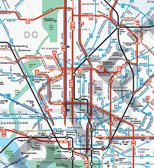
Central DC in WMATA’s new map.

WMATA’s new bus maps are, in a word, awesome. They are so good, on so many levels. They will make navigating the bus system vastly easier, and less intimidating. But WMATA asked for comments, so I’ll make some.

What’s better

The main problem with WMATA’s old bus maps were that they were so complex that reading them was essentially impossible. WMATA has so many criss-crossing bus routes, all illustrated identically, that riders had to already be familiar with a bus route in order to use the maps. That dissuaded a lot of people from using WMATA buses, or from using them more extensively.

The main improvement of these new maps is that everything looks simpler. Individual routes are vastly easier to follow, thanks to more variety in line color, thickness, and improved spacing.

The best single new feature is that the best bus routes are highlighted with a thicker line, so it’s easier for riders to find the routes that are most convenient. This is exactly the reason why I published my own 15 minute bus map earlier this year. WMATA’s new maps are better than my version though, because they offer so much more information while still clearly highlighting the frequent network.

WMATA’s PlanItMetro blog has several further examples of how these new maps are more clear. For example, compare how the old and new maps illustrate the area around Greenbelt Metro station:


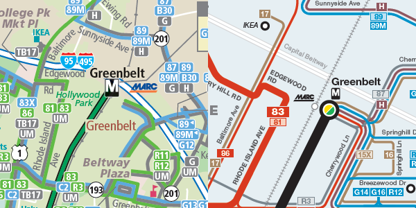
Old on the left, new on the right.

Good luck reading the version on the left.

What needs improvement

There are two big problems with the details of how these maps highlight the best routes.

The first is that some of the best bus routes in the region are hard to find on the maps. DC Circulator, Bethesda Circulator, and the King Street “trolley” shuttle all offer extremely good service, but are shown as minor routes on the map because they aren’t run by WMATA.

Failing to show non-WMATA buses in a fair way is a disservice to riders, and is counterproductive to the goal of encouraging overall transit ridership. WMATA exists in order to serve the needs of the DC region. What’s most important is a complete picture of transit services, regardless of who operates them. Self-serving parochialism should not be WMATA’s mindset.

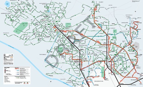
The second problem with the way the new maps highlight good routes is that the standards for what qualifies as a highlighted route in Northern Virginia are too low. This unnecessarily clutters the Northern Virginia map, and doesn’t give riders accurate information.

Here’s part of the Northern Virginia map. There are so many thick red lines that it’s very difficult to follow them, which defeats the point of having them in the first place.


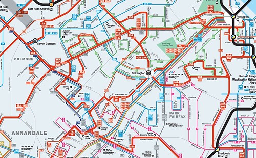
Northern Virginia, too cluttered.

Some of those “frequent” bus routes only come every 1/2 hour at off-peak times of day. Some of the others are branches that should be shown with a thin red line. Meanwhile the 9S, which is one of the most frequent routes in Virginia, doesn’t have a line at all.

Compare that Northern Virginia map with the Montgomery County version, which shows highlighted thick red routes much more clearly. The standards for a thick red line on the Montgomery County map are tight enough to keep them clear. The standards on the Virginia map are too low, resulting in a cluttered and less usable map.


Montgomery County. The right half is good, but the left half needs work.

On the other hand, the Montgomery map has another problem. Look at Gaithersburg and Germantown, which take up the left half of that map. All the routes there are shown with the same kind of line because they’re all pretty similar, but that makes them hard to tell apart on the map. And since Gaithersburg and Germantown have twisty suburban streets rather than planned grids, the new map’s geographic distortion makes it harder rather than easier to read.

Recommendations

1. Add a middle thickness line weight and use it to highlight non-WMATA frequent routes, as well WMATA routes in the suburbs that need to be called out as “major”, but that don’t offer really frequent service. This will better illustrate the important non-WMATA routes, and improve the visual hierarchy in suburban areas, which are currently shown with either too many or too few highlighted routes. This will also better inform riders about the quality of routes.

2. Add more geographic clues in areas with a lot of homogenous routes that are difficult to distinguish, such as Gaithersburg and Germantown.

3. Add names to MARC and VRE station labels.

4. Make a single regional map available. There are good reasons to keep separate maps for DC, Montgomery, Prince George’s, and Virginia, but there’s no good reason not to publish a single overall map as well.

5. A really great next step would be to make these interactive maps, instead of pdfs. I’d love to be able to see individual routes highlighted separately whenever I hover my cursor on them, and then go to the timetable with a click.

Send WMATA your own comments

To make sure WMATA planners read your thoughts, leave them in the comments section of the PlanItMetro blog.

Average Rating: 4.8 out of 5 based on 260 user reviews.

September 27th, 2012 | Permalink
Tags: bus, maps, proposal, transportation


Starting today, Greyhound and Peter Pan buses that have traditionally used their own bus station at 1st and L St, NE will instead use the Union Station garage. The 1st and L site was sold for redevelopment, so the bus station building there will soon be no more.

It’s doubtful that anyone will shed a tear for the old bus station, which has about as poor a street presence as a transit station could possibly have, and which is obviously an under-use of its downtown land. But still, a transit station is a transit station, and I love transit stations. So bad as the building’s reputation may be, I do regret never visiting the place before it lost its transit.

Having never been inside, and being curious, I asked on twitter if anyone has photos of the place. Luckily, NoMa ANC Commissioner Tony Goodman was there today for the closing, and responded with a picture, copied below. Thanks Tony!


Bus station interior. My curiosity is satisfied.

Average Rating: 4.7 out of 5 based on 231 user reviews.

September 26th, 2012 | Permalink
Tags: architecture, bus, intercity, preservation, transportation


When the Baltimore Red Line is built, it will include 5 subway stations through the central city. Earlier this month Maryland’s project planners released renderings of what the subway portals will look like, reproduced below.

It sure will be great when Baltimore has a better transit system.

Average Rating: 4.5 out of 5 based on 265 user reviews.

September 25th, 2012 | Permalink
Tags: lightrail, transportation, urbandesign


click to enlarge
Arlington, urbanizing.

Salon.com recently interviewed me for a story about emerging suburban downtowns. Here are some snippets:

Fact: People want to live in walkable urban places. Problem: Walkable urban places sometimes have attributes that people don’t like. Solution: Build new walkable urban places out in the suburbs. Result: A whole new type of place that offers the city experience without the actual city…

Some of them are in places like Rosslyn and Bethesda — close-in suburbs that developed an organic urban physicality over time… But the newer ones are in towns as far away as Reston and Tysons Corner in Virginia…

Daniel Malouff, editor of the blog BeyondDC, sees these WalkUPs as more like “starter cities” for suburbanites. “A place like Reston can introduce people who have grown up with suburbia to the idea of urbanism, ” he says…

But does density and walkability alone make something urban? Though these outer-ring WalkUPs display many of the technical metrics of a city, most have an unmistakable suburban flavor…

But if WalkUPs promise an urban experience, it’s fair to ask what kind of urban experience they’re offering. “Any definition of urban you can think of, these places would qualify, ” says Malouff. “But there’s clearly a difference.”…

The discussion about the authenticity of newly-built urban places has been going on since at least the late 1980s, when New Urbanism started to become a thing. On the one hand, new-built town centers are usually a touch sterile (especially if they’re built by a single developer all at once), and often disconnected from other urban places. On the other hand, they get better with age, and even Adams Morgan was a new place once upon a time.

I agree with the criticism that these places can sometimes feel forced, especially the ones like Bowie Town Center that are basically malls without a roof. But given the reality that our metropolitan areas jumped the suburban shark decades ago, and that millions of suburbanites cannot be expected to convert to Jane Jacobs urbanists all at once, whatcha gonna do? What other solution is there at the regional scale, except for incremental change in the right direction?

Our metropolitan areas aren’t going to change overnight, and we wouldn’t want them to anyway (it wouldn’t feel “real”). If our regions are going to change, it will be an incremental change.

That’s what’s so ironic about these town centers. Individually some of them lack the organic progression that would make them feel real. But taken in the regional context they are a legitimate step in precisely that sort of progression, part of a decades-long evolution of our metropolitan areas.

So whatever legitimate and true criticism of them is leveled, they’re still a good and necessary thing. The challenge for urban planners in the 21st Century will not be how to fight against these town centers, but rather will be how to improve them, and how to incorporate them in to a working, interconnected region.

Average Rating: 4.9 out of 5 based on 240 user reviews.

September 24th, 2012 | Permalink
Tags: master planning, The New America


For Park(ing) Day today, Arlington converted a block of Wilson Blvd parking spaces into a row of outdoor cafe seating. The setup will be in place this evening until around dusk.

Here are some pictures:

Average Rating: 4.5 out of 5 based on 269 user reviews.

September 21st, 2012 | Permalink
Tags: events, galleries, roads/cars, transportation, urbandesign


Tomorrow, Saturday, is car-free day around the world and in the DC region. Most jurisdictions in the region have official events of some sort, including DC, the inner suburbs, and even some of the outer suburbs like Loudoun and Frederick.

But why do it on a Saturday?

Car-free day is a world-wide event, so DC-organizers didn’t pick the day. It happens every year, and it’s always on September 22. So 2 out every 7 years, it happens to fall on a weekend instead of a weekday.

In any given year when it falls on a weekend, it might seem like the event isn’t getting the traction that it could, if it were held on a commuting day. But taking the long view, 2 weekend events mixed in for every 5 weekday events gives participants the chance to think about car-free (or car-light) living in a variety of circumstances, instead of just commuting. That’s a good thing.

So there you go.

Average Rating: 4.4 out of 5 based on 224 user reviews.

September 21st, 2012 | Permalink
Tags: events, roads/cars, transportation


This is from some guy in Austria.

Average Rating: 4.7 out of 5 based on 267 user reviews.

September 20th, 2012 | Permalink
Tags: bike, fun, transportation


A mere three weeks after Arlington began painting some bike lanes green, DC is following suit. Today DDOT installed a section of green lane along I Street SW/SE, pictured below. They are also considering other locations, including the L Street cycle track.

The “paint” is the same friction coating that Arlington used. In addition to enhancing visibility, it also reduces the slipperiness of the road.


Average Rating: 4.4 out of 5 based on 181 user reviews.

September 19th, 2012 | Permalink
Tags: bike, transportation


click to enlarge
DDOT’s options for transit lanes or cycle tracks on M Street. Why not both?

Last week DDOT released its initial study of alternatives for M Street SE/SW. The study identifies 3 options for how the street might be redesigned, including options that include dedicated transit lanes and cycle tracks. However, none of DC’s options include both transit lanes and cycle tracks.

In a joint editorial published today at Greater Greater Washington, David Alpert and I discuss why DDOT used this strategy, and how the next round of planning can and should combine aspects of the existing 3 alternatives to form new and better multimodal options.

>> Go to GGW and read the editorial.

(Link fixed.)

Average Rating: 4.7 out of 5 based on 205 user reviews.

September 18th, 2012 | Permalink
Tags: bike, bus, development, metrorail, proposal, roads/cars, streetcar, transportation, urbandesign


Media


Site
About BeyondDC
Archive 2003-06
Contact

Search:

GoogleBeyondDC
Category Tags:

Partners
 
  Greater Greater Washington
 
  Washington Post All Opinions Are Local Blog
 
  Denver Urbanism
 
  Streetsblog Network


BeyondDC v. 2013d | Email | Archive of posts from 2003-2006