|
Special Features


Image Libraries


|
|
Blog
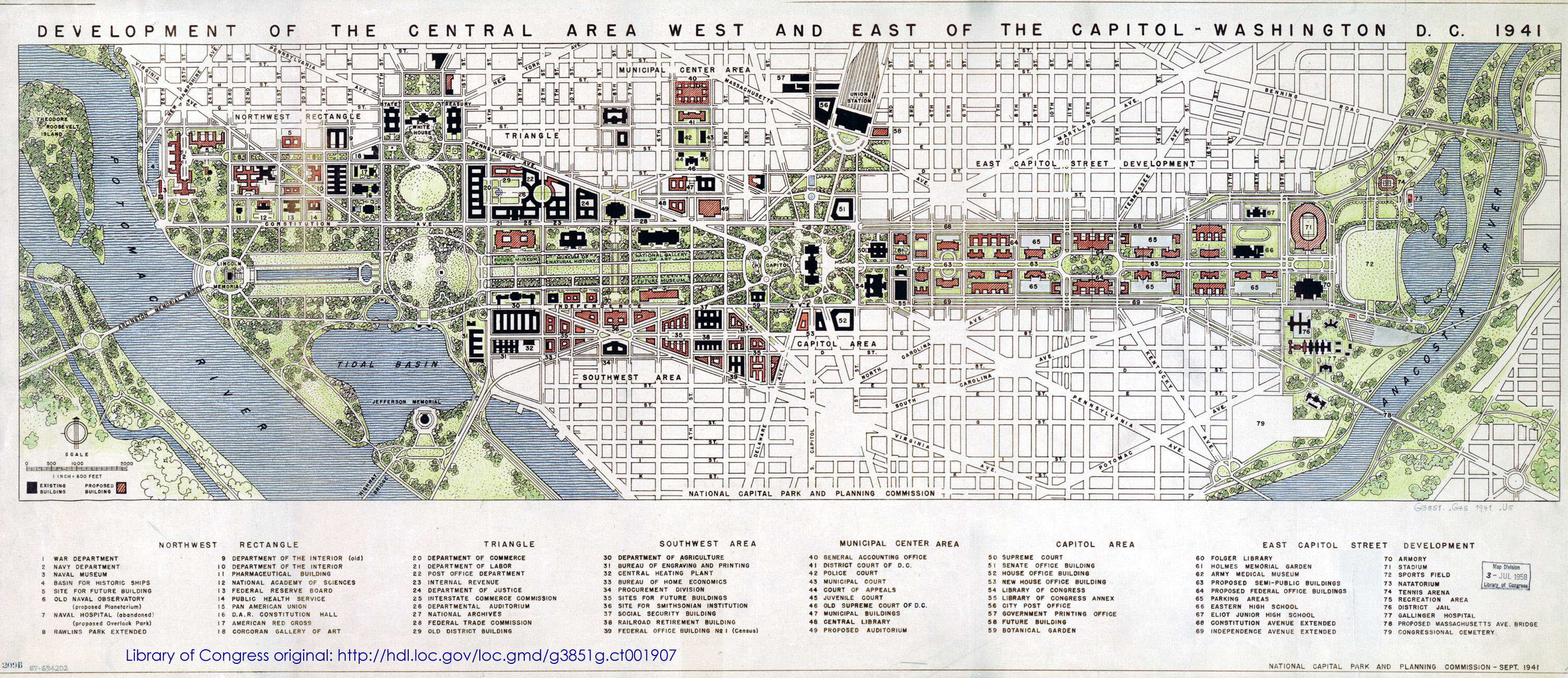
DC’s 1941 master plan is available through the Library of Congress. Published just months before Pearl Harbor, the plan is a fascinating look at the future pre-war planners envisioned.
The National Mall extends eastward to the bank of the Anacostia and dominates the plan. “Semi-public buildings, ” parking garages, and much more highway-like Constitution and Independence Avenues line the new Mall. On the other hand, Southwest retains its historic street grid, and isn’t cut off by I-395.
What else jumps out?
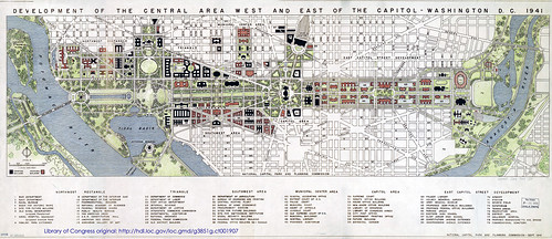
Image by National Capital Park and Planning Commission.
 Cross-posted at Greater Greater Washington. Cross-posted at Greater Greater Washington.
Average Rating: 4.5 out of 5 based on 220 user reviews.
May 9th, 2013 | Permalink
Tags: history, master planning, parks, roads/cars, transportation

This map, produced by the Transportation Planning Board, shows “managed highway lanes” in the DC area. That’s planner jargon for HOV and tolls.
It’s only highways. It doesn’t show non-highway HOV, like along Route 1 in Alexandria. The map also appears to show I-495 incorrectly, since the Beltway HOT lanes are free for HOV-3.
But it’s still interesting to see which highways have special characteristics. One thing that pops out is how Virginia has a fairly comprehensive and interconnected network, while Maryland is more hit-or-miss.
Managed lanes in the DC region, by TPB.
Average Rating: 4.9 out of 5 based on 202 user reviews.
May 2nd, 2013 | Permalink
Tags: maps, roads/cars, transportation
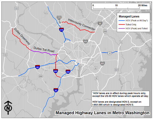
The DC Taxicab Commission today officially released their latest proposal for a uniform citywide taxi paint scheme. What do you think?

Image by DC Taxicab Commission.
This new design follows 4 previous options that had been proposed in December, and were widely criticized.
Here’s another view:
Image by DC Taxicab Commission.
Cross-posted at Greater Greater Washington.
Average Rating: 4.9 out of 5 based on 280 user reviews.
May 1st, 2013 | Permalink
Tags: roads/cars, transportation
|
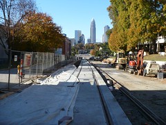
Charlotte streetcar construction. Photo by Reconnecting America on flickr. |
President Obama yesterday nominated Charlotte Mayor Anthony Foxx as the next Secretary of Transportation. If Foxx’s experience in Charlotte is any indication, he’ll make a strong choice.
During his nomination press conference, Foxx said “cities have had no better friend” than the US Department of Transportation under outgoing Secretary Ray LaHood, and that if confirmed he would hope to “uphold the standards” LaHood set. That’s great news.
The fact that Foxx comes from a major central city is also a huge benefit. It means he understands urban needs, which aren’t just highways.
Charlotte may not be New York, but it’s made great strides in the right direction. The city’s first rail line opened a few years ago, and a streetcar line is under construction now. Charlotte also gained bronze-level status as a bike friendly community in 2008, and launched bikesharing in 2012.
Foxx has been a strong advocate for urban rail, especially streetcars. He knows transportation and land use are tied at the hip, and has fought repeated attacks on Charlotte’s streetcar by former Mayor and current North Carolina Governor Pat McCrory.
He’s also worked as an attorney for bus manufacturer DesignLine.
Foxx also knows that state Departments of Transportation can sometimes be part of the problem. At the federal level, it’s common for USDOT to delegate responsibilities and funding to state DOTs, under the assumption the states have a better understanding of local needs. But state DOTs aren’t any more local than any huge centralized government. And since they usually focus on highways, the result is that federal dollars mostly go to highways as well.
Since Foxx fought with the state over Charlotte’s streetcar, he knows that funneling everything through state DOTs means states hold the cards. He knows that can hurt cities.
Finally, Foxx hired Arlington, VA’s former county manager, Ron Carlee, to run Charlotte’s city government. Foxx would have heard about Arlington’s reputation for progressive transportation planning during the hiring process, and presumably counted it in Carlee’s favor.
Of course, no one can really predict what kind of Secretary Foxx will be. When progressive champion Ray LaHood was first tapped for the job, the blogosphere worried his history as a Republican from rural Illinois meant he’d be a status quo highway builder.
But we do know that Foxx has made a priority of building transit in his home city, and has had to fight to make it happen.
Cross-posted at Greater Greater Washington.
Average Rating: 4.4 out of 5 based on 208 user reviews.
April 30th, 2013 | Permalink
Tags: bus, government, lightrail, people, roads/cars, streetcar, transportation
|
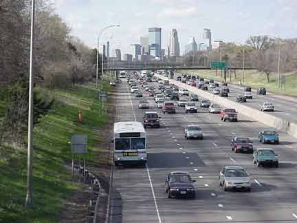
Photo from Minnesota DOT. |
Why not let buses drive on highway shoulders to get around congestion? According to a regional task force, that can be done, and it does often work, but it’s not quite as simple as putting a sign up and saying “let’s do it”.
With pressure mounting to stretch dollars and improve mobility, creative ideas like putting buses on shoulders are getting more attention. Maryland is considering the concept on I-270 and MD-5, and Virginia hopes to have a pilot project on I-66 operating in Arlington by 2014.
These would add to the handful of locations around the DC region where buses are already allowed to use the shoulder. The most notable example is the Dulles Access Highway inside the Beltway.
The main complicating issue is that highway shoulders are usually too narrow and not free enough from obstructions to immediately open them up to buses. Interstate highway standards call for 9 foot shoulders, but you need at least 10 feet for a bus, and really 11 feet is preferable. So a typical highway shoulder will have to be beefed up in order to be used as a bus lane.
That’s a lot easier, and cheaper, than just about anything else you could do. But it’s still a construction project that has to be planned and funded.
Minneapolis has an extensive network of over 300 miles of shoulder bus lanes on highways. But it’s taken them over 20 years to get there. They have a continuous program that adds a few miles each year. They started with the low-hanging fruit, and have worked up to more complicated stretches.
That’s the idea behind Virginia’s pilot project on I-66. At first, the section where buses will be allowed will be short. It won’t be a busway so much as a spot where buses can jump ahead of a queue of cars. But over time VDOT could lengthen the segment and provide a larger benefit.
For safety reasons, buses are usually only permitted to go 35 miles per hour when using shoulders. But that’s enough to get by the worst congestion. If traffic is moving faster than that, buses just stay in the regular lanes.
Cross-posted at Greater Greater Washington.
Average Rating: 4.7 out of 5 based on 152 user reviews.
April 19th, 2013 | Permalink
Tags: roads/cars, transportation
AAA’s official company spokesman John Townsend says GGW’s David Alpert is a “nerd, ” a “ninny, ” is “developmentally retarded, ” and is “like the Klan.”
If AAA thinks it’s good business practice for its spokespeople to make offensive personal attacks, then AAA isn’t a company I will ever have anything to do with. I don’t currently own a car, but someday I probably will. AAA won’t be my insurance partner when that day comes.
And in the mean time, if this is how AAA thinks and represents itself, guess how seriously I take their positions on transportation issues.
Average Rating: 4.4 out of 5 based on 237 user reviews.
April 18th, 2013 | Permalink
Tags: people, roads/cars, transportation
|
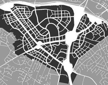
Tysons grid of streets, no. 2. |
Maryland and Virginia will both enact major new transportation funding bills this year. Neither bill says exactly which projects will be funded, but here are the top 10 projects in Maryland and Virginia that most deserve to get some of the funds.
Number 1: 8-car Metro trains. Metrorail is near capacity, especially in Virginia. More Metro railcars would mean more 8-car trains on the Orange, Blue, and Silver Lines.
Number 2: Tysons grid of streets. Tysons Corner has more office space than downtown Baltimore and Richmond put together. Converting it to a functional urban place is a huge priority.
Number 3: Purple Line. Bethesda, Silver Spring, Langley Park, College Park, New Carrollton. That’s a serious string of transit-friendly pearls. The Purple Line will be one of America’s best light rail lines on the day it opens.
Number 4: Baltimore Red Line. Baltimore has a subway line and a light rail line, but they don’t work together very well as a system. The Red Line will greatly improve the reach of Baltimore’s rail system.
Number 5: Silver Line Phase 2. The Silver Line extension from Reston to Dulles Airport and Loudoun County is one of the few projects that was earmarked in Virginia’s bill, to the tune of $300 million.
Number 6: Arlington streetcars. The Columbia Pike and Crystal City streetcars both have funding plans already, but could potentially be accelerated.
Number 7: Route 7 transit. Leesburg Pike is the next Rosslyn-Ballston corridor waiting to happen. Virginia is just beginning to study either a light rail or BRT line along it.
|

Corridor Cities Transitway, no. 8. |
Number 6: Corridor Cities Transitway. Gaithersburg has been waiting decades for a quality transit line to build around. BRT will finally connect the many new urbanist communities there, which are internally walkable but rely on cars for long-range connections.
Number 9: MARC enhancements. MARC is a decent commuter rail, but it could be so much more. Some day it could be more like New York’s Metro North or Philadelphia’s SEPTA regional rail, with hourly trains all day long, even on weekends.
Number 10: Alexandria BRT network. This will make nearly all of Alexandria accessible via high quality transit.
Honorable Mentions: Montgomery BRT network, Potomac Yard Metro station, Virginia Beach light rail, Southern Maryland light rail, VRE platform extensions.
Cross-posted at Greater Greater Washington.
Average Rating: 4.6 out of 5 based on 248 user reviews.
April 3rd, 2013 | Permalink
Tags: BRT, commuterrail, funding, government, lightrail, metrorail, roads/cars, streetcar, top10, transportation
|
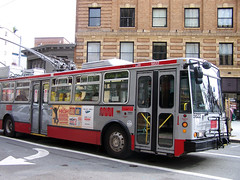
SF Muni bus. |
How do you stop car drivers from blocking bus lanes? Put cameras on buses, of course.
Unfortunately, transit lanes are often clogged by car drivers who either don’t know or don’t care that cars are not allowed in them. Enforcement is difficult, because violation is often so rampant that it’s not practical for the police to pull over every violating car.
DC’s 7th Street bus lane through Chinatown is a prime example.
But there is a solution. San Francisco is installing cameras on all its city buses, specifically to enforce the prohibition on cars in transit lanes. Human officers will review footage from the cameras and mail tickets to the owners of any cars illegally blocking the lane.
Bus cameras in San Francisco will not be used to ticket other types of moving violations such as speeding or running red lights. For now they won’t even be used to ticket car drivers that block bus stops. Current law prohibits any use other than ticketing transit lane violations.
Even that limited application will make a big difference, though. San Francisco has 17 miles of transit lanes, but without enforcement they’re no better at actually moving buses through traffic than 7th Street in DC.
If this idea works it could have a huge effect on bus planning nationwide. Bus lanes could become much more effective, and therefore likely to become more widespread.
Cross-posted at Greater Greater Washington.
Average Rating: 4.4 out of 5 based on 166 user reviews.
February 15th, 2013 | Permalink
Tags: bus, roads/cars, transportation
|
Development like this is impossible with parking minimums. |
Parking minimums don’t just affect parking. They have a huge impact on the overall scale of buildings. Developers that have to include off-street parking have to build bigger and bulkier buildings in order to make their projects work.
It’s true that parking minimums encourage more driving, but the impacts on urban design and architecture may be even more important. The problem is that parking lots take up a lot of space, which makes development of small properties harder.
As a result, developers faced with parking minimums always try to build on the largest piece of land possible.
So if you like old style main streets, parking minimums are the enemy.
In places without parking minimums it’s more practical to build charming narrow buildings, like those that populate historic main streets all over the country. But where parking minimums exist, developers need larger properties big enough to fit parking lots.
Take a look at the buildings in these two pictures. They’re ostensibly similar. Both are 3 stories with a 4th floor attic. Both are primarily brick. Both have shops on the ground level, with other uses above. The key difference is that the left picture is a single building built by a single developer, while the right picture shows a block of narrow buildings on individual properties.
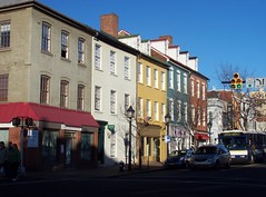
University Drive, Fairfax.
Image from Google. |
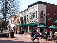
King Street, Alexandria.
Image from BeyondDC. |
Which one do you like better? Most people prefer the buildings in the right picture, because they’re built at a more human scale. Even though the building on the left is about the same height, it seems like a hulking monster because it’s so long.
One of the big reasons it’s so long: Parking.
Parking lots take up so much space and push developers towards larger buildings because parking lots aren’t just parking spaces. They’re really entire streets. Since you can’t get to a parking space unless it’s got a driving lane next to it, every row of parking spaces has to have an entire street built in front of it.
Unfortunately, it’s geometrically impossible to fit a two-way driving lane and a bunch of parking spaces behind a main street style 25-foot-wide building. Thus, developers need bigger properties, and old style main streets are essentially illegal to build.
Parking garages and underground parking are even worse. They don’t just need driving lanes, they need ramps too, not to mention elevators, stairs, and air ducts. So anyone who wants to build something that requires structured parking needs even more land.
This is one of the biggest reasons why contemporary development happens at the scale that it does. There are other reasons too, but this is a key one. In order to meet parking requirements imposed by city governments, developers have to scale-up their buildings to fit parking lots. In turn, those 19th Century main streets that everyone loves so much are effectively impractical and illegal to build.
Average Rating: 4.4 out of 5 based on 264 user reviews.
January 11th, 2013 | Permalink
Tags: architecture, roads/cars, transportation, urbandesign
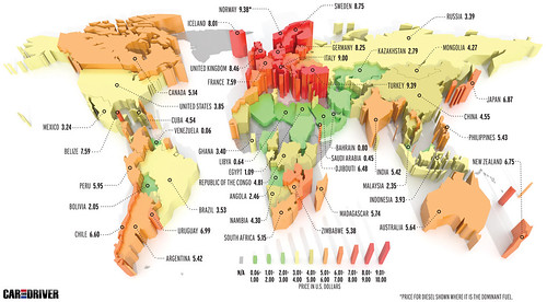
According to an international survey, the price of gasoline in the United States is still lower than in most of the rest of the world’s developed countries. The survey, by Car and Driver magazine, included this handy map showing the average price of 1 gallon of gas in US dollars for most of the world:
Average Rating: 4.6 out of 5 based on 189 user reviews.
January 7th, 2013 | Permalink
Tags: economy, energy, roads/cars, transportation
|
Media


Site
About BeyondDC
Archive 2003-06
Contact
Category Tags:
Partners
|