|
Special Features


Image Libraries


|
|
Blog
The Walter Reed campus is one of the largest redevelopment sites in the District. It may one day become the biggest node of activity between Columbia Heights and Silver Spring. Three teams are competing for development rights, and it’s now up to DC to select which team will get the opportunity to build.
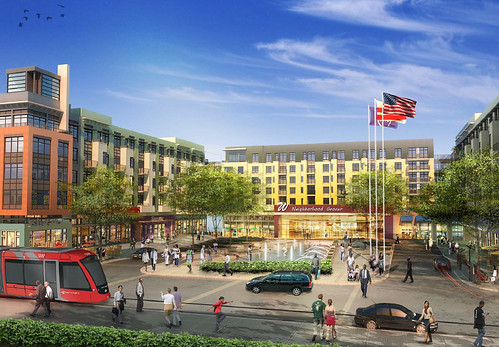
Hines’ proposal. All images from the Walter Reed Local Development Authority.
Much of the media coverage of the 3 options has so far focused on which of them might accommodate a Wegmans grocery store. But the physical form matters more than the individual tenants. To function as a neighborhood downtown, Walter Reed must be walkable, as transit-oriented as possible, and fully integrated with the surrounding neighborhood.
Specifically, Georgia Avenue must be the main street. Developers of large properties often try to mimic shopping malls and pull the center of activity inwards, towards the center of their own site, and away from the edges. That’s why Ellsworth Drive became the center of Silver Spring, and why CityCenterDC’s central plaza won’t face a public street.
But that arrangement makes a place feel artificial, and limits the spillover economic benefits to surrounding parcels. It also pushes more people to drive, when the main transit spine isn’t front and center to the densest cluster of development.
With no Metro station at Walter Reed, and Takoma station a long walk to the east, the major transit access will be from Georgia Avenue. First the 70-series bus line, and eventually streetcar. Since Georgia Avenue is both the transit spine and the community’s existing main street, it should be the heart of activity for Walter Reed.
Hines and Roadside proposals
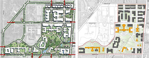
Hines (left), Roadside (right).
The Hines and Roadside concepts are similar. Both propose the southern half of the property be suburban in character, with a town center clustered in the northern half.
Hines shows a public park fronting on Georgia Avenue, which would be a nice amenity. But that park has the unfortunate effect of pushing the hub of its town center back nearly 2 blocks away. One rendering even shows the streetcar pulled off Georgia Avenue, rerouted to better serve Walter Reed and more poorly serve everywhere else.
It’s harder to tell from the plans whether the Roadside proposal treats Georgia Avenue, Dahlia Street, 12th Street, or 13th Street as the main street. It appears to be about the same density as Hines, but without the town center park.
Forest City proposal
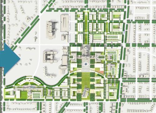
Forest City.
Seemingly the densest of the 3 proposals, Forest City is the only finalist team that attempts to urbanize the southern half of the property. It also maximizes building frontage along Georgia Avenue, while providing ample parks along 13th Street.
Forest City does propose to make Dahlia Street a retail spine, while they do not say what sort of land uses would front on Georgia Avenue. There may be enough added density in their proposal to support both Dahlia and Georgia as retail spines, or maybe they’d make Georgia all residential. The former would be fine, the latter wouldn’t.
At first glance, Forest City’s proposal appears to be the best of the 3, but all the development teams must release more details, especially their proposed ground-floor land uses for every street.
No matter which team is ultimately picked, a town center near Georgia and Dahlia is better for DC than what’s there today.
 Cross-posted at Greater Greater Washington. Cross-posted at Greater Greater Washington.
Average Rating: 4.8 out of 5 based on 272 user reviews.
July 31st, 2013 | Permalink
Tags: development, streetcar, transportation

Here are two pictures of the same block of H Street, taken 10 years apart.
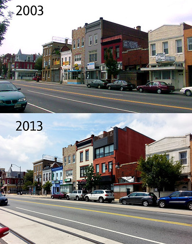
H Street NE between 5th and 6th streets.
Average Rating: 4.4 out of 5 based on 245 user reviews.
July 29th, 2013 | Permalink
Tags: galleries, The New America
|
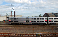
Almost $20 million will go to new VRE railcars. |
For years, leaders in Northern Virginia have been asking Richmond to let Northern Virginia raise its own money to spend on its own transportation priorities. They are finally getting the chance.
When the Virginia General Assembly passed a broad new transportation funding bill earlier this year, it included a section for Northern Virginia to raise and allocate hundreds of millions of dollars per year. Those new taxes began rolling in on July 1, with the beginning of Virginia fiscal year 2014.
On Wednesday night, the Northern Virginia Transportation Authority (NVTA) officially approved its first set of projects. The authority allocated about $210 million, split roughly evenly between transit and roads.
The largest projects include the Silver Line’s Innovation Center Metro station, new VRE railcars, and widenings along Route 28.
NVTA also approved a bond validation lawsuit that will preemptively ask Virginia courts to rule on NVTA’s legality. That process should take 6-9 months, and NVTA will have to wait until it’s over to actually start spending money. Taking the suit to court now means NVTA won’t have to spend years fending off other legal challenges.
The project list is shown below. For more details, see the project description sheets on NVTA’s website.
| Project |
Funding
in millions |
Location |
| Transit and multimodal projects |
| Innovation Center Metro station |
$41 |
Fairfax Co. |
| VRE railcars |
$19.8 |
Regional |
| VRE Lorton station 2nd platform |
$7.9 |
Fairfax Co. |
| WMATA buses |
$7 |
Regional |
| WMATA Orange Line traction power upgrades for 8-car trains |
$5 |
Regional |
| DASH buses |
$3.3 |
Alexandria |
| Potomac Yard Metro station environmental study |
$2 |
Alexandria |
| Crystal City multimodal center bus bays |
$1.5 |
Arlington |
| VRE Gainesville extension planning |
$1.5 |
Regional |
| VRE Alexandria station pedestrian tunnel & platform improvements |
$1.3 |
Alexandria |
| Herndon Metro station access improvements (road, bus, bike/ped) |
$1.1 |
Fairfax Co. |
| ART buses |
$1 |
Arlington |
| Leesburg park and ride |
$1 |
Loudoun |
| Loudoun County Transit buses |
$0.9 |
Loudoun |
| Route 7 Tysons-to-Alexandria transit alternatives analysis (phase 2) |
$0.8 |
Regional |
| Falls Church pedestrian access to transit |
$0.7 |
Falls Church |
| Duke Street transit signal priority |
$0.7 |
Alexandria |
| PRTC bus |
$0.6 |
Prince William |
| Alexandria bus shelters & real-time information |
$0.5 |
Alexandria |
| Van Buren pedestrian bridge |
$0.3 |
Falls Church |
| Falls Church bus shelters |
$0.2 |
Falls Church |
| Road projects |
| Rt 28 – Linton Hall to Fitzwater Dr |
$28 |
Prince William |
| Rt 28 – Dulles to Rt 50 |
$20 |
Fairfax Co. |
| Belmont Ridge Road north of Dulles Greenway |
$20 |
Loudoun |
| Columbia Pike multimodal improvements (roadway, sidewalk, utilities) |
$12 |
Arlington |
| Rt 28 – McLearen to Dulles |
$11.1 |
Fairfax Co. |
| Rt 28 – Loudoun “hot spots” |
$6.4 |
Loudoun |
| Chain Bridge Road widening |
$5 |
Fairfax City |
| Boundary Channel Dr interchange |
$4.3 |
Arlington |
| Rt 1 – Featherstone Rd to Mary’s Way |
$3 |
Prince William |
| Edwards Ferry Rd interchange |
$1 |
Loudoun |
| Herndon Parkway intersection with Van Buren St |
$0.5 |
Fairfax Co. |
| Herndon Parkway intersection with Sterling Rd |
$0.5 |
Fairfax Co. |
Cross-posted at Greater Greater Washington.
Average Rating: 4.7 out of 5 based on 186 user reviews.
July 26th, 2013 | Permalink
Tags: BRT, bus, commuterrail, funding, government, lightrail, metrorail, roads/cars, transportation
DC has agreed to a preliminary deal to build a dedicated soccer stadium at Buzzard Point, and to redevelop the Reeves Center at 14th and U streets NW with a new mixed-use building.
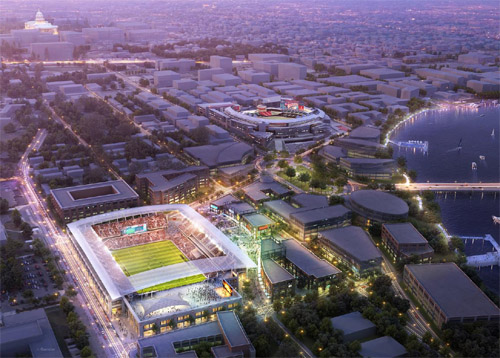
Rendering of a Buzzard Point soccer stadium. Image from DC United.
Under the deal, the stadium would be located at the southern base of Potomac Avenue SW, just 4 blocks from Nationals Park. It would seat 20, 000-25, 000 people, and cost around $150 million to build. DC United would pay for construction, but the District would donate the land.
Development firm Akridge currently owns the land for the stadium. Instead of buying the land outright, DC would swap it for the Reeves Center. Akridge would then tear down and redevelop the Reeves Center, while United would build a stadium at Buzzard Point.
The deal must still be approved by the DC Council.
Is this a good idea?
Is Buzzard Point the right place for a stadium? Usually it’s not a great idea to put two large stadiums so close to each other, because when so much land is given over to sports, there’s not enough left over to build a functioning mixed-use neighborhood. That’s a major problem with Baltimore’s Camden Yards area, with the South Philadelphia Sports Complex, and with most multiple-stadium complexes.
But Buzzard Point may be different. Nationals Park has helped induce strong redevelopment east of South Capitol Street, and along M Street SE/SW, but the west side of South Capitol Street has lagged behind. The west side clearly functions as a different place, and a stadium there could help.
On the other hand, maybe the west side of South Capitol Street hasn’t redeveloped as much precisely because Nationals Park superblock is a barrier.
From a transportation perspective, Buzzard Point makes sense. Although it’s further from a Metro station than Nationals Park or RFK, it’s still within walking distance. And actually, a little bit of distance is a good thing, since it means soccer fans will pass by retail areas between the stadium and Metro, and that the most valuable land nearest the station can still be used for mixed-use development.
On top of the Metro connection, DC is planning for both the Georgia Avenue and Anacostia streetcar lines to terminate at Buzzard Point, directly adjacent to the proposed stadium site.
As for the Reeves Center, it cannot be redeveloped soon enough. A large city office building was a useful and necessary investment along U Street in the 1980s, when central DC was declining. But now the neighborhood is booming, the land is in high demand, and the Reeves Center is obsolete.
In a perfect world, I still think Poplar Point would have been a better location for a soccer stadium. But in the real world, Buzzard Point works. Since DC taxpayers won’t be on the hook to pay for construction, let’s do it.
Cross-posted at Greater Greater Washington.
Average Rating: 4.8 out of 5 based on 265 user reviews.
July 25th, 2013 | Permalink
Tags: development
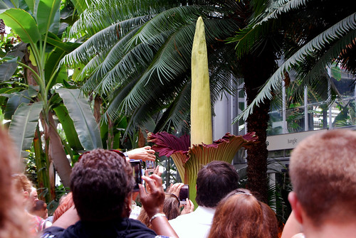
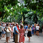
One of the world’s rarest and stinkiest giant flowers is blooming now at the US Botanical Gardens. But if you want to to see it, you have to act fast. It will likely wilt in just a few days.
The titan arum can reach 10 feet in height, smells like rotting dead flesh, and can go decades between blooms. When a bloom does happen, it’s a big draw at the usually-quiet botanical garden.
I went yesterday and took a few pictures. I barely noticed the smell.
Average Rating: 4.9 out of 5 based on 173 user reviews.
July 23rd, 2013 | Permalink
Tags: environment, galleries, parks
Sunday’s Washington Post featured a big story about gentrification on 14th Street, including the claim that it “recently surpassed Columbia Heights as the densest area in the city.” Is that true? The US Census can tell us.
Using American FactFinder, I created this map illustrating the population density of DC’s central neighborhoods.

5 of DC’s 6 overall densest census tracts border on 14th Street, between downtown and the northern end of Columbia Heights. It’s definitely the city’s densest string of neighborhoods.
But is it denser north or south of Florida Avenue? That depends how you count. While the stretch of 14th Street between Florida Avenue and P Street remains a little sparser than in Columbia Heights, the stretch from P Street south to Thomas Circle is the densest single tract in DC.
Cross-posted at Greater Greater Washington.
Average Rating: 4.7 out of 5 based on 180 user reviews.
July 22nd, 2013 | Permalink
Tags: demographics, maps
I absolutely love exploring the world with Google Street View. Oh sure, real life is infinitely better, but I can’t afford plane tickets to all the places I can get lost in with Street View.
Yesterday I discovered Street View covers Midway Atoll, of Battle of Midway fame. The island was used for decades by the US military but is now depopulated except for a few visits per year by researchers. But all the buildings are still there, not to mention about 440, 000 albatross birds.
It’s fascinating, and a little creepy. Take a look.
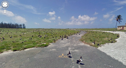
Every black smudge you see in this picture is a 3-foot bird. And yes, that’s a bike path.
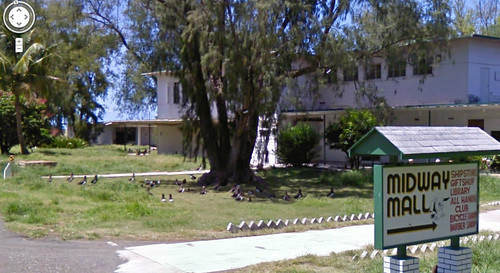
Downtown Midway, abandoned.
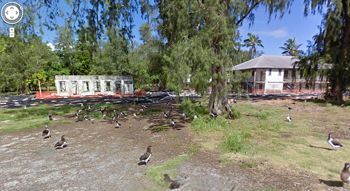
Ruins are everywhere, but the birds don’t mind.
Average Rating: 4.6 out of 5 based on 272 user reviews.
July 19th, 2013 | Permalink
Tags: bike, fun, history, preservation, transportation
Gaithersburg is interested in starting its own local bus network, and will soon begin a feasibility study to consider whether that makes sense.
Gaithersburg has a number of walkable areas, but they’re poorly connected by transit. Most of the bus lines are designed to get riders to Shady Grove Metro station, and they don’t come very often. A new system would be more oriented towards circulation between Gaithersburg’s own nodes.
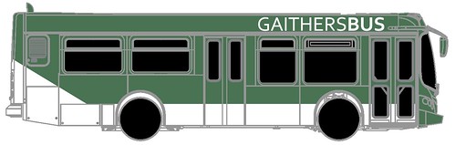
Unofficial concept of what a Gaithersburg bus might look like. Image and cheesy name by BeyondDC.
The State of Maryland is already planning to build the Corridor Cities Transitway BRT line through Gaithersburg, and Montgomery County is considering a line on Frederick Avenue as part of its BRT network planning, but those projects are still years away from completion. Even when they’re done, Gaithersburg will still need better bus service on other corridors.
One particularly important destination might be Gaithersburg’s historic downtown, which has a MARC station but won’t have stations on either BRT line.
Gaithersburg’s local system could be operated by WMATA as part of Metrobus, or by Montgomery County as part of Ride-On, or it could be something else, like the Bethesda Circulator. The study will presumably look into what would work best.
With its own system, Gaithersburg would have more control over routes and schedules as compared to WMATA or Ride-On. Its own system would also be more recognizable, and could potentially be cheaper to operate. On the other hand, it would be more difficult to set up.
The Metropolitan Washington Transportation Planning Board approved the study at its meeting yesterday, as part of its Transportation / Land Use Connections planning assistance program.
Cross-posted at Greater Greater Washington.
Average Rating: 4.6 out of 5 based on 248 user reviews.
July 18th, 2013 | Permalink
Tags: BRT, bus, transportation
In 2012 news circulated that a Czech company wanted to build a flying bicycle. I said it was a terrible idea. Now, someone has actually done it. Watch:
Atlas Human-Powered Helicopter. Not exactly practical for commuting.
Average Rating: 4.8 out of 5 based on 250 user reviews.
July 16th, 2013 | Permalink
Tags: bike, fun, transportation
|
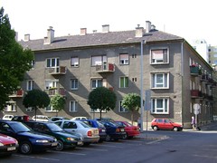
Photo by photobeppus on flickr. |
DC planning director Harriet Tregoning announced today that minimum parking requirements in transit-oriented neighborhoods will remain in the new zoning code.
As part of its rewrite of the zoning code, DC’s Office of Planning (DCOP) had proposed eliminating mandatory parking requirements in the densest, most transit-friendly parts of the city. Anyone who wanted to build parking would still be allowed to do so, but it wouldn’t be mandatory. The new zoning code will lower requirements for parking, but won’t eliminate them completely.
The new proposal will keep parking requirements for institutional and industrial land uses similar to what they are now. The requirement will drop by about half for residential and office buildings.
Under existing zoning, any new residential units are required to build parking spaces, whether the owner wants them or not. The requirement is a huge subsidy for drivers, and a major burden on car-free households. It also adds tremendously to the cost of new housing.
There is a silver lining: DCOP is still planning to eliminate parking requirements in downtown DC.
Cross-posted at Greater Greater Washington.
Average Rating: 5 out of 5 based on 227 user reviews.
July 12th, 2013 | Permalink
Tags: government, roads/cars, transportation
|
Media


Site
About BeyondDC
Archive 2003-06
Contact
Category Tags:
Partners
|


